Horncliffe Circle, Hawskworth Moor, West Yorkshire

Stone Circle:  OS Grid Reference – SE 13335 43532

Getting Here

Get to the famous Dick Hudson’s pub on the south-side of Ilkley Moor and go east for about 700 yards till you get to Weecher reservoir (posh doods go yachting there).  From here cross the road and walk on for 150 yards till you reach the stile which takes you onto the moors. Walk!  Follow the footpath and you’ll go over another wall before eventually hitting the beautiful fresh waters of Horncliffe Well (this has never dried up – even in the summers of ’76 and ’95).  Sit here for a while before heading for the circle which is on the east-side of the moorland fence just a coupla hundred yards up onto the moor (you’ll cross a coupla streams before reaching the site).  You’ll know you’re close when, to your left by the fence, you’ll see a boundary stone with the name ‘Thos. Pulleyn’ engraved on it.

Archaeology & History
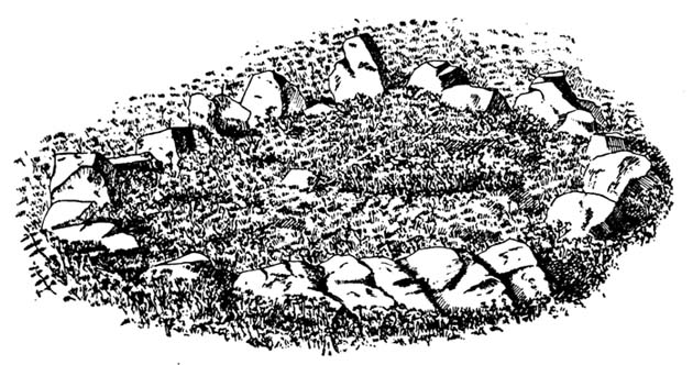
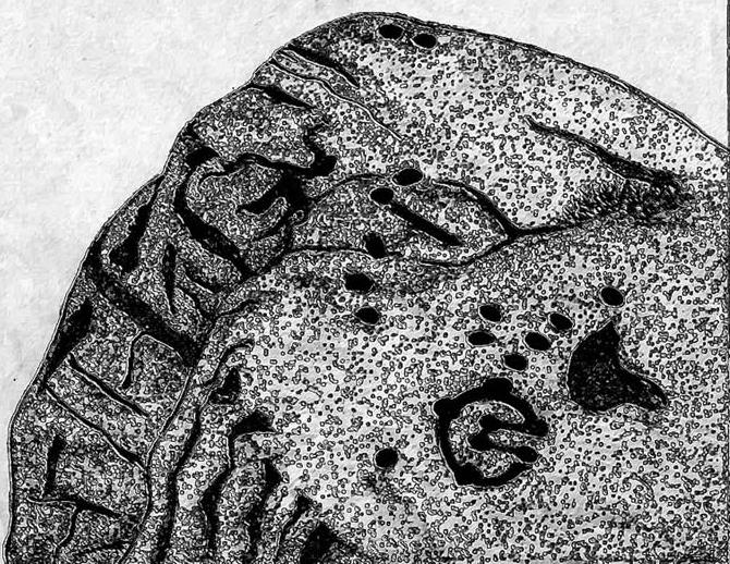
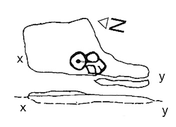
Early drawing of Horncliffe Circle (Speight 1898)

Horncliffe is a bittova strange site, inasmuch as we don’t honestly know precisely what it is, nor its age.  It used to be categorized as a ‘stone circle’, but this was abandoned many moons ago.  The inner circle of this ellipse-shaped monument was thought to have perhaps contained a burial, but Victorian excavations here found no such evidence; no burials have ever been found, though fires were evidently burned in the small central ring.

Nowadays I’m of the opinion that this was more for living-in, than any ritual site.  It ‘smells’ like that anyway (modern OS-maps now term it as an ‘enclosure’); and this may be borne out by the ancient name of the trackway travelling north from here called ‘Castle Gate’, meaning ‘entrance or path by the fortification.’  Faint ‘cup-markings’ reported by Harry Speight (1898) on the outer edge of the ring are very likely Nature’s handiwork.

Horncliffe is a double-ringed ellipse structure, surrounded on its northern side by a natural embankment of earth.  It was first mentioned in J.N.M. Colls’ (1846) survey, but more was said of it by James Wardell in 1869, who told that,

“there is a circle of stones of various sizes, from three-feet to five-feet in height; they are chiefly set upon their edges and are of sandstone grit.  This circle is forty-three feet in diameter and within it there is a smaller circle, composed of stones of the same composition…and set in the same manner.”

A few years later, the Yorkshire literary giant Harry Speight (1898) penned his first words about this curious circle, saying:

“The best example of a stone circle in the vicinity of Bingley lies on the moor close to the parish boundary, on land belonging to Mr Fawkes, of Farnley Hall.  It is a complete circle, consisting of about twenty stones, placed close together (a very unusual arrangement), from two to four feet high, the circumference being about 35 yards.  An excavation was made in the middle of it some years ago, when bits of flint were found, but no trace of burial.  It is built on a slight slope of the moor, facing the south, and is now much concealed by heather.  It is, doubtless, the oldest known evidence of man’s handiwork remaining in the neighbourhood of Bingley, and there is small doubt that it was originally intended to fence a burial, such “Druids’ Circles” being primarily meant to enclose places of sepulchre in the same way that walled enclosures came to be adopted round our churchyards.  A large flat stone on the top side, about three yards distant, is marked with cups and channels, and probably was in the centre of the circle originally.”

When Arthur Raistrick (1929) visited the circle, his measurements differed somewhat from those of Mr Wardell, telling the site to have diameters of 25 feet (east-west) and 32 feet (north-south), with 46 stones in the outer ring and 17 in the inner circle.

This is one of many sites on these moors that I slept at over the years when I was a kid.  It used to be a really peaceful spot that was rarely troubled by other visitors (not sure if it’s still the same though).

Folklore

Although we have nothing specific to the circle, around the nearby Horncliffe Well a coupla hundred yards away we had accounts told us by the old warden whose job it was to look after this moorland, that will-o-the-wisps had been seen here.  There is a seeming alignment to the equinoxes from here to Reva Hill – though this is more fortuitous than deliberate.  A dowsing survey found aquastats in and around the circle, but no plan of these were ever made.

References:

  1. Bennett, Paul, The Old Stones of Elmet, Capall Bann: Milverton 2001.
  2. Colls, J.N.M., ‘Letter upon some Early Remains Discovered in Yorkshire,’ in Archaeologia 31, 1846.
  3. Raistrick, Arthur, ‘The Bronze Age in West Yorkshire,’ in YAJ 1929.
  4. Speight, Harry, Chronicles and Stories of Old Bingley, Elliot Stock: London 1898.
  5. Wardell, James, Historical Notices on Ilkley, Rombald’s Moor, Baildon Common, etc., Leeds 1869.

© Paul Bennett, The Northern Antiquarian


Woman Stone, Askwith Moor, North Yorkshire

Cup-and-Ring Stone:  OS Grid Reference – SE 17103 50541

Also Known as:

  1. Carving no.520 (Boughey & Vickerman)

Getting Here

Takes a bit of finding this – but if you like your rock art, it’s worth the search!  You can follow directions for the getting to the Man Stone then, when you reach it, look to the near horizon to the east.  Get to the bottom of the sloping hillside where a large rounded boulder sits and walk up the slope about 10 yards.  Look around here cos you’re very close.

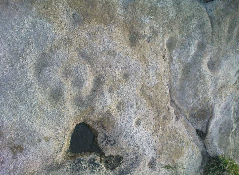
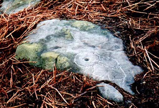
Woman Stone carving
Carving highlighted in chalk

Alternatively, from the Askwith Moor Road, follow the path to the triangulation pillar on Shooting House Hill.  Keep going for another 100 yards and check a small path to your left (south).  Follow this down until you get to the top of the slope.  Go to the bottom of the slope and look around!

This carving is best checked out in winter and early spring: if you go here in summer & autumn there’s bracken covering the entire site & you’ll never find it!

Archaeology & History

Drawing by Inmaculada Ibanez-Sanchez

This stone was first discovered by Graeme Chappell and I during one of our many ambling explorations here in the early 1990s and was first mentioned in my Old Stones of Elmet (pp.149-152).  Marija Gimbutas would have loved this seemingly matriarchal-looking cup-and-ring carving, suggestive of many Mother Goddess images she found across Europe – hence its title!

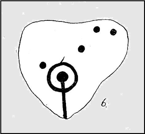
Woman Stone design (after Boughey & Vickerman)

I don’t think that the old-school archaeological types would lower themselves to say such a thing, but as I aint one of them I’m quite confident in saying that this carving does seem to be a pictorial representation of a female figure: one of the earliest of its kind in the British Isles? (check its nearby male compatriot, the Man Stone – a distinctly human figure and one of the earliest of its kind in the British Isles)  Very close by we are left with old place-name remnants pointing directly at the presence of pre-christian goddess remains in the mythic landscape – an issue I’ll expand on in the near future.

In the survey by more recent rock art students Boughey & Vickerman (2003), their illustration of the carving makes it look even more like an early female figure! (though I hear they don’t like people giving the carvings names – unless, of course, one of them lot names it…)

References:

  1. Bennett, Paul, The Old Stones of Elmet, Capall Bann: Milverton 2001.
  2. Boughey, Keith & Vickerman, E.A., Prehistoric Rock Art of the West Riding, WYAS: Wakefield 2003.
  3. Gimbutas, Marija, The Language of the Goddess, Harper-Collins: San Francisco 1989.
  4. Gimbutas, Marija, The Civilization of the Goddess: The World of Old Europe, Harper-Collins: San Franciscoo 1991.

© Paul Bennett, The Northern Antiquarian

Windy Hill Circle, Baildon Moor, West Yorkshire

Stone Circle (destroyed):  OS Grid Reference – SE 138 403

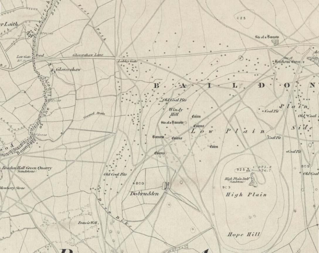
Windy Hill on 1852 map

Archaeology & History

The early northern antiquarian, J.N.M. Colls (1846), described visiting a ‘druidical circle’ of stones due east of the Dobrudden prehistoric graveyard, but it seems to have been completely destroyed soon after he wrote his essay, with the stones taken away for use in road-building.  He told that here was,

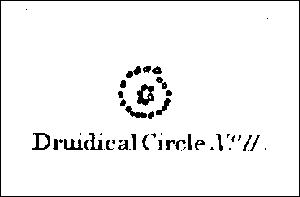
“a double circle of stones, the outer ring numbering eighteen, with six stones making up the inner circle.”

…and his illustration shows just that!  It’s possible that this inner ring may have covered a burial.  Harry Speight — aka, ‘Johnnie Gray’ (1891) — is the only other writer I’ve found that refers to the megalithic remains up here, although he gave no additional details.

Windy Hill Circle (after Colls, 1846)

The site was to be found across the High Plain and Windy Hill, on the western edge of Baildon Hill, where there was once a greater profusion of seemingly neolithic and Bronze Age remains.  Another possible early reference to the site is in Collyer & Turner’s Ilkley (1885), where they talk of a circle “on the highest part of the eastern moor,” fifty-six feet across with a similar appearance to the Pennythorn Hill circle, although they describe it as overlooking the hamlet of Sconce, which is hardly possible from the Windy Hill side of Baildon Moor.

The site looked across the horizon from south, through west to north and if used astronomically would have been used to observe sun and moonset times.  Although we find a number of cup-and-ring stones in the vicinity, it really does seem that this site has bit the dust!

References:

  1. Bennett, Paul, The Old Stones of Elmet, Capall Bann: Chieveley 2001.
  2. Colls, J.N.M., ‘Letter upon some Early Remains Discovered in Yorkshire,’ in Archaeologia 31, 1846.
  3. Collyer, Robert & Turner, J. Horsfall, Ilkley, Ancient and Modern, William Walker: Otley 1885.
  4. Gray, Johnnie, Through Airedale, from Goole to Malham, Elliot Stock: London 1891.

© Paul Bennett, The Northern Antiquarian

William Walker Stone, Keighley Moor, West Yorkshire

Cup-and-Ring Stone:  OS Grid Reference – SD 99904 40659 

Getting Here

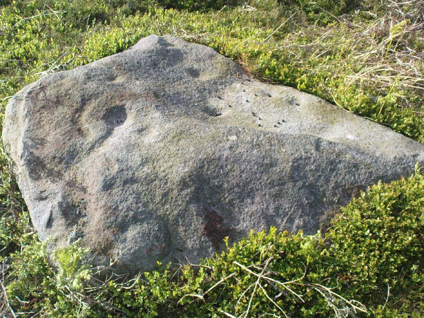
William Walker's Cup-and-Ring
William Walker’s Cup-and-Ring

You need to get to the eastern edge of Keighley Moor by taking the country road northwest out of Oakworth (one of two roads) and head to the end of Newsholme Dean Valley at Slippery Ford.  You can park up at Slippery Ford at Morkin Bridge, then walk up the road for 250 yards, turning sharp left up the dirt-track.  Walk along its wibbly route for another 250 yards and watch out for the large boulder in one of the fields on the left.  That’s it!

Archaeology & History

Sketching the design

I came across this previously unrecorded carving in August 2006 after returning from an amble over the moors in the pouring rain and was fortunate to be able to make out the faint design, for, as with most cup-and-ring carvings, depending on the daylight conditions determines whether the carving is visible or not.  Although some of the cup-marks on here are quite distinct, several are very faded and — as usual! — there are a number of dubious ones to work out!

Central design of cups & ring
Main design of cups & ring

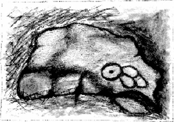
The carving gets its name due to the rock having a carved epitaph for an old local farmer — called William Walker — on its eastern face.  There are also the letters “I.W.” carved on its sloping upper face, which looks typical of boundary mark notation, though this stone aint been on any boundary for at least 160 years (I aint checked earlier records).  But much older on top of the rock we find perhaps as many as 20 cup-markings, which at first I first thought might be natural, but this was suddenly halted when I noticed in the bad light a large circle with several cups along it, inside of which were two other cups.  On the southern edge of the rock it seems there may be another 3 or 4 cup-marks, one with a line running down (possibly natural).  I took a couple of pictures when I first found it but they weren’t too well-defined.  The ones here are a little better.

Artist's impression - by Angela Hainsworth
Artist’s impression by Angela Hainsworth
Close-up of ring, cups & lines

The main feature here is obviously the curious ‘ring’ above a small eroded basin, consisting of several cups, with two in the centre.  On closer examination it appears that the ‘ring’ is in fact an unfinished circle with the two central cups having lines running from them to the incomplete ring, leaving a gap or opening at the bottom.  The lack of other cup-and-ring carvings in the vicinity (apart from the simple Cob Stone, 750 yards away below Grey Stones Hill) is an oddity.  A few more ventures onto the local hills are definitely required to see if anything else can be found!

Acknowledgements:  With thanks to Angela Hainsworth for her assistance and sketch of the design.

© Paul Bennett, The Northern Antiquarian

Werneth Low, Hyde, Lancashire

Settlement (destroyed):  OS Grid Reference – SJ 959 928

Archaeology & History

Known by this name – Werneth – since at least the 12th century, place-name masters Ekwall, Smith and others have tended to think the place derives from a hypothetical British word, *verno-, meaning alder trees – though I aint so sure misself.

It’s been difficult to ascertain the precise nature of this prehistoric arena. Many mesolithic flint finds and old stone axes have been found around the area, but it seems primarily to have developed into a neolithic and Bronze Age settlement and burial site. A number of cairns were once here, and both rounded and linear earthwork features occur in the area; but there’s been considerable disturbance in and around the site and without in-depth archaeo-surveillance, much remains hidden.

References:

  1. Abraham, John Harris, Hidden Prehistory around the North West, Kindle 2012.
  2. Ekwall, E., The Place-Names of Lancashire, Manchester University Press 1922.
  3. Marriott, W., The Antiquities of Lyme and its Vicinity, Stockport 1810.
  4. Nevell, Michael, Tameside before 1066, TMBC 1992.

© Paul Bennett, The Northern Antiquarian 


Stoodley Pike Circle, Mankinholes, West Yorkshire

Ring Cairn (destroyed):  OS Grid Reference – SD 9730 2418

Getting Here

Stoodley Pike is unmissable! Get to either Hebden Bridge or Todmorden – ask someone – then get to it! Nice climb – nice view – excellent moors all round!

Archaeology & History

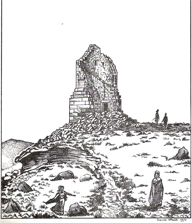
Artist’s impression of Stoodley Pike Circle (bottom left of ruin)

All traces of this site have gone, but local gossip still tells there was once something here. When building work commenced on the huge folly in 1814, in clearing the ground “an accumulation of stones (and)…a quantity of bones” were unearthed. After the huge folly had been built, a curious ritual was made by local Freemasons, from here to the nearby Slake Well. The circle was only a small one, but ideal for the spirit of the ancestor to both look-out from, and fly across the landscape.  In another description of the place from 1832 — wrote E.M. Savage (1974) — local writer and poet, William Law, told how “a rude heap of stones had stood on the site from time immemorial.”

Folklore

Suggested by earlier writers to have been an old beacon site, though evidence for this is uncertain.  The site was said to be a meeting place of the “gude grannies,” who met here and told old stories.  E.M. Savage (1974) told us:

“Another story was that the cairn marked the grave of an old chietain and that the bones of a human skeleton had been found… A contemporary of (William) Law, called Holt…stated that this was so.  Another story was that someone had been murdered and buried there.  Many years later, Law quizzed the workmen.  Bones had been found but no one knew whose bones, or their age, so the mystery remained.

“Yet another story had it that the occupant, presumably owner, of Stoodley, had to keep the original Pike, the cairn, in neat and good order.  If a single stone was out of place, no one could sleep.  The banging of doors and other noises started up, to remind the owner to tidy up the stones.  Elusive flames were to be seen playing round the stones. Sor the stories went.”

As can be seen in the artist’s drawing above, done more than a century after the cairn had been destroyed, a ring of stones is shown just below the remains of the earlier of the Peace Monuments, which today carries the old name of Stoodley Pike.

References:

  1. Booth, Thomas, Ancient Grave Mounds on the Slopes of the Pennine Range, R. Chambers: Todmorden 1899.
  2. Savage, E.M., Stoodley Pike, Todmorden Antiquarian Society 1974.

© Paul Bennett, The Northern Antiquarian

Torr Mor, Applecross, Ross & Cromarty

Settlement: OS Grid Reference – NG 709 431

Getting Here

Pretty easy to get to.  Go south through the village for a half-mile until you reach the hall by the fire station, sat back on the left-hadn side of the road a few hundred yards past Loch a’ Mhuillinn.  Stop here and walk up the slope behind the hall for a hundred yards or so.  Walk about!

Archaeology & History

The OS-coordinate here is a loose one. It centres on the notable hillock of Torr Mor, around which are a number of hut circles (at NG 7097 4293; NG 7139 4303; NG 7087 4309; NG 7088 4310 and NG 7090 4320) which are each in a relatively good condition and are thought to date from at least the Iron Age. When I visited them, the bracken had encroached on all but one of them (the last in the list above), which was about 30 feet across.

North of here are several curious-looking heaps of stones which need closer examination when the vegetation has died away. At first glance they would seem to be cairns, i.e. tombs. No such prehistoric graveyard has been found anywhere on the peninsula as yet – but considering the existence of the settlements in the area at Sand, you’d think there’d be one somewhere!

© Paul Bennett, The Northern Antiquarian


Toscaig, Applecross, Ross & Cromarty

Standing Stones: OS Grid Reference – NG 715 384

Archaeology & History

The Cambridge biologist J. Havelock Fidler described finding three standing stones in the gorgeous little remote hamlet of Toscaig in his book Ley Lines (1983), which neither the Applecross Local History Society, myself, nor anyone else has been able to locate (the OS grid reference cited above is simply an approximation of their locality). In an updated version of his work, Mr Fidler seems to indicate they can be found a short distance south-east of the village, at the end of an alignment which is supposed to start at Fearnmore (NG 724 605), at the northern edge of the peninsula. If they exist, could anyone perhaps enlighten us as to their whereabouts…?

References:

  1. Fidler, J. Havelock, Ley Lines – Their Nature and Property, Aquarian: Wellingborough 1983.

© Paul Bennett, The Northern Antiquarian

Snowden Carr Carving (594), Timble, North Yorkshire

Cup-and-Ring Stone:  OS Grid Reference – SE 17903 51266

Also Known as:

  1. Fence Stone

Getting Here

Carving 594 (after James Elkington)

Follow the same directions to reach the Tree of Life Stone, then walk up the well-worn footpath up the slope for about 100 yards and, as you get to near the top of the hill, just watch out for a large-ish stone on the right.  That’s it!

Archaeology & History

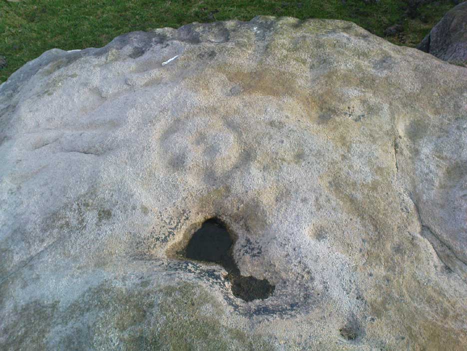
First described by Eric Cowling 1937, here we have what here looks like a faded cup-and-ring plus at least eight other cup-markings near Snowden Crags (though Boughey & Vickerman [2003] counted only 6 cups here).  In more recent years it has become known as the “Fence Stone” due to its proximity the straight line of fencing which ran across the moor hereby.  Cowling’s description of the site told:

Faded cup-and-ring
Cowling’s 1937 drawing

“The spur of hill separating Snowden Carr from Snowden Craggs is surmounted by a D-shaped enclosure which has a small level area in the highest corner.  Here, on a triangular table stone amongst the heather, is a well-cut cup, ring and radial groove running to the margin of the surface.  Four other cups appear to have no definite arrangement.”

He went onto say that “many of the boulders which surround this table are marked with cups.”  They are indeed!

References:

  1. Boughey, Keith & Vickerman, E.A., Prehistoric Rock Art of the West Riding, WYAS 2003.
  2. Cowling, Eric T., “Cup and Ring Markings to the North of Otley,” in Yorkshire Archaeological Journal, part 131, 33:3, 1937.
  3. Cowling, Eric T., Rombald’s Way: A Prehistory of Mid-Wharfedale, William Walker: Otley 1946.

Acknowledgements:  A huge thanks to James Elkington for use of his photo for this site profile.

© Paul Bennett, The Northern Antiquarian

Skirtful of Stones, Horton-in-Ribblesdale, North Yorkshire

Cairn (destroyed):  OS Grid Reference – SD 785 747

Getting Here

Although apparently long gone, we could find this giant prehistoric tomb on the eastern side of the great Ingleborough and was one of many with this name once scattering the mid-Pennines. It was found less than a mile south of the hamlet of Selside, a few miles above Horton-in-Ribblesdale, on the west side of the B6479 and its existence is thankfully preserved in the place-name, ‘Borrens’, where the giant tomb was once found, 200 yards south of Gill Garth Farm.  If you look on the OS-map, you’ll notice an ancient settlement site close by.

Archaeology & History

In 1892, the great Yorkshire historian Harry Speight told us:

“We have no proper account of it, but it was doubtless ransacked and removed in the expectation of finding treasure. It is mentioned…in the Gentleman’s Magazine for 1761, as follows:

‘In the valley above Horton, near the base of this mountain (Ingleborough), I observed a large heap or pile of greet-stones all thrown promiscuously together, without any appearance of building or workmanship, which yet cannot be reasonably thought to be the work of Nature. Few stones are found near it, though ’tis computed to contain 400 of that country cart-loads of stones, or upwards. There is likewise another at the base north-east, in resemblance much the same, but scarce so large.'”

Speight speculated that it may have been raised to commemorate “some dire conflict between the Romans and the native hill tribes, as it lay on the old Roman thoroughfare across Ribblehead to the camp under Smearside.” We may never know this for sure, but there are plenty of Iron- and Bronze Age remains scattering this region – and just a few hundred yards south of this lost cairn are the old remnants of an ancient settlement…whose pages and images (it is hoped) will appear on TNA in the near future…

References:

  1. Smith, A.H., English Place-Name Elements, volume 1, Cambridge University Press 1956.
  2. Smith, A.H., Place-Names of the West Riding, volume 6, Cambridge University Press 1961.
  3. Speight, Harry, The Craven and Northwest Yorkshire Highlands, Elliott Stock: London 1892.

© Paul Bennett,  The Northern Antiquarian