If you wanna drive here, be prepared for a long uphill winding haul, with very poor turning, single-track roads and no parking spots. It’s dodgy as hell! But, if y’ must – from the central roundabout in Todmorden, take the road diagonally across as if you’re going to the train station, and barely 50 yards up, take the right turn under the railways arches, bearing sharp left, then up the very steep zigzagging dangerous road for a mile or so. You’ll eventually reach Stones Lane on your left. Go down this, nearly to the end, slowly – and keep your eyes peeled until you see the big one! You can’t miss it! If you want walk up (a much safer, healthier and preferable route), take the Calderdale Way route up past Dobroyd Castle, and where you get to the top of the hill and the fields open up ahead of you, look down the slope into the field for one stone, and up past the shrubs to Centre Hill. You can’t miss them!
Archaeology & History
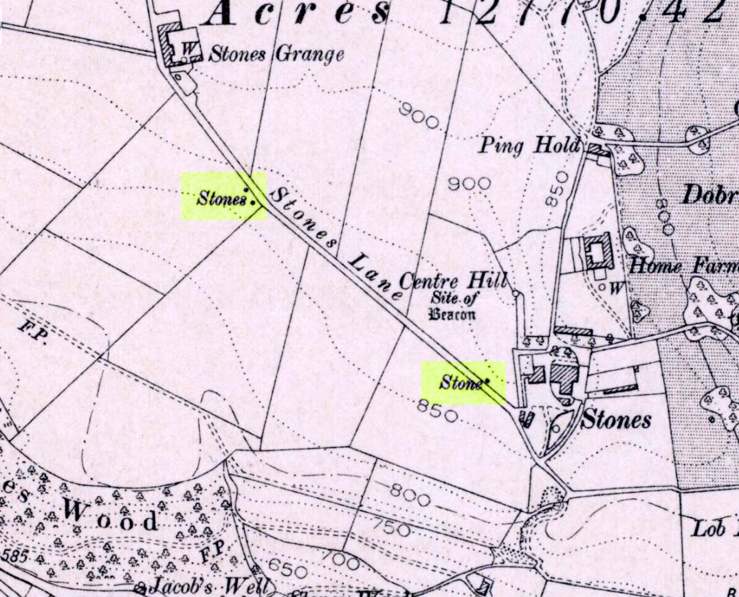
Three ‘stones’ on 1911 map
This is a quite extraordinary sight to those who visit here for the first time. Moreso because, until very recently, the place was excluded from all text-books and surveys. But if you like your megaliths, this place is well worth the trek up the hill. You’ll be amazed! The tallest and largest of these giant monoliths was recorded when a team from Ordnance Survey mapped the area in 1844, but gave no antiquated note to it. When another Ordnance Survey team re-surveyed the area again in 1911, they noted two other ‘stones’ three fields away to the northeast. More than a decade later, the industrialist historian Abraham Newall (1925) described them at some length in his fine work on the region.
Stone 1, looking NWStone 2, at top of hillock (soz about the crap picture)
The first thing generally noticed is the 12-foot tall standing stone near the bottom of the field (stone 1). Then you’ll see the curiously-worked thin standing stone, nearly as tall, on the hillock at the top of the same field (stone 2). This stone has been surmounted onto an old millstone and the hillock itself was once an old beacon hill. Then on the other side of the road a few hundred yards along, another stone just over 4-feet tall can be seen (stone 3); and in the same field is another one laid down at the side of a well (stone 4). This stone used to stand just where the water appears. It’s seems probable that other standing stones may once have been in close attendance, but have been destroyed over time.
Stone 3, looking southStone 3, looking west
Stone 1 is hemmed in at the base by several stones, giving the impression that it was resurrected at some time in the recent past. Several local stories attest to this. Stone 2 was once further down in the same field but was moved to its present position in the 19th century and was, it is alleged, moved there to commemorate the Battle of Waterloo. Several local historians contest this. Stone 3 has nothing said of it; apart from by the local farmer who said it once had a companion (as illustrated on the early map, above). We were told that this companion (stone 4) was uprooted and a spring of water appeared where it stood, so they laid it down in the position it still occupies, just by the spring 10 yards into the field.
If you’re into megaliths and live in Yorkshire or Lancashire, check these beauties out! Just respect the local farmer – he’s not into ignorant tourists clambering over walls. (don’t say you’ve not been warned!)
References:
Bennett, Paul, The Old Stones of Elmet, Capall Bann: Milverton 2001.
Newell, Abraham, A Hillside View of Industrial History, J. Bentley: Todmorden 1925.
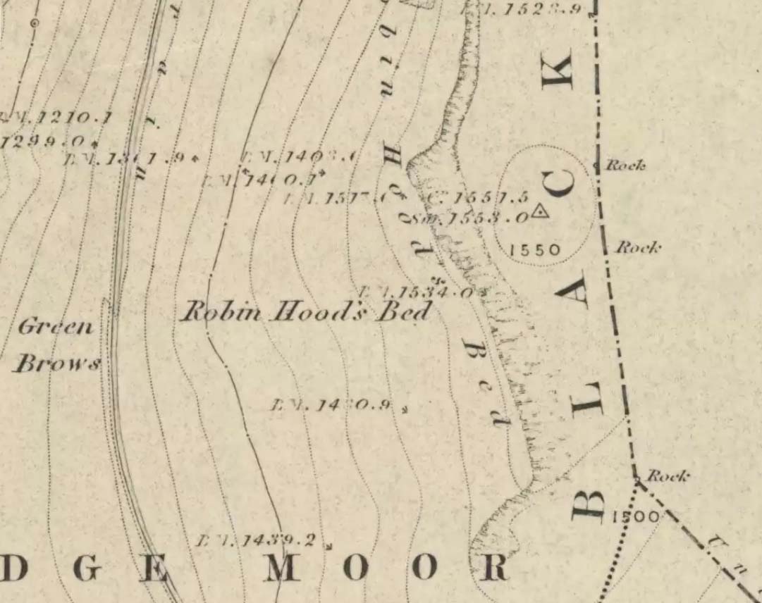
Follow the same directions to get to the Aiggin Stone. Once here, go over the stile by the fence opposite towards the great geological ridge less than half-a-mile south. Head for the triangulation pillar right on the top of the ridge, and there, about 20 yards past it, higher-up than the triangulation pillar at the very top of Blackstone Edge, is Robin Hood’s legendary stone bed!
Archaeology & History
Robin Hoods Bed, looking north
There’s very little of archaeological interest known up here, save a mass of flints and scrapers that have been found scattering the moorland heights hereby, from the mesolithic period onwards. But we have a relative lack of neolithic to Iron Age remains — officially anyhow! A possible standing stone can be found a few hundred yards south, but there’s little else.
The rock that’s given its name to Robin Hood’s Bed overlooks the very edge of the ridge, detached from the main section, with a large and very curious nature-worn ‘bed’ on its very crown, more than 4 feet wide and about 7 feet long, into which one comfortably lays. It was named in the boundary records of the township of Rishworth in 1836, where it describes other historical stones, saying:
“thence under Robin Hood’s Bed to a stone marked ‘W.S.G.S. 1742, 1770, 1792, and the following figures and letters, ‘1826 I.L.S.'”
Folklore
This enormous millstone grit boulder, sitting 1550 feet upon the high moors is, according to legend, a place where our famous legendary outlaw once slept. Whilst sleeping here, some of his followers were said to have kept guard and looked over him.
Robin Hood’s Bed, from below
A rather odd piece of folklore recited by Jessica Lofthouse (1976) is that “no winds ever blow” at Robin Hood’s Bed, who then went on to tell of the time she visited the place. Walking along the rocky ridge where the stone bed is found, the winds were such that “we had almost been blown over the edge,” until just a few hundred yards further when they eventually reached the fabled site, Nature granted them a sudden calmness unknown to all the high moorlands around, affirming the curious folklore.
The ceremonial stone ‘bed’
Robin Hood’s Bed itself was undeniably an important ceremonial site for both rites of passage and ritual magick to our indigenous ancestors. The place screams of it! It also seems very likely that the hero figure of Robin Hood replaced an earlier mythological character, akin to the fabled female creation deity, the cailleach, found commonly in more northern and Irish climes, whose echoes can still be found around our Pennine hills. For we find that Robin Hood was said to have taken a large boulder from here and with a mighty heave threw it six miles across the landscape due west into the setting sun, where it eventually landed at Monstone Edge, near Rochdale! Local people were so astounded at this feat that the stone was given the name of Robin Hood’s Quoit.
7ft tall natural standing stone
The old place-name authority Eilert Ekwall (1922) related the folklore that the giant ridge of Blackstone Edge “is said to refer to a boundary stone between Yorkshire and Lancashire.” Which may be the curious upright standing stone, more than 7 feet tall, less than 50 yards NNE which gives a very distinct impression of having been deliberately stood upright, amidst this mass of loose geological droppings! It would be helpful if there was a geologist in the house who could tell us decisively one way or the other…
Another etymological possibility that has been posited relates to the word ‘bed’ at this site. Ordinarily it would be sensible to attach the word to the great stone ‘bed’ atop of the poised boulder. But with the attached legends symptomatic of prehistoric monuments, it would not be improper to highlight that the old Welsh word ‘bedd‘ (a place-name element that is not uncommon in Lancashire) means, “a grave or tomb”. And this site would be ideal for such an old prehistoric cairn…
References:
Bennett, Paul, The Old Stones of Elmet, Capall Bann: Milverton 2001.
Ekwall, E., The Place-Names of Lancashire, Manchester University Press 1922.
Lofthouse, Jessica, North Country Folklore, Hale: London 1976.
Smith, A.H., The Place-Names of the West Riding of Yorkshire – volume 3, Cambridge University Press 1961.
From the lovely village of Summerbridge (near Pateley Bridge), go up the steep Hartwith Bank road, going straight across at the crossroads for another few hundred yards, passing the old tombs of Graffa Plain on your right…and they’ll start appearing on your left-hand side (west). Do not go into the expensive National Trust car-park. Instead (if you’ve already gone too far), about 100 yards before the Car Park you’ll find a small dirt-track on your left a short distance away. But if you drive past the rip-off car park, another 100 yards on there’s another spot where you can easily park up on the right-hand side of the road. Then cross the road and follow y’ nose…
Archaeology & History
The OS grid reference given above is an approximation — for obvious reasons. This is a huge area that’s covered by Britain’s finest natural megalithic features, obviously sculptured by Nature Herself — though many are the historians who sought to give Druids the credit here. God knows how! The area over which these magnificent rock sentinels live covers some 60 acres and is some 1000 feet above sea level. The view from the hill around which the encircling parade of rocks guards is excellent, allowing our eyes to catch focus on the distant lands of Whernside, Simon’s Seat, York Minster, the Cleveland Hills and Kilburn’s white horse. It’s quite a view.
Easternmost Rocking StoneIdol Stone (Godfrey Higgins 1826)
But this tends to be overlooked when you first visit the place, as the rocks which surround and walk alongside you overwhelm with impressions not encountered before. To those with spirit, you’ll be bouncing and running all day here, clambering upon rocking stones, jumping between dodgy gorges that await falls, and just aching to climb pinnacles that deny you. But then, if you need the selfishness of silence, this arena will only grant such solace when the rains are about, or dense fog and low cloud keeps others from this haunting amphitheatre. And it’s not surprising… The mass of rocks contort into the most beautiful and curious simulacra, which would not have gone unnoticed, nor deemed unimportant in the sacred landscape of our ancestors…
Brimham Rocks have been written about since the 17th century, though they didn’t receive the serious attention of outsiders until the 19th, when numerous Victorian writers — from antiquarians and geologists, to archaeologists and Druids — got to hear about the place. And by the beginning of the 20th century, a veritable mass of articles had been written in journals and travelogues of all persuasions! These quiet Yorkshire Rocks had become truly famous!
Brimham Rocks (Walbran 1856)Old Woman and her consort
A lengthy essay was written in the distinguished archaeology journal of its time, Archaeologia, by northern historian Hayman Rooke (1787), who thought that some of the rocks here had been tampered with by the druids; with the legendary Cannon Rock in particular possessing oracular properties. The site as a whole was, he posited, a temple for Druids in ancient days. Certainly the place would have been deemed as sacred, whether by the druids or our more remote neolithic and Bronze Age ancestors.
Harry Speight & his mates, c.1890
In Harry Speight’s magnum opus, Nidderdale (1894), he described these rocky giants as best as he could, admitting as others before and since, that no mere words can convey the impression that only a personal encounter liberates, saying:
“The Brimham Rocks are among the greatest natural wonders of Yorkshire, and many have been the theories from time to time advanced as to the cause of their extraordinary aspects… The resemblances to natural and artificial objects are most striking. There we have the Elephant Rock, the Porpoise Head, the Dancing Bear (a very singular, naturally-shaped specimen), the Boat Rock, showing the bow and stern completely, etc. Then there is the great Idol Rock, a most mysterious-looking object, of almost incredible size and form. It is a perfectly detached block, fully twenty feet high, weathered along face joints into three roughly circular pieces, each from 40 to 50 feet in circumference, piled one above the other; the whole mass, weighing by estimation over 200 tons, being poised on a pyramid 3½ feet in diameter; the pivot itself supporting this immense column having a diameter of barely 12 inches.
“East of the guide’s house are the famous Rocking Stones, consisting of a group of four rocks, which were discovered to be movable in the year 1786. The two on the west side weighing approximately 50 and 25 tons, require but little force to vibrate, while those on the east side, though much smaller are not so well poised and do not move readily. Each of the larger stones has a basin-like cavity on the top, and a kind of knee-hole open to the north, said to be the work of Druids. Close to the Rocking Stones are the appropriately-named Oyster-shell Rock, and the Hippopotamus’ Head. Turning now some thirty yards north of the Idol Rock we ascend Mount Delectable, where is the agreeable Courting or Kissing Chair, happily at not too close quarters with the above Hippopotamus’ Head and Boar’s Snout. The Chair consists of a single seat, but why it should be so called, I had better leave the amorous lover to solve. West of these is the more sober Druid’s Reading Desk, with its church-like lectern on a stout stone base. The we come to the Lover’s Leap, a gigantic and abrupt face of beetling crag, weathered to the west, and rising to a height of 60 to 70 feet, with three immense fragments balanced in a very remarkable manner at the summit. The rock is in tow principal sections, and an iron hand-rail has been fixed across the chasm to enable visitors to look down from the top. Further south are the Frog and Tortoise Rocks, the latter presenting from one point of view a capital resemblance to a tortoise creeping up the face of the crag towards the imaged frog. A little below this is a good imitation of a cannon, projecting from the edge of the cliff. In addition to these singular resemblances there are many others which the guide points out, such as the Yoke of Oxen, Mushroom Rocks, Druid’s Oven, Dog’s Head, Telescope, and the curiously perforated Cannon Rock, etc.”
In a later work, Speight (1906) also mentioned the existence of a Druid’s Circle some 300 yards west of the main natural temples, but this site appears to have been destroyed. Thankfully the large standing stone on Hartwith Moor, a mile to the south, can still be found upright…
Folklore
Idol Stone (Hargrove 1809)
In folklore, there’s little surprise this place was held by just about every 18th and 19th century historian as a ‘druidic site.’ But more interesting – in the light of Paul Devereux’s (2001) work on acoustic archaeology – is what Edmund Bogg (c.1895) said of these huge contorted stones:
“In bygone days these immense stones were supposed to be the habitation of spirits. The echo given from the rocks was said to be the voice of the spirit who dwelt there, and which the people named the Son of the Rocks. From a conversation we had with the peasantry not far from here, it seems the ancient superstition had not yet fully disappeared.”
This is precisely the notion of spirit given to rocky places elsewhere in the world, where the very echo was perceived as the ‘voice of the rocks’. Meditate on it a bit, in situ. (a fine summary of this notion and its implications — which has crept into archaeology of late — can be found in Paul Devereux’s work, Stone Age Soundtracks)
One of Brimham’s southwestern rocks was known as the Noon Stone when Mr Rooke (1787) came here. There are many stones with this name scattering Yorkshire and other northern counties, each with the same mythic background: that the sun casts a shadow from it at midday to indicate the time of day. Of this Noon Stone Mr Hooke also told us that,
“On Midsummer Eve fires are lighted on the side. Its situation is apposite for this purpose, being on the edge of a hill, commanding an extensive view. This custom is of the most remote antiquity.”
On the very southern edge of Brimham’s Rocks (some might say beyond their real border) is the Beacon Rock — and it is aptly named: as in the year 1887 on the day of Queen Victoria’s Jubilee, a great beacon fire was lit here, signalling to others in the distance. Its title however, pre-dates Victoria’s Jubilee, though we don’t know how far back in time it goes…
…to be continued…
References:
Bogg, Edmund, From Eden Vale to the Plains of York, James Miles: Leeds c.1895.
Devereux, Paul, Stone Age Soundtracks: The Acoustic Archaeology of Ancient Sites, Vega: London 2001.
Grainge, William, The History and Topography of Harrogate and the Forest of Knaresborough, John Russell Smith: London 1871.
Harrison, William, A Descriptive Account of Brimham Rocks in the West Riding of Yorkshire, A. Johnson: Ripon 1846.
Michell, John, The Earth Spirit: Its Ways, Shrines and Mysteries, Thames & Hudson: London 1975.
Michell, John, Simulacra, Thames & Hudson: London 1979.
Rooke, Hayman, “Some Account of the Brimham Rocks in Yorkshire,” in Archaeologia journal, volume 8, 1787.
Speight, Harry, Nidderdale and the Garden of the Nidd, Elliot Stock: London 1894.
Speight, Harry, Upper Nidderdale, with the Forest of Knaresborough, Elliot Stock: London 1906.
Walbran, John Richard, A Guide to Ripon, Fountains Abbey, Harrogate, Bolton Abbey, etc, Johnson: Ripon 1856.
Follow the same directions to find the Blackheath Circle, but instead of turning onto the golf course, keep going up the steep road until you reach the T-junction at the top; then turn left and go along the road for about 200 yards, past the second track on the left, keeping your eyes peeled across the small moorland to your left where you can see the rocks rising up. Walk along the footpath towards them. You can’t really miss the place!
Archaeology & History
The Bride at sunset – the fallen Groom to her left
If you’re a heathen or geologist and you aint seen this place, check it out – you won’t be disappointed! First mentioned in 1491, this has always been a place of some repute. Its legendary companion, the ‘Groom’, lays resting on the Earth after being felled sometime in the 17th century.
F.A. Leyland’s 1860s drawing
A beautiful, remarkable and powerful site of obvious veneration. First described in local deeds as early as 1491, there are a great number of severely weathered boulders all round here, many like frozen rock giants haunting a magickal landscape. The modern lore ascribes the stones to be dedicated to Bride, goddess of the Brigantian people. And like Her legendary triple-aspect, we find here in the landscape a triple aspect to the outcrops themselves: to the west are the Bride Stones; to the east, the Little Bride Stones; with the Great Bride Stones as the central group, surveying everything around here.
At the main complex is what is singularly known as the Bride itself: a great smooth upright pillar of stone fourteen feet tall and nine feet wide at the top, yet only about two feet wide near its base, seemingly defying natural law. Watson (1775) described, next to the Bride herself, “stood another large stone, called the Groom…(which) has been thrown down by the country people” – probably under order of the Church. Crossland (1902) told how the Bride also acquired the title, “T’ Bottle Neck,” because of the stone’s simulacrum of an upturned bottle.
The Bride & her Groom (laid on the earth)The ‘head’ or top of the Bride Stone
Scattered across the tops of the many rocks hereby are many “druid basins” as Harland and Wilkinson (1882) described them. Many of these are simply basins eroded over the millenia by the natural elements of wind and rain. It is possible that some of these basins were carved out by human hands, but it’s nigh on impossible to say for sure those that were and those that were not. If we could find a ring around at least one of them, it would help — but in all our searches all round here, we’ve yet to locate one complete cup-and-ring. So we must remain sceptical.
On the mundane etymological side of things, the excellent tract by F.A. Leyland (c.1867) suggested the Bride Stones actually had nothing to do with any goddess or heathenism, but derived simply from,
“the Anglo-Saxon adjective Βñáð, signifying broad, large, vast — hence the name of the three groups known as the Bride Stones. The name of The Groom, conferred on the prostrate remains, appears to have been suggested by the fanciful definition of the Saxon Brád, as given by (Watson).”
However, the modern place-name authority A.H. Smith (1963:3:174) says very simply that the name derives from “bryd, a bride.”
A “rude stone” was described in one tract as being a short distance below this great rock outcrop; it was turned into a cross by the local christian fanatics and moved a few hundred yards west, to a site that is now shown on modern OS-maps as the Mount Cross.
Folklore
Although local history records are silent over the ritual nature of these outcrops, tradition and folklore cited by the antiquarian Reverend John Watson (1775) tell them as a place of pagan worship. People were said to have married here, although whether such lore evolved from a misrepresentation of the title, Bride, is unsure. In the present day though there have been a number of people who have married here in recent years.
If the Brigantian goddess was venerated here, the date of the most active festivities would have been February 1-2, or Old Wives Feast day as it was known in the north. The modern witches Janet and Stewart Farrar, who wrote extensively about this deity (1987), said of Bride: “one is really speaking of the primordial Celtic Great Mother Herself,” i.e., the Earth Mother.
Telling of further lore, Watson said that weddings performed here in ages past stuck to an age-old tradition:
“during the ceremony, the groom stood by one of these pillars, and the bride by the other, the priests having their stations by the adjoining stones, the largest perhaps being appropriated to the arch-druid.”
New Age author Monica Sjoo felt the place “to have a special and uncanny power.” This almost understates the place: it is truly primal and possesses the virtues of strength, energy, birth and solace.
References:
Bennett, Paul, The Old Stones of Elmet, Capall Bann: Milverton 2001.
Crossland, Charles, “Place-Names in the Parish of Halifax in Relation to Surrounding Natural Features,” in Halifax Naturalist, volume 7, 1902.
Farrar, Janet & Stewart, The Witches’ Goddess, Hale: London 1987.
Harland, John & Wilkinson, T.T., Lancashire Folklore, John Heywood: Manchester 1882.
Leyland, F.A., The History and Antiquities of the Parish of Halifax, by the Reverend John Watson, M.A., R.Leyland: Halifax n.d. (c.1867).
Smith, A.H., The Place-Names of the West Riding of Yorkshire – volume 3, Cambridge University Press 1963.
Watson, John, The History and Antiquities of the Parish of Halifax, T. Lowndes: London 1775.
Go thru Killin and, just past the Bridge of Lochay hotel, take the tiny road on your left. Go down here for 3 miles till you pass the gorgeous Stag Cottage (with its superb cup-and-rings in the field across the road) for another 300 yards, past Duncroisk Farmhouse set back on your right, then over the small river bridge. Just over the bridge there’s a gate on your left. Go thru this and up the track until you get to another large gate. Go thru this, then walk immediately left where you’ll notice a large-ish boulder sat on the nearby slope ahead of you in a part of some very old walling. That’s your target!
Archaeology & History
The title of this carving is slightly misleading, as the stone concerned is about 50 yards west of the fast-running burn. But it’s pretty easy to locate. When we visited the stone recently, as the photos show, the rock was all-but covered in a beautiful patchwork of lichen and moss, inhibiting the visibility of a quite impressive carving. But we have to let this be.
The carving’s on the big rock by tree, in the wallingLine of walling clearly evident
The carved rock plays an important part in a line of ancient prehistoric walling, which looks Iron Age in nature, but without an excavation we’ll not know for certain. The walling is quite extensive and is an integral part of the extended derelict village of Tirai, with its standing stones and other monuments. This begs the questions: was the carving executed before or after the walling was created? Was the stone carved in traditional neolithic/Bronze Age periods and later accommodated into the walling?
Even in the grey overcast light of a winter’s day when we first visited here, many cups were clearly visible on the rock’s surface, but they were difficult to contextualize in terms of artificial and natural aspects of the stone. Later visits here at the end of Spring enabled a much better assessment — though capturing the surrounding “rings” proved difficult. The carving is shown highlighted on Ron Morris’ (1981) map of the cluster of Duncroisk carvings, and described as a:
“domed schist boulder, 2½m by 2m, 1¼m high (8ft x 6ft x 4ft). On its top, mostly where sloping…are: 2, and possibly 3, cups-and-one-ring, much weathered and only visible when wet in very low sun, probably un-gapped, and at least 32 cups. Diameters up to 17cm (6½in) and depths up to 1cm.”
But this is only half the story. Despite what Mr Morris and the more recent Canmore records tell us about this carving, there are in fact at least 52 cups on the surface of the rock, at least two of which have definite ring-like forms around them. The largest of the cups has linear features around a large section of it, but to ascribe these elements as ‘rings’ is also stretching it a bit — as one of the photos here clearly shows. The ‘ring’ consists more of two separate straight lines with curvaceous ends: more like a right-angled carving with a swerve than any traditional ring. It’s a quite unique feature by the look of things.
Faint cup-and-ring and cups…and…Cups & right-angled lines
The majority of the carved cups and lines occur on the eastern side of the boulder, with only a few singular cups almost fading their way onto its western sloping sides. And of primary visual interest are the swirl of cups that surround two small cups at the ESE corner of the rock. These give the impression of running into another swirl of cups that hedge their ways around the edges of the largest cup-and-right-angled-lines, until bending back up and along the southern-side of the stone. This possibly deliberate sequence of cups then continues in roughly the same form back upwards to near the top-middle of the rock and onto a complete cup-and-ring. Just above the top of this runs a short pecked line just detached from the cup-and-ring, but of obvious mythic relevance in the story which this carving once told.
RWB Morris’ sketch of the design
It’s an absolutely fascinating carving which gives the distinct impression of narrating a myth of journeying, by either a person, tribes or ancestral beings. Of course we’ll probably never know for sure what story it once told; but its tale may have been known by the people of the once proud village of Tirai which was only destroyed a couple of centuries ago, along whose fallen walls this great stone still rests within…
And finally, for those students exploring the potential relationship that cup-and-rings may have with water: please note that in wet conditions, a spring of water emerges right underneath the very base of this large rock.
…to be continued…
References:
Morris, Ronald W.B., The Prehistoric Rock Art of Southern Scotland, BAR 86: Oxford 1981.
Royal Commission on the Ancient & Historical Monuments of Scotland, Archaeological Sites and Monuments of Stirling District, Central Region, Society of Antiquaries of Scotland 1979.
If you follow the directions to reach the Churn Milk Joan stone, then continue onto the moor following the same directions to find the Miller’s Grave, once you’ve reach this you’ll see a large rounded boulder a couple of hundred yards away on your left, to the northwest. That’s Robin Hood’s Penny Stone!
Archaeology & History
Robin Hood’s Pennystone, Midgley Moor
In terms of this site’s archaeology, it has none to write home about in official records (other than a few flints found nearby), but there’s more to this place than meets the eye. A large rounded boulder sat upon the moorland plain with a large Nature-worn bowl on its top, the site is some 112 yards (102m) northwest of the little-known, but impressive Miller’s Grave prehistoric cairn (close to being a midsummer/midwinter line). North and south of the rock are small lines of prehistoric walling — though their context is difficult to assess. The Greenwood Stone and Greenwood B stone can be found about 200 yards west.
Folklore
A singular footpath once led up to this old boulder, atop of which – in its large ‘bowl’ – vinegar used to be poured. In this, coins were left by local people who suffered the plague and in return food was left for them. And of course it is said that Robin Hood frequented the place in bygone times.
References:
Bennett, Paul, The Old Stones of Elmet, Capall Bann: Milverton 2001.
Robert, Andy, “Our Last Meeting,” in NEM 37, 1989.
Robert, Andy, Ghosts and Legends of Yorkshire, Jarrold: Sheffield 1992.
Two real ways to get here. Either (i) follow the directions to get to the Stag Cottage carvings of Duncroisk 1, then walk down to the fence by the riverside and walk along to the left for a coupla hundred yards till you reach a second metal fence-post sticking out of a rock on the other side of the deer-fencing; or (ii) from the roadside burn a coupla hundred yards along the road before you reach Stag Cottage, follow it down to the riverside, then head along the footpath behind the fencing, parallel with the river’s edge. It aint far. Within 100 yards you’ll reach the stone with the metal pole sticking out of it and the carvings are on this!
Archaeology & History
Confusingly redesignated as Duncroisk 5 carving by the usually efficient Canmore people, we’re sticking with this stone’s original name given by Ronald Morris (1981) in his British Archaeological Report of this and nearby carvings — and a quite fascinating carving this is as well!
C.G. Cash’s drawingDuncroisk 3 stone
As with many cup-and-rings, erosion and lighting has a powerful effect on seeing the design correctly. On my visit here in recent months there were quite distinct additional elements in the carving which haven’t been noted by previous archaeologists. But in saying that, there were also some elements that were reported by the earliest antiquarians that proved difficult to see in the grey light of day when I was here. The earliest report of the carving by C.G. Cash (1912) told there to be five rings, whereas today only 3 or 4 are visible (though this will probably change when viewed in other lighting conditions).
When Mr Cash told of this stone in his essay on the antiquities of Killin it sounded as if it was lucky to have survived, as it had previously been dug out and left by the roadside, before then being reused by a local to fix a fence-post in! Mr Cash told us that the local,
“had used it as the foundation stone of the stretching post at the south end of the easternmost fence on the farm, and there I found it, near the brink of the river, buried in sand and turf. I cleared it and then in pouring rain crouched over it to make a hasty sketch. It bears eighteen cups, of which five are surrounded by rings. The largest cups are 2½ inches and the rings 6 inches in diameter.”
Ron Morris’ images
When I visited the place the weather was much the same as Mr Cash described: lovely teeming rain, typical of the mountains, with the surrounding trees breathing moisture onto the slopes as ever.
Years later when Ronald Morris (1981) came here he saw “4 cups-and-one-ring…probably complete rings, up to 12cm (5 in) in diameters and 10 cups up to 2cm deep.”
If you stand and face the stone, the cup-marking on its lower right side (see Morris’ old photo, above) has a pecked line running from it further to the right and down to the edge of the rock. You can clearly make it out on the top photo. This carved line also seemed to touch another carved line which can be seen running along the outer edge of the stone — although the poor light didn’t allow me to view this with absolute confidence. I’ll have another look at it again when I’m up in the area in May and hopefully confirm or deny it with greater confidence (and if anyone else gets here in the meantime, have a look and see what y’ think).
Get right to the top of the valley, past the end of the tree-line where the moor opens up ahead of you. Keep going till you reach the farmhouse on the left (there are usually sheepdogs outside, barking their heads off!). Take the track on the right, making sure y’ close the gate (the farmer here is infamous – so please shut the gate!). Cross the yummy stream at the bottom & double-back on y’self. If or when y’ reach the derelict house (an old shooting house), drop down the small valley, over the stream and stick to the bottom edge of the slope. (if y’ don’t reach the house, just cross the stream and keep to the contours) Keep walking for about 200 yards, keeping your eyes peeled for some uprights!
Archaeology & History
As with the Turvin Stone a half-mile southwest of here, this too is a very peculiar site. ‘Peculiar’ inasmuch as no-one really seems to be able to make head or tails what the place actually was. As you’re approaching the place, it looks like some decent ‘four-poster’ stone circle is ahead of you; but once you reach the place there are a veritable number of other earthfast rocks and tumbled stones all round, making your initial appraisal of the place suddenly grind to a halt! Added to this is the oddity of finding the standing stones on a considerable geological slope, unlike most other megalithic sites in the region (and elsewhere for that matter!).
The tallest standing stone
The tallest, easternmost of the three stones (SD 99547 21992) is more than five-feet tall and is lower down the slope than the other uprights here. Almost ‘surrounded’ by some denuded stone enclave (a large robbed cairn perhaps?), this is the most visually impressive of the stones here. Up the slope from here 15 yards (13.56m) away is what may, or may not, be a simple earthfast boulder (at SD 99535 21999): but it’s upright, about 3 feet tall, and due to proximity gives the impression that it was part of whatever monument this site once was. Due west of the tallest standing stone nearly 20 yards (17.6m) away, is a more rounded stone of ‘female’ character, less than 4 feet tall (at SD 99528 21993). That’s the general gist of the place.
If you visit here you’ll notice another smaller upright a short distance further down the slope in the green, less than three feet tall And there’s possibly another one of similar stature more than 200 yards SSE. But what is this place? Is it prehistoric? Was it built in the Dark Ages? Medieval times? Does anyone have a clue!?
References:
Bennett, Paul, The Old Stones of Elmet, Capall Bann: Milverton 2001.
Burl, Aubrey, Four Posters: Bronze Age Stone Circles of Western Europe, BAR 195: Oxford 1988.
From Mytholmroyd, take the Cragg Vale road (B6138) up and up and up, until you get past the tree-level and the hills open up on either side of you. Take note of the farmhouse on the right-hand side of the road a half-mile on and park where you can. Walk down the track by the farmhouse (known as Washfold Road) and cross the stream at the bottom. OK – from here walk straight up the hill in front of you! (not along the footpath) In less than 100 yards it levels out and you’re onto the moorland proper. From here walk straight west for about 400 yards. If you deviate a little, don’t worry. You’ll see this small upright stone as you’re getting closer, seemingly in line with several other rocks, almost giving the impression you’ve come across a stone row. Good luck!
Archaeology & History
The slim upright
This small squat standing stone is just over three feet tall (1m), about 10 inches thick and 3½-feet across. Leaning at an angle into the ground, this broad but thin monolith has sunk some distance into the moorland peat.
It was located on February 15, 2011, in the company of Dave Hazell (pacemaker in tow!) on our first sojourn of the year. It hasn’t been mentioned in any previous surveys and aint in anyway what you’d call impressive. Nearby are the early remains of old walling north, east and west of here (one of them being a small enclosure of some type), for which I can again find no other references. What looks distinctly like the remains of a large cairn isn’t far away either. However, it may be that some of the remains up here are medieval in nature and it would be of benefit if someone who specializes in remains from that period could have a look here. The equally curious Turley Holes standing stones can be seen a half-mile northeast of here.
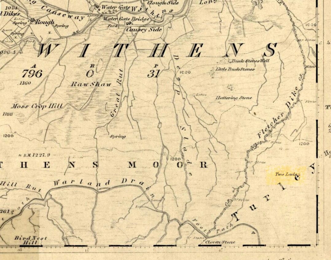
Best way here is, from Mytholmroyd go up the Cragg Vale road for a coupla miles, then turn right and heading down, then up, towards Withens Clough reservoir. Once there, walk onto the moor to your left (south) until you’re on the ridge above you. Keep walking until y’ see the rocky cairn-like creatures stood in isolation on a flat moorland plain.
Archaeology & History
Two Lads – on a dark, rainy, windy day
Truly weird spot this one, but I love it! Seemingly miles from anywhere, it’s one helluva walk to most folk, but utterly worthwhile when your arrive. On a clear day you can see for miles and the landscape is adorable! On a cloudy rainy day, the feel of the place changes if you take care to stay with the site, saturated, meditating (as no other people ever turn up when She’s like that – so you and the place get the best from each other!).
The site comprises of two boulders, each crowned with a cairn of stones. The westernmost one of the two (SD 98392 22111) is intriguing as it has, carved upon the rock beneath the stone cairn on the northwestern edge of the stone, what looks like a singular cup-marking, plus a large water-worn bowl on its northern edge, and a very distinct deeply-cut cross-base, several inches deep, near the northeastern corner of the rock. This cross-base seems slightly more rectangular in form than square; although the large covering of stones makes an accurate ascription difficult. If this cross-base and cup-markings are authentic, we would have here a clear example of the christianization of a previously heathen site.
A cursory examination of the easternmost of the Two Lads (SD 98397 22117) doesn’t indicate any artificial workings on the rock surface.
Two Lads on 1853 OS-map
Although the two ‘cairns’ on top of these two rocks are not prehistoric in nature, about 20 yards behind the Two Lads (south) may once have been the severely denuded remains of a once large prehistoric cairn. Although the position in the landscape is perfect for such a construction, this is somewhat tentative, it’s gotta be said! Further examinations are obviously necessary here.
The studious A.H. Smith (1961-63) believes that a field-name record from 1624, describing some ‘Lad Stones’ in the parish of Heptonstall relates to this site. We know with certainty however, that this site was first illustrated on Greenwood’s 1771 map of Yorkshire, then highlighted on more recent 19th century Ordnance Survey maps as ‘cairns.’
Folklore
Drawing of the Lads in 1877
The creation myth behind this place is that two lads were walking over the moor in midwinter and got caught in a blizzard. Losing all sense of visibility they tried to shelter from the wind and snow by hiding behind these rocks, but perished. Sometime later their bodies were found and the curious “cairn” of rocks were mounted onto the boulders to mark where they’d died. This is a folktale we find at many other old stone remains on the hilltops of northern England and Scotland.
The Two Lads seems to be very close to a midwinter alignment (or izzit a lunar standstill line?), linking it with the huge Rudstoop Standing Stone and, eventually, Robin Hood’s Penny Stone on Midgley Moor – which might be the root of the folktale. (i.e. midwinter, snow, death) Any archaeoastronomy buffs out there wanna check this one out? Then we can confirm or dismiss it.
References:
Anonymous, “The ‘Two Lads’, Withens Moor,” in Todmorden & Hebden Bridge Historical Almanack, T. Dawson: Todmorden 1877.
Bennett, Paul, The Old Stones of Elmet, Capall Bann: Milverton 2001.
Smith, A.H., The Place-Names of the West Riding of Yorkshire, Cambridge University Press 1961-63.


")


")


")