To search for any sites in the northern counties of England (previously known as Brigantia), click on the list of relevant counties, below. Please note that not all these english counties were truly in Brigantia, but they came close to its southern edges; and as parts of them tickle the edges of the southern Pennines, I thought they should be included. Hope that’s OK with everyone!
Cross (destroyed): OS Grid Reference – SK 2612 9417
Also Known as:
Hanson Cross
Archaeology & History
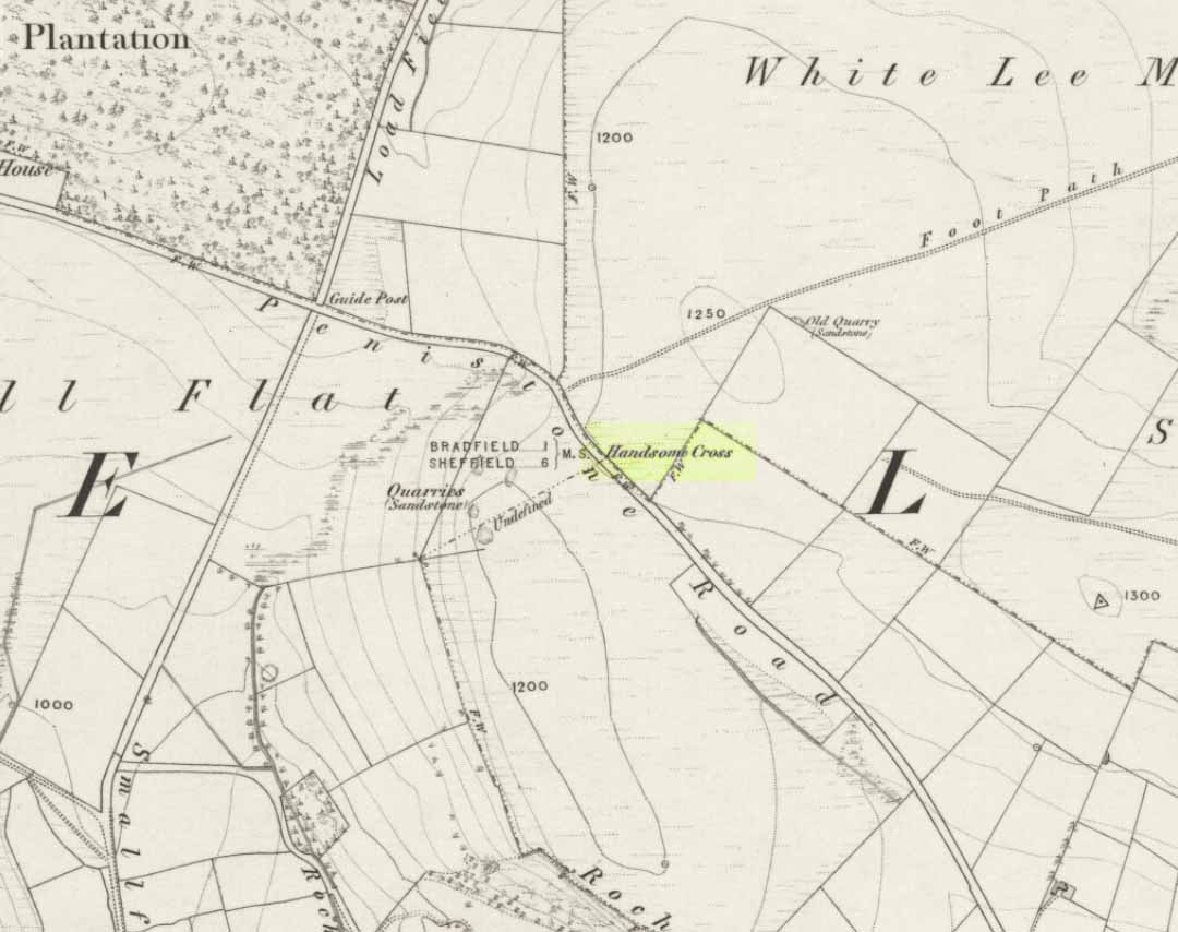
Handsome Cross on 1855 map
Described in Joseph Hunter’s (1819) rare work as being close to a now-lost stone circle, this wayside cross is shown on the earliest Ordnance Survey map of 1855 as being at the side of the old Penistone road, across from the guide-stoop which can still be seen. The cross stood at a peak on the roadside which allowed it to be visible from either direction and probably stood on the ancient township boundary line.
In Neville Sharpe’s (2002) fine survey he found an early account of this lost relic from writings ascribed to one John Wilson, who lived between 1719 and 1783, which told that,
“Ann Hawley, an old woman who lived at Broomhead in 1700, says she remembers Hanson Cross having a head and arms. The head is still there, but the arms I do not remember.”
References:
Hunter, Joseph, Hallamshire: The History and Topography of the Parish of Sheffield, Lackington: London 1819.
Sharpe, Neville T., Crosses of the Peak District, Landmark: Ashbourne 2002.
Smith, A.H., The Place-Names of the West Riding of Yorkshire– volume 1, Cambridge University Press 1961.
Park up at Cut Throat bridge on the A57 or alternatively at the huge parking area that’s signposted a little further uphill. Either way, the easiest access point is at Cut Throat Bridge – though be aware the route between the two areas is the narrow grassy verge of the road: take care, kids and dogs on a very short rein! There are many ways to access the circle but I’ll deal with only two here: one, a scramble up the steep bank of the edge; and the other, a longer route which takes in a quite a steep path, but is much easier than the first option if you’re not up for a scramble!
Route 1: The shorter scrambly route – Climb the stile into the wooded area & follow the path till your out of the wood, carry on for another 100 metres then head to your left & up the banking. The circle is thereabouts 40 metres onto the moor in the grassland, not the heather.
Route 2: The longer way but following a relatively easy path – Access the moor via the stile and just follow the path for around ½-mile till it veers to the left at Jarvis Clough & takes a steep route uphill. You then need to head left along the edge for around ¼-mile till you see the circle off to your right in the grassland.
Archaeology and History
Don’t let the bastardization of this site’s name fool you! The seven stones actually number between 9 and 24, depending on the season and the growth around them. They’re laid out in a rough free standing circle around 15.5 metres in diameter.
Hordron Edge looking across to Lose Hill
One of the largest stones to the SW is said to mimic the profile of Lose Hill — which it does sort of if you have a vivid imagination. But it’s not half as close as the top of the stone matches the profile of Lose hill off to your right. It is a complete coincidence of course. The stone has suffered much weathering over the millennia and I’m in no doubt it wasn’t an intended original feature. (see pic, right)
Previously, and at some time preceding the 1992 excavations at the site by John Barnatt, the circle was “tampered” with, leading to a thorough investigation that unearthed several more buried stones, one of which was re-erected.
All in all a fantastically preserved circle and one of the best examples in Derbyshire that’s well worth the effort of a visit. Watch the weather though; as on all but one of my visits I’ve been drenched!. The “wow” factor of this site however, makes that a small price to pay for such an awe-inspiring excursion. With Win Hill and Lose hill looming large to the southwest, Stanage Edge off to the southeast and the great outcrop of Ladybower Tor with it’s rock art to the west, this circle has some of the best scenery of any the circles in Derbyshire.
Folklore
The stone that alleges to line-up with Lose Hill is also known by some of the more imaginitive as the Fairy Stone and there have been reports of strange lights and other phenomena reported around it. I’ve been up here on probably a dozen occasions and never witnessed anything strange — but then I’m often accused of being closed-minded. Another way of saying “non gullible” in my book!
References:
Armitage, Harold, Early Man in Hallamshire, Sampson Low: London 1939.
Barnatt, John, Stone Circles of the Peak, Turnstone: London 1978.
Burl, Aubrey, The Stone Circles of Britain, Ireland and Brittany, Yale University Press 2000.
Thom, A., Thom, A.S. & Burl, Aubrey, Megalithic Rings, BAR 81: Oxford 1980.
Located just off Hathersage Road, by Parsons House outdoor pursuits centre with parking in a roadside layby. Don’t Park at Parsons House – they won’t like it! Head up the old road besides Parsons house and take the entrance onto the moor about 100 metres past the pursuits centre track. If memory serves me correct, it’s by the second wall on the right. Follow the post-and-mesh fence to the end of the wall and turn right, following the wall for around 70 metres down hill and you’ll be able to see the cairn’s bank before you in the heather. The stone pictured lays in the banking by the entrance which faces NNW.
History and Archaeology.
There’s no excavation taken place here that I know of, but the site is well known and mentioned in an old report I found Here. The article also contains an old map of the area showing the site.
Also mention is made of a stone referred to as the Fingeram stone. There is a stone laid flat in the position marked on the map, but I’m unsure whether it’s the standing stone mentioned. According to the old text the ring cairn has a diameter between 83ft and 95ft. Directly to the north and roughly 50 metres onto the moor, in line with the wall, is an interesting egg-shaped and weather-worn boulder that’s also worth a look at. This whole area is a sea of sandstone.
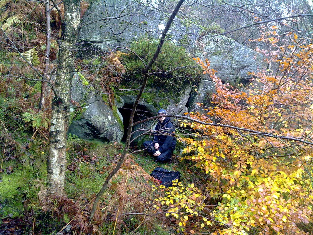
Park at Wyming Brook nature reserve car park off Redmires road and head off up the steps to the right of the notice board. Turn immediately right through the trees and you’ll soon pick up the path running along the ridge above Wyming Brook drive. Stay on the obvious path for around ½-mile passing “Big rock” to your right and the views it offers over Rivelin Valley and the dams. A short way further along the path steps down a couple of feet and turns to the right before straightening again, this is where you need to start looking down the edge to your right for a large rock that resembles a Chesterfield sofa which makes up part of the shelters roof.
Once you’ve located the site a short scramble will be needed to gain access to the entrance and this is where care is needed. It’s not difficult but has the potential to be deadly due to the steep nature of the edge so please take care and keep any kids on a very short rein.
Head down to the right of the “sofa” and jump down the 3ft drop holding onto the rather handy bracken and saplings if needed and the entrance is right there to your left.
Archaeology & History
Errr……..yeah, it’s history! — Well I’ve yet to find anyone else that actually knows about this cave, let alone it’s past! There are obviously locals who know of it’s existence but after half a dozen visits there I’ve not seen anyone except a brave old lady, 70 if-a-day, who was there looking for the supposed wartime carvings and that was on my first visit.
I have tried every possible avenue i know to reveal the caves past but as yet nothing, I’d be grateful if you could enlighten me at all.
I did e-mail John Barnatt with hope he’d have some information but alas no, though it is admittedly just outside his patch being on the Sheffield side of the Derbyshire / Sheffield border.
The shelters entrance is around 3ft high but once inside the roof quickly gains height and tops out at around 7ft so standing is easy. Beware half way along the interior by the small opening though — you’ll crack your head if your attention is drawn to the light beaming in through the side! There’s quite a bit of occupation rubbish within the cave due to someone making their home there: a sleeping bag, old tin cans, bottles, etc, is evidence enough, but the stuff’s quite old and no one resides their now.
“X” marks the spot!
At the far end of the shelter is a small chimney like opening and it’s just possible to squeeze between the fallen rocks and make your way out, it would also make an excellent outlet for smoke if you chose to have a warming fire inside.
You probably won’t notice on your way in but coming out and on the rocks by the entrance to your left are carvings dated to 1944 said to have been inscribed by German prisoners of war held in the area but I’ve yet to substantiate that.
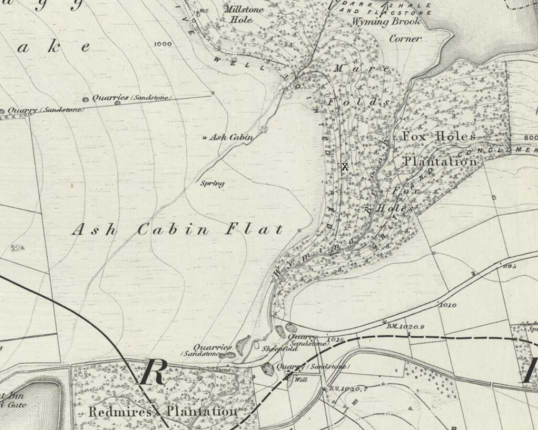
Despite a footpath being marked on the OS map, there’s none I could find and the only way to get there is to make your way through the heather. Park at the Wyming Brook nature reserve car park on Redmires road, take the signposted path besides the notice board and follow the line of the dry stone wall. Go through the gate and continue till you come to the end of the wall where a path leads off to your left through the broken wall, follow the path through the boggy bit and head uphill till you get to the highest point of the path by another wall with a path the other side. From here it gets a little tricky! You’ll now need to go off path heading NNE and down hill till you come to the post-and-wire fencing where you should pick up a slight path heading WNW (your left) and head for the high point about half a mile in front of you. Just before you come to the high point you’ll have to cross the stream (easily done). The cist lays on the flat ground just beyond the brow of the rise.
Archaeology & History
A long cist around 3 feet wide and 6 feet long in a well preserved condition aligned almost — but not quite — East/West on a prominent position on Hallam Moor, commanding views over Ash Cabin flat, Rivelin Valley and the A57 road. The only restricted view is to the northwest, where the moor rises then drops down again towards the Headstone.
There are 3 side-stones still in situ: the largest around 1 metre tall, the others still in place being about 70cm. The stones that would have made up the rest of the walls lay close by.
When you’re at the site it’s obvious why it’s in this location: the views are spectacular and afford excellent views of the surrounding area. A burial site with a vista truly fit for a king!
Archaeologically there’s not much info kicking around that I can find and I’m indebted to Stubob for alerting me to it’s presence. It’s very unlikely you’d be walking this area for any reason other than to visit the site, as there are decent paths across the moor to the most popular site in this area, the Headstone off to the North West. Remains of the Ash Cabin Flat stone circle are about 750 yards southeast of here.
A real gem of a site and a “must see” if your in the area.
Follow Redmires road till you come to Wyming brook nature reserve and use the free parking facilities there. From the car park you need the signposted path to the right of the notice board, the first one not the one by the metal barrier; climb the rocky steps and follow the line of the dry stone wall to your left, and after around 50 metres you’ll pass through a wooden gate. You then continue following the wall as it heads downhill and the wall becomes broken. Here you should notice a path that goes through the broken wall off to your left: don’t take it but continue another 50 metres or so, then turn 90° to your right facing the moorland. The circle is around 50 metres into the heather.
Ash Cabin Flat Stone Circle – as of 26/5/09
Archaeology & History
A fairly well preserved late neolithic or early Bronze age embanked stone circle located in a sea of heather on Ash Cabin Flat on the Western outskirts of Sheffield and rediscovered in 1981 due to the moor being burnt back.
The site is oval in shape and around 9m x 7m diameter to the outer edge of the bank. The banking is well preserved and shows there was no entrance to the interior.
There are around a dozen stones within and on top of the bank but it’s uncertain whether they are circle stones or packing stones from the bank. English Heritage have recorded 5 of the stones, 2 still standing, as stones that once stood making up the circle.
If you visit any time soon (23/11/09) you’ll find the moor has been burnt back again giving an excellent view of the site, when the heather is in full flow it’s as high as the highest stones making not only finding the circle nigh on impossible to find but also defining the site very difficult.
Additional Notes:
Editor – 1.12.9. – Following a visit to this site in the company of Megadread recently, we found what appears to be a number of other cairns on the flat moorland plain around this seeming cairn-circle site. There also appeared to be distinct evidence of ancient walling. Further archaeological evaluations are required here.
References:
Burl, Aubrey, The Stone Circles of Britain, Ireland and Brittany, Yale University Press 2000.
Take the road from Masham into this lovely hamlet and, as you reach the staggered crossroads, you’ll see a small village green with a single tree at where the four roads meet. In the grass below the tree is this forgotten monument!
Archaeology & History
Fearby Cross remains
Found at the meeting point of five old lanes, little has been written about the old cross remnants here, which is barely a foot high and rests on its roughly circular stone base. It sits where five old tracks meet and is thought to be medieval in origin. Speculation alone pronounces the site to have been a place where local council proclamations occurred, and where funerals stopped and the dead were rested.
One intriguing piece of information narrated by Edmund Bogg (1906) that may have had some relevance to the siting of this old cross, told that between here and the hamlet of Healey a mile west,
“there were formerly circles of upright stones and other relics suggestive of druidical origin.”
Any historical information or folklore relating to these apparent megalithic remains needs to be uncovered!
References:
Bogg, Edmund, Richmondshire and the Vale of Mowbray, James Miles: Leeds 1906.
Easy to locate: it’s just by the roadside on the left-hand side of the road, Jinny Lane, coming out of the village, just after the last house where the field begins.
Archaeology & History
Nowt to write home about, as they say. The waters here trickle from the earth into an old stone trough — but they don’t look too appetizing (even I didn’t have a drink, which is something of a rarity!). Its the folktale accompanying this little site, giving a distinct hint of some heathen past, that I found intriguing.
Folklore
Here was once the spirit of a woman called Jinny – who gave her name to the road it’s on – that wandered betwixt the well and an old stone, once found further up the hillside (after a bitta digging, we found the remains of the old stone, previously an authentic monolith). It was said that if you wandered along the road on certain moonlit nights, her spirit would chase you. To make matters worse, the ghost was a headless one!
Jinny’s spirit originally resided, peacefully, in the broken old stone atop of the hill. At a certain time of the year, the spirit of the stone would venture downhill to drink from the waters here (much as we find at Rollright and other places). But one day a xtian priest came along and, because of its heathen association, broke the old stone in half and cursed the spirit which roamed between the sites. Thereafter, Jinny’s ghost wandered in torment, with her head hacked off, scaring people half to death when they saw her. And so, another priest was eventually called who, to the satisfaction of local people, eventually put Jinny’s ghost to rest, as they say. It seems to have been a successful ritual, as no-one has reporting seeing the headless ghost for many a long year.
References:
Byrne, Clifford H., Newchurch-in-Pendle: Folklore, Fact and Fiction, Marsden Antiquarians: Nelson 1982.
This site can be reached with relative ease from Colne’s train station by crossing the road and going up Bridge Street, turning immediately left along Shaw Street for several hundred yards until you reach Waterside Road on your left-hand side. From here, as Mr Tom Sharples told, “St. Helen’s Well is presently within the area of overgrown and unmanaged scrub woodland adjacent to Waterside Road.” Look around!
Archaeology & History
First described on the Megalithic Portal by the pseudonymous Brionnfhionn, this recently rediscovered holy well can be found on the southern side of Colne, at Waterside. A few months after the MegPortal announcement, a more detailed overview of the site was published on GoogleDocs, from where Mr Tom Sharples has kindly allowed us to repeat the information that both he and Susan Bryant-Lauder compiled there.
The site was relocated after reference had been found in Geoff Crambie’s (1978) A Colne Festival, where he wrote:
“1935 saw the end of St. Helen’s Mill in Waterside. Built by Nicholas England in 1835, it was named after the St. Helen’s Well nearby, which was reputed to have been named by the Romans.”
The local writer Dorothy Harrison (1988) also mentioned the site, though only in passing, when she told,
“Along with St. Helen’s Well, Buck Spout provided the main source of drinking water in Waterside.”
There has to be some more information about this little-known site hidden in some old Lancastrian history or folklore work, somewhere – surely!?
References:
Crambie, Geoff, A Colne Festival, Turner & Earnshaw: 1978.
Harrison, Dorothy (ed.), The History of Colne, Pendle Heritage Centre 1988.
Head up to Rivock’s Wondjina Stone carving, then keep going east to the Long Rock. Wander 100 or more further east till you see the fence, and about 50 yards before this check out the large rocks which you’ll notice near to each other. One of them is this Split Rock!
Archaeology & History
First described in Hedges’ (1986) survey, this is a large flattish boulder, split across one side, with two distinct cup-marks on its eastern side and a number of other ‘possibles’ scattering the surface. The most intriguing bit to this rock is on its lower eastern side. Here’s what Boughey & Vickerman (2003) described as,
Deep cup-and-half-ring
“one clear cup (doubtful) discovered under turf…at extreme lower SE corner, with possible attempt at pecked partial ring.”
This cup they describe as “doubtful” is quite deep, but the half-ring on its northern side has definite artificial peck-marks. I’m more of the opinion that this cup-and-half-ring is man-made — though whether it was done in more recent years is the more debatable aspect here. I’ll try getting some better images (and a drawing) of this stone when we’re next up here.
References:
Boughey, Keith & Vickerman, E.A., Prehistoric Rock Art of the West Riding, West Yorkshire Archaeology Service 2003.
Hedges, John, The Carved Rocks on Rombalds Moor, WYMCC: Wakefield 1986.