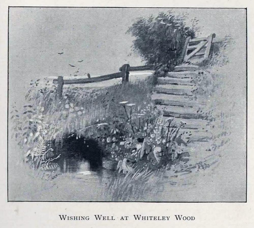
The location of this site has proved troublesome. Even when Rob Wilson (1991) did his local survey of holy wells he was unable to locate it—but it looks as if it shouldn’t be too troublesome to find, as the area in which it flowed is still very much a mix of open countryside and maintained landscapes. Described briefly as the “Wishing Well near Whiteley Wood” in Sidney Addy’s (1893) fine work, he makes a rather hopeful attempt to derive the word ‘wishing’ from German mythology, where “one of the names of the god Wuotan or Odin was Wunsch or Wish.” But – well – you just never know…..
In the landscape at Whiteley Wood there is a Priest’s Hill, so if this Well was found there, it may indeed have had an authentic ‘holy’ designation. But there were a couple of ponds in the area too, which may be fed by this spring. So, first, we need to find the well!
References:
Addy, Sidney Oldall, The Hall of Waltheof, William Townsend: Sheffield 1893.
Wilson, Rob, Holy Wells and Spas of South Yorkshire, Northern Arts: Sheffield 1991.
The well can be reached along a narrow country lane to the east of the A6 road, some 3-4 miles north of Preston. Fernyhalgh is a tiny hamlet between the villages of Broughton and Grimsargh with pleasent countryside on all sides. The holy well of Our Lady is in the garden of a house with a Roman Catholic chapel and pilgrimage centre at the side of a secluded country lane; entrance through a little gate.
Archaeology & History
Our Ladys Well, Fernyhalgh
There was a chapel on this site way back in 1348, and the spring itself is obviously a pre-Christian one with its dedication to Our Lady – St Mary the Virgin. According to the legend, in about 1471 a merchant sailing across the Irish sea was caught in a terrible storm; afraid that he was going to drown he prayed to the Virgin Mary and vowed that if his life was saved he would undertake some work of devotion to her. Soon the storm cleared and he found himself washed-up but safe on the Lancashire coast but he himself had no idea where he was. At that moment a heavenly voice spoke to him and told him to find a place called Fernyhalgh and there build a chapel at a spot where a crab-apple tree grew – the fruit of which had no cores, and where a spring would be found. He began to search around for this sacred place but no matter how much he tried he could not find the place.
The merchant found lodgings in Preston and, was about to give up altogether, when he overheard a serving girl at the inn. She started to explain why she was so late on arrival. She went on to say that she had had to chase her stray cow all the way to Fernyhalgh. He asked her if she could take him to this place. In a short time he discovered the apple tree with fruit bearing no cores and beneath it a spring and also a lost statue of the Virgin and child. The merchant began to build a chapel close by in memory of Our Lady and soon pilgrims were visiting the holy well and receiving miracles of healing. However, during the time of persecution from the reign of King Henry VIII and through to the reign of King Edward VI the well was abandoned and left derelict; the chapel itself was demolished.
The holy well of Our Lady was fully restored in the late 17th century and a new chapel was built in 1685 when persecutions towards Catholics had eased. Again, the place became a place of pilgrimage and many miraculous cures were being recorded there; the chapel (which is now built onto a house) being used by religious sisters as a place of retreat. Today it is a renowned Roman Catholic pilgrimage centre with thousands of visitors coming from far and wide. The holy well stands within a rectangular enclosure with steps descending down; the well itself being a small-square shaped basin overlooked by a niche inside which stands the Virgin Mary holding baby Jesus. It is very well cared for by the Catholic community with flowers usually adorning the site during the Summer months. Coins are often thrown into the well, though it is not regarded as a “wishing well”. Visitors are always welcome and, you don’t have to be a Catholic, everybody regardless of what persuasion you are can visit the well.
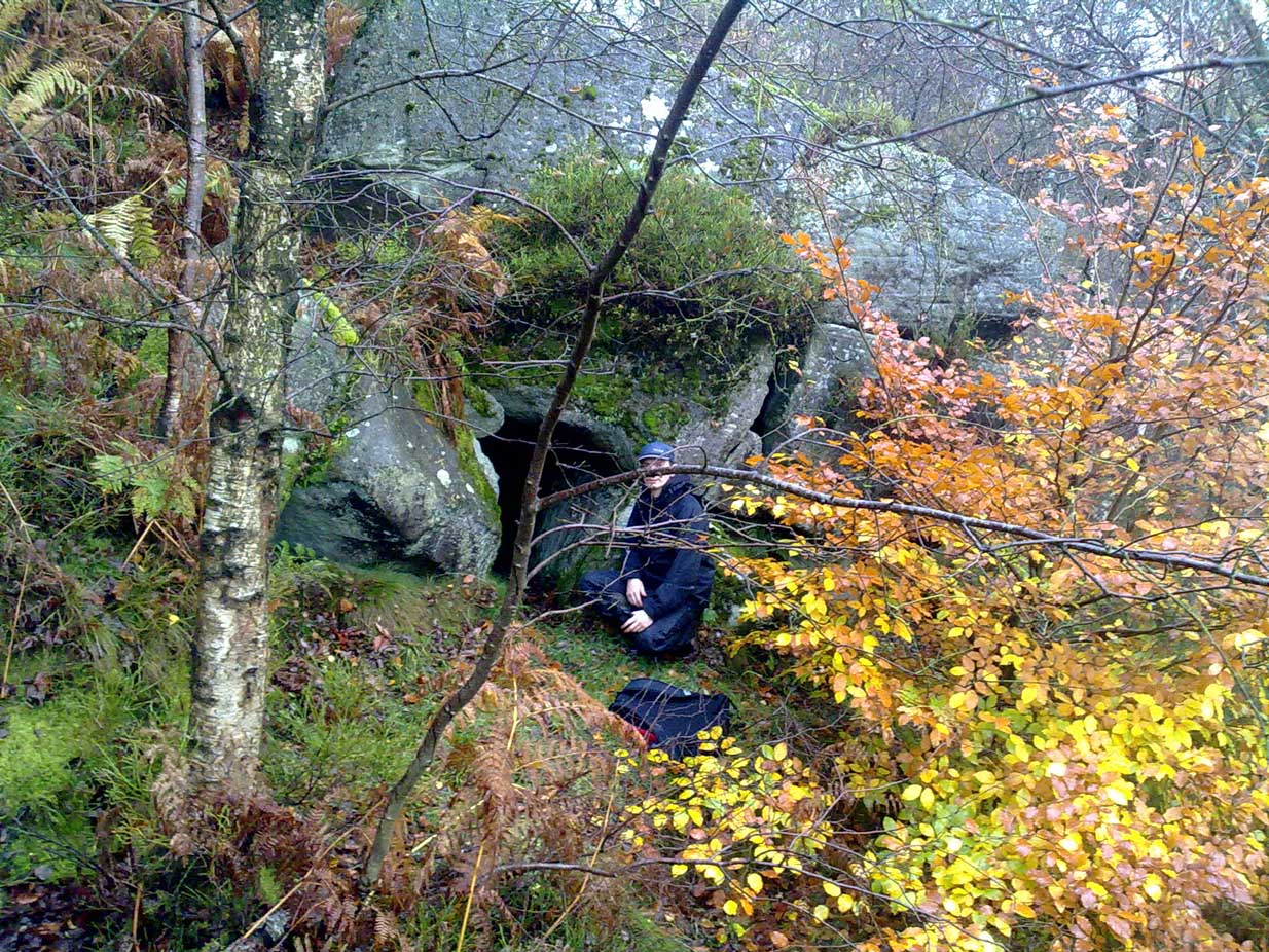
Park at Wyming Brook nature reserve car park off Redmires road and head off up the steps to the right of the notice board. Turn immediately right through the trees and you’ll soon pick up the path running along the ridge above Wyming Brook drive. Stay on the obvious path for around ½-mile passing “Big rock” to your right and the views it offers over Rivelin Valley and the dams. A short way further along the path steps down a couple of feet and turns to the right before straightening again, this is where you need to start looking down the edge to your right for a large rock that resembles a Chesterfield sofa which makes up part of the shelters roof.
Once you’ve located the site a short scramble will be needed to gain access to the entrance and this is where care is needed. It’s not difficult but has the potential to be deadly due to the steep nature of the edge so please take care and keep any kids on a very short rein.
Head down to the right of the “sofa” and jump down the 3ft drop holding onto the rather handy bracken and saplings if needed and the entrance is right there to your left.
Archaeology & History
Errr……..yeah, it’s history! — Well I’ve yet to find anyone else that actually knows about this cave, let alone it’s past! There are obviously locals who know of it’s existence but after half a dozen visits there I’ve not seen anyone except a brave old lady, 70 if-a-day, who was there looking for the supposed wartime carvings and that was on my first visit.
I have tried every possible avenue i know to reveal the caves past but as yet nothing, I’d be grateful if you could enlighten me at all.
I did e-mail John Barnatt with hope he’d have some information but alas no, though it is admittedly just outside his patch being on the Sheffield side of the Derbyshire / Sheffield border.
The shelters entrance is around 3ft high but once inside the roof quickly gains height and tops out at around 7ft so standing is easy. Beware half way along the interior by the small opening though — you’ll crack your head if your attention is drawn to the light beaming in through the side! There’s quite a bit of occupation rubbish within the cave due to someone making their home there: a sleeping bag, old tin cans, bottles, etc, is evidence enough, but the stuff’s quite old and no one resides their now.
“X” marks the spot!
At the far end of the shelter is a small chimney like opening and it’s just possible to squeeze between the fallen rocks and make your way out, it would also make an excellent outlet for smoke if you chose to have a warming fire inside.
You probably won’t notice on your way in but coming out and on the rocks by the entrance to your left are carvings dated to 1944 said to have been inscribed by German prisoners of war held in the area but I’ve yet to substantiate that.
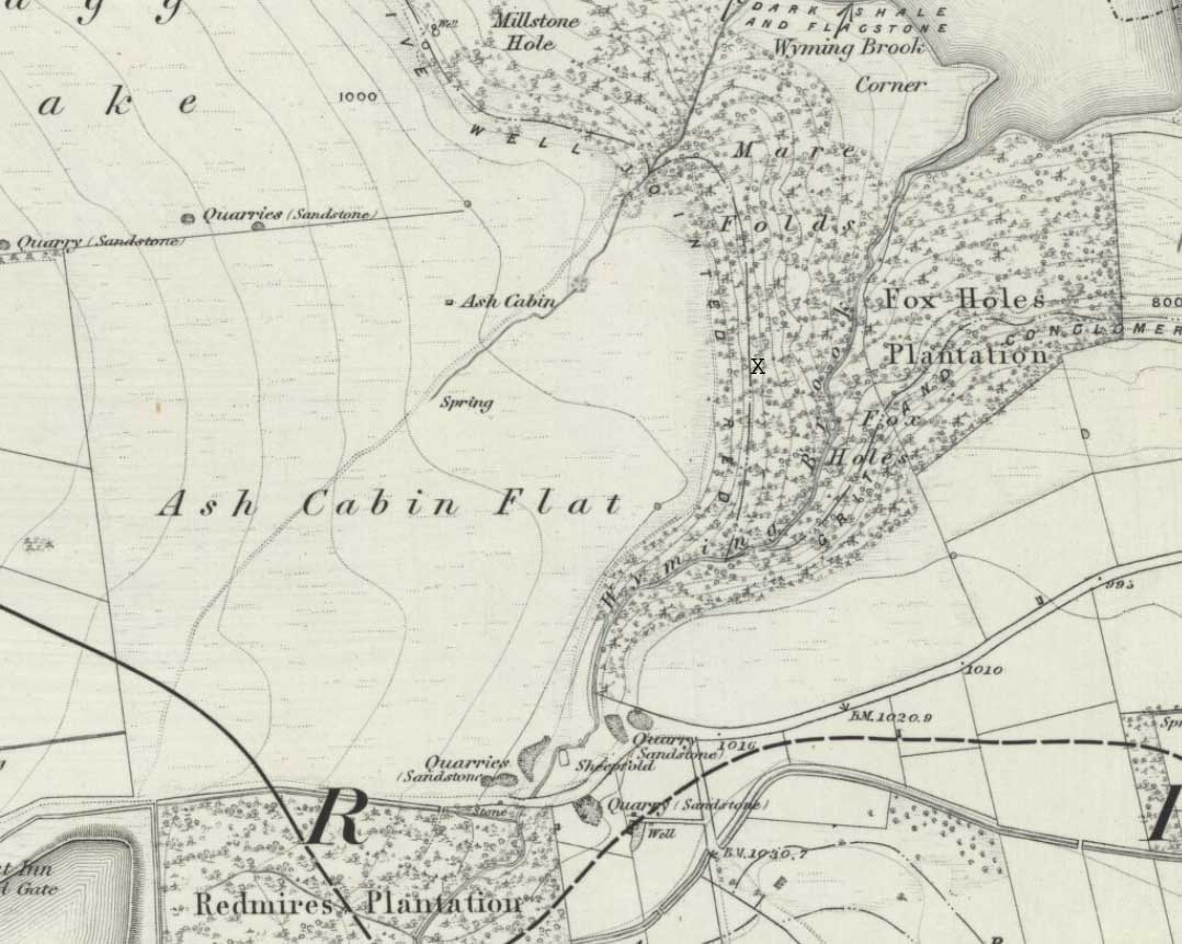
Follow Redmires road till you come to Wyming brook nature reserve and use the free parking facilities there. From the car park you need the signposted path to the right of the notice board, the first one not the one by the metal barrier; climb the rocky steps and follow the line of the dry stone wall to your left, and after around 50 metres you’ll pass through a wooden gate. You then continue following the wall as it heads downhill and the wall becomes broken. Here you should notice a path that goes through the broken wall off to your left: don’t take it but continue another 50 metres or so, then turn 90° to your right facing the moorland. The circle is around 50 metres into the heather.
Ash Cabin Flat Stone Circle – as of 26/5/09
Archaeology & History
A fairly well preserved late neolithic or early Bronze age embanked stone circle located in a sea of heather on Ash Cabin Flat on the Western outskirts of Sheffield and rediscovered in 1981 due to the moor being burnt back.
The site is oval in shape and around 9m x 7m diameter to the outer edge of the bank. The banking is well preserved and shows there was no entrance to the interior.
There are around a dozen stones within and on top of the bank but it’s uncertain whether they are circle stones or packing stones from the bank. English Heritage have recorded 5 of the stones, 2 still standing, as stones that once stood making up the circle.
If you visit any time soon (23/11/09) you’ll find the moor has been burnt back again giving an excellent view of the site, when the heather is in full flow it’s as high as the highest stones making not only finding the circle nigh on impossible to find but also defining the site very difficult.
Additional Notes:
Editor – 1.12.9. – Following a visit to this site in the company of Megadread recently, we found what appears to be a number of other cairns on the flat moorland plain around this seeming cairn-circle site. There also appeared to be distinct evidence of ancient walling. Further archaeological evaluations are required here.
References:
Burl, Aubrey, The Stone Circles of Britain, Ireland and Brittany, Yale University Press 2000.
 The location of this site has proved troublesome. Even when Rob Wilson (1991) did his local survey of holy wells he was unable to locate it—but it looks as if it shouldn’t be too troublesome to find, as the area in which it flowed is still very much a mix of open countryside and maintained landscapes. Described briefly as the “Wishing Well near Whiteley Wood” in Sidney Addy’s (1893) fine work, he makes a rather hopeful attempt to derive the word ‘wishing’ from German mythology, where “one of the names of the god Wuotan or Odin was Wunsch or Wish.” But – well – you just never know…..