Standing Stone (destroyed): OS Grid Reference – TM 052 809
Folklore
This slab of sandstone apparently used to stand upright in one of the fields of Oxfootstone Farm and on its surface is supposed to be the burnt impression of a cow’s hoof-print. Legend tells that there was a fairy cow which would come into the area when times of hardship occurred. During such periods she would freely give her milk to the people, but when the drought was over she stamped down on the stone upon which she stood, burning the imprint of her hoof onto it and magically vanished back from whence she came. A variation of the tale tells of a normal cow whose milk normally supplied the local villagers. But one night a drunken man (in another tale it is a witch) milked the cow dry through a sieve, until only blood came from her udders. At this point, the cow cried out in pain and kicked the stone so hard that she left the mark of her hoof-print on it.
Another tale tells that an ox got a large thorn stuck in its foot and rampaged through the local village, eventually stamping its hoof onto the stone so hard that it left the imprint of its foot here.
Now this might sound presumptious of me — but this tale has all the hallmarks of it being an old folk-remnant telling the origin of some cup-and-ring marked stone. We find a number of cup-and-rings with creation tales similar to this. Are there any local archaeologists or enthusiasts in Norfolk who might be able to locate any remains of this possible carved stone?
References:
Burgess, Michael W., The Standing Stones of Norfolk and Suffolk, ESNA 1: Lowestoft 1978.
Dutt, W.A., The Ancient Mark-Stones of East Anglia, Flood & Sons: Lowestoft, 1926.
A bittova wander with not much to see, if truth be had. Best way here’s from the top Oakworth Road heading to the Lancashire border, right on the moor-edge. Go along the Hare Hill Edge road for a coupla miles till you hit the Pennine Way. Walk along it up onto the moor, following the dead straight walling for several hundred yards. Where the walling stops, all of a sudden, stop! (there’s a wooden post here) Now walk left (west) across the heath for less than 100 yards. You’ll find it…
Archaeology & History
Old Bess Stone, with Crow Hill on the distant skyline
I’ve found nothing of this site in archaeology records – but that’s likely down to me not looking hard enough! I’m not even sure that it’s prehistoric – but as there’s nowt written about it, and there are other sites which relate to this old stone, it’s certainly worthy of mention.
The stone lays in the grasses, some four-feet long, with a more recent 18th-19th century boundary stone laid a few feet away. It seems most likely that Old Bess had stood here much longer though. Old Bess seems to be the first in a row of at least 6 seemingly unrecognized boundary stones running northwest in a straight line up to the Wolf Stones, about half-a-mile from here. Neither the early, nor modern OS-maps show any of these stones, several of which are accompanied by earlier, more worn stones – two of which have the letters ‘C.C.’ or ‘G.C.’ carved on them.
Old Bess ‘hut circle’ (it’s there – honest!)
About 10 yards north of Old Bess are the remains of a very noticeable oval-shaped ‘hut circle’ – or something closely resembling such remains. About five yards across at the most, with stone walling making up the edge of the ring beneath the moorland grasses, an excavation here wouldn’t go amiss! Although it’s hard to see in this photo (it’s the roughly circular rise in the middle), when you’re on the moor it’s obvious. It looks and feels as if the remains were something from medieval times, or perhaps even later – but it’d be good to know for sure! The remains of an old delph 100 yards south may account for more of Old Bess and its accompanying hut circle than owt prehistoric.
From Old Bess, walk in a straight line towards the large rock outcrop of the Wolf Stones, northwest of here. After a short distance you’ll come across another large stone, cut and shaped in bygone centuries (not prehistoric though) laying in the boggy tussock grass and looking similar to Old Bess. Another 100 yards on from here, along the same straight line towards the Wolf Stones, you’ll find another cut stone of similar dimensions; and from here you’ll see another stone about the same distance again ahead of you. These would appear to be the lost medieval boundary stones which led to a boundary dispute between the counties of Yorkshire and Lancashire a few centuries ago. For those medieval historians amongst you, check ’em out: it would appear that these are the lost stones (pushed over, obviously) which led to the said dispute. How on earth no-one’s found ’em previously beggars belief!
Folklore
A little-known site with a spirit ancestor giving rise to its name. Surrounding it are tales of little people, for just above it is where the faerie lived at the Fairy Fold Dike. While a couple of hundred yards west lived an old hob (another faerie creature) who used to drink from an old well named after him, the Hob Ing Spring. Victorian lore tells of druidic folklore further up the moor by the old Wolf Stones, which is linked to Old Bess by virtue of the line of old boundary stones running from here.
Dead easy. Follow the Grassington-Pateley Bridge road (B6265) east and about 2 miles past Hebden village, the craggy hill rises to the left-hand side of the road, as you can see in the photo below. Simple!
Archaeology & History
Nursery Knott hill
When fellow rock-art freaks Graeme Chappell, Richard Stroud and I were exploring the cup-and-ring stones in the area just south of here a few years back, this hill kept calling out with some repeated awe. “There’s summat about that place,” were the remarks we kept saying – but we could never put our finger on it. (still haven’t if truth be had!). Between here and the awesome Simon’s Seat to the south, a whole panoply of neolithic and Bronze Age remains scatter the land — and if ritual landscape has any validity, this hill is undoubtedly enmeshed in the mythic framework of such a paradigm. But without any folklore I didn’t feel right to include it here…
At the northern or rear-end of this great outcrop (SE 082 640) is a scattering of many boulders, one of which in particular at Knot Head was explored by a Mr Gill in 1955 and found to have a number of Mesolithic worked flints all round it. Seems as if folk have been up to things round here for even longer than we first thought. Microlith or flint-hunters would probably do well on the moors up here!
Folklore
It’s the old pen of our Yorkshire topographer Edmund Bogg which brings the lost folktale of this place back to life – and it’s typical of aboriginal creation myths from elsewhere in the world. In his Higher Wharfeland he had this to say of old ‘Nursa Knott’, as it was locally known:
“The old legend is that the devil, for some reason anxious to fill up Dibb Gill,* was carrying these ponderous crags in his apron when, stumbling over Nursa Knott, the strings broke and the crags fell. Legend also says, should the crags be removed they will be carried by some invisible power back to their original position.”
He then reminds us of links with old Wade, plus the settlement of old Grim, a short distance to the north.
Across the road down the track running south to Skyreholme, Jessica Lofthouse ( 1976) told the tale of a ghostly horseman, seen by her great-grandfather no less! Suggesting he may have been ‘market merry’ (i.e., pissed!), she told how he “struck out at a spectral white horse at the Skyreholme three-land ends near Appletreewick – and his stick passed through it!”
References:
Bogg, E., Higher Wharfeland: The Dale of Romance, James Miles: Leeds 1904.
Lofthouse, Jessica, North Country Folklore, Hale: London 1976.
Walker, D., ‘A Site at Stump Cross, near Grassington, Yorkshire, and the Age of the Pennine Microlithic Industry,’ in Proceedings of the Prehistoric Society, 1956.
* Dibb Gill is nearly a mile due west of here – and Dibble’s Bridge which crosses the beck was also known as the Devil’s Bridge, with a few typical creation myths of its own attached.
This is the highest point of the moors, 1320 feet up. There’s various ways of getting there: I’d favour the wander up to Twelve Apostles then taking the 15 minute walk west to the triangulation point which marks the spot. If you reach the large rocky outcrop of the Thimble Stones, you’ve gone too far; although you can walk past the Thimbles, if you’ve started your walk from the two radio masts atop of the moor where the old Roman road hits the dirt-track. Either way, unless you’re damn stupid, this is an easy spot to find!
Archaeology & History
Although today there’s little to be seen, when Collyer & Turner (1885) described the place it was 175 yards in circumference! Bloody huge! When Harry Speight got here in 1900, it had shrunk slightly to 150 yards. Now however, almost all the stones have been robbed. I first came here when I was just 11 years old and remember it was a decent size even then – at least as large as the Little Skirtful and Great Skirtful of Stones more than a mile to the east. Today however, unless you knew it was once a giant cairn, you wouldn’t give it a second look.
It’s quite appalling what’s happened to this site thanks to the sheer ignorance and neglect of the local archaeologist in tandem with his paymasters at Bradford Council: 90% of the site has been utterly vandalised and destroyed as a result of these incompetent idiots in the last 20 years. Nowadays, all you can make out here is the raised earth for about 10 yards surrounding the trig-point. It seems that most of the stones that comprised this giant cairn have been taken for use in walling, and to prop up the stupid paved footpaths which the local Council and its affiliated halfwits are slowly building o’er these hills.* Morons!
Aar Dave on top o’ t’ moors
I’m not quite sure why it was called Nixon’s Station. It was J. Atkinson Busfield (1875) who mentioned this name, quite casually in his fine local history work, as if local folk had known it as such for sometime. There was also an inference of it being the resting place of some old general, but I’ve found nor heard anything more along such lines — though worra superb place for your spirit to roam free…..
If anyone has any old photos of this once giant prehistoric site, it would be good to see it in its old glory once again. When I wandered up here as a kid, I never carried things like a camera about (being a Luddite by nature!).
References:
Busfield, J.A., Fragments Relating to the History of Bingley Parish, Bradford 1875.
Collyer, R. & Turner, J.H., Ilkley, Ancient & Modern, Otley 1885.
* Anyone know exactly which idiots are responsible for the stone footpaths being laid over the moors here? They’re damn stupid and cause even more erosion and damage to the environment and prehistoric heritage up here, as anyone with an ounce of common sense can see. Can someone please get them stopped!?
There are several ways to get here, but I took the one from the road (B6265) walking up the track into Crookrise Woods. Unless you’ve got a decent OS-map with it marked on, this might take some finding to some folk as it’s tucked away on the northern edge of Crookrise Woods (which one Southerner bloke told us was private – though he was ‘allowed’ there!). It’s right on the rounded knoll at the top of the woods, beneath the prominent slopes which lead to the moor.
Archaeology & History
Our old mate and Yorkshire historian Arthur Raistrick seems to have been the first to describe this place in the Yorkshire Archaeological Register of 1964 – though the holy wells writer Edna Whelan told me she knew about the place many years back. Today hidden in woodland and mostly overgrown, Raistrick’s brief description of the place said:
“A small stone circle of six stones set symmetrically within a diameter of 26 feet. The stones vary in size from 21 to 58 inches. Surveyed 1963.”
The site has been badly affected by the erosion of time, forestry and god-knows what else. Scattered around are numerous small stones giving the impression that it may once have been a cairn-circle, more than a stone circle. Four of the six stones mentioned by Raistrick (1965) are visible, but none are impressive – and unless you’d read about the place first or found it in Mr Burl’s Stones Circles of Britain… (2000), you wouldn’t really give it the time of day.
Although sadly disappointing in its present status – completely surrounded by trees, with no view at all – it seems probable that it would have had some geomantic relationship with the hillfort-looking site of Rough Haw immediately west, and very probably the adjacent ritual site of Sharp Haw. It seems that the equinox sun would set between Rough Haw and the other small rounded hill above.
References:
Burl, Aubrey, The Stone Circles of Britain, Ireland and Brittany, Yale University Press 2000.
Various ways to get here. I s’ppose the easiest is from Dacre village. If you go just past Sunny House, take the footpath on your right & walk along it, roughly straight across a number of fields, until you hit the footpath known as the Nidderdale Way. The field you’re now in should be scattered with numerous rocks all over the place (if it aint, you’re in the wrong place), reaching down towards the trees. Walk straight towards the trees for another 100 yards and the carving is somewhere hereabouts under your nose! You’re very close! If, however, you decide to walk up the Nidderdale Way from Dacre Banks, the field you need is the one immediately to your right just before you reach the Monk Ing Road trackway. The Tadpole Stone (or Eastwoods Rough II carving) is in the same field, close to the Nidderdale Way path — check that out aswell!
Archaeology & History
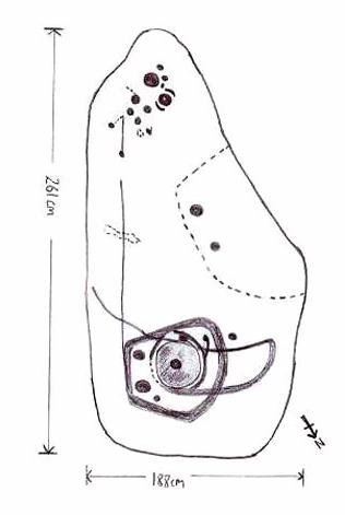
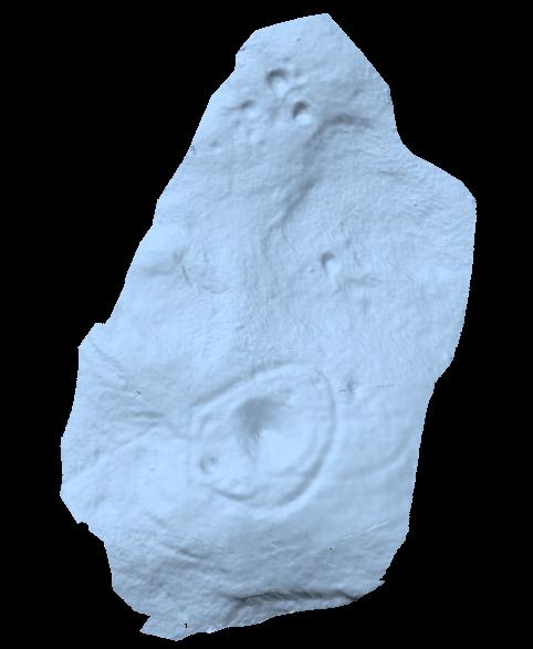
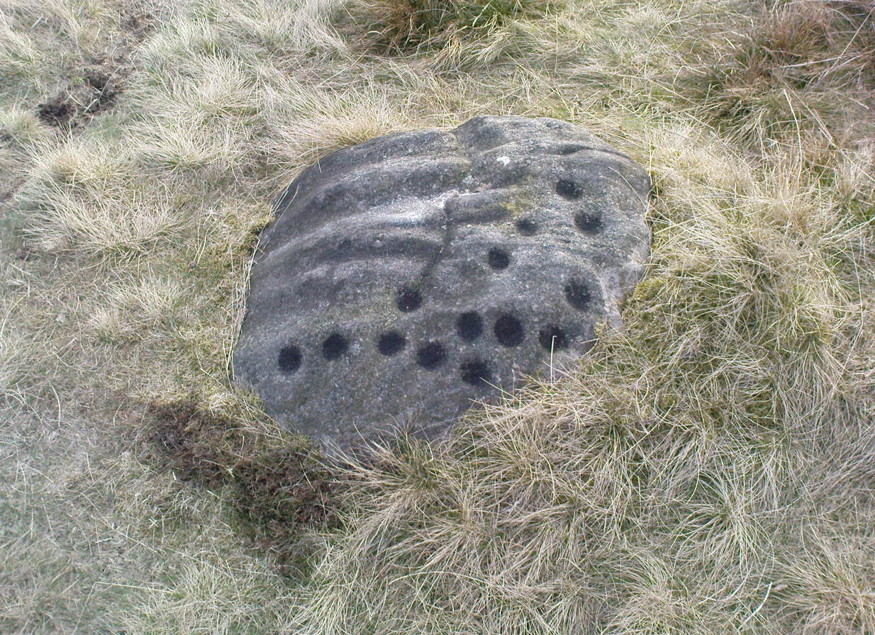
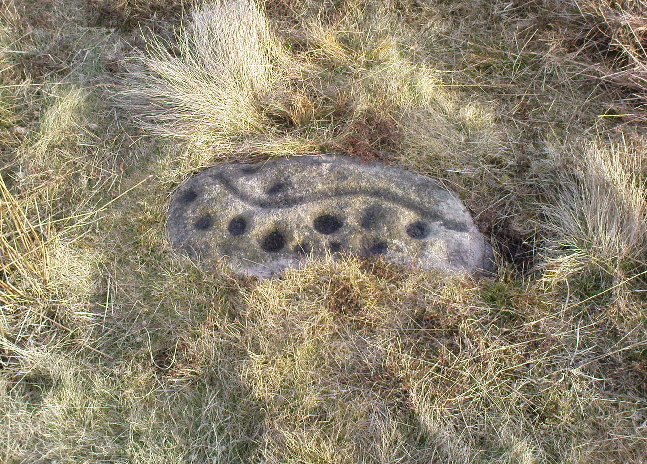
This is a large carving I found in April, 2006, in the company of rock-art student Richard Stroud (who sent us the pictures). Twas in the midst of a fine day wandering about checking some of the ‘known’ sites in the area, when we happened across two or three previously unknown sites — and as the day wore on, just before we were gonna head for home, this little beauty poked the edge of its head out of the turf! It had the pair of us in near rapture, with numerous “Wow’s” and excitable expletives coming from our mouths! We’re easily pleased us rock-art doods — but then it is a beauty when you first see it.
We came here several times in the weeks following its initial discovery, and it seemed that on each visit, we found an additional aspect to the carving. It seemed to keep changing each time we came here — hence the name ‘Morphing Stone’!
The prime feature in the carving is the very large oval-shaped ‘ring’ with huge carved bowl in the middle and several outlying cups-markings around it. Although it’s not plain to see in the photos, there’s a large tongue-shaped protuberance jutting out from one side of the main ringed feature. You can also see a small cluster of cup-marks on the top-right of the rock: from here — though it isn’t easy to see in the photo — a long straight line links up with the edge of the major central ring. Other lines run off on the top of the main feature and there are several other cup-markings on different parts of the stone. It’s obviously best to see the carving “in the flesh”, so to speak, to get a good impression of what it actually looks like. And, to those of you who might wanna venture up here, there are several others nearby.
A year or two after rediscovering the carving, rock art student Keith Boughey (2007) described the stone, saying:
“Measuring 2.61m from N-S and 1.88m from W-E at its greatest extent, the carved surface carries quite a complex design… At its N end is a large cup/basin with an approximate diameter of 25-30cm, surrounded by a ring that may or may not be complete: 2 cups have been incorporated into the ring on its N and W side. W of this ring a groove leads off S to a further possible cup. On the E side of the large central cup are 3 further cups of varying size. These motifs are all enclosed within a wide groove, which forms almost a dome pattern. Out of the ring, a further groove runs NW out of the design, bisecting the enclosing groove, curving round to form a handle shape before running back in towards the large central cup. The groove shows signs of continuing E towards the edge of the stone. Just outside the W edge of the enclosing dome is one well-defined cup. S of this, in a slight depression, are 2 further cups of differing size. A straight groove appears to run SW out of the enclosing dome shape on its E side towards further motifs on the stone’s S side. The groove may run into an area of cup marks, but there appears to be a break before it continues. When exposed, the carvings looked quite fresh and sharp, suggesting that they had remained covered for some considerable time – possible since antiquity or at least from a time in the prehistoric past when cup-and-ring-markings had begun to lose their significance and were no longer required to be visible in the landscape.”
To those of you who like the new computer images of cup-and-rings, the three below are samples from a number of such images done after the stone had been discovered. Intriguingly, the long line running between the cluster of cups to the large cup-and-ring doesn’t show up too well; but the barely perceptible line running out, zigzag-fashion, from the large central cup-and-ring, shows up much clearer than when looking with the naked eye.
Although destroyed, to those who wanna check the locale, from Bingley take the Eldwick road and keep going all the way up to Dick Hudson’s public house, right on the edge of the moor. From here, go left (east) on the road for less than a mile until you reach the reservoir/lake on your right. Take the dirt-track down here for 100 yards and stop! It was somewhere here!
Archaeology & History
I first went looking for this site when I was a kid (about 13 years old), but soon discovered that it had been destroyed. The first person to write about it was lucky enough to see it when it was still there. Harry Speight came here around 1890 and described,
“descending (from Pennythorn Hill) towards Faweather we enter (by permission) a field at Birch Close Farm, and here we find evidence of an extensive stone circle, some of the large unhewn stones having been built into an adjoining wall. In the next field is a rock sculpture with…cup and ring marks.”
This cup-marked stone still exists at Faweather, though has now been enclosed by a garden. The occupiers are quite friendly and are willing to let you look at the stone if you ask kindly. Anyway…..by the time Butler Wood wrote about the place in 1905, he was telling that “the finest stone circle in the Rombald’s Moor area was demolished some years ago.”
The local historian W.E. Preston, marking an old map of the region with an “X,” wrote:
“NOTE! The circle was destroyed here during construction of the Baildon Waterworks, 1892. Diameter 25 yards. It consisted of a wall of rubble with upright stones at frequent intervals.”
Subsequent descriptions of the site in 1905, 1929 and 1946, cited Weecher to be 27 yards across. My last search for any remains of this circle was in 1990 when I explored every wall in the region, hoping to find one or two of the old uprights, but they had all gone. Sadly, there appear to be no drawings or illustrations of the site either…
Folklore
This stone circle was one of at least four circles that played a part in one of the most impressive leys I have seen! Starting at the circle in Hirst Woods, Saltaire, the alignment goes north, crossing the Brackenhall circle, a few other Bronze Age sites, across the site of Weecher, and finally terminates at the Great Skirtful giant tomb a short distance north of here.
References:
Bennett, Paul, The Old Stones of Elmet, Capall Bann: Milverton 2001.
Cowling, E.T., Rombald’s Way, William Walker: Otley 1946.
Gray, Johnnie, Through Airedale from Goole to Malham, Walker & Laycock: Leeds 1891.
Raistrick, Arthur, ‘The Bronze Age in West Yorkshire,’ in YAJ 1929.
Wood, Butler, ‘Prehistoric Antiquities of the Bradford District,’ in Bradford Antiquary, 2, 1905.
About 10 yards north of the old boundary stone on the Middle Ridge heading to the western end of Dryas Dike and about 10-15 yards east of the Middleton 453 carving, is this small rounded rock with between 12 and 15 cup-markings on its north and north-eastern sides. Several curious deep ridges run down across the rock which some ascribe as being man-made – but to me they’re Nature’s fine handiwork, although I may be wrong…
References:
Boughey, Keith & Vickerman, E.A., Prehistoric Rock Art of the West Riding, WYAS 2003.
Named boringly after the catalogue number given it in Boughey & Vickerman’s (2003) survey, this is another of the many small cup-marked stones clustered at the western end of the ridge between Delves Beck and Dryas Dike, below the moorland slope up to the Old Pike and Beamsley Beacon. It’s one of the more impressive of the carvings in this locale, albeit when it’s highlighted, as in the photos shown here (apparently done by one of the photographers in the Ilkley rock art group, I was told). It’s perhaps better seen when the sun is low and the stone’s been wet, which shows the shallow undulations of the cup-marks and wavy line that seems to split the main group of twelve cup-marks at the top northern side of the stone, from the two on its south side. There seems to be another wavy line carved above the main cluster, but this is difficult to make out.
References:
Boughey, Keith & Vickerman, E.A., Prehistoric Rock Art of the West Riding, WYAS 2003.
From the old T-junction in the hamlet of Langbar (where some doods have stuck up one of those ‘Private Road’ signs, typical of those Southern-types who bring their weird private land notions up here), go along the ‘private road’, keeping to the left until the road runs out. Then follow the small footpath above the house onto the moor, following the lines of walling along, crossing boggy streams, up the small hill and, once over the top and dropping down, keep your eyes peeled for the large boulder to the left of footpath, and a small scattered cairn on your right. It just a few yards past the cairn material!
Archaeology & History
Just 20-30 yards up the slope on the north side of Dryas Dike stream, to the left of the footpath, is a small, rounded flat stone with perhaps as many as eight cup-markings on it. Six seems more believable — though some of ’em on here (if not all) don’t look to have the air of authenticity that some of the other carvings hereabouts possess. One of the cups has a small ‘tail’ protruding from it. It’s a rather cute little thing! A small, unexcavated cairn lies in ruin about 10 yards east of the crude carving.
…and from another angle
On the other side of the footpath from here is that “large boulder” I mentioned above, which is reported by Boughey & Vickerman (2003) to have “one clear cup” marking etched upon it. They also report that archaeologists from “English Heritage report two cups and a possible short groove” on this rock. However none of the carvings reported here by either authority are man-made. All marks on the rock are completely natural and it needs omitting from any future archaeological survey.
References:
Boughey, Keith & Vickerman, E.A., Prehistoric Rock Art of the West Riding, WYAS 2003.