Queen’s Cairn, Farr, Strathnaver, Sutherland

Chambered Cairn:  OS Grid Reference – NC 7247 5687

Also Known as:

  1. Canmore ID 6212
  2. Skelpick

Getting Here

The great Queen's Cairn
The great Queen’s Cairn

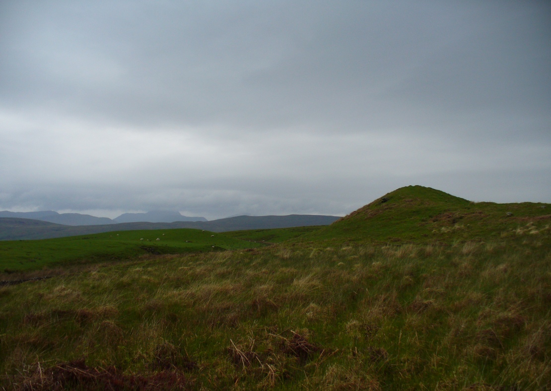
From Bettyhill village, take the road east towards Tongue and Durness.  A half-mile out of the village, at the bottom of the hill, just before you cross the small metal bridge across the River Naver, a very minor road, left, takes you to Skelpick. Go down here and follow the directions to reach the giant long cairn of Skelpick Long.  Once there, walk east up the moorland hill (there are no footpaths) for about 150 yards.  Once on top of the rise, the moorland levels out a little and there, before you, amidst the small overgrown undulations of many old cairns, a giant one rises up to greet you about 100 yards away.  Y’ can’t really miss it!

Archaeology & History

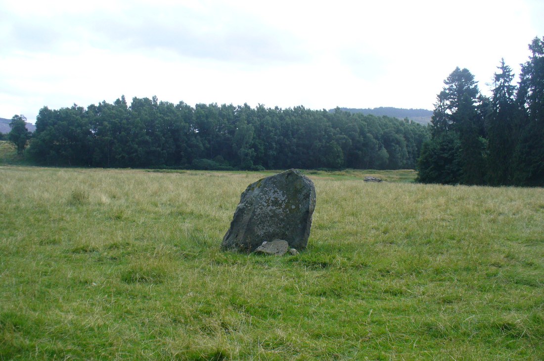
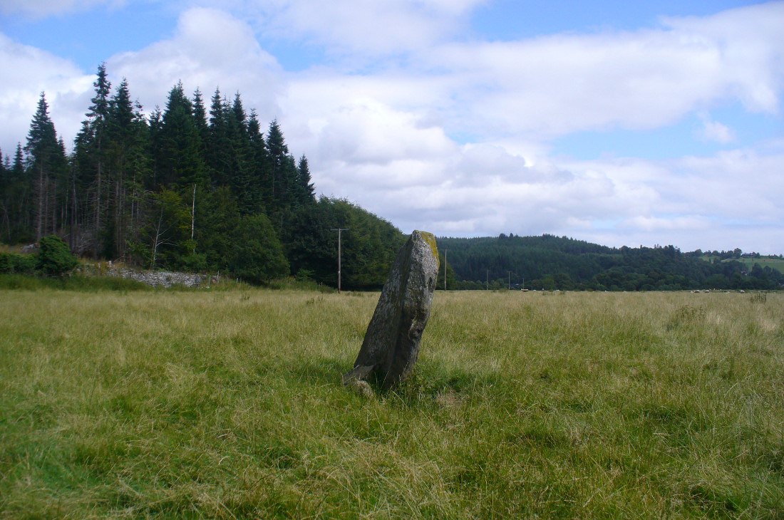
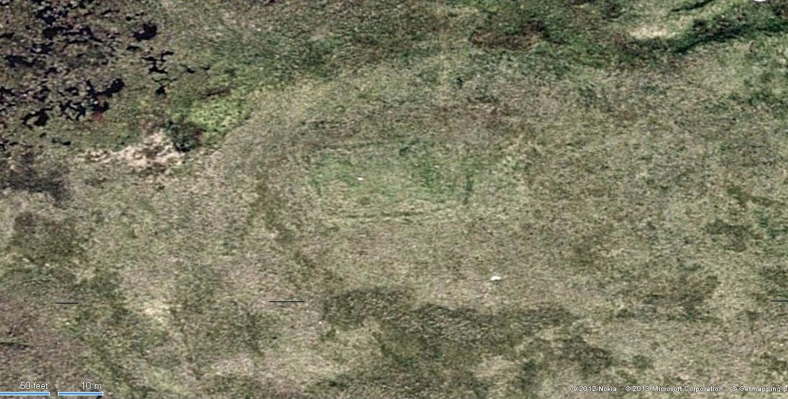
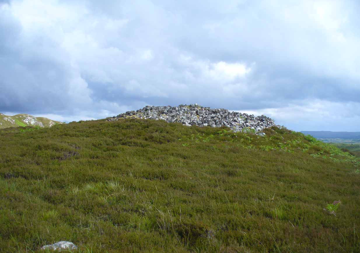
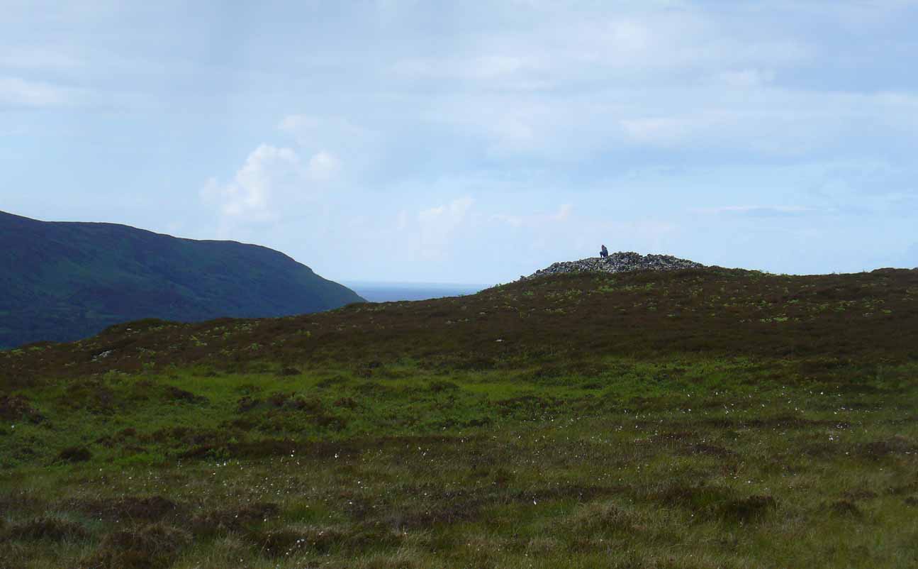
Neolithic in nature, this giant circular cairn, standing on the ridge above the hugely impressive chambered long cairn of Long Skelpick, isn’t quite as grandiose as its neighbour below, but it’s still an impressive feature in this beautiful moorland landscape.  Comprised of tens of thousands of small stones raised to a height of 10 feet above the moorland peat, several ‘pits’ have been dug into the top of this undoubted tomb of regal nature; but whether it was originally the burial-place of a single person, to which were later added members of the same family, is simply unknown.

queens-cairn35
Moss-covered capstone
Depression atop of the cairn
Depression atop of cairn

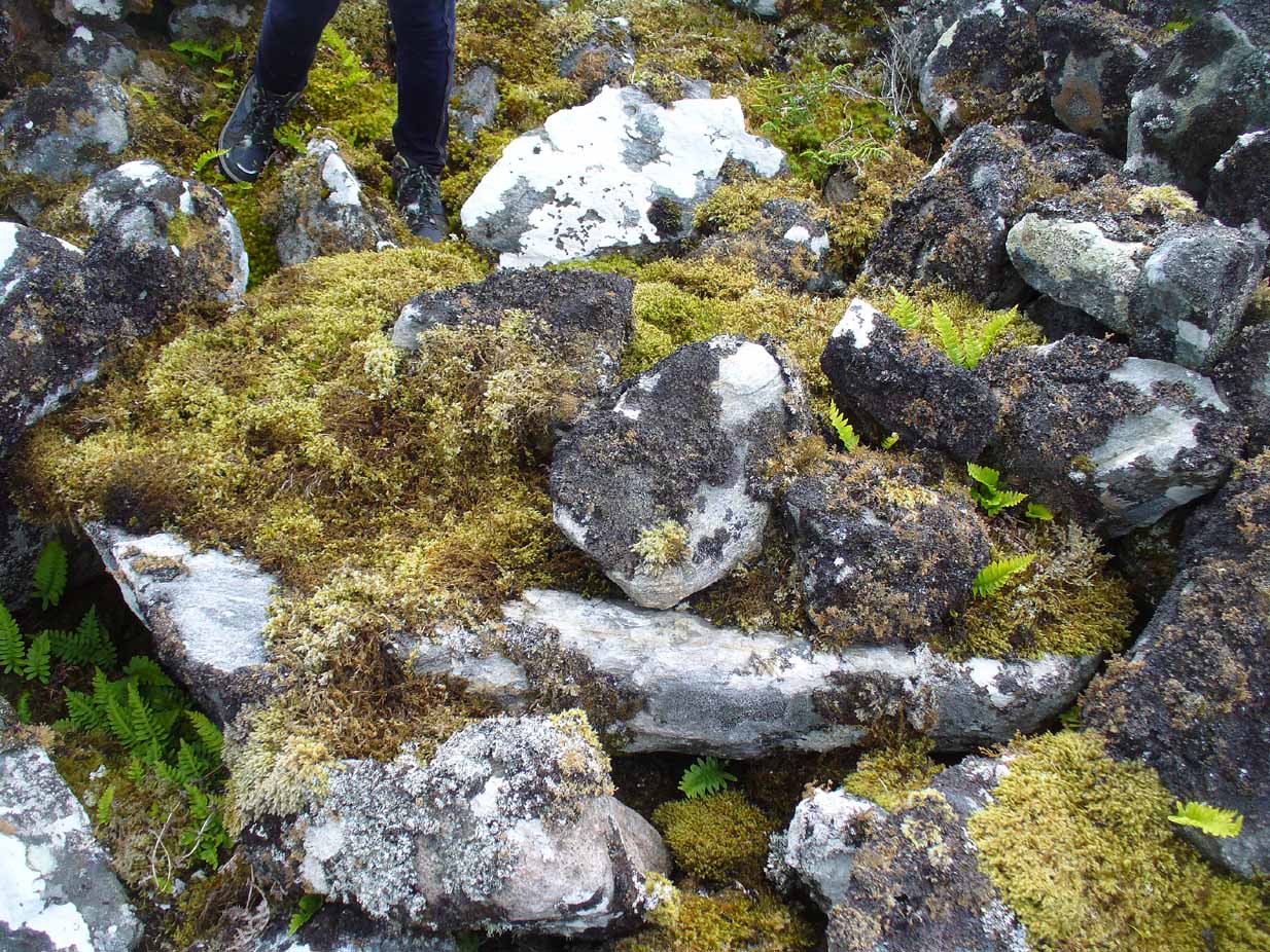
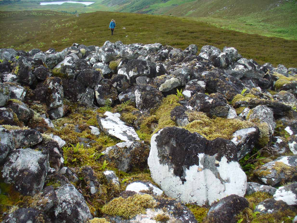
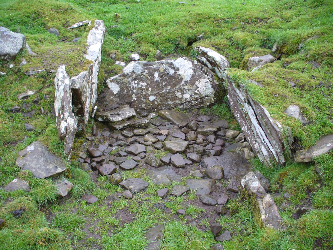
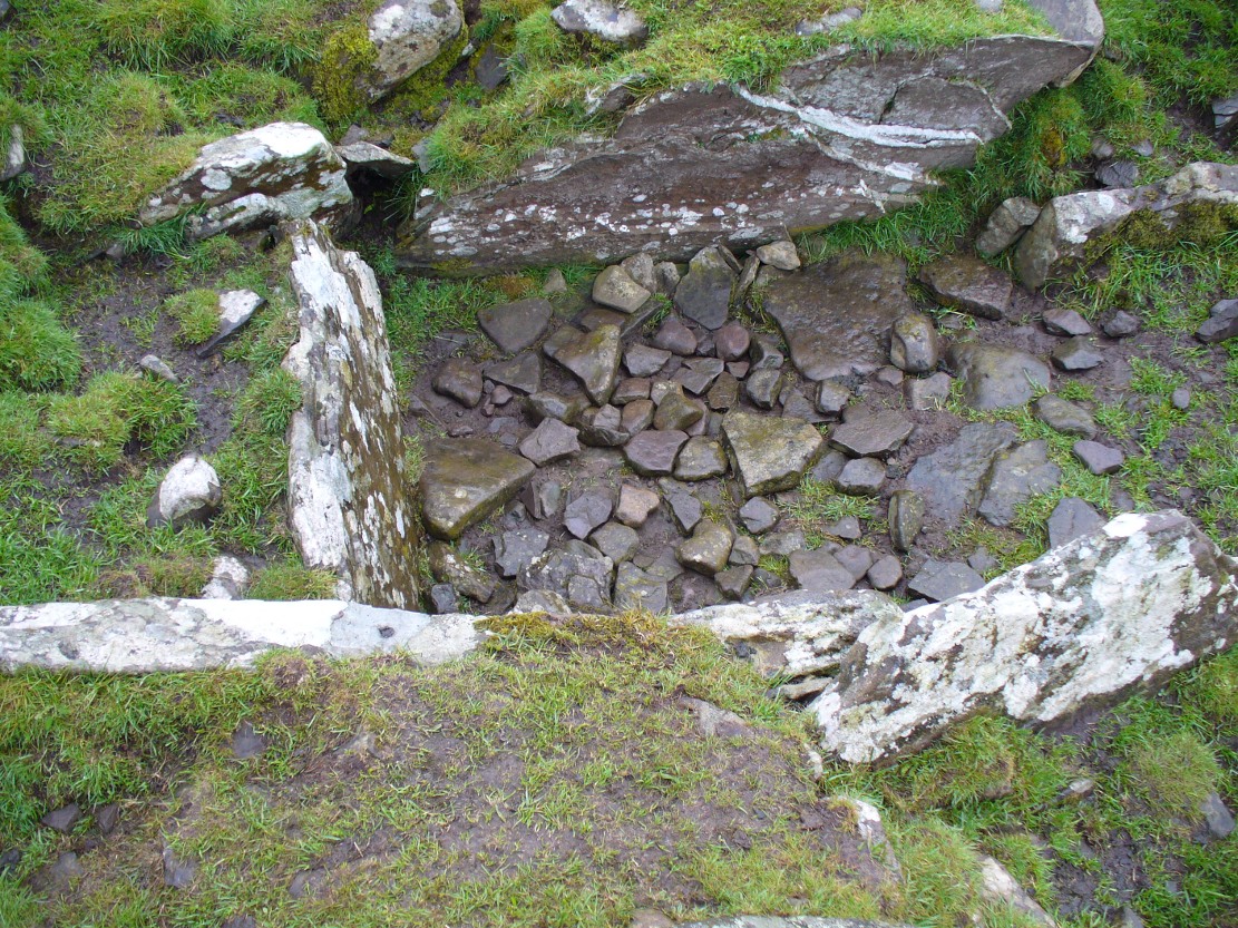
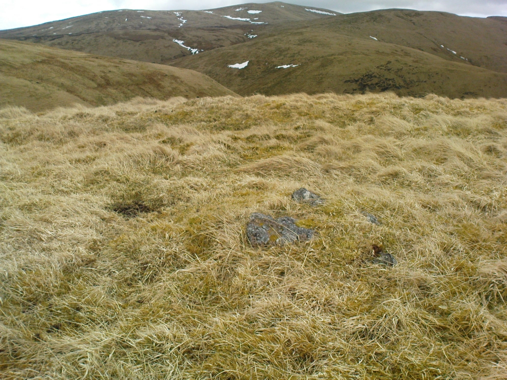
On the top of the cairn, at least one of the so-called ‘pits’ that drop into the centre is covered by a large heavy tombstone with a small upright monolith at its side.  Although the late great Miss Henshall (2005) thought no ‘chamber’ was here, it is quite possible that a chamber might be found beneath this large moss-covered flat rock (see photo).  When we visited here, it looked as if there was a hollow beneath it, but only an excavation would tell us for sure.

Mass of cairns on 1878 map
Mass of sites on 1878 map

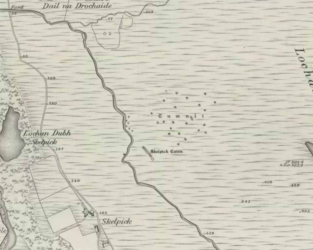
Highlighted on the earliest Ordnance Survey map, it was shown to be just one cairn amidst the mass of other smaller surrounding tombs—most of which were probably built for people from the same tribal group.  None of these small cairns have been excavated, but they were probably built after the construction of the major Queen’s Cairn.

The Royal Commission lads visited the site in 1909, but said very little of the place (probably over-awed by Long Skelpick, Coillie na Borgie and other nearby giants!), merely that this large circular cairn has

“a diameter of about 54′.  It is about 8′ high, and though the stones have been pulled about here and there on the top, it does not appear to have been excavated.”

Queen's Cairn, looking north
Queen’s Cairn, looking N

And so it remains to this day—although the cairn is slightly larger than the dimensions given by the Commission boys.  Beneath the encroaching heather, the cairn is closer to 67 feet (10.23m) across, with a circumference of 210 feet (64.25m).

Line of ancient walling nearby
Line of ancient wall nearby

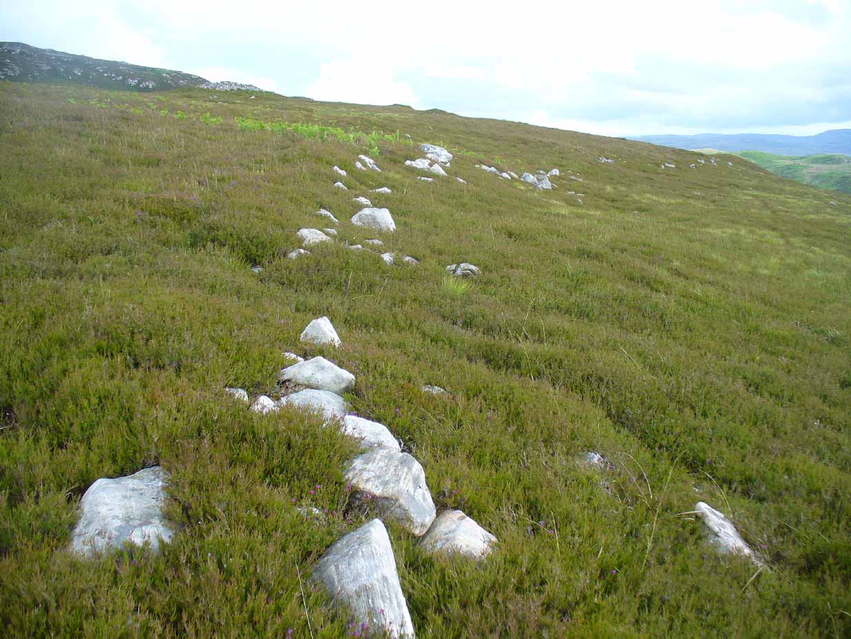
The monument sits on a plateau immediately above the giant Long Skelpick cairn—although neither can be seen from each other.  But if you walk only a short distance from the Queen’s Cairn towards the long cairn below, a very notable and extensive line of ancient walling runs along the edge of the geological ridge separating the two tombs, as if deliberately keeping them apart.  Other lines of ancient walling run closer to the cairn, seeming to indicate that a settlement of some form was also apparent on this ridge, in close connection with the group of smaller burial cairns.

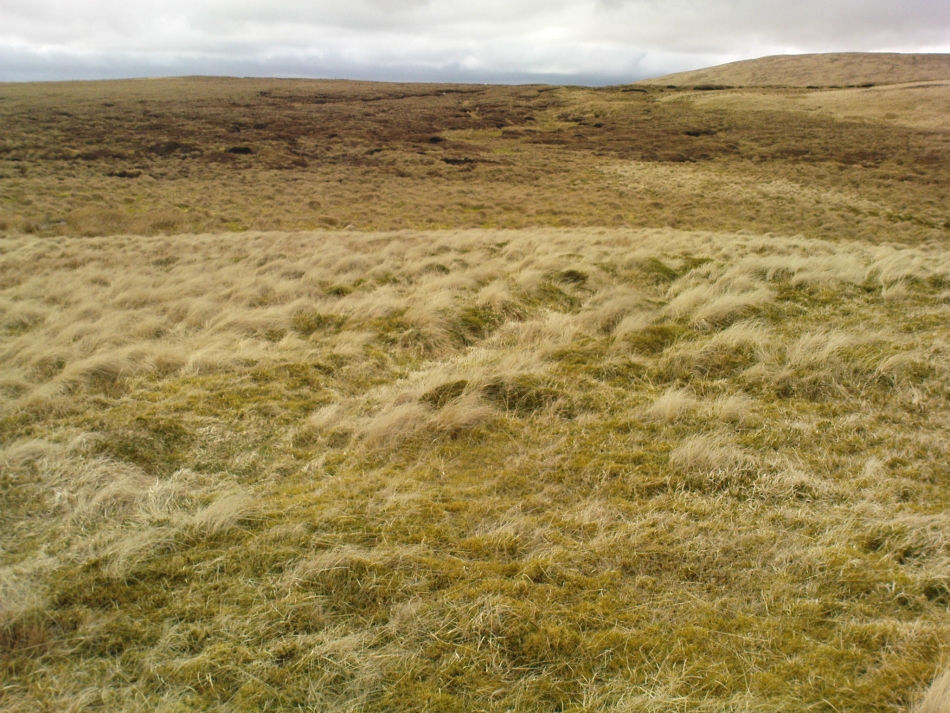
It’s a gorgeous arena with many prehistoric sites and puzzles to behold, and plenty of unrecorded ones nestling quietly in the heather.  It’s bloody superb to be honest!

References:

  1. Gourlay, Robert, Sutherland: An Archaeological Guide, Birlinn: Edinburgh 1996.
  2. Henshall, Audrey S. & Ritchie, J.N.G., The Chambered Cairns of Sutherland, Edinburgh University Press 2005.
  3. Royal Commission Ancient & Historical Monuments, Scotland, Inventory of Monuments and Constructions in the County of Sutherland, HMSO: Edinburgh 1911.
  4. Stuart, John, “Report to the Committe of the Society of Antiquaries of Scotland, Appointed to Arrange for the Application of a Fund left by the Late Mr A. Henry Rhind, for Excavating Early Remains,” in Proceedings of the Society of Antiquaries, Scotland, volume 7, 1868.

Acknowledgements:  Big thanks to the awesome Aisha Domleo & her frobbling Lara for our meandering day out to this olde place… Gorgeous! x

© Paul Bennett, The Northern Antiquarian 

Lighthouse Well, Dunnet Head, Caithness

Healing Well:  OS Grid Reference – ND 20422 75807

Getting Here

Lighthouse Well, Dunnet Head
Lighthouse Well, Dunnet

Take the B855 road northwards out of Dunnet village, through Brough and, nearly four miles on, you’ll see the waters of the Long Loch right by the roadside.  Roughly 300 yards along the side of the loch, keep your eyes peeled to left-hand side of the road, where you’ll see a white stone surround just below the roadside just a couple of yards away.  Right by its its side is a small stone with a plaque highlighting its position.  You can’t really miss it.

Archaeology & History

Stone & plaque by its side

Marked on the earliest OS-map of the region in 1875 (simply as “Well”), this is the most northerly example of a healing well in mainland Scotland, being a good mile further north than John o’ Groats!  Consisting of a standard stone surround, the well has two stone troughs: one inside the surround, and another outside, where the water runs, before being directed back to Earth.

Secondary stone trough
Second stone trough

Although the waters here have long since quenched the thirst of crazy travellers, the well was the main water supply for the men who lived and manned the famous Dunnet Head lighthouse in earlier years, who would carry the water from here more than half-a-mile up to their remote abode, overlooking the great cliffs and out towards megalithic Orkney.  Its healing properties have, sadly, long since been forgotten.  When we visited the site, the waters did not look to be in a healthy state to drink.

© Paul Bennett, The Northern Antiquarian


St. Mungo’s Well, Glasgow Cathedral, Lanarkshire

Holy Well:  OS Grid Reference – NS 6025 6558

Archaeology & History

St Mungos Well, Glasgow cathedral

Not to be confused with the sacred well of the same name found along Gallowgate a short distance to the south, the waters of this ancient well have sadly fallen back to Earth.  The structure built above it, however, is thankfully still preserved inside the Cathedral, as visitors will see.

Folklore and history accounts tell its dedication to be very early – and the tale behind the erection of the cathedral is closely associated with the waters themselves.  Indeed, if the folklore is accepted, we find merely a transference of early animistic ideas about the death of an ancestor placed onto this early Saint, with a simple association in the formula of:  tomb, holy site and architectural form.  It could almost be Bronze Age in nature!

The lengthiest (and best) description of St Mungo’s Well was by Mr Brotchie (1920) in a lecture he gave on the city’s holy wells in April 1920, which was thankfully transcribed by the local history society.  He told us:

“It seems to me that Glasgow in a very particular degree is a case that illustrates emphatically the existence of the early cult of the sacred fountain (sketch attached)… How came it to be there? In itself it represents the very beginning of Glasgow.  It was to the little spring on the hillside overlooking the Molendinar that there came the earliest of christian missionaries, Ninian. All that we know of Ninian is from the account of Jocelin, the monk of Furness, who tells us that “ane holy man Ninian cam to Gleschu or Glasgow in the third century”, and made his cell on the banks of the Molendinar. When Kentigern or Mungo came to Glasgow in the sixth century, he made his settlement near a certain cemetery, which had long before been consecrated by St. Ninian, and which at the time when Jocelin wrote (twelfth century), was “encircled by a delicious density of overshadowing trees.”  The crypt of the Cathedral—in reality an under church of extraordinary beauty of design and magnificence of mason work—is the shrine of St. Mungo, who is buried there, and the whole design of the lower church shows that the architect who in 1230 planned the building…built his scheme up with the idea of providing a shrine for the saint’s tomb and his holy well.

“The well is in the lower eastern corner of the church just opposite to the chapter house.  John Hardying, the chronicler, who visited Scotland in 1413, states that St. Mungo’s shrine was then the centre of the life of Glasgow.  In 1475 James III, on account of his great devotion to St. Kentigern, granted three stones of wax yearly for the lights at the tomb of the saint in the cathedral, near his holy well.

“St. Mungo adopted this well from the pagans of the district and changed its purpose from evil to good.  Beside it he erected in 560 his little wattle hut where he died.  He was buried inside it, and when the great cathedral was built the holy well was included within its walls…

“St. Mungo’s Well was a place of pilgrimage to the early christian fathers, and we find it described as “an idolatrous well” in 1614.  In 1579 we have a public statute prohibiting pilgrimages to wells, and in 1629 the Privy Council denounced these pilgrimages in the strongest terms, it being declared that for the purpose of “restraining the superstitious resort of pilgrimage to chapels and wells, which is so frequent and common in this kingdom, to the great offence of God, scandall of the kirk, and disgrace of his majesties government,” that commissioners cause diligent search in “all such pairts and places where this idolatrous superstition is used, and to take and apprehend all such persons of whatever rank and qualitie whom thay sall apprehend going on pilgrimage to chapels and wells.”  That decree was issued under the Dora of 1629.  But all in vain.  The custom of visiting chapels and wells had become a habit – and habits, as we all know, though easily formed are difficult to break.  The wells continued to be visited by stealth if need be.”

References:

  1. Bennett, Paul, Ancient and Holy Wells of Glasgow, TNA 2017.
  2. Brotchie, T.C.F., “Holy Wells in and Around Glasgow,” in Old Glasgow Club Transactions, volume 4, 1920.
  3. Davidson, Nevile, The Cathedral Church of St. Mungo, Bell & Bain: Glasgow 1957.
  4. Walker, J.R., ‘”Holy Wells” in Scotland”, in Proceedings of the Society of Antiquaries, Scotland, volume17, 1883.

© Paul Bennett, The Northern Antiquarian


Ballachraggan, Callander, Perthshire

Chambered Cairn:  OS Grid Reference – NN 6805 0650

Also Known as:

  1. Canmore ID 73674

Getting Here

The mound of Ballachraggan tomb
The Ballachraggan tomb

Along the A84 road between Doune and Callander, take the tiny country lane up to your right to Drumloist (if you’re coming from Doune) or up the tiny unmarked road past Keltie Bridge on your left (if you’re coming from Callander).  Uphill for several miles, you eventually emerge from the trees and are on the top of the tiny road. Once here, keep your eyes peeled for Drumloist farm.  Best thing to do is walk up the track and ask at the farm. The fella there is a superb old Highlander who’ll point you to the place on the hill above.

Archaeology & History

A site that was never explored by that giant of chambered tomb research, Audrey Henshall.  A pity, as it has a lot of potential and seems to have a lot more to say about itself than the meagre findings reported by the Scottish Royal Commission doods.

Curious fairy mound to rear
One of two main chambers

Although there’s a very notable “fairy hill” eminence close by which strongly draws your attention, the actual hillock upon which this chambered tomb was constructed is in front of this, closer to the farm.  A couple of rows of ancient walling—Iron Age by the look o’things—run up the hillside, with one of them running into the eastern sides of the huge mound which this tomb plays a part in. The mound itself is about a hundred feet across, although seems to have been damaged over the centuries.  Although it is probably neolithic in origin, sections of the monument seem to have been altered and re-used for other purposes, giving it that distinctly multi-period look.

The farmer informed us how some of the stones from the mound had been robbed and used in some of the walling in the past.  He also told us how there are so many other archaeological features upon the moors above here that remain to be “officially” recorded, despite the efforts of some who swept the region for remains a few decades ago.

Looking into the main cist
Nature’s faded cup&ring

The main prehistoric section of the tomb that can be seen are the two opened cists, or stone-lined graves, to the top north-western edges of the mound.  They align together, NE to SW, with a gap of about three yards between the two open tombs.  The more northerly of the two is much more overgrown; whilst the southwestern grave comprises of three large flat upright stones, forming a traditional ‘box’ with smaller flat stones lining the floor.  But these two separate tombs (if indeed they were originally separated) point directly to the large, very prominent “fairy mound” about 100 yards north-east, on the north side of the Drumloist Burn.  The alignment seems very deliberate.

Walking over the boggy ground to the (unnamed) fairy mound, a natural ‘platform’ of rocks sticks out on its south-easterly side, and upon this are what I initially thought were two cup-markings, with the more easterly one of the two seeming to have a carved arc along its edge; but subsequent visits here at different times of day has shown that they are Nature’s handiwork.  Anyhow, looking from this mound, back across to the Ballachraggan tomb, the open flat landscape heading south-west is held where the sunset falls.  Sadly on the day we visited, Nature greeted us with grey cloud and the drizzle of light rain all afternoon, so we couldn’t make out if there was something, far away, which the tomb was truly aligned with…  A damn good site though!

© Paul Bennett, The Northern Antiquarian


Ladies Well, Alva, Clackmannanshire

Holy Well:  OS Grid Reference – NS 8857 9788

Also Known as:

  1. Wishing Well

Getting Here

1918 postcard of Ladies Well

From Alva, take the signs to walk up the gorgeous Alva Glen gorge, past the site of the Dwarf’s Tomb, over the bridge past the first waterfall and up the footpath and into the glen proper.  The path runs parallel with the gorge and a few hundred yards along you’ll reach a small footbridge.  Immediately before this, on your right, coming down through the crags by the side of the path, the waters fall from the well in question.  It’s easy enough to see.

Archaeology & History

Waters of the Lady Well on a dark, grey evening

The history of this site is seemingly hidden.  Little has been written of it and its dedication to some ‘Lady’ is an oddity.  I can find no specifics telling who the ‘lady’ in question is.  The other Lady Well at Tillicoultry, a mile or two east, is equally bereft of historical certitude.  Whether it is another dedication to the supposed ‘virgin’ Mary of the christian cult, or a local lady whose name has long since been forgotten, we do not know.  Additional info on this site would be most helpful.

Shown on an early postcard of the Alva Glen and highlighted in Mr Pithie’s (1982) work, the waters here—running down the crag-face from a spring at the top—are fine, fresh and almost sweet-tasting, rich in minerals and healthy nutrients no doubt.  Without doubt, I’d recommend a drink of this every time you walk past here! (apologies for the dark photo – I’ll get a better one next time we’re up there)

References:

  1. Corbett, L., et al., The Ochil Hills, Forth Naturalist & Historian 1994.
  2. Pithie, A., Views of Alloa and the Neighbourhood, Clackmannan District Libraries 1982.

Acknowledgements:  Grateful thanks to Lisa Samson for help with directions.

© Paul Bennett, The Northern Antiquarian


Hill of Ballunie, Kettins, Perthshire

Stone Circle (destroyed):  OS Grid Reference – NO 265 389

Also Known as:

  1. Canmore ID 30549

Archaeology & History

Looking dead straight from the Hill of Ballunie to Leys.

There seems to be nothing left of the stone circle described in Andrew Jervise’s (1879) immense work which, sadly, only described this stone circle in passing.  He told us simply that hereby, “are also the remains of stone circles upon the hill of Ballunie,” which is just a few hundred yards along the road from the magnificent Keillor Pictish symbol stone.  When we visited the place not long ago, no trace of any stones were visible hereby. The site is not listed in Burl’s (2000) magnum opus.

However, ley-hunters will love this place.  Not only was this lost circle located at the edge of a dead straight road, running from the Keillor standing stone a short distant east, but as it runs downhill it reaches, a couple of miles below, the hamlet called Leys.

References:

  1. Jervise, Andrew, Epitaphs and Inscriptions from Burial Grounds and Old Buildings in the North-East of Scotland – volume 2, Edmonston & Douglas: Edinburgh 1875.

© Paul Bennett, The Northern Antiquarian


Dunkeld Park, Dunkeld, Perthshire

Standing Stone:  OS Grid Reference – NO 01426 42994

Also Known as:

  1. Canmore ID 27205
  2. Dunkeld House
  3. Pulney Lodge

Getting Here

Dunkeld Park monolith

Take the A923 road through Dunkeld and across the river, making sure that where the road veers sharply to the right as you go out of town, you go the left as the road bends round.  100 yards along, past the trees on your left, fields open up. A few hundred yards along on the left, you’ll note the small standing stone about 50 yards in the field below the wall, getting close to some trees again. That’s the spot!

Archaeology & History

The stone is given only a passing mention in the Royal Commission’s (1994) poor work on the region, describing neither its height nor form and erroneously relating it to what is probably a much earlier series of pit alignments in the same field.  Thankfully we had a better description from the early 20th century antiquarian Fred Cole (1908) who visited and drew the site and who told us:

Standing stone, looking NE
Dunkeld Stone looking north

“This Stone is marked on the Ordnance Map in a field behind the Lodge, at a height above sea-level of 300 feet, and styled “sepulchral.”  In size and character it much resembles the Kilmoraich monolith, and seems to have stood solitary for ages.  It is a roughly oblong slab of schist, set with its longer axis nearly east and west, the north face measuring 4 feet and the south 4 feet 9 inches, and the basal girth about 10 feet 7 inches.  It is 4 feet 9 inches in height.  The grandly-timbered policies of the ducal estate enclose this site on all sides.  In the illustration…the Stone is drawn as seen from the east.”

Close to the walling on the WNW just a few yards away, we see a cluster of small rounded stones and a couple of larger stones, much overgrown, giving the impression that they were field clearance.  There is a possibility that they may have had something to do with the standing stone in earlier times; the small stones being very worn and perhaps being part of a cairn—although there seems little evidence of this in the on-line aerial surveys.  The stone was also mentioned in Elizabeth Stewart’s Dunkeld (1926), where she wrote:

“In the park near Polney Loch, one mile from Dunkeld, is a Standing Stone, quite noticeable from the Highland road. This monolith is one of those styled sepulchral, and is a rough oblong slab of schist, its basal girth being 10 feet 7 inches, and its height 4 feet 9 inches. Mr. Coles, who describes this stone in the “Proceedings of the Society of Antiquaries”, supposes it to have been part of a circle. It is not far from the ancient stronghold on King’s Seat.”

References:

  1. Coles, Fred, “Report on Stone Circles Surveyed in Perthshire – Northeastern Section,” in Proceedings of the Society of Antiquaries of Scotland, volume 42, 1908.
  2. Royal Commission on the Ancient & Historical Monuments of Scotland, South-East Perth: An Archaeological Landscape, HMSO: Edinburgh 1994.
  3. Stewart, Elizabeth, Dunkeld: An Ancient City, Munro Press 1926.

© Paul Bennett, The Northern Antiquarian 


St. Mary’s Well, Callander, Perthshire

Holy Well:  OS Grid Reference – NN 6507 0556

Also Known as:

  1. Canmore ID 24322

Getting Here

St Marys Well on 1862 OS-map

You’ll need wellies or no shoes for this excursion! From the lovely town of Callander, take the A84 road southeast out towards Doune and Stirling for a mile or so. Keep your eyes peeled for Straid by the roadside on your left and the turning right down to Ballochallan quarries. About 200 yards down, notice the industrial works on your left. Walk about 50 paces past this, then turn right into the trees.  Less than 100 yards in, you’ll hit a shallow bend in the River Teith. Walk across and into the trees opposite…and if you amble just yards above the edge of the river, along the tree-line, you’ll find St. Mary’s Well…

Archaeology & History

Fresh waters of the quartz-lined spring

Highlighted on the 1862 Ordnance Survey map of Callander and cited in the Object Name Book of the same year, oddly there is no mention of this mythic site in the Scottish surveys on holy wells (MacKinlay 1894; Morris 1981) — which seems rather unusual considering the importance this legendary entity (St. Mary) possessed in the christian pantheon.

There is also some doubt about the precise position of this holy well.  According to the Royal Commission account, the well “is stone lined; it measures 0.9m in diameter, and is choked with fallen leaves.”  However, this appears to be the remains of a latrine (or “a bog,” as my northern tongue so eloquently exclaimed soon after finding it), now used more by frogs to lay their spawn in which their tadpoles thankfully emerge (as we found when visiting it last week).  The holy well itself is about 10 yards further along the edge of the river and has a most curious architectural feature to it.

Stone-lined "well" 10 yards west of the real one
Stone-lined “well” 10 yards west of the real one

When we found the place, much of it was very overgrown indeed and it took a while to recover its status.  But in doing so, we found that on all sides where the stone-lining marked the emergence of the waters, rocks large and small consisting almost entirely of quartz constituted the opening as it came out of the ground.  This was a very deliberate construction feature no less!  Also, the fine sandy silt which clogged up the waters were also found to have small pieces of quartz laying beneath it, seemingly as offerings that had been made here many years ago.  But on the whole there seemed little evidence that the well had been used ritually for many years.  So, once we’d cleaned up the debris and made the site more notable, I drank its waters and found them very fine and refreshing indeed!

In the trees behind the well you will find the overgrown remains of the old chapel, also dedicated to St. Mary.  The tranquility and spirit of this place would have been truly superb. Even today, it is an ideal retreat for meditation and spiritual practice.  It just seems such a curious mystery that nothing seems to be known of the place…

Folklore

The 1862 “Object Name Book” told that the waters here were renowned for having great healing properties.  St. Mary’s feast day was August 15 and great were the country fairs and rituals surrounding this period across Scotland and beyond — many of which may have supplanted the more arcane festival of Lammas.  However, local records are silent about any such events performed at Callander’s St. Mary’s Well.  Do any old locals know more about it…?

References:

  1. MacKinlay, James M., Folklore of Scottish Lochs and Springs, William Hodge: Glasgow 1893.
  2. Morris, Ruth & Frank, Scottish Healing Wells, Alethea: Sandy 1982.

© Paul BennettThe Northern Antiquarian


Bengengie North, Alva, Clackmannanshire

Enclosure:  OS Grid Reference – NN 86680 00601  

Getting Here

Aerial view of Bengenie enclosure

This really take a lot of effort to find. From Alva, go up through the graveyard past St. Serf’s Well, turning left and across cross the lane. A gate into the field takes you past Rhodders Farm then up the zigzagging track up the steep hill called The Nebit and into the Ochils. Where the track stops zigzagging, keep your eyes peeled for a left turn (west) about 1000ft up. Go along this, parallel above Alva Glen, for about 2 miles till you reach the sheep fanks. Naathen – go straight uphill towards Bengengie peak, steering to the right (north) side, avoiding the cliffs and onto the level moorland. Once there, you’ll see a rounded hillock a coupla hundred yards ahead. That’s the spot!

Archaeology & History

Southeastern corner of the ditch & bank

This is a bittova long hike to see a very overgrown site – but if you really enjoy the hills, it’s a good little side-track to visit.  I came across it recently on a long bimble over the Ochils, on my way back home after travelling to three of the Ochil peaks.  Walking carefully across the swampy heights of the Menstrie Moss, a rounded hillock north of Bengengie seemed to have the pimple of a cairn on its top—so I veered over to have a look.

The cairn was small and overgrown, with just a half-dozen rocks visible above ground, and a collection of others in the same pile beneath the heathland grasses.  It was obviously a man-made assemblage, but I couldn’t say for sure whether this was the grave of a person or someone’s favourite sheep a few centuries back!

Small cairn inside the enclosure

It was when I walked around the cairn to try and get some photos of it, that another very distinct feature—not immediately visible—stood out and gave this single cairn a series of additional ingredients that really brought this site to life!  For just a few yards east of the cairn I noticed an obvious ditch and outer embankment, running roughly north-south, which may have relevance to the pile of stones.  And so I walked along the edge of the embankment, for about 10 yards, only to find that it turned to the right and continued onwards, east-west, for some distance.  This then turned at a similar angle again about 30-35 yards along, and then again, and again, until I returned to where I had stood initially a few minutes earlier!

There was no doubt about it: this was a man-made, roughly rectangular-shaped enclosure, whose bank and ditch averaged 1-2 yards across.  The maximum height of the outer embankment is less than 3 feet.  Its eastern and western lengths measured roughly 17-18 yards long, and the longer lengths north and south were between 30 and 35 yards at the most.  The cairn feature that I’d initially noticed is found at the near-eastern edge of the enclosure. Apart from that, my initial ramble here indicated few other internal features that were visible, except several small stones.

Southern line of bank & ditch, running left to right
Eastern section of ditch & bank, looking north

The great majority of the site is very overgrown and, as you can see, the photos of the ditch and bank constituting the enclosure are sadly not that easy to make out.  You can see it mostly by the colour changes of the vegetation, running in lines either across or up through the middle of the photos.  I need to get up there again and try get some better images sometime soon—and also to see if there are other features hiding away on the heights of these old hills, long since said to have been the abode of one of the great Pictish tribes (there is also a considerable mass of old faerie-lore in these hills, indicating considerable ancient activity of people whose cosmos was inhabited by spirits and forms long since forgotten in the consensus trance of most moderns).

As for the age of the enclosure: it’s difficult to say on first impression and I’m not keen on making a guess on this one.  It’s certainly old, as the overgrown vegetation clearly shows, both on the photos and when you see it first-hand.  It’s already been suggested by one graduate as possibly neolithic, but I’m a little sceptical about that, as its linearity isn’t consistent with neolithic features we know about in the mid-Pennines. However, this geographical arena is new landscape for me and so the possibility remains open until better, more competent investigation gives us a clearer time period.

© Paul BennettThe Northern Antiquarian


Leaston House, Humbie, East Lothian

Cup-and-Ring Stone (lost):  OS Grid Reference – NT 483 634

Also Known as:

  1. Canmore ID 54771

Archaeology & History

The lost Leaston carving

The concentric ring carving shown here was found on the north side of the large gardens at Leaston House early in the 20th century.  It was first reported by the Royal Commission (1924) boys, who told us that the small free standing stone measured 2½ feet long and was 1¾ feet wide, consisting of 5 concentric rings about 15 inches across.  No central cup-marking existed in the middle of this carving — like the Grey Stone at Harewood and a small number of other multiple-ringed petroglyphs. No other notes were made about any other associated monuments.  The carving was included in Ron Morris’ (1981) survey, with no real additional material.   Although the Canmore report told that the carving could be found “in a rockery bordering the lawn north of Leaston House,” its present whereabouts remains a mystery.

Only known photo of the stone

This is one of a number of cup-and-ring stones that have been ‘lost’, either through destruction or through some dood simply taking it for their own private collection (a practice even the modern rock art student, Paul Brown, has openly admitted in one of his books).  Not good.  This lost Leaston Hall carving was probably “acquired” by some local and probably rests either in their garden or hall somewhere.  If anyone knows where it hides, please tell us — as this is an important carving.

References:

  1. Morris, Ronald W.B., “The cup-and-ring marks and similar sculptures of Scotland: a survey of the southern Counties – part 2,” in Proceedings of the Society of Antiquaries, Scotland, volume 100, 1969.
  2. Morris, Ronald W.B., “The Cup-and-Ring and Similar Early Sculptures of Scotland; Part 2 – The Rest of Scotland except Kintyre,” in Transactions of the Ancient Monuments Society, volume 16, 1969.
  3. Morris, Ronald W.B., The Prehistoric Rock Art of Southern Scotland, BAR: Oxford 1981.
  4. Royal Commission on the Ancient & Historical Monuments of Scotland, Inventory of Monuments and Constructions in East Lothian, HMSO: Edinburgh 1924.

Acknowledgements:

With thanks to Janet Donaldson-Elder for the place-name correction!

© Paul Bennett, The Northern Antiquarian