St. Patrick’s Stone, Portpatrick, Wigtownshire

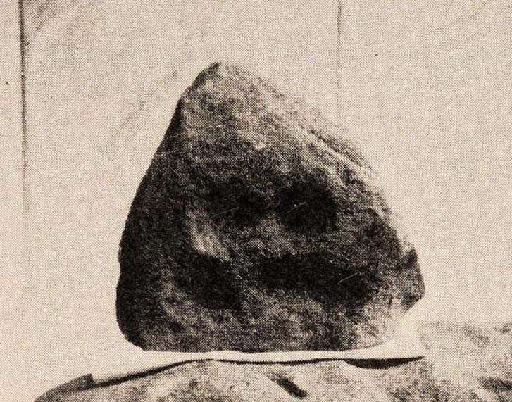
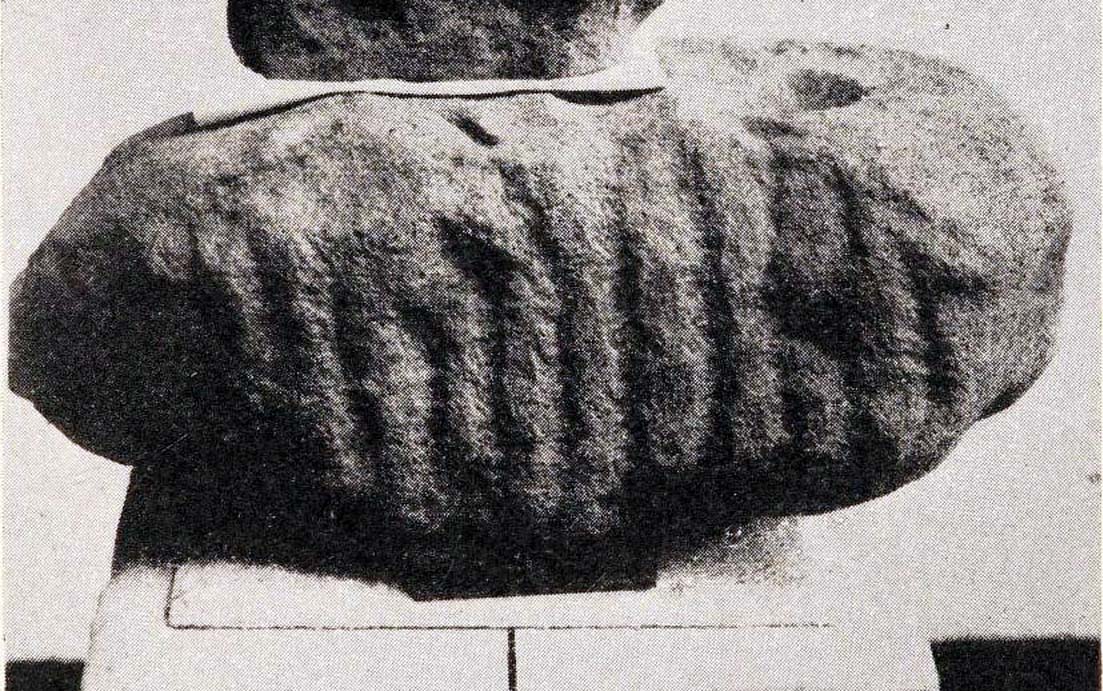
Cup-Marked Stone (destroyed):  OS Grid Reference – NX 0010 5411

Archaeology & History

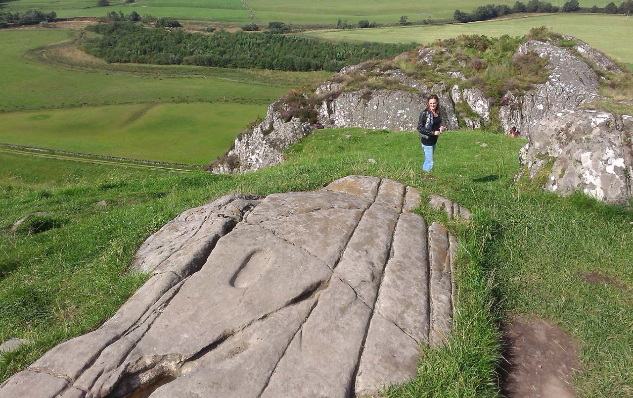
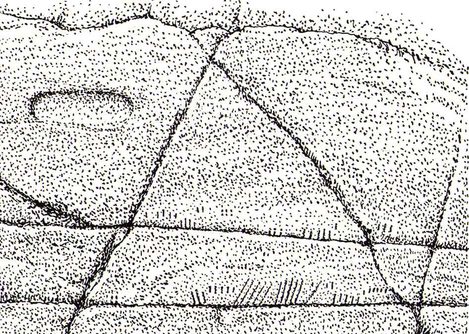
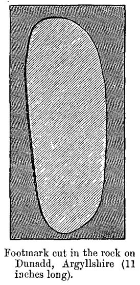
Very little is known about this long-lost carving, whose primary information comes from the folklore records.  Apparently it was found on a rock a short distance south of the destroyed St. Patrick’s Well and the two sites seem to have had a traditional relationship with each other.  The carving had a foot-shaped motif on the rock, and a number of other cup-markings; but I can find no account as to whether the ‘foot’ carving possessed ‘toes’, as seen on the impressive Cochno Stone, north of Glasgow.  It may have been little more that the petroglyphic ‘feet’ seen on the recently discovered and aptly-named Footprint Stone, or those on the newly rediscovered Witches Stone; but we cannot discount it being larger, like the Footprint Stone of Dunadd.  If we could locate an early sketch of the stone, all would be revealed!   Sadly, as E.M.H. M’Kerlie (1916) told us,

“this rock was blasted at the time when the government essayed to make the harbour one of great importance”,

several years after the nearby holy well had been re-routed. Fucking idiots!  Any further info on this site would be most welcome.

Folklore

The local story that was told about St. Patrick creating these carvings seems to have been described first of all by Andrew Agnew (1864), who wrote:

“Once, when about to revisit his native land, he crossed the Channel at a stride, leaving the mark of his foot distinctly impressed on one of the rocks of the harbour; unfortunately, in making a new jetty, this interesting memento was destroyed.”

(The mention of the jetty would seem to imply that the carving was closer to the sea than the grid-reference cited above.) In another tale, St. Patrick rested his hand onto the same rock and the marks of his hand and fingers were left there.  This folklore motif is found across the world.  It relates to cosmological creation myths of indigenous spirits and deities in the tribes and cultures who narrate it.  In this instance, the myth of St Patrick replaced a much earlier mythic tale of another giant or deity, whose name we have lost.  Unless, of course, such petroglyphs were still being carved in Galloway by local people in the 4th-5th centuries.

A further tale of St Patrick, at Portpatrick, replaced a quite obvious shamanistic tale. When he journeyed back from Ireland to Galloway, Agnew again told us:

“Having preached to an assembly on the borders of Ayrshire, the barbarous people seized him, and, amidst shouts of savage glee, struck his head from his body in Glenapp.  The good man submitted meekly to the operation; but no sooner was it over than he picked up his own head, and, passing through the crowd, walked back to Portpatrick, but finding no boat ready to sail he boldly breasted the waves and swam across to the opposite shore, where he safely arrived (according to the unanimous testimony of Irishmen innumerable), holding his head between his teeth!”

Legends such this are found in shamanistic pantheons worldwide.  Shamans primary renown is their ability to travel and recover from the Lands of the Dead, always journeying into impossible and inhospitable arenas, with tales of being dismembered, beheaded, dying, and returning to life to help the tribe with whatever it was that required such a task (usually a healing function).  This story of St Patrick – and many other saints – are mere glosses onto the earlier animistic stories, then abridged as being better, more spiritually mature, more egocentric. But their roots are essentially animistic.

References:

  1. Agnew, Andrew, The Agnews of Lochnaw: The History of the Hereditary Sheriffs of Galloway, A. & C. Black: Edinburgh 1864.
  2. Agnew, Andrew, The Hereditary Sheriffs of Galloway – volume 1, David Douglas: Edinburgh 1893.
  3. Conway, Daniel, “Holy wells in Wigtonshire,” in Archaeological & Historical Collections Relating to Ayr & Wigton, volume 3, 1882.
  4. Harper, Malcolm MacLachan, Rambles in Galloway, Edmonston & Douglas: Edinburgh 1876.
  5. M’Kerlie, E.M.H., Pilgrim Spots in Galloway, Sands: Edinburgh 1916.
  6. MacKinlay, James M., Folklore of Scottish Lochs and Springs, William Hodge: Glasgow 1893.
  7. Morris, Ruth & Frank, Scottish Healing Wells, Alethea: Sandy 1982.
  8. Royal Commission Ancient & Historical Monuments of Scotland, Inventory of Monuments and Constructions in Galloway – County of Wigtown, HMSO: Edinburgh 1912.
  9. Walker, J. Russel, “‘Holy Wells’ in Scotland,” in Proceedings of the Society of Antiquaries of Scotland, vol.17 (New Series, volume 5), 1883.

© Paul BennettThe Northern Antiquarian 


Footprint Stone, Dunadd, Kilmichael Glassary, Argyll

Petroglyph:  OS Grid Reference – NR 83668 93579

Also Known as:

  1. Canmore ID 212008

Getting Here

Footprint Stone in context

From Lochgilphead, take the A816 road north for several miles (towards the megalithic paradise of Kilmartin), keeping your eyes peeled for the road-signs saying “Dunadd.”  Turn left and park-up a few hundred yards down. Go through the gate and walk up Dunadd.  Just before the flattened plateau at the top, a length of smooth stone is accompanied to its side by the deep cup-and-ring of the Dunadd Basin.  Three or four yards away, you’ll see the long ‘footprint’.

Archaeology & History

Near the top of Dunadd’s Iron Age ‘fortress’ and overlooking the megalithic paradise of the Kilmartin valley, several man-made carvings are in evidence very close to each other, all with seemingly differing mythic content.  This one—the footprint—stands out; but it’s not alone!  Faint etchings of at least one other ‘foot’ is clearly visible.  The first literary account of it was by Ardrishaig historian R.J. Mapleton (1860), who told,

“There is on the top of Dunadd a mark that strikes me as interesting; it is like a large axe-head, or a rough outline of a foot.  My impression is that it may have been the spot on which the chief would place his foot when succeeding to the headship of his tribe. The footmark was always considered among the people here as a mould for an axe-head, and I was rather laughed at for suggesting an inaugurating stone.”

Dunadd Footprint (after Royal Commission 1988)
F.W.K. Thomas’ 1879 sketch

Be that as it may, a few years later the carving had caught the attention of the Scottish Society of Antiquaries.  In his article exploring the potential for ritual inaugurations at Dunadd, Captain F.W.L. Thomas (1879) explored, not only the footprint, but the mythic functions of this symbol, looking at parallels with petroglyphs elsewhere in the world where the ‘foot’ was known to be a ritual inauguration symbol (amongst other things).  He gave us the first real detailed account of the carving:

“About 10 or 12 feet below, and to the northward of the highest point, the living rock is smooth, flat and bear of sward, and in it is engraved an impression of a footmark, not of a naked foot, but such as would be made when the foot is clothed by a thick stocking or cuaran… The engravure is for the right foot; and it exactly fitted my right boot.  The footmark is sunk half-an-inch deep, with perpendicular sides, the surface is smoothed or polished, and the outline is regular… It has probably been sheltered by the turf until recently.  The footmark is 11 inches long, nearly 4½ inches broad where broadest, and 3½ inches across at the heel.  When a person stands with his foot in the depression, he looks a little easterly of north.”

A century or so later when the Royal Commission (1988) boys got here, they found not one, but two ‘feet’ carved into the rock!  A few feet away, near to the carved boar,

“At the south end of the main rock surface there is the lightly-pecked outline of a shod right foot. 0.24m long and 0.1m in maximum width, with a pronounced taper to the heel.  There are further peck marks within the outline, and a sunken footmark was intended but not completed.  This print is on almost the same alignment as the more prominent footprint some 2m to the north, which measures 0.27m from NNE to SSW, by 0.1m in maximum width and 25mm in depth.  It is somewhat broader at the heel than the incomplete mark, and its sides are straighter.”

Close-up of the carving

They then emphasize how we’re unable to date the footprints, although point out how such carvings are “found in Britain from the Iron Age onwards.”  But footprints have be found on other petroglyphs in Scotland (much less in England) and date between the neolithic and Bronze Age periods—but whether Dunadd’s example goes that far back, we cannot say.  Extensive excavations occurred at Dunadd between 1980-81 and most of the finds were Iron Age and early medieval in nature (this carving and the cup-and-ring barely got a mention in Lane & Campbell’s [2000] extensive summation).  But we may be looking at an evolutionary developmental relationship in symbolism and form, if the traditions of the place have any substance.  This is something I’ll return to when writing of the Boar Carving, just a few feet away…

Folklore

The legends behind this seemingly insignificant mark near the top of Dunadd ostensibly echo and relate to the huge cup-and-ring of Dunadd Basin four yards away.  I can only repeat what I said in that site profile.

R.J. Mapleton (1860) said that Dunadd was known by local people to be a meeting place of witches and the hill of the fairies, whose amblings in this wondrous landscape are legion. Legends and history intermingle upon and around Dunadd.  Separating one from the other can be troublesome as Irish and Scottish Kings, their families and the druids were here.  One such character was the ever-present Ossian.  Mapleton told:

“From these ancient tales we turn to a much later period of romance, when Finn and his companions had developed into extraordinary and magical proportions; a story is current that when Ossian abode at Dunadd, he was on a day hunting by Lochfyneside; a stag, which his dogs had brought to bay, charged him; Ossian turned and fled. On coming to the hill above Kilmichael village, he leapt clean across the valley to the top of Rudal hill, and a second spring brought him to the top of Dunadd.  But on landing on Dunadd he fell on his knee, and stretched out his hands to prevent himself from falling backwards.  ‘The mark of a right foot is still pointed out on Rudal hill, and that of the left is quite visible on Dunadd, with impressions of the knee and fingers.’”

As Mr Thomas (1879) clarified:

“The footmark is that of the right foot, and the adjacent rock-basin is the fabulous impression of a knee.”

References:

  1. Bord, Janet, Footprints in Stone, Heart of Albion Press 2004.
  2. Campbell, Marion, Mid-Argyll: An Archaeological Guide, Dolphin Press: Glenrothes 1984.
  3. Campbell, M. & Sanderman, M., “Mid-Argyll: An Archaeological Survey,”  in Proceedings of the Society Antiquaries, Scotland, volume 95, 1962.
  4. Craw, J.H. “Excavations at Dunadd and other Sites,” in Proceedings of the Society Antiquaries, Scotland, volume 64, 1930.
  5. Lane, Alan & Campbell, Ewan, Dunadd: An Early Dalriadic Capital, Oxbow: Oxford 2000.
  6. Mapleton, R.J., Handbook for Ardrishaig Crinan Loch Awe and Pass of Brandir, n.p. 1860.
  7. Morris, Ronald W.B., The Prehistoric Rock Art of Argyll, Dolphin Press: Poole 1977.
  8. Royal Commission on the Ancient & Historical Monuments of Scotland, Argyll – Volume 6: Mid-Argyll and Cowal, HMSO: Edinburgh 1988.
  9. Thomas, F.W.K., “Dunadd, Glassary, Argyleshire: The Place of Inauguaration of the Dalriadic Kings,” in Proceedings of the Society Antiquaries, Scotland, volume 13, 1879.

© Paul BennettThe Northern Antiquarian 


Town Cross, Alloa, Clackmannanshire

Cross:  OS Grid Reference – NS 88559 92686

Also Known as:

  1. Burgh Cross
  2. Canmore ID 47169
  3. Market Cross
  4. Mercat Cross

Getting Here

Alloa Cross, Bank Street

Get into the small town of Alloa, where the buses stand at Shillinghill.  From here walk southwest down Mill Street, which runs into Bank Street.  Keep your eyes peeled on your right-hand side, where outside one of the old municipal buildings you’ll see it standing upright.

Archaeology & History

Although now standing against the old buildings halfway down Bank Street, Alloa’s Mercat or Burgh Cross was initially set up at the crossroads 162 yards (148m) away, where Mar Street meets Mill Street and Bank Street.  It was moved to its present position sometime in the 1880s and knowledge of its early history is scant.

John Small’s sketch of Alloa Cross

Standing some 10 feet tall, the monument was described in John Small’s (1900) rare magnum opus, where he details the architectural features of the monument, telling:

“The shaft, which rests on a base and three steps, is of the usual square section, with splayed angles, stoped at top and bottom, the top stop being rather peculiar.  The head of the Cross is composed of an oblong stone set upright, characteristic of the late type seen in Keikleour and Kinrossie.  The oblong is ornamented at the sides with debased volutes and acanthus leaves, the whole crowned by a wreath from which rises a griffin’s head, part of the supporters of the Arms of the Lords of the Manor, Lord Mar and Kellie.”

References:

  1. Anonymous, The Alloa Illustrated Family Almanac, MacGregor & Steedman: Alloa 1887.
  2. Mair, Craig, Mercat Cross and Tolbooth, John Donald: Edinburgh 1988.
  3. Royal Commission on the Ancient & Historical Monuments, Scotland, Inventory of Monuments and Constructions in the Counties of Fife, Kinross and Clackmannan, HMSO: Edinburgh 1933.
  4. Small, John W., Scottish Market Crosses, Eneas Mackay: Stirling 1900.

© Paul BennettThe Northern Antiquarian

The Grey Lady, Lundie, Angus

Standing Stone (destroyed):  OS Grid Reference – NO 3069 3609

Also Known as:

  1. Canmore ID 31894

Getting Here

Grey Lady on 1860 OS-map

The site of the stone is on the top of a ridge due west of Lundie Castle and is best approached from the minor road between Lundie and Denhead, but at the time of my site visit a steel gate had been erected across the field just before the site of the stone together with a large festoon of electric fencing, which I did not cross.

Archaeology & History

The Grey Lady stood on the near grassy horizon

The Ordnance Survey name book describes the stone, the informants being Mr. Pattullo junior and Mr. Bett of Pitermo:

This name is applied to a Standing Stone a little to the west of Lundie Castle. It is about 4 feet high, between two & three broad & rather a Kidney Shape. …Some think of druidical origin, but young Pattullo intends to blast it shortly“.

The rough grass probably marks where she stood.

And indeed it seems the feckless youth did have his wicked way with The Grey Lady, who had been a landmark for millennia, for she sadly no longer exists. In view of the folklore attaching to the stone, it may be worth speculating whether the kidney shape denoted a lunar symbolism for the stone.

Folklore

The OS name book states:

“The ladies of Lundie Castle have romance connected with it – that a white lady is to be seen walking round it on a certain night of every new moon.”

Reference:

  1. Ordnance Survey Name Book; Forfarshire (Angus) volume 66 (1857-61)

© Paul T. Hornby, The Northern Antiquarian 2017


Barton Cross, Barton, Preston, Lancashire

Wayside Cross: OS Grid Reference – SD 53502 37332

Also Known as:

  1. Historic England Grade II Listed Monument 1073555

Getting Here

The Barton Cross from the road, showing the original socketed base and the cup marked paving stone to the right.

The cross is at the roadside on the south side of Barton Lane at the cross roads with the minor road between Cross House Farm and Barton House.

Archaeology and History

All that survives is the socketed base of a mediaeval cross on a raised paved platform with low raised square section pillars at each corner. Behind the original cross socket stands a large stone block (Described in the Historic England citation as “probably part of a cheese press“) surmounted by a pyramidal block upon which a modern carved stone cross has been placed.

Henry Taylor (1906) writes in his Ancient Crosses and Holy Wells of Lancashire:

The South face of the Cross

Barton Cross. These words occur on the map in ancient Gothic letters in Barton Lane, one and a half miles in a westerly direction from Goosnargh Church, showing that in the year 1848 a complete cross stood here. The site is at the intersection of country lanes, and the map shows a small recess or lay-bye in which the cross was planted. Mr. Collinson [Reverend S.E. Collinson, Vicar of Broughton] writes that the base was thrown into a neighbouring pit at the time Daniel’s pedestal was buried. The base and part of the shaft of the Barton Cross have lately been restored to the old site. A new cross has been erected just behind by Mr. Myerscough.
Mr. Collinson tells me that in going through some of the old parish registers he found an entry referring to ‘Barton Christ’. He not unnaturally thinks that there must have been a figure on the Cross giving rise to the name. Nothing else would account for it. The neighbourhood of Barton (a pre-Norman settlement) is interesting and deserves a thorough investigation.

The ‘Daniel’s pedestal’ refers to Daniels Cross, near Broughton, of which Taylor writes:

The base was removed about sixty years ago. It is now in a neighbouring pit. The facts were obtained from an old man who helped at the destruction of this landmark.”

The 1895 6″ map showing the Cross, with the nearby marl-pits coloured blue

The pyramidal stone block upon which the modern cross stands is inscribed on the northern face: “Barton Cross re-erected by Councillor R. Myerscough of Preston 1901” while the southern face is inscribed: “Refurbished by Barton Parish council 2000“.

One of the paving stones that surround the cross has pre-historic cup markings on it, and is the subject of a separate site profile.

Bearing in mind what was written about the original cross having been ‘thrown into a neighbouring pit’, it may be worth probing the nearby marl pits to see whether the original could be found.

Reference:

  1. Taylor, Henry, The Ancient Crosses and Holy Wells of Lancashire, Manchester, Sherratt and Hughes, 1906

© Paul T. Hornby, The Northern Antiquarian 2017


Cow Keeper’s Field (1), Boulby, Easington, North Yorkshire

Cup-Marked Stone:  OS Grid Reference – NZ 75398 19218

Also Known as:

  1. BOU-5 (Brown & Chappell)

Archaeology & History

Cup-marked stone inside Cow keepers Field tomb

Inside the once prominent prehistoric tomb on the Cow Keeper’s Field, the northern antiquarians William Hornsby and John Laverick (1920) came across two small petroglyphs in association with a cremation burial, several feet south of the central cist: the Cow Keeper’s Field 2 carving, plus this small, triangular-shaped stone, 8in by 6in, consisting of five standard cup-marks, with two of the cups (as the photo shows) connected to each other.  It is akin to the numerous ‘portable’ cup-marked stones which, in other cultures, were deposited onto cairns in remembrance of the ancestral spirits of the tomb.  Such widespread practices may also have occurred here.  Petroglyph researcher and writer Graeme Chappell (2017) informed us that the carving “is in storage in the Dorman museum in Middlesborough.”

References:

  1. Brown, Paul & Chappell, Graeme, Prehistoric Rock Art in the North York Moors, Tempus: Stroud 2005.
  2. Chappell, Graeme, Personal communication, October 4, 2017.
  3. Crawford, G.M., Bronze Age Burial Mounds in Cleveland, Cleveland County Council 1990.
  4. Elgee, Frank, Early Man in North-East Yorkshire, John Bellows: Gloucester 1930.
  5. Hornsby, William & Laverick, John D., “British Barrows round Boulby,” in Yorkshire Archaeological Journal, volume 25, 1920.

© Paul BennettThe Northern Antiquarian 


Cow Keeper’s Field (2), Boulby, Easington, North Yorkshire

Cup-and-Line Stone:  OS Grid Reference – NZ 75402 19222

Also Known as:

  1. BOU-5 (Brown & Chappell)

Archaeology & History

Cup-marks and linear forms

Inside the once prominent prehistoric tumulus on the Cow Keeper’s Field (now destroyed), the northern antiquarians William Hornsby and John Laverick (1920) came across two small portable petroglyphs: the Cow Keeper’s Field 1 carving, plus this “peculiarly marked stone” as they put it, some “5ft south of the centre” where a cist, or stone-lined burial existed.  Measuring 18in by 7in, the rock carving consists of at least one large cup-marking which is clearly evident on top of the stone, plus what seems to be another one next to it, half-covered.  Along the side of the stone, a series of twelve roughly parallel lines have been carved out, running down to the bottom of the stone.  Rock art researcher and writer Graeme Chappell (2017) tells us the carving is supposed to be “in storage in the Dorman museum in Middlesborough,” although no one has seen it in years.  It would be worthwhile if fellow research students could visit the said museum to recover this and other portable cup-marked stones that were found in the area.

References:

  1. Brown, Paul & Chappell, Graeme, Prehistoric Rock Art in the North York Moors, Tempus: Stroud 2005.
  2. Chappell, Graeme, Personal communication, October 4, 2017.
  3. Crawford, G.M., Bronze Age Burial Mounds in Cleveland, Cleveland County Council 1990.
  4. Elgee, Frank, Early Man in North-East Yorkshire, John Bellows: Gloucester 1930.
  5. Hornsby, William & Laverick, John D., “British Barrows round Boulby,” in Yorkshire Archaeological Journal, volume 25, 1920.

© Paul BennettThe Northern Antiquarian


Cow Keepers Field, Boulby, Easington, North Yorkshire

Tumulus (destroyed):  OS Grid Reference – NZ 75400 19220

Also Known as:

  1. Boulby Barns

Archaeology & History

This prehistoric tomb was one in a cluster of tumuli in the Boulby district, uncovered by the northern antiquarians, William Hornsby and John Laverick in 1918.   Most of them have subsequently been destroyed – this one included.  When they visited the site, they described it as “a barrow…with a diameter of 36 feet.”  Once they began digging into it,

“at the centre we found a cist, the top of which was 2ft 7in below the present surface. The cist lay north 64° west, and south 64° east.  It had no cover and the slab at the north-west end was wanting.  The cist measured: side 3ft 6in, end 3ft 2in.  Its depth was 2ft 2in.  In it we found nothing except sandstone chips.  With these there was no admixture of soil. Above the cist and covering a space of 5 ft by 5 ft there was a layer of burnt earth and black ashes (of furze bushes).  At a distance of 5 ft south of the centre, and 1ft 10in below the present surface, there was a burnt burial, 20in in diameter.  With this we found many flint chips, a shale pendant, and the peculiarly marked stone” we’ve called, simply the Cow Keeper’s Field 2 carving.

A second cup-marked stone was also found inside the tomb, a few feet south of the cist. When G.M. Crawford went to survey the burial mound in the late 1970s, he reported “there is no trace of it” and “has probably been destroyed by ploughing.”

References:

  1. Brown, Paul & Chappell, Graeme, Prehistoric Rock Art in the North York Moors, Tempus: Stroud 2005.
  2. Crawford, G.M., Bronze Age Burial Mounds in Cleveland, Cleveland County Council 1990.
  3. Elgee, Frank, Early Man in North-East Yorkshire, John Bellows: Gloucester 1930.
  4. Hornsby, William & Laverick, John D., “British Barrows round Boulby,” in Yorkshire Archaeological Journal, volume 25, 1920.

© Paul BennettThe Northern Antiquarian 


The Falls (1), Boulby, Easington, North Yorkshire

Cairn:  OS Grid Reference – NZ 74954 19429

Also Known as:

  1. Rockcliff Beacon

Archaeology & History

Tumulus on 1920 map

Occupying a prominent position above the ever-closer North Sea, upon which an old beacon was subsequently placed, this denuded prehistoric tomb was first surveyed by the Ordnance Survey lads in 1913, and subsequently in an essay by Messers Hornsby & Laverick (1920) on the ancient sites of Boulby, east of Easington.  This was the first one they explored, calling it ‘Mound No.1.”  They located it,

“due south of the ‘Soldier’s Garth’ in the east corner of the field called The Falls.  It was a cairn with a diameter of 50ft.  Two-and-a-half feet northwest of the centre peg, at a depth of 21 inches below the present surface, there was an unaccompanied burnt burial, which occupied a space of 15in by 18in.  In a centre cut 7ft 6in by 6ft, at a depth of 3ft 6in, we found much burnt bone and many potsherds of the Bronze Age type, scattered over the whole space of the trench, down to a further depth of 3ft 10½in.  In the south corner there were four stones set on edge and running in a direct (straight) line.  The interment had been placed upon the clay, the soil of the original surface having been cleaned off.  With this burial we found a good flint made from a polished celt and worn smooth at the point—possibly through having been used for striking fire on iron pyrites—many chips and several cupstones.”

The “several” cup-marked stones they describe at the end seem to have been lost; perhaps sleeping in some museum cellar somewhere (does anyone know?).

This cairn was one in a complex of eight that Frank Elgee (1930) suggested may have been laid out deliberately in the form of the constellation of Ursa Major, or The Plough, also known as ‘Charles Wain’.

References:

  1. Brown, Paul & Chappell, Graeme, Prehistoric Rock Art in the North York Moors, Tempus: Stroud 2005.
  2. Crawford, G.M., Bronze Age Burial Mounds in Cleveland, Cleveland County Council 1990.
  3. Elgee, Frank, Early Man in North-East Yorkshire, John Bellows: Gloucester 1930.
  4. Hornsby, William & Laverick, John D., “British Barrows round Boulby,” in Yorkshire Archaeological Journal, volume 25, 1920.

© Paul BennettThe Northern Antiquarian 


Handsome Cross Circle, High Bradfield, South Yorkshire

Stone Circle (destroyed):  OS Grid Reference – SK 26 94

Archaeology & History

This lost ring of stones was one many sites that could once be found in this area.  It was written about in John Watson’s (1776) essay on the local antiquities, where, in describing places he thought were druidical remains (like the prehistoric Bar Dike and Apronful of Stones cairn), he told that

“There is something also of this sort on the other side of Bardike on Bradfield Common; in particular a circle of about eight yards diameter composed of twelve stones, and a confused heap in the centre, near Handsome Cross, and the faint remains of two larger not far off.”

Subsequent local historians like Joseph Hunter (1819) and Harold Armitage (1939) mention the place, with Armitage giving the impression that remains of it could be seen in his lifetime, but today we are at a loss to known its exact position and nature.  By the sound of Watson’s initial description, this circle sounded as if a cairn of some sort was in the centre, giving it more a funerary nature than an open stone circle.  But we don’t know for certain. This is also what John Barnatt (1990) posited in his local survey.

Based on the landscape, an initial analysis would place the circle most probably at SK 2615 9424, close to where the Handsome Cross itself stood—but this is conjectural.  The natural landscape hereby has been ruined by extensive farming and forestry, so any remains of it seem improbable.

References:

  1. Armitage, Harold, Early Man in Hallamshire, Sampson Low: London 1939.
  2. Barnatt, John, Stone Circles of Britain – volume 2, BAR: Oxford 1989.
  3. Barnatt, John, The Henges, Stone Circles and Ringcairns of the Peak District, University of Sheffield 1990.
  4. Hunter, Joseph, Hallamshire: The History and Topography of the Parish of Sheffield, Lackington: London 1819.
  5. Morgan, Paul & Vicki, Rock around the Peak, Sigma 2001.
  6. Smith, A.H., The Place-Names of the West Riding of Yorkshire – volume 1, Cambridge University Press 1961.
  7. Watson, John, “An Account of some Hitherto Undescribed Remains of Antiquity“, in Archaeologia, volume 5, 1776.

© Paul Bennett, The Northern Antiquarian