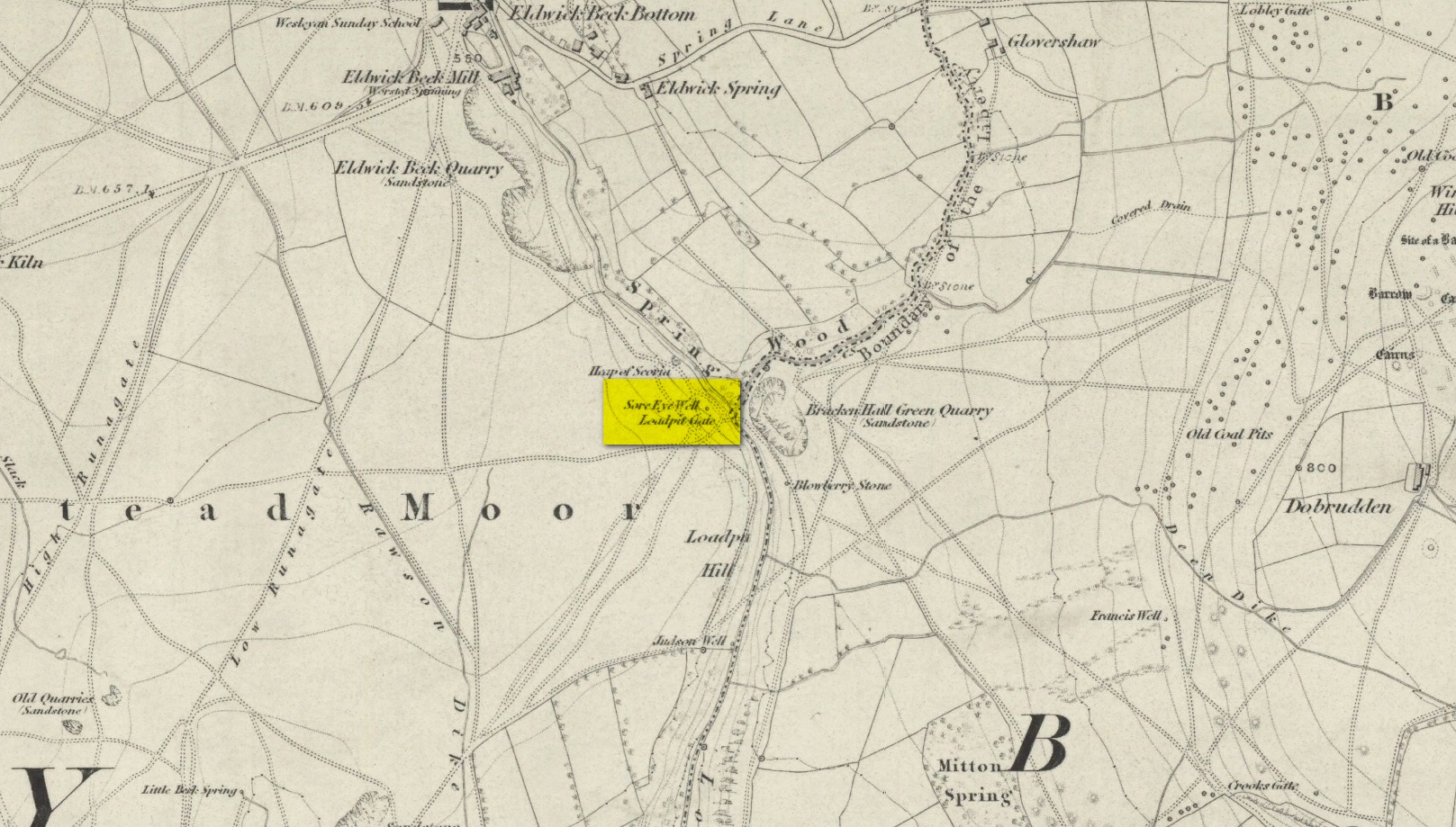
Healing Well (destroyed): OS Grid Reference – SE 1286 4007
Also Known as:
Loadpit Well
Archaeology & History
Sore Eye Well on 1852 map
Descriptions of this site are few and far between, despite it having a meaningful name. First recorded on the 1852 OS-map, in the folklore of our ancestors this was a well that local people frequented to wash their face and it was said that the waters would take away the ills of those suffering poor eyesight or other ocular problems. Rags were left hanging over an old rowan tree as offerings to the spirit of the water, in return for curing the afflicted eyes.
When I first came looking for this as a boy, I was frustrated to encounter the water authority’s metal cover ruining the site completely, leaving nothing of the old well as it once was. Around the metal-cover was evidence of a small rock enclave that would have defined the spring as it emerged from the earth—although it was barely noticeable. The remnants of a small path just to the right of the main footpath that reaches up the hillside is apparent, leading to the well. Below it were the remains of a large, water-worn flat rock, with other stones set to its sides, where the water used to flow and be collected, but today everything’s dried up and there’s little evidence of it ever being here.
References:
Shepherd, V., Historic Wells in and Around Bradford, Heart of Albion: Wymeswold 1994.
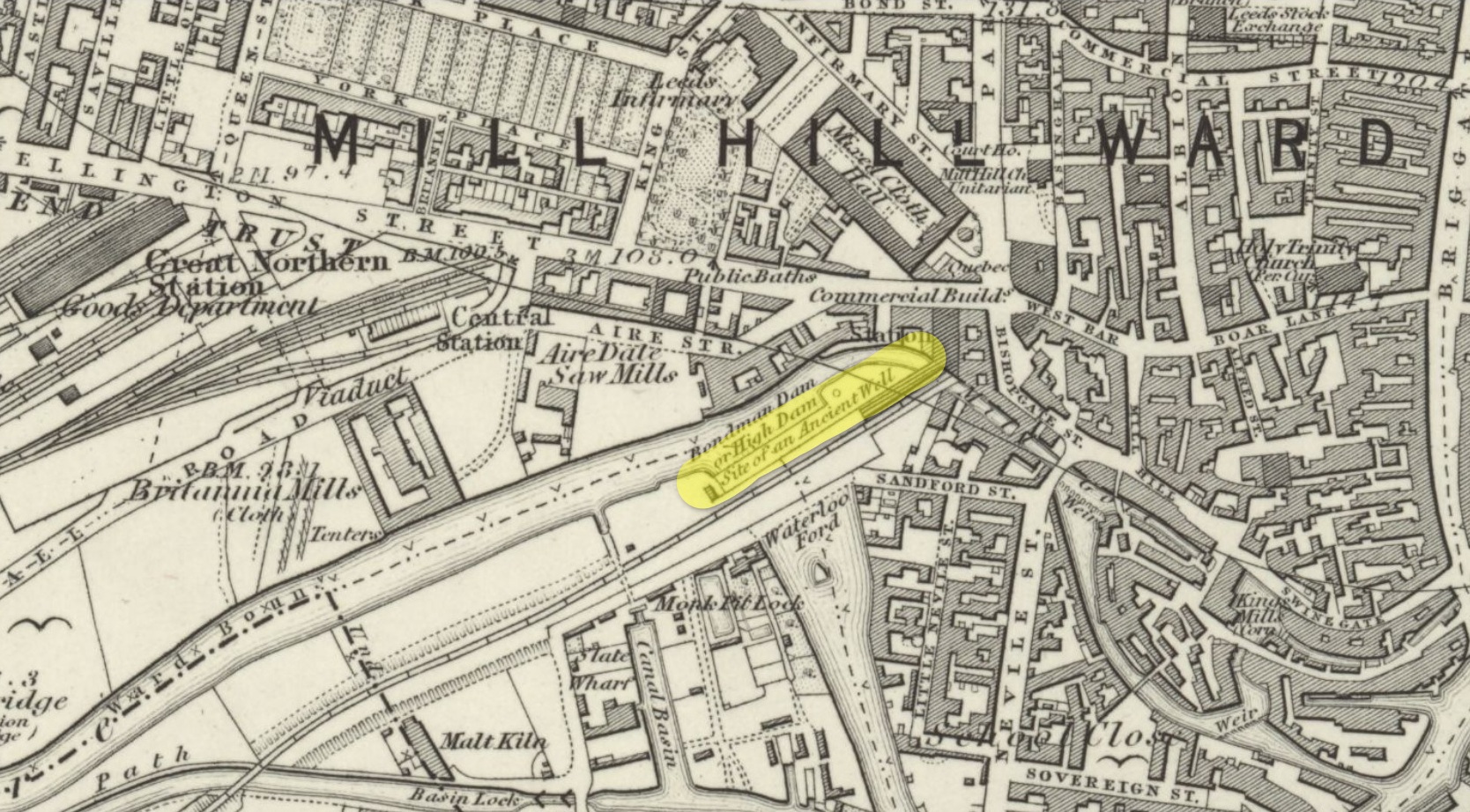
Healing Well (destroyed): OS Grid Reference – SE 2986 3331
Archaeology & History
First mentioned in the 1715 magnum opus of Ralph Thoresby, this old healing well has long since fallen victim to the careless Industrialists. In his day, the well was there for all to use, saying:
“Eye-bright Well on a declining Ground, near the Monk-Pits, discovers its Virtues in the Name, being, long-ago, esteemed a Sovereign Remedy against Sore-Eyes.”
This note was subsequently copied in in Hope’s (1893) classic survey, with no additional comment. In all probability, the name of the well derived from the presence of the herb Eyebright (Euphrasia officinalis) which, as is well known, is the best herb for ailments of the eye. The water from the well, in combination with the herb that grew around it, no doubt increased its ocular healing abilities.
By the middle of the 19th century, the rise of Leeds city brought an end to its ancient flow and its location was eventually forgotten. In Bonser’s (1979) survey of Leeds’ wells, he told how,
“the position of this well can be accurately determined: it was situated on sloping ground between Wellington Street and Aire Street, as clearly indicated on the 1847 (1850) OS 5ft to 1 mile (map).”
Location of Eyebright Well on 1852 map
However, in the much earlier survey of Leeds, Edward Parsons (1834) told us that this well was a hundred yards to the south, “near the line of the new road to the iron bridge across the Aire at the Monk Pits.” And although it isn’t named, it should be noted that immediately across the River Aire, where Parsons stated, the 1852 OS-maps showed the “Site of an Ancient Well.” This is very likely to be where it was. Parson’s also echoed the local lore of the time, telling us that the Well was “a sovereign remedy for soreness of the eyes.”
References:
Bonser, K.J., “Spas, Wells and Springs of Leeds,” in The Thoresby Miscellany – volume 16, Leeds 1979.
Hope, Robert Charles, Legendary Lore of the Holy Wells of England, Elliott Stock: London 1893.
Parsons, Edward, The Civil, Ecclesiastical, Literary, Commercial and Miscellaneous History of Leeds, Halifax, Huddersfield, Bradford, Wakefield, Dewsbury, Otley – volume 1, Frederick Hobson: Leeds 1834.
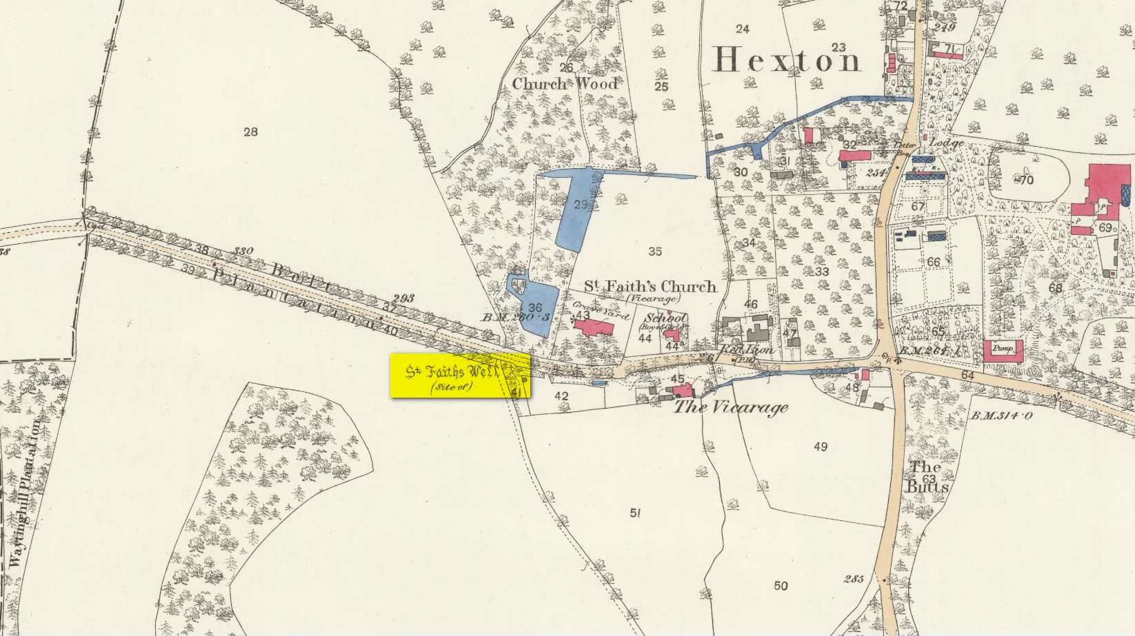
Holy Well (destroyed): OS Grid Reference – TL 10302 30328
Also Known as:
Hertfordshire Historic Environment Record No. 1926
Archaeology & History
The site of the well is now in the garden of a house on the south side of the B655 Barton Road in Hexton, south west of St Faith’s church. Prior to the Reformation, there was a small chapel of St Faith adjacent to the well containing a shrine to the saint, which was, with the well a place of pilgrimage.
N. Salmon, writing in 1728, told us:
St Faiths Well on 1882 map
“At Ravensborough, within a Quarter of a Mile, is a fine Spring, which runs down to Hexton, and meets there another Stream rising at the Berystede near the church, which is indeed a very remarkable one. It comes pouring out of the Earth in such plenty, that it would turn a Mill in a very little Way; and hath been since the Roman Times thought worthy of a Saint’s Name. It was called St Faith’s Well, to which the church also is dedicated, and the Image of St Faith was placed over it.”
The well is just to the north of the iron age hill fort of Ravensburgh and near the ancient prehistoric roadway of Icknield Way, so would certainly have been a welcome stopping point for prehistoric travellers in these chalk uplands. In line with Salmon’s contention of its having been known since Roman times, Francis Taverner, the 17th century Lord of the Manor of Hexton wrote of the well having been used for oracular purposes by people who would throw an object onto the surface of the water:
“which if swamme above they were accepted and there petition granted, but if it sinke, then rejected which the experienced Prieste had arts enove to cause to swymme or sinke according as himselfe was pleased with the partye, or rather with the offering made by the partye.”
St Faith who was a third century martyr who was beheaded at Agen in Gaul. Her saint’s day is 6th October, and her patronage was invoked inter alia by pilgrims, so the dedication of the well and nearby church may have been to ‘christianise’ a pre-existing oracular place resorted to by travellers on the Icknield Way.
Taverner again:
“There is a small parcel of ground adjoining the churchyard called “St. Ffaith’s Wick Court,” about a pole in measurement, anciently divided from Malewick by a ditch in the same place where now a large moat is made. The greatest parte of this Wick lying upon a bedde of springs, and undrained, was very boggye towards the churchyard; but the west side being higher, the ground was well planted with oaks, willows, and bushes, near adjoyning unto which, the craftye Priests had made a well about a yard deepe, and very cleere in the bottome, and curbed about, which they called St. Faith’s Well.
“Now over this well they built an howse, and in the howse they placed the image or statue of St. Faith, and a cawsey they had mad (which I found when I digged and levelled the ground) for the people to passe who resorted thither from farr and neere to visitt our Lady, and to performe their devotions reverently, kissing a fine-colloured stone placed in her toe. This Lady was trimly apparelled, and I find in an old book of churchwarden’s accounts, in the reign of Henry VIII, that they had delivered unto the St. Ffaith a cote and a velvet tippet. The Lady had no land to maintain her, that I know of, more than i acre lying in Mill Field, called at this day St. Ffaith’s acre, which, as being given to superstitious uses, came to the King’s hands at the dissolution, and is now parcel of the demesnes. The house being pulled down, and the idol cast away, the well was filled up, yet an apparent mention of the place remained till my time, and St. Ffaith’s Well continued as a waste and unprofitable and neglected piece of land till such time as the footpath was turned through the midst of it to the outside on the south by the highway, and their clearing and levelling the ground, having been drained, and sunk the spring, I converted the same, in the year of our Lord 1624, into a little orchard. The Lady Ffaith was a Virgin and Martyr of Agenne, in France, a.d. 1290.”
The well may have had healing properties too. Herbert Tompkins (1902) informed us how,
“…to folk who have never stepped out of Hertfordshire (I have known several such) the well of St. Faith is indeed the “Well at the World’s End.” The waters of that well were of miraculous efficacy, and an image of its saint was long preserved in the chapel of St. Faith Virgin, of which no stone remains.”
The parish church of Hexton remains dedicated to St Faith , as does the parish church of nearby Kelshall. There was another St Faith’s Well at Leven in East Yorkshire.
References:
Clutterbuck, Robert, History & Antiquities of the County of Hertford – volume 3, Nichols Son & Bentley: London 1827.
Farmer, David Hugh, Oxford Dictionary of Saints, Oxford University Press 1987.
Hippisley-cox, R., The Green Roads of England, 6th Edition, Methuen: London 1948.
Hope, Robert c., Legendary Lore of the Holy Wells of England, Elliot Stock: London 1893.
Johnson, Walter, Folk Memory or the Continuity of British Archaeology, Clarendon Press: Oxford 1908.
Jones-Baker, Doris, Old Hertfordshire Calendar, Phillimore: Chichester 1974.
Salmon, N., History of Hertfordshire, London, 1728.
Tompkins, Herbert W., Highways & Byways of Hertfordshire, Macmillan: London 1902.
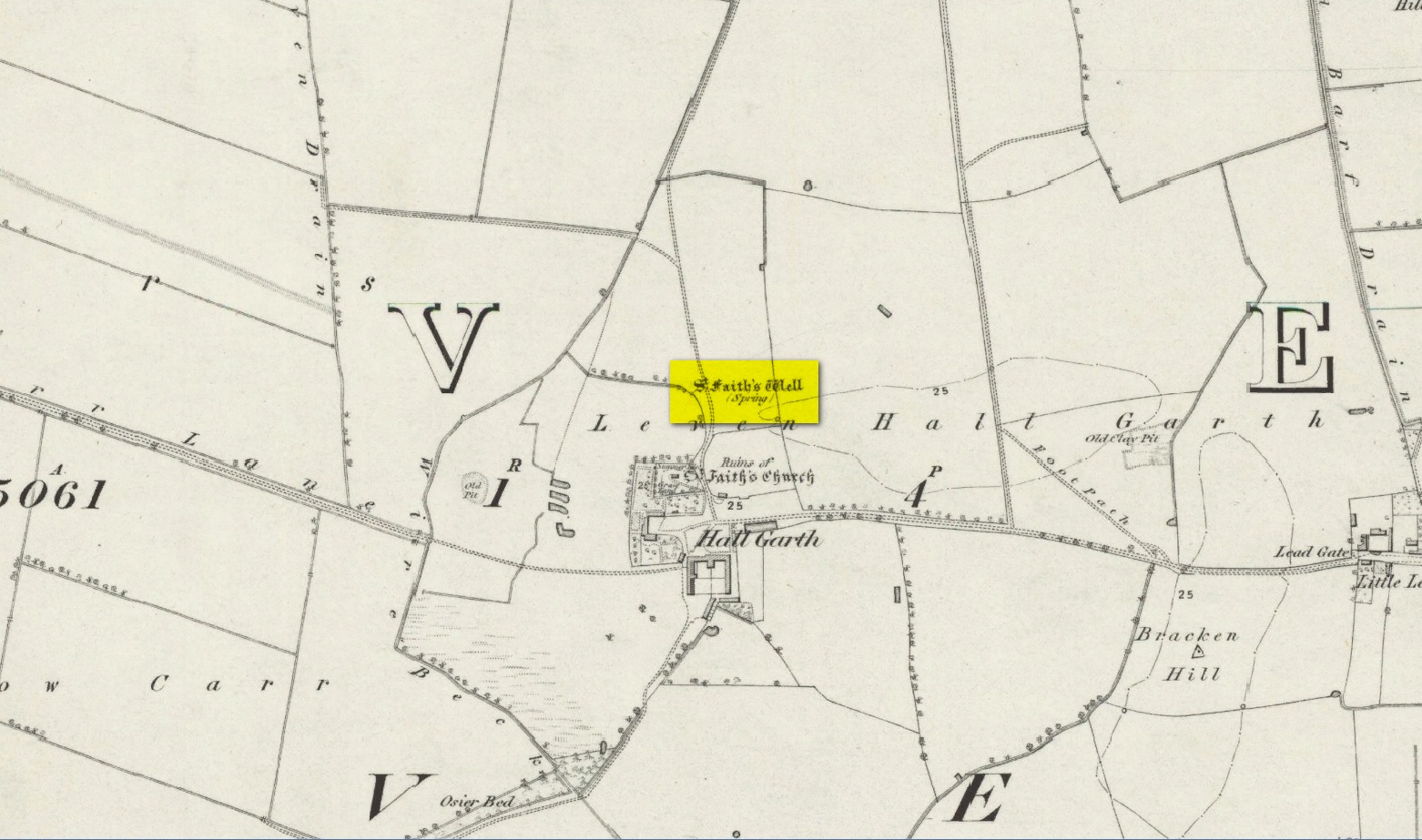
The site of the well is on the Carrs to the west of Leven village, immediately north of the old cemetery adjoining Hall Garth house. Reverend William Smith, writing in 1923, told us:
St Faiths Well on 1855 map
“St Faith’s Well lay on the left of the road known as St Faith’s Lane, which leads to the old churchyard to which the spring was near. St Faith belonged to France, and when quite a young maiden, was martyred because of her christianity. She lived and died in the third century….
“St Faith’s Well was filled in about a hundred years ago and the site lost. This, however, has lately been approximately fixed by the aid of water divining. A Leven man, who can wield the hazel wand, went over the ground near to which the well was thought to have been, and the wand indicated a spot under which, on digging to the depth of about three feet, “the water fairly bubbled up”, and it was judged this was the place where the well lay. St Faith’s Well is said to have given water both pure and abundant, and to have been in the old days the only supply of drinking water to the people of the Carrs.”
St Faith’s Saint’s day is the 6th October and she was a saint whose patronage was invoked by pilgrims, prisoners and soldiers. From this, is it perhaps reasonable to infer that St Faith’s Well may have been a station for pilgrims to the local shrines of St John of Beverley and St Philip Ingleberd at Keyingham? Also a stopping point for fugitives seeking sanctuary at Beverley?
There was another holy well dedicated to St Faith at Hexton in north Hertfordshire.
References:
Cox, J.Charles, The Sanctuaries & Sanctuary Seekers of Mediæval England, George Allen: London 1911.
Farmer, David H., Oxford Dictionary of Saints, Oxford University Press: Oxford 1987.
Smith, Rev. William, Ancient Springs & Streams of the East Riding of Yorkshire, A. Brown: Hull 1923.
The earliest OS-map of this area shows this well a hundred yards or so northwest of an old church and just a few yards east of the stream that is now in woodland; but unlike today, when the early survey was done there were no trees, enabling a clear view of the waters. When Myles Ronan (1927) wrote of the place, he told that it was still visible. The site was added to the Grogan & Kilfeather (1997) county inventory where they suggested it’s probable relationship with the legendary St Brigid. This seems highly probable. Does anyone know if the Well is still there?
References:
Grogan, Eion & Kilfeather, Annaba, Archaeological Inventory of County Wicklow, Stationery Office: Dublin 1997.
Ronan, Myles V., “The Ancient Churches of the Deanery of Arklow”, in Journal Royal Society Antiquaries, Ireland, December 1927.
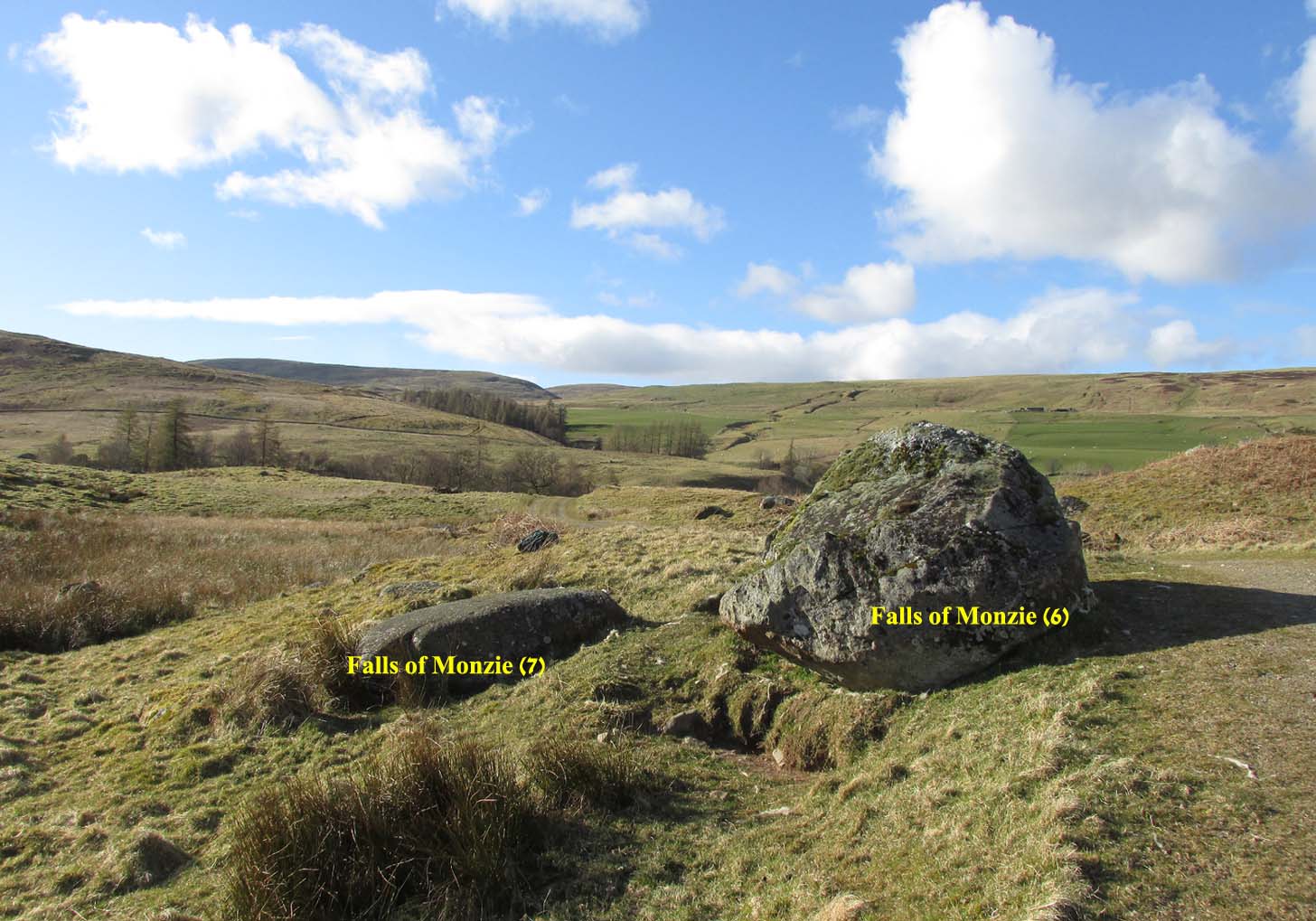
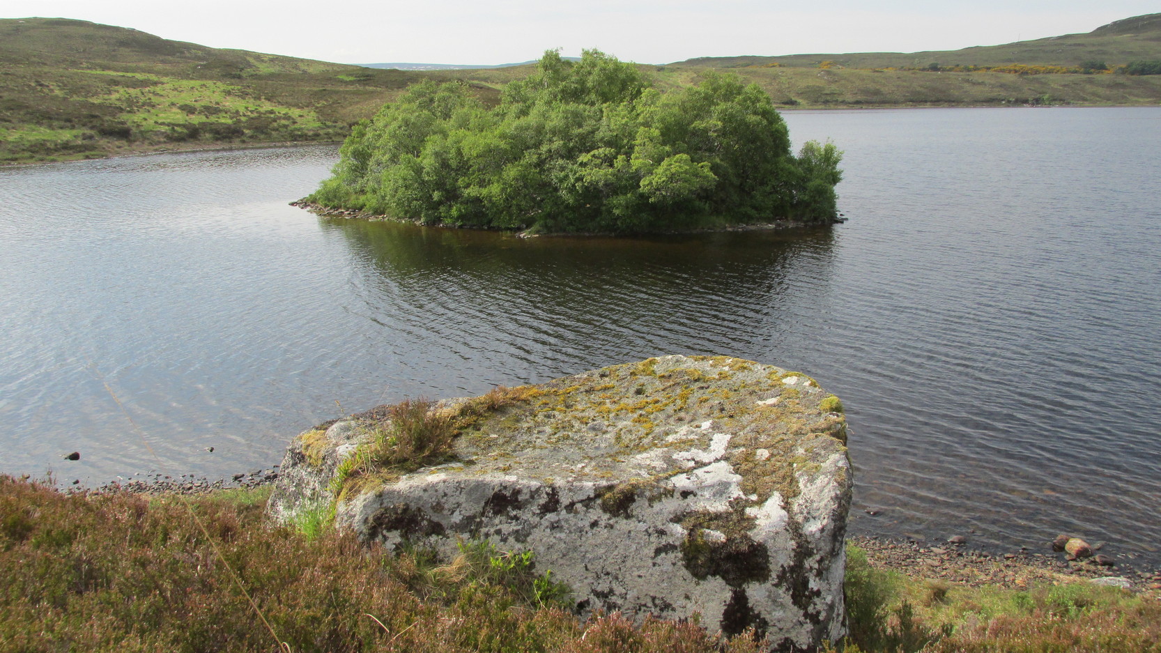
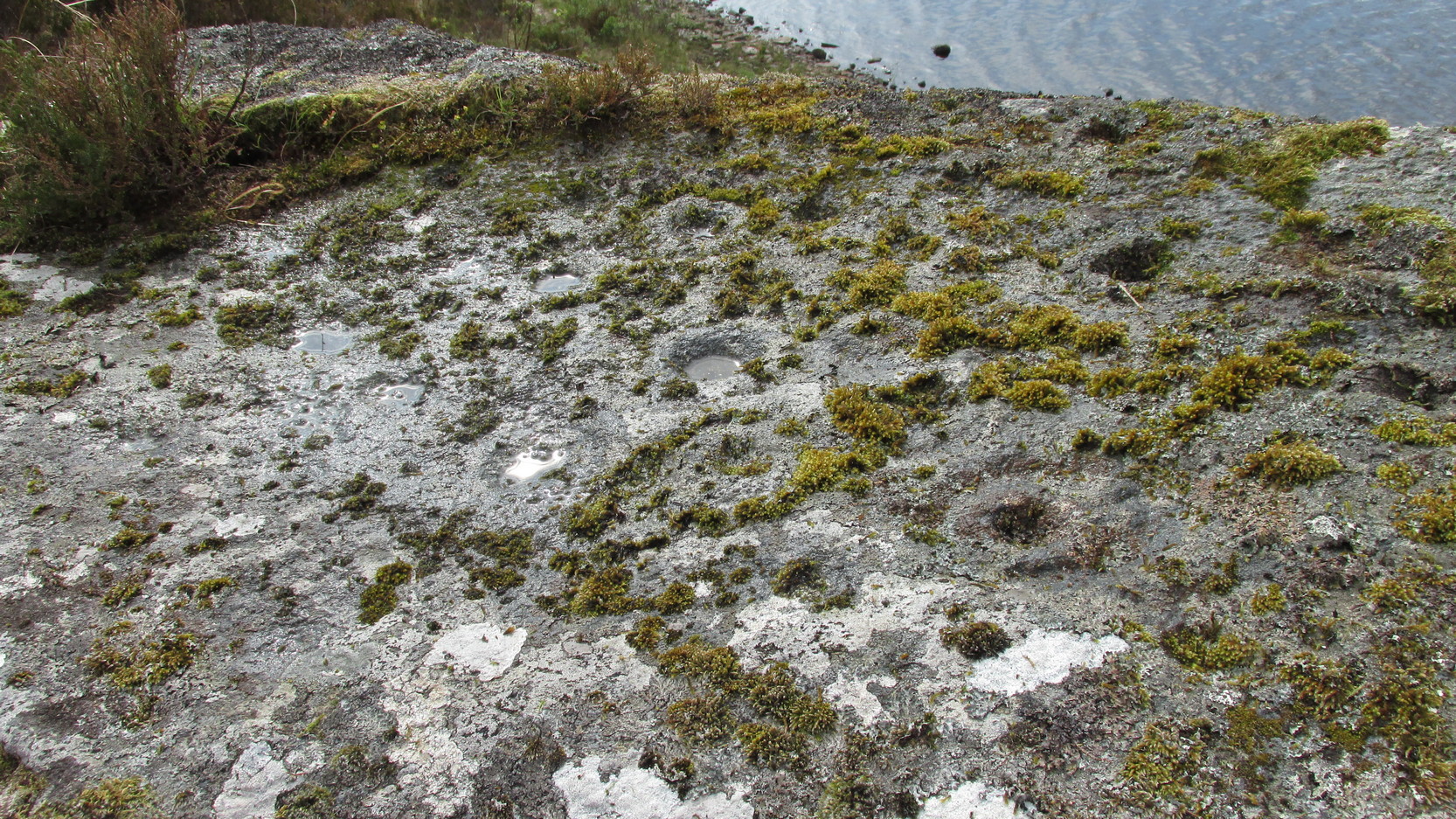
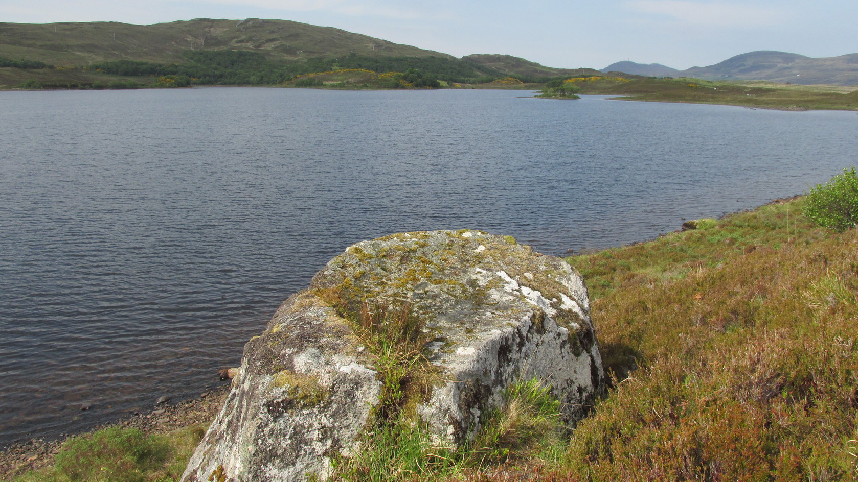
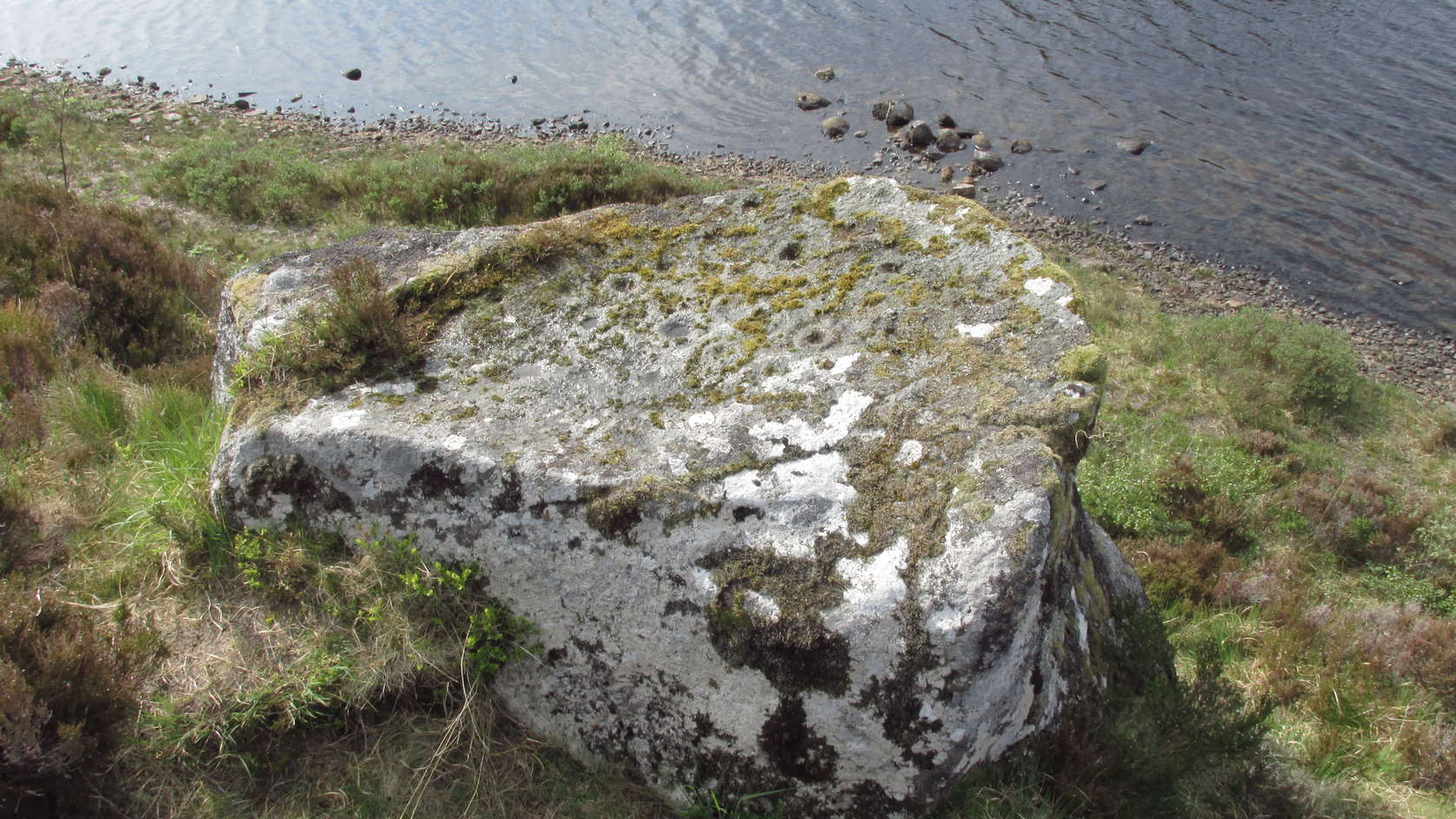
A couple of miles east of Crieff, take the A822 road from the Gilmerton junction towards the Sma’ Glen. After literally 1¾ miles (2.8km)—just 100 yards before the track up to Connachan Farm—you’ll reach a dirt-track on your left that leads into the hills. Go on here and after an easy walk of 400 yards or so, you’ll reach a conspicuous large boulder just by the track-side, on your left. It’s impossible to miss!
Archaeology & History
Immediately adjacent to the Falls of Monzie (7) carving, this petroglyph was located by Paul Hornby on a recent visit to the Falls of Monzie cluster.
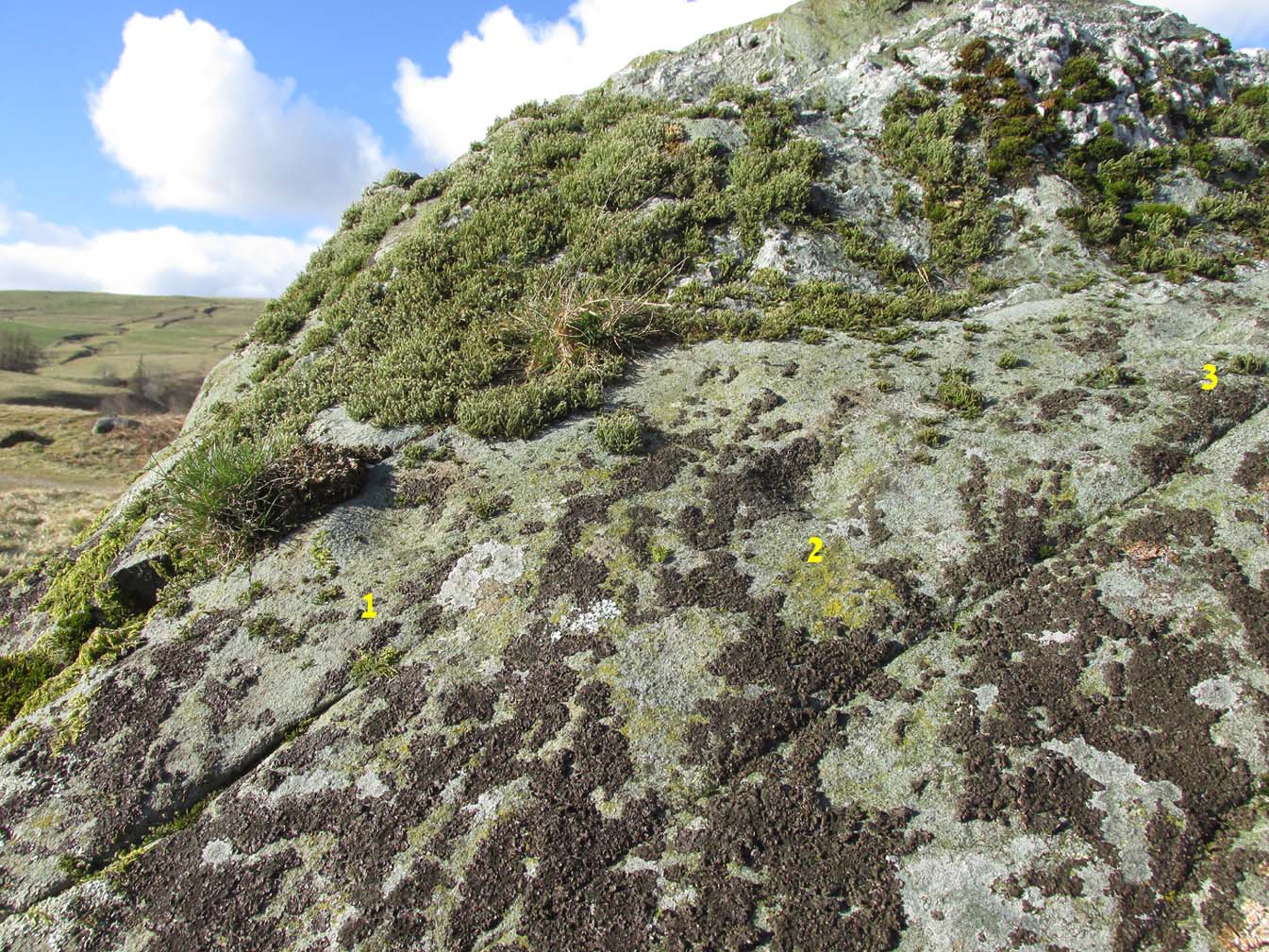
The 3 cups numerated
More than halfway up its south-sloping face are two very distinct cup-marks, some two inches across and up to half-inch deep: one near the western-edge and the other closer to the middle of the rock face. You can’t really miss them. They seem to be accompanied by a third about 2 feet further across to the right on its more eastern side. In formation, the three of them form a small raised arc. With the naked eye they’re very easy to make out, but were difficult to photograph due to the daylight and angle of the stone; hence in the photo here, I’ve numerated them.
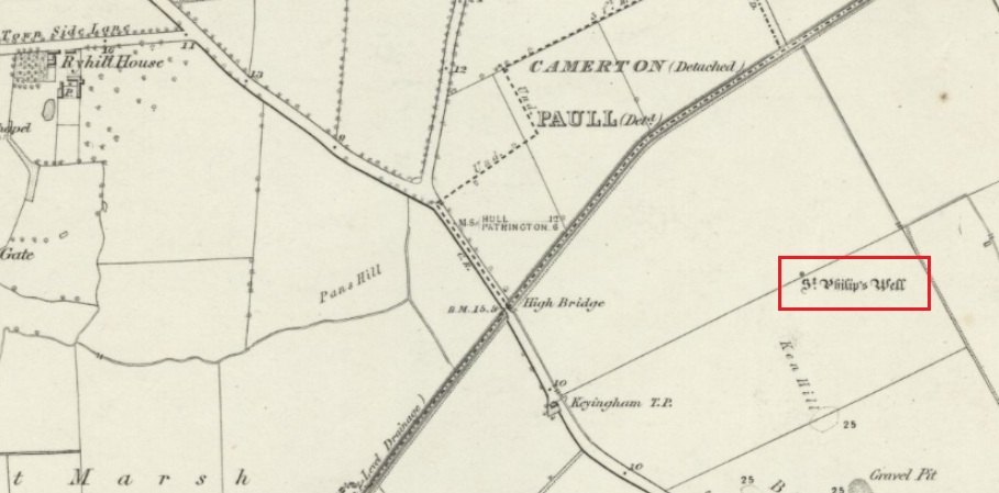
Holy Well (destroyed): OS Grid Reference – TA 23584 25549
Archaeology & History
The Well shown on the 1855 6″ OS map
This holy well was formerly on the northern boundary of a field adjoining the north side of the A1033 west of Keyingham.
In view of the surviving folklore relating to the well it seems that its dedication to St. Philip may have been an effort by the Church to ‘Christianise’ it; and the St Philip here is not the Biblical Apostle, but a local saint – Philip Ingleberd (died c.1325 and also known as Philip Inglebred), whose memory was celebrated by a nearby Cross and a shrine at St Nicholas Church in the village. The well and the cross may have been dedicated some time after 1392 following a ‘miracle’ relating to Philip’s tomb. These were destroyed by the mob in the Reformation, although the cross-base survives. It seems the well may have been restored in the late seventeenth century. By the early twentieth century the well was described as laying on the Common to the west of the village, by then filled in, only showing signs it ever existed by making the ground near its site wet and boggy in a rainy season.
Folklore
George Poulson writing in 1841 told that,
“…a few fields more to the west is a well, called St. Philip’s Well; on a small stone are inscribed W. H. W. D. IG67. W. K. It is called the wishing well; and the country lasses were in the habit of dropping pins, or even a sixpence into it, for the purpose of ensuring to themselves either particular or general good luck.”
William Smith (1923) described the well as one of six wishing wells or pin wells in Yorkshire and, moreover, the only ‘Cross Well’ in the East Riding. At none of these wells was evil allowed to be foreshadowed, and the wells were only to show to a girl the portrait of her future husband. He told us that,
“In every case the wish had to be with truthful devotion, and not divulged to any living person, or the desired consummation would not be gained…. Tradition adds that the well was much visited by maidens, who, on dropping their pins or coins, expressed the wish to see their lovers mirrored on its waters. Thus they kept a custom, dating to the time when the well was counted to be under the control of the fairies.”
And as Keyingham Common was once the abode of the fairies, it is worth noting that some 700 yards west of the site of the well a ‘Pans Hill’ is shown on the old maps, although whether this rural spirit of classical myth ever made it up to the East Riding is altogether another matter….
References:
Arrowsmith, Nancy & Moorse, George, A Field Guide to the Little People, Macmillan: London 1977.
Hope, Robert, Legendary Lore of the Holy Wells of England, Elliot Stock: London 1893.
Poulson, George, History and Antiquities of the Seigniory of Holderness, Thomas Topping: Hull 1841.
Smith, Rev. William, Ancient Springs & Streams of the East Riding of Yorkshire, A.Brown: Hull 1923.
Stone Circle (destroyed): OS Grid Reference – N 96998 14582
Archaeology & History
This stone circle was found close to the roadside and is remembered today only by the street-name of ‘Pipers Stones’. Shown on the first OS-map of the area, the site was destroyed sometime before 1838.
Folklore
In a folklore motif found at a number of megalithic rings, Grogan & Kilfeather (1997) tell us that the name of this circle,
“refers to a tradition that people caught dancing on a Sunday were turned to stone.”
References:
Grogan, Eion & Kilfeather, Annaba, Archaeological Inventory of County Wicklow, Stationery Office: Dublin 1997.
o’ Flanagan, Michael, Letters Containing Information Relative to the Antiquities of the County of Wicklow, Bray 1928.
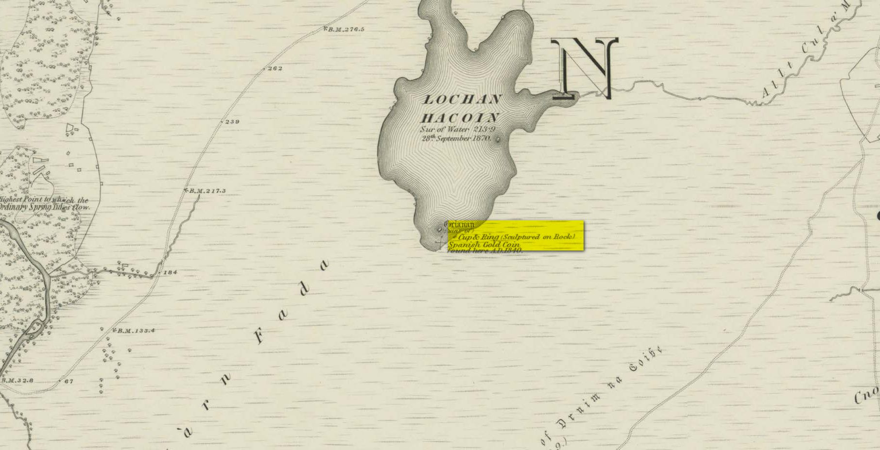
Whether you take the A836 or A838 into Tongue (through truly beautiful wilderness), make sure you go into the village itself—and then keep going, south, along the tiny country road. Nearly 2½ miles along, note the small loch of Lochan na Cuilce on your right. A few hundred yards past this, on the other side of the road (barely visible at first) is Lochan Hakel. Walk around to the south-side of the loch until you find the Lochan Hakel 1 carving. Then look up at the rock right above you. That’s the one!
Archaeology & History
In James Simpson’s (1867) primary work on British petroglyphs, he mentions this site as being in the lands of “Ribigill, near Tongue”, although it is a little further to the south. He said that a certain “Mr Mitchell” had come across it in one of his many rambles in the hills (this was probably Arthur Mitchell, author of the 1880 book, The Past in the Present). Simpson told that he had:
“discovered cups and circles upon a large stone, about nine feet square, apparently lying in its original position, close to the edge of a loch, which contains the remains of an old castle… The surface of the stone shows eighteen or twenty round cup excavations, about an inch deep. There is a ring of ‘hollow around each cup.'”
Although there aren’t rings around every cup, a great number of clear and impressive rings exist around many of them and are, thankfully, still reasonably visible amidst the mass of lichens.
Around the same time as Mr Simpson’s description, James Horsburgh (1868) wrote about the carving, telling us:
The rock and its islandSome of the cup-and-rings
“On the edge of the precipitous bank of the loch, and exactly opposite the island, there is a large boulder with a flat top, and on this there are a number of cups and rings… This stone is not generally known. Old Ross, the gamekeeper at Tongue, first told me of it, and he and I scraped off the moss and exposed the whole. He thought it was for playing some game. On the left of the stone, on a bit separated by a crack, there is a sort of a figure which appears to have been formed by cutting away the stone around it and leaving it in relief, and also some artificial cutting on the right, a sort of circular groove.”
A better description of the carving came near the beginning of the 20th century, when the Scottish Royal Commission (1911) lads included the site in their inventory. They told:
From the rock, looking NThe carving from above
“At the S end of Lochan Hacoin, to the SE of the islet on the top of the bank, is a large earth-fast boulder, on the flat upper surface of which are a number of cup and ring marks placed irregularly over it. The total number of undoubted markings is thirty-four, of which those surrounded by a ring number eleven. No cup with a double ring round it is observable. The best defined cup-mark measures 3″ across by 1¼” deep, and the enclosing ring is 7″ in diameter. Eight of the markings are well defined; the others less noticeable. At the S end there is a boss or projection, roughly rectangular, measuring 12″ x 6″. A sketch of this stone, made about the year 1866 by Mr James Horsburgh, is preserved in the library of the Society of Antiquaries of Scotland.”
Does anyone know if this drawing still exists? Anyhow, whilst you’re stood here looking at this petroglyph, don’t forget to look at the other one on the rock below you closer to the loch-side.
Folklore
In Horsburgh’s essay on the prehistoric remains of the area, he said how local people told that the cup-and-rings “were made by the high heels of a fairy who lived in the castle” on the island of Grianan, just 40 or 50 yards away.
References:
Close-Brooks, Joanna, Exploring Scotland’s Heritage: The Highlands, HMSO: Edinburgh 1995.
o’ Reilly, Kevin, What to See Around the Kyle of Tongue, privately printed 1980.
Royal Commission on Ancient & Historical Monuments & Constructions of Scotland, Inventory of Monuments and Constructions in the County of Sutherland., HMSO: Edinburgh 1911.
Simpson, James, Archaic Sculpturings of Cups, Circles, etc., Upon Stones and Rocks in Scotland, England and other Countries, Edmonston & Douglas: Edinburgh 1867.
Acknowledgments: Huge thanks to Sarah MacLean for guiding me to this carving, and also for the kind use of her photos in this site profile. Cheers Sarah! And to Donna Murray again, for putting up with me whilst in the area! Also – Huge thanks for use of the 1st edition OS-map in this site profile, Reproduced with the kind permission of the National Library of Scotland.
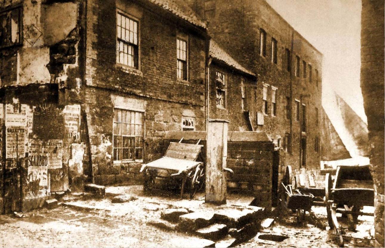
Holy Well (destroyed): OS Grid Reference – NZ 9006 1102
Archaeology & History
Virgin’s Pump, c.1890
This is one of at least five wells dedicated to St. Hilda in North Yorkshire that my old colleague Graeme Chappell has uncovered over his many years of research. It’s sadly been destroyed, and accounts of it seem to be few and far between; but from the short description of it by Mr J.C. Atkinson (1894)—and helped out by its later title—we at least know where it once was.
In his account of the old roads in the village, Grape Lane was mentioned as far back as 1396, and close by, he wrote,
“is a spring called Seynt-Hild-keld, possibly where the so-called “Virgin pump” stands, or stood, not so very long since.”
This ‘ere “virgin pump” is shown in an old photo taken about 1890, just round the corner from Grape Lane where, today, is the car park on Church Street, opposite The Endeavour.
Folklore
St Hilda was a 7th century saint who was reputed to have founded Whitby Abbey. Her festival date was November 17.
References:
Atkinson, J.C., Memorials of Old Whitby, MacMillan: London 1894.