Pretty easy to find – assuming it aint at the height of summer and the crops are approaching maturity, otherwise you’re only gonna see its head! But, this aside: from Aberfeldy, take the B846 road over the river bridge that bends you along the valley of the River Tay towards Appin of Dull. After some 2 miles you’ll pass the right-turn up to Dull. Go past this for another coupla hundred yards or so, watching out for the left-turn down towards the farmhouse of Carse and park up where you can (if you go past it, there’s the second turn up to Dull, again on your right, where you can turn round). As you walk down the track towards Carse Farm, watch out on your right in the field below Carse I, in the second field down. You can’t really miss it. (and the farmer here is spot on if you ask to check the stone – as long as the crops aint growing)
Archaeology & History
Although all that’s left of what is thought to have been a once proud stone circle is the singular upright standing stone in the middle of the field. Aubrey Burl (1988) thought that this was one of the typical “four poster”rings that scatter our isles, but I’m not so sure misself. There were other stones associated with the site when Burl described it, but these were covered over in our visit here a few months back — which is a pity, as two of the stones are reported as possessing cup-markings (if/when we revisit the site, I’ll try get some images of the respective stones and add them on TNA as individual carved stones). The site gives the distinct impression of it having a funerary character of some sort and not a true stone circle — and this was strongly suggested by some of the finds inside the “ring”, described below.
Fred Cole’s old drawingAubrey Burl’s groundplan
Both this and its associated “circle” a few hundred yards away — known as Carse Farm north — sit on a flat level of ground in the Tay valley, with rounded hills all most sides. This landscape setting was obviously of some importance to the people who put the circle here in the first place but, not living in the region, it’s difficult to assess the mythic relevance some of the hills will have obviously played in the siting of these stones.
In bygone days, it was reported that the much of the site was ploughed away due to agricultural excesses, so there was obviously much more to it in earlier centuries. Describing the solitary stone that’s left today, along with the earlier excavation results, Mr Burl (1988) wrote:
“The stone still standing, of quartziferous schist, is 6ft 3in (1.9m) high. Its longer faces are aligned NW-SE. 32ft 6in (9.9m) to its SW is a large prostate block, sub-elliptical and about 8ft long and 4ft 3in wide (2.4 x 1.3m). It has probably fallen outwards. (my italics, PB) If so, when standing near the top of its inner face were four cupmarks in a cross pattern.
“About 32ft ((9.8m) to its NW is a fallen and enormous schist slab, 11ft long and 5ft wide (3.4 x 1.5m). It also appears to have toppled outwards. Near the bottom of its inner face are two cupmarks. The situation of these three stones suggests that they once stood at the corners of a rectangle some 32ft (9.8m) square, the pillars of a huge four-poster nearly six-times the national average and with an internal area ten times bigger than the small 4-poster (Carse Farm north, PB) just to its north.
“Excavation in 1964 found the socket from which the great prostrate slab had been dragged… Cash (1911) had noted the presence of a small stone inside the ring about 20ft (6.1m) west of the standing stone. It proved to be 4ft (1.2m) square with a carefull-dressed face. It had been set upright, standing about 1ft 4in (41cm) above the ground. Three sides of the worked face ‘had been carefully chiselled away to a straight edge.’ It may have been a slab lining the inner central space of a destroyed ring-cairn. Burnt bone was found near it. There was also a rounded river pebble with a worked hollow on one side…”
Folklore
Carse Farm stone
Stewart (1964) described the site as having been “christianized” not long ago, by having the northernmost standing stone in the ring removed. This is intriguing inasmuch as “north” is the place of greatest symbolic darkness in the pre-christian mythos, and represented death and illumination in magickal terms. North was also the point taken by witches and shamans in their excursions into Underworlds, usually via the North Star, which tethered the Earth to the heavens (see Godwin’s Arktos [1993], and Grant, The Magical Revival [1973]) In the removal of this northern stone for the reasons given, that implies some magickal events or folklore were in evidence here when this took place. Anyone got any further information along these lines, or has it long since been subsumed?
References:
Burl, Aubrey, Four Posters: Bronze Age Stone Circles of Western Europe, BAR 195: Oxford 1988.
Tumulus (destroyed): OS Grid Reference – SE 426 634
Also Known as:
Deuill Cross Hill
Devil’s Cross
Urn from Devil’s Cross tumulus
Archaeology & History
In Henry Smith’s wonderful Reliquiae (1852) on the history of Aldborough and district, this intriguingly named but forgotten site is given the greatest literary attention extant. Assumed by a couple of modern academics – without evidence – to have been little more than a natural hillock, this once great mound was undoubtedly an important burial place for some ancestral characters. Although its exact location is unknown (anyone out there know for certain?), it was said to have been located about 100 yards from where the old tracks crossed at Duel Cross.
First described by a Mr Urban in the Gentleman’s Magazine of June, 1787. He told it to be known as the Devil’s Cross and was a tumulus,
“whose elevation is about 18 feet, and circumference at the base 370 feet. It was broken into some time since to supply materials for the repair of the high road leading from Aldborough to York. The soil consists, first, of a black earth, and under that a red sandy gravel, human bones, some of which are entire, and urns of various sizes. The urns are composed of blue clay and sand, some ornamented and others quite plain; several Roman coins have also been found here.”
There were a great number of old urns found in the mound when it was dug into in 1756, leading Mr Urban to believe the site was used an ancient cemetery. Intriguingly he told that all of the urns and their ashes were found to have been placed on one side of the mound, with many human bones being deposited in another section, away from the urns. This, the finding of Roman coins next to the mound and the proximity of the Roman road led Mr Urban to believe the site was a Roman tumulus, though this seems unlikely. Years later, Henry Smith’s (1852) commentary on the Devil’s Cross hill led him to believe the mound was from a much earlier period:
“From a sketch of one of these, which is stated to have been nine inches high, there can be little doubt of these cinerary urns bring of the ancient British period, but from the great number of bones discovered, this tumulus was probably used as a cemetery during the Romano-British period, if not still later. Of its use in Roman times, evidence is unequivocally supplied in the numerous coins found here…”
Carved stone figure (from Smith’s ‘Reliquiae’)
Not far from this long lost tumulus, a curious carved stone figure was located “among ancient foundations” in a cellar! Thought to be a local deity, it may have been a carved representation of whichever figure or spirit ancestor was buried in Duel Cross Hill — though we’ll never know for sure.
Folklore
Although archaeologically, etymologically and geomantically related to the nearby Devil’s Arrows at Boroughbridge a couple of miles up the road, there is nothing specific I can find of this once important tumulus. However the place-name in both forms, Deul and Deuill, refers to the pre-christian devil (from deofol, Old English, “devil”). This name may relate to the stone figure shown in the illustration, or of long lost heathen rites enacted here in bygone times. Any further info on this place is very welcome.
References:
Hargrove, E., The History of the Castle, Town and Forest of Knaresbrough, Hargrove & Sons: Knaresbrough 1809.
Smith, Henry E., Reliquiae Isurianae, J.R. Smith: London 1852.
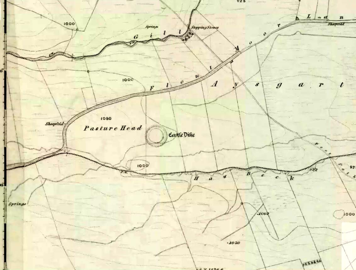
Go west through Aysgarth village along the A684 road and, just as you’re coming out of the town, take the left turn on the Thornton Rust road, past Town Head Farm, and turn left up the track (called Folly Lane). Go past the house where the track veers to your right and follow it straight on (don’t turn up the track on your left a short distance along). Keep walking on here for nearly a mile (about 10 mins), keeping your eyes peeled for the embanked rise in the field on your left, which is where the henge can be found! You’re damn close!
Archaeology & History
A.H. Allcroft’s 1908 plan
One of the earliest accounts I’ve found describing the Castle Dykes henge is in Mr Barker’s (1854) lovely literary exploration of Wensleydale, where he describes, “on Aysgarth Moor, which is now enclosed, may be seen a circular encampment, probably Danish” in origin. But he tells no more. When Edmund Bogg (c.1906) came here fifty years later, he added little extra, simply telling of, “the earthworks known as ‘Castle Dykes’, probably Angle or Danish, although Roman relics have been found here.” However, the brilliant Mr Speight (1897) gave what seems to be the earliest real description of the site when he described “the Celts” and the earliest settlers of the region, saying how:
“The so-called ‘Castle Dykes’ at Aysgarth betrays a probable connection with the same settlers. It is an irregular circular rampart, measuring about forty yards across its longest diameter, and not unlike the earthwork on Harkaside called ‘Maiden Castle’… A ditch completely encloses the mound, which, it should be noted, is unusually low, being little higher than the outer bank or upcast from the trench. It is totally different from the elaborate burh at Middleham; indeed, from its low and simply form, as well as from its situation in Celtic territory, there seems little doubt that it was the work of these early people.”
Ditch of Castle Dykes henge, looking east (photo credit – Richard Stroud)
Speight also made a suggestion that the place-name of Aysgarth itself may derive from this monument. He may have a point. A.H. Smith (1928) and other place-name authorities tell the name to derive from “an open space” either surrounded by, or — in some way — defined by oak trees. We might never know for sure…
Not long after the works of Speight and Bogg came the first real survey of British prehistoric earthworks by A.H. Allcroft (1908) — and amidst the mass of archaeological curiosities (as many were at the time) was another description of this great ceremonial monument. Allcroft told that here,
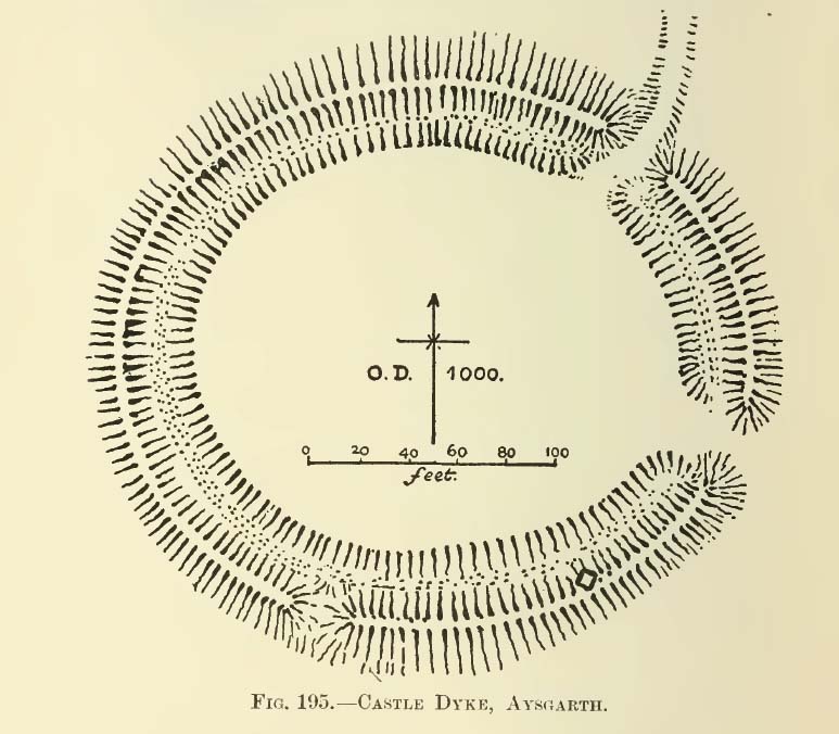
“a weak vallum of earth encloses a perfectly regular oval area measuring from crest to crest of the vallum 257 feet (east to west) by 217 feet (north to south). Immediately within the vallum is a broad fosse varying from 25 to 32 feet in width. The vallum at its highest (east) rises not more than seven feet above the floor of the fosse. The “island” measures 196 by 160 feet and is perfectly flat. There is no berm and no outer fosse. The vallum is broken by three gaps, of which that to the southeast is apparently original, as the fosse has never been excavated across it. The other gaps point respectively northeast and south-southwest, the latter being a mere depression like that to be seen at the eastern side of the northern ring at Thornborough. At one point in the vallum, on the southeast, a single large stone rises slightly above the turf which otherwise covers the whole work, and certain depressions observable at other points suggest that other such blocks have been removed —that, in fact, it originally had a peristalith standing upon the vallum. The principal entrance looks towards Pen Hill…”
Around the same time, the early scientific discipline of astroarchaeology was taking root and in Sir Norman Lockyer’s Nature journal, the reverend J. Griffith (1908) explored the potential astronomical orientation of Aysgarth’s Castle Dykes, thinking that the main entrance to the site gave indications of an alignment towards either Alpha Centauri or Capella. Y’ never know…
Although many visitors and local people knew of Castle Dykes, it was pretty late before the site gained status as a henge monument. This happened following a visit here by the pedantic archaeologist R.J.C. Atkinson (1951) in September of 1948. Following his visit, Atkinson described the place, saying:
“It consists of an oval enclosure bounded by a well-preserved ditch and external bank, with an entrance on the East side. Two small gaps in the bank, without corresponding causeways across the ditch, were probably made in recent times to allow the escape downhill of the surface water which collects in the ditch. The dimensions in H. Allcroft’s plan are incorrect. The markedly oval shape is probably in part dictated by the situation, in order that as much as possible of the enclosed area should lie on the level ground topping the ridge. There is no sign of any stone structure in the central area, but the district abounds in stone walls, for which the site may have been robbed in the past.”
Aerial image
In more recent years, archaeologists have speculated that the site was a sacred site or meeting place, aswell as a site where trade occurred, particularly a place where axes were traded; but this latter idea is more due to the projection of a modern religious notion, of ‘The Market’ with little veracity in terms of the site’s function. This increasing imposition of ‘economics’ and ‘trade’ (see Brown 2008:44-6) as vital ingredients to this and other sites has little relevance outside of a simple epiphenomenalistic adjunct to magical and tribal exchanges. But such notions are outside of archaeological frameworks, so we shouldn’t be surprised at so prevalent an error.
But this place is damn impressive — though with the exception of Mr Griffith, one notable ingredient archaeologists seem to have forgotten about was the position of this site in the landscape. The views surrounding the henge are excellent, giving a 360° arena all round. If the monument once had a ring of stones around it, as Allcroft suggested, the views would still have been the same. A modern excavation here might prove worthwhile and, as a result, open up once again, the potential for further astronomical investigations with the many hills and notches along the living horizon. This site, whilst requiring analysis of it as a ‘specimen’, must also be placed in the context of the wider living environment which, to all early traditional cultures, were such important and integral ingredients.
We have also found some previously unrecorded prehistoric remains nearby which, hopefully, we’ll be able to explore a little more in 2011 and report here.
…to be continued…
References:
Allcroft, A. Hadrian, Earthwork of England, MacMillan: London 1908.
Atkinson, R.J.C., “The Henge Monuments of Great Britain,” in Atkinson, Piggott & Sandars’ Excavations at Dorchester, Oxon (Department of Antiquities: Oxford 1951).
Barker, W.G.M.J., The Three Days of Wensleydale, Charles Dolman: London 1854.
Bogg, Edmund, Wensleydale and the Lower Vale of Yore, E. Bogg: Leeds (c.1906).
Brown, Paul & Barbara, Prehistoric Rock Art in the Northern Dales, Tempus: Stroud 2008.
Griffith, Rev. J., “English Earthworks and their Orientation,” in Nature, volume 80, 18 March 1909.
Harding, A.F., Henge Monuments and Related Sites of Great Britain, BAR 175: Oxford 1987.
Smith, A.H., The Place-Names of the North Riding of Yorkshire,Cambridge University Press 1928.
Speight, Harry, Romantic Richmondshire, Elliot Stock: London 1897.
Acknowledgements: Many thanks to Richard Stroud for use of his photo of the henge.
Destroyed by the usual mixture of intensive farming practices and the self-righteous advance of industrialism, this cursus of many names was discovered thanks to aerial survey photographs taken in the early 1960s. Found only 6½ miles west of the Aston Cursus and constructed on level ground on the north side of the River Trent next to B5009 road between Twyford village and Willington. I think the site was first described by J.K. St. Joseph (1966) in his notes on air reconnaissance finds, in which he described the site,
“So far the parallel ditches, some 220ft apart, defining the cursus have been identified on an east to west alignment across three fields for a length of some 1800ft. This may well be only fraction of the total length of the monument, which probably extended westwards towards the new power station at Willington. Three ring-ditches, one lying within the cursus, and two to the north, as well as a rectangular enclosure, have also been recorded.”
There was probably more to be discovered here, he thought. And so the following year the first dig into one section of the site was made, and again in 1969. A synopsis of this and subsequent excavation work have been reported on the PastScape website which tells:
“The cursus has been traced for a distance of at least 1560 metres, lying near the edge of the flood-plain of the Trent. Excavations in 1994-5 in advance of work on a bypass recovered Peterborough Ware sherds close to the bottom of the southern cursus ditch. Charred organic remains were also present, from which radiocarbon dates are to be sought. The excavations also uncovered a causeway between 10.5 and 19 metres in length through the northern ditch. Within this causeway were a cluster of short linear features and a post hole, all presumably evidence for controlling access into the monument. Another break in the northern ditch was shown to have been created to accommodate the course of a stream, which still runs through it. The 1994-5 excavations also confirmed that the 1969 excavations had in fact found a series of natural features which were mistakenly interpreted as representing the cursus ditches… At the south-western limit of the cursus cropmarks the southern ditch appears to have been recut and possibly reused at a later stage as a double ditched trackway…”
References:
St. Joseph, J.K., “Air Reconnaissance: Recent Result, 6,” in Antiquity journal, volume 40, no.157, March 1966.
Wheeler, Hazel, “The Findern Cursus,” in Derbyshire Archaeological Journal, volume 90, 1970.
An unusual cup-marked stone — not because it’s found in the grounds of the chapel, but because the design appears carved on a flat slab, as if it might have been used as a grave cover or perhaps stood upright in times gone by. First described in Rob Graham’s Carved Stones (1895) in the days when a few more cup-markings were visible; nearly a hundred years on it was included in the Royal Commission’s (1984) report as “a prone slab measuring 1.7m by 0.98m and 0.15m in greatest thickness; its upper surface bears at least nineteen plain cups up to 110cm in diameter and 40mm in depth. In addition, wear has caused a large deep cup, 180mm in diameter and 80mm deep, to penetrate the stone, and there is another circular, vertical-sided, perforation measuring 70mm in average diameter and expanding to 90mm at the upper surface on the stone” — meaning there’s a hole that’s been worn through the rock itself. This hole would seem to be accounted for by the folklore tradition of the site.
Folklore
It was reported by R.W.B. Morris (1969) that the cups here were “said to have been enlarged by a former ‘wishing’ rite” — a tradition echoed at another carving not far away where a pestle was used on the cup-marks and rotated 3 times, then a wish was made and an offering left to aid the wish. Morris suggests this could have been a faint relic of solar worship.
References:
Graham, Robert C., The Carved Stones of Islay, James Maclehose & Son: Glasgow 1895.
Cup-Marked Stone: OS Grid Reference – SO 1576 5858
Also Known as:
Llanerch Stone
NPRN – 306082
Archaeology & History
Llanerch cup-marked stone (after Watkins, 1932)
A small and simple cup-marked boulder, hidden away in the Welsh hills, all-but unknown even to cup-and-ring fanatics! It’s nowt special to look at, reminding me somewhat of the numerous cup-marked rocks that scatter the edges of Baildon Hill in Yorkshire. Found close to a number of other prehistoric sites, the stone isn’t in its original position so we’re unable to tell whether it was associated with any tombs (as is probable). The carving consists of around 32 cup-marks, with some 18 of them visible on its upper face. It’s likely that there were more cups on it originally, for when it was first found (as shown in the photo here, taken soon after being discovered) one side of the stone had been split away, but the other section was nowhere to be seen. Alfred Watkins (1932) told how it was first discovered:
“Following a visit by the Woolhope Club in 1928 to that fine mound on Radnor Forest—Cruger Castle…a fellow member (Mr. Walter Pritchard), working on alignments, discovered a fine cup-marked stone, at Llanerch Farm, a little south of the mound. I visited and photographed the stone the same year, and took a rubbing of the cup-marks on it, also taking as careful a bearing as possible, and marking it on the paper while on the stone.”
Its isolation is a little unusual, but there are likely to be other carvings scattering the nearby hills and valleys awaiting discovery by enthusiastic explorers.
Folklore
The great ley-hunter himself, Alfred Watkins (1932) — following in the footsteps of some of his contemporaries it’s gotta be said — used this carving to add fuel to his notion of leys and aligned sites, thinking that the cup-markings on the stone were representative of such things, etched thousands of years back to be used by other travellers. Can’t see it misself — but then I did spend a few years looking at the potential relevance cup-and-rings had with alignment features when I was a boy, ruining many a-map and finding they had no relationship whatsoever to such things! But it seems that Mr Watkins was still going through the exploratory phase at the time, because, after taking a rubbing of the stone he told:
“I also (as soon as I got home) tested for alignments, and inked in those of four cups which I found, as I considered lines of three to be of no value as proof. I could not at that time see any tangible proof of anything, and put it down to this (broken) stone having probably been moved. The reproduction I give is of this crude rubbing exactly as I finished it (outlining then the rather indefinite edges of the cups) in 1928.”
References:
Sharkey, John, The Meeting of the Tracks: Rock Art in Ancient Wales, Gwasg Carreg Gwalch: Llanrwst 2004.
Watkins, Alfred, Archaic Tracks round Cambridge, Simpkin Marshall: London 1932.
Running roughly north-to-south, this cursus was 2¼ miles long (3600 metres) and comprised of two linear sections from a field in Stanwell up through the western side of Heathrow Airport averaging, curiously, just 24 yards (22m) across. Of course nothing of it can be seen today as the airport and surrounding industrial crap has destroyed it. The cursus had a lengthy internal bank along its length. During excavation work done at the Perry Oaks Sludge Works section in Hillingdon, archaeologists found evidence for a short avenue of posts, about 110 feet long, apparently constructed prior to the cutting of the cursus’ ditches, following the same direction/alignment of the subsequent monument. In Roy Loveday’s (2006) survey of cursus monuments he said this of Heathrow’s cursus:
“This site, striking across land so flat that it has been selected for Heathrow Airport, extends for some 4km, crosses two rivers and stops by a stream — originally perhaps a more major river. So straight and apparently narrow is it (20m) that it was originally taken to be a Roman road. Early excavation seemed to support the idea: vestigal remains areas of gravel between the ditches were scored by shallow gullies resembling cart ruts. Later excavation, however, demonstrated that the ditches of a Late Bronze Age field system cut across it and several scarps of Peterborough Ware (i.e., pottery – PB) were recovered from its ditches. Evidence also emerged of a short (50m) ragged, double row of posts, removed before the ditches were dug on the same alignment. That this was a bank barrow was hinted at by the Charlecote test and by reduction in the depth of field ditches as they crossed the central area.”
Confirmation that an earthen bank of some kind running near the middle of the cursus was confirmed by analysis of early Ministry of Defence aerial photographs. For those who would like a more detailed description on this site, I refer you to the excellent paper by o’ Connell. (1990)
…to be continued…
References:
Barclay, Alistair, et al, Lines in the Landscape, Oxford Archaeological Unit 2003.
Loveday, Roy, Inscribed Across the Landscape, Tempus: Stroud 2006.
o’ Connell, M., “The Heathrow-Stanwell Cursus,” in Current Archaeology, 9, 1986.
o’ Connell, M., “Excavations during 1979-1985 of a Multi-Period Site at Stanwell,” in Surrey Archaeological Collections, 80, 1990.
This once-impressive Bronze Age tomb is now much denuded and stands besides the legendary Fleam Dyke. The name of Mutlow was first used to describe this site in the 1812 Enclosure Act and means, literally, an “Assembly Hill” or Assembly burial mound. Reaney (1943) told that it was situated “at the junction of the boundaries of Great Wilbraham (Staine Hundred), West Wratting and Balsham (Radfield Hundred) and Fulbourn (Flendish Hundred)”, and was obviously an important moot spot where local tribal and council laws were made.
The great Cambridge archaeologist, Tom Lethbridge (1957) briefly described the place in his fascinating survey of the nearby hill-figures, Gog and Magog, saying:
“The hill itself is a Bronze Age barrow which was dug by the Hon. R.C. Neville about a hundred years ago. In it were, amongst other things, glass beads brought to Britain from the eastern Mediterranean in the fifteenth century before the birth of Christ. The barrow, which was presumably the site of a moot in Saxon times, seem to have been used as a sighting point for the construction of the Fleam Dyke… A circular Roman building, either a temple, or possible a signal station, stood close to Mutlow Hill.”
Lethbridge pointed out that another lesser-known trackway — “known in Saxon times as ‘the Street'” — also passed here, saying:
“When the land is ploughed and the light is right, you can see the numerous dark lines on the soil, all converging on Mutlow Hill. These are the old hollow ways of the Icknield Way and the Street.”
Folklore
One legend here speaks of a golden chariot that is reputedly buried either inside, or near to the old tumulus. Lethbridge (1957) again told of hearing this tale, though narrated, “it was said to be buried in Fleam Dyke near Mutlow Hill.” When he asked a local lady about the tale,
“She replied that she had always heard that it was not in the dyke itself, but in the road which passed the dyke and went on to West Wratting and the southeast.”
References:
Lethbridge, T.C., GogMagog: The Buried Gods, RKP: London 1957.
Reaney, P.N., The Place-Names of Cambridgeshire and Isle of Ely, Cambridge University Press 1943.
From Hebden Bridge, take the Heptonstall road and go past the legendary Slack Bottom (no lies!), until a few hundred yards further on at Slack Top, take the Widdop road on the right. Amble the long and winding road for a mile – mebbe a bit more – until the valley on your right runs out of trees! (on the OS-map this is called Hebden Dale, but it’s generally known as Hardcastle Crags [after the name of the rock outcrop halfway up]). Just about here there’s a track to your left, by the rather desolate bus-stop! If you hit the wibbly hair-pin bend by the Blake Dean scout-hut, you’ve gone too far. Walk along the track for a coupla hundred yards and take the first opportunity you have to cross the deep dike on your immediate left. Then just walk along the edge of the stream itself until you reach the large rocks another few hundred yards along.
Archaeology & History
As Richard Stroud’s photo above shows, this is a beautiful spot — when the weather is good anyway! Much of the landscape around you is scattered with occult history and folklore: boggarts, witches, corpse routes, spirit animals, old stone crosses, standing stones and more! A damn good day out can be had in this area by any enthusiastic antiquarian or enquiring heathen.
Cups and faint rings
The carving we have here is an almost typical cup-and-ring stone, but it’s pretty isolated with no other ringed companions anywhere on these hills. It was first described in David Shepherd’s (2003) survey of prehistoric remains of the region — although I was initially a little cautious about the veracity of David’s findings, as some cup-marked stones in his survey are probably natural and some “standing stones” he cites nearby are simply natural earthfast rocks. But this particular carving seems man-made with large faint rings encircling at least one of the cup-marks, as you can see in Richard Stroud’s photo here. In Mr Shepherd’s survey, he said of this site:
“A prominent double boulder. On the top surface are two eroded cup marks by the south edge and one by the north edge. Two eroded cup marks with rings are on the northwest segment.”
References:
Shepherd, David, “Prehistoric Activity in the Central South Pennines,” in Transactions of the Halifax Antiquarian Society, new series, volume 11, 2003.
Acknowledgements: With thanks to Richard Stroud for use of his photos in this site profile.
Aerial image showing faint outline of Blackheath circle
From Todmorden, take the road to Hebden Bridge (A646) less than half-mile outta town and just as road goes uphill, watch for the left turn up to Cross Stone. This is one helluva superb steep, winding road if you aint been up it before (which, somehow, I used to be able to cycle up without a break!). As you reach the hamlet of Cross Stone, bear uphill again (left) until you reach the top-end of the golf course, where you’ll see a footpath on your left that runs alongside the course. Walk on this until it reaches a stile. Walk up the wallside and onto the course itself – and there, in front of you, in the middle of the damn golf course, you’ll see the very denuded remains of a once fine prehistoric monument (it’s situation, quite frankly, is a disgrace – and any pagans or historians who feel similarly should complain to Calderdale Council about the lack of preservation here; as the more of us who do, the more they’ll have to pay attention and perhaps do something about it).
Archaeology & History
Very little can be seen of this once important site thanks to the important golf course built right on top of this once sacred site. Thankfully we have an extensive description of the place that was done by J. Lawson Russell (1906) from which this profile account — and every other account for that matter! — draws heavily upon. It was included in Aubrey Burl’s magnum opus (2000) as a stone circle, but this isn’t strictly correct and is more accurately a cairn circle or ring cairn monument.
Blackheath Circle’s shallow semicircular bankBlackheath circle, looking SE
It was thought in times past to have been a monument built by the Romans (hence the earlier title of ‘Roman Barrow’), but its origins were much earlier than those scruffy incomers! Its other local folk name, the “Frying Pan Circle” is, like its namesake at Morley, an etymological curiosity relating to the flat ground left in the wake of its shape: flat, circular, with raised edges surrounding it, not unlike a frying pan.
It was accurately described for the first time by Robert Law (1897), who later broadened his account of the site a year later in a paper he wrote for the Yorkshire Geological Society (1899) after an excavation here. Mr Law and others explored the centre of the ring where they believed it most probable to find remains of some form or another — and they weren’t to be disappointed! The following is taken directly from his lengthy article:
“On Thursday, July 7th of this year (1898), a very interesting and important archaeological discovery was made on a portion of land known as Higher Cross Stone Farm, belonging to Mr. Sutcliffe, of Todmorden. In a field on this farm, called Black Heath, a ring circle, made of earth, has long been known to exist, and has gone by the name of the “Frying Pan.” No history or tradition exists as to the origin of this circle, and various speculations have from time to time been indulged in by the residents. Some have called it a Roman Camp, others a fairy circle, others a circus ring, made to break in horses; but the excavations prove it to be a burial place of prehistoric times. Mr. Tattersall Wilkinson, of Burnley, a well-known archaeologist of considerable experience on ring circles, along with the writer of this article, came to the conclusion, on hearing of this circle, that it probably contained human remains, and an excavating party was organised to meet on the spot on the day above mentioned. This party met at the appointed time, and the plan of operations was to find the centre of the circle, by means of a tape, then to dig a circular trench about three feet from the centre, in which space it was thought the remains would lie. The ring was nearly a perfect circle. It was raised conspicuously above the ground. The rim of raised earth was about three feet wide, and the diameter of the whole circle was thirty yards. After the digging had been going on for a short time, burnt soil and charcoal were met with, and the top of an urn was exposed to view. The diggers then went to work with the greatest possible care, and very soon a beautiful urn was laid bare exactly in the centre of the ring. The urn was embedded in charcoal and calcined bones. It was ten inches high and nine inches at the top, tapering to about three inches wide at the bottom. There was a rim or collar in the upper part of the um about three inches deep, which stood out about one inch in relief from the lower part of it. The collar was ornamented, probably by a pointed stick, with the herring-bone pattern. The outer part of the um was plain. In clearing away the debris from the urn another one was discovered, different in pattern and less in size, but in a very perfect state of preservation.
“About two feet from this, on the opposite side of the central urn, another um was discovered and laid bare, by carefully digging round it with a trowel. This urn was also in a good state of preservation, and about the size of the second one, but differently ornamented. These smaller urns were the same shape as the larger central one, but the ornamentations were not so fine, and they were made of inferior clay. On the south side of the circle, about two feet from the centre, another urn was discovered, but it appeared to be insufficiently baked when manufactured, and had decomposed and crumbled into dust. From the inside of this urn a large quantity of calcined human bones and charcoal was dug up, but the bones were very fragmentary, and the sex of the person to whom the bones belonged could not be determined. Several portions of cranium, rib bones, and lower and upper leg bones were found among the debris.
“Within a few inches of this urn two small (so called) incense cups were found. One of them was very perfect and in an excellent state of preservation and was beautifully ornamented all over. These cups were about three inches in height and three and a half inches in diameter, but tapered a little at the bottom. Indications of three other urns were observed, but they were so much decomposed that little or nothing could be made of them. The others seemed to be arranged about the large central urn and about two feet apart. When the earth had been cleared away from the three perfect urns, and before they had been removed, several photographs were taken of them in situ. One of the smaller urns leaned a little to the south. Several pieces of flint and chert were dug out of the excavation. The urns and incense cups being removed were put into baskets and conveyed to Todmorden, where they were re-photographed and placed in the Free Library for their safe keeping.
“On July 13th, six days after the “find,” the urns were opened at the Co-operative Hall, Todmorden, before a very large gathering of scientific ladies and gentlemen drawn from the surrounding districts. Mr Tattersall Wilkinson, Dr. Crump of Burnley, and the author were entrusted with the opening of the urns.
“The largest one, which was of superior make to the other, was the first to be operated upon. The work was tedious and was done in the most careful way possible. Each operator commenced to pick out by means of a small pocket knife the substances deposited in the urns, and the material was closely examined as it fell out on the table. For the first half-hour or so nothing particular was found. The contents which had been so far dug out were portions of broken urns of a similar pattern to the urn that was being examined, but were not portions of it and must have been placed there as filling-in material. Along with these urn fragments there was some dark brown sand, which appeared to have been burnt, quantities of bituminous soil, small fragments of bones, and bits of charcoal. As the examining party dug deeper into the urn human bones became more numerous and in larger fragments and of a more determinable character, and this went on until the urn had been half emptied. The rest of the contents of the urn then showed signs of being almost entirely calcined bones, and bone after bone was picked out, examined, and laid on the table. Among these bones were fragments of various sizes: of cranium, portions of scapula, pelvic bones, femur, tibia and other bones of the legs. Besides these there were fragments of ribs and perfect toe bones.
“Presently a small cup was laid bare inside the urn, and a few pokes with the knife so far emptied it of its contents that an ancient relic could be seen which differed from any that had yet been found. A moment later a piece of metal was picked out of the cup resembling a spear head. It was about 2½ inches long and 1¼ inches wide at one end, and tapered to a point at the other. It was thin and flat and sharp at the sides and point. It contained a rivet at the two extremities and another one about half way up one side. A bronze pin was also found about the same time as this piece of metal, and on careful examination the metal and the pin were made out to be a bronze brooch, the pin having probably been detached in extracting it from the bones in the cup. Besides this brooch about a dozen beads of a necklace were found, which were chiefly of a rounded shape and about half an inch in diameter. Some of the beads seem to have been made of jet, and some of bone, and were more or less rudely carved. A bone pin was next brought to light. It was almost two inches in length and the eighth of an inch in diameter at one end, tapering towards a point at the other. It was cylindrical in form and slightly curved. The fact of all these ornaments having been carefully placed in the cup and buried with the urn point to the cup having been used as a utensil in which to preserve what was considered of great value. Several human teeth were also found in this cup.
“The opening of the two inferior urns proved that they contained nothing more than the sweepings up of the funeral pile which probably took place after the calcined bones had been placed in the more important urn.
“Since this discovery was made a beautifully-formed flint arrowhead of the leaf-shaped pattern has been found in the same hole from which the urns were dug. There have also been two or three more urns discovered within the same circle, but their contents have not yet been disclosed.”
Early 1899 photo of the Blackheath urnsBlackheath urns on display, c.1911
They had to wait a few more years before a more complete account described the contents of the “two or three more urns” at Blackheath’s circle. That duty fell to Mr J. Lawson Russell (1906), who, after further excavations, wrote the most detailed and complete account of the place.
Following the successful discoveries in 1898, Messrs. Russell, Law, Wilkinson and others made a “further systematic examination of the whole circle”, which was then subsequently wrote up in Ling Roth’s Prehistoric Halifax. The following is a detailed account of that second dig:
“The first step in the systematic examination was the breaking up of the circle into quadrants. This we did by running deep trenches north, east, south and west. The turf was then removed and these quadrants dealt with seriatim. The diameter of the circle was as nearly as possible 100ft (30.5m), i.e. measuring from ridge to ridge, but the slight mound which marked the circumference sloped gently further into the general level of the field. Eight or nine deep furrows ran through the circle, from north to south, cutting the vallum up into segments and ploughing the enclosed area with their parallels. The method we followed was to trench till we came to soil which had never been disturbed. Generally about two spade grafts brought us to stiff glacial (?) clay. When we came upon an urn its position was carefully observed with reference to the centre and noted on a plan ; the earth was removed by trenching round the um, which was photographed in situ when sufficiently defined. The urns were not deeply placed, some of them being only six inches from the surface, none deeper than from 18in to 2ft (46 cm to 61 cm), and all of them without exception were set in the ground upright on their bases, not inverted. There was in the centre an urn, and this was surrounded at a radius of 2ft by a ring of deposits; two having urns, the others either having no urn at all or showing signs only of disintegrated pottery. At a distance of about 10 ft. from the centre another series of deposits was radially arranged, but all to the east side of the north to south centre line. It will be seen that, if we leave out of account the urn found in the vallum in the north-west quadrant, all the urns and deposits save one have been placed to the east of the north to south centre line.
“An extensive floor of charcoal, sometimes an inch to two inches in thickness, was defined to the north of the centre, and two deep pits were located about 16ft (4-9 m) from the centre, one in the north-east and one in the south-east quadrant. Close to that deep spot in the south-east quadrant we found a curiously baked surface which we attempted to photograph. A group of urns, one of which was a fine covered specimen, lay in line going due east from the centre ; and this group had placed all round it flat stones of no great size, set on edge, as if to protect the urns or mark them off from others.
“In the northern half of the circle and lying largely in the NE quadrant, was a considerable area showing a closely beaten, hard baked red floor, with pieces of charcoal speckled amongst the general red. Somewhat similar areas occurred at the west and at the east sides of the circle, that at the west being most marked, the whole floor in that quarter looking like disintegrated pottery closely trodden together.
“Lying NW by W, from the centre, we found in the vallum a large stone with an urn set right in its middle. Other stones lay near, as if they might have been set round this urn in kist fashion. All about this spot the ground seemed to be made up of shivers of sand stone and pounded sand. Over-lying this sand for a considerable area going northwards was a thick layer of charcoal. Curious cairns of stone had been placed just inside the vallum, and these, we soon discovered, accurately marked the cardinal points — N, E, S and W., the most curious of these cairns being that which lay exactly south. The stones here were in the form of a semi-circle, having an armchair -like arrangement in its middle, the back of the chair looking due south, i.e., by the sun at mid-day. In the turf over-lying this strange assemblage of stones a portion of the base of an urn was found, and there was abundance of charcoal at the westerly horn of the semi-circle. Many of the stones in the other cairns lay in groups of three pointing in one direction. Some of the groups looked as if they had been upright at one time and thrown down. At the western point the stones lay in an imbricated fashion, inclined at an angle of about 45°, placed in two rows, about 2½ft (76 cm) apart, five in one row, four in the other. A large flat stone lay near, and by it one which probably was the fifth of the second row. Between these rows of stones, and all around them, lay great quantities of what looked like partly baked clay or disintegrated pottery. In the southwest quadrant lay an incomplete ring of stones, which possibly marked an interment. This incompleteness is interesting and may have had some significance t Other large stones were found set into the vallum at more or less regular intervals. Some of these are still in situ, the further examination of the vallum having had to be abandoned. Close by all these stones charcoal was found, and the upper surface of one, at least, that in the SE quadrant, SE of centre, was blackened as if by fire.
“In removing the stones forming the four cairns I examined all of them for signs of markings, but none was seen except one deeply scored line drawn across the large flat stone in the cairn at the eastern point. This line may have been grooved into the stone by the over-passing plough, but I am rather of opinion that it was purposely graved there. What was the purpose of these cairns and large stones in the vallum? The fact of one large um having been found as already stated, on a stone in the vallum, while part of another urn was found near the southern cairn, suggests a probable explanation for some of these arrangements of stones. They may have been rude kists enclosing urns, or at least they may be regarded as stone-marked interments. The presence of charcoal close beside these stones may point to the performance of funeral rites.”
J.L. Russell’s 1906 ground-plan
Mr Russell then went into considerable details describing the urns, flints, carved bones and other objects recovered from the site (those who would like further info, find a copy of H.L. Roth’s Yorkshire Coiners for the full account). It was his opinion that the site was used primarily as a place for the dead. There was no evidence here of domestic activity or settlement of any kind. And particularly intriguing were the four cairns placed inside the circle: each one at the cardinal points north, south, east and west. This would indicate a ritual evocation of the airts, or spirits of the four directions, with obvious correlates in relation to spirits in the land of the dead. This was very obviously an important sacred site to the people who built this… Oh such a pity it’s now in the state it is…
One other point of intrigue here is: according to the archaeological records there are no other prehistoric sites nearby, nor any settlement remains that could account for the existence of this once important ritual site. That doesn’t make sense…
Folklore
Old lore told that this site was once the abode of the fairy folk. The old game of Knurr and Spell used to be played here; which is a game played with a wooden ball (the knurr) which is released by a spring from a small brass cup at the end of a tongue of steel (the spell). When the player touches the spring, the ball flies in the air and is struck with a bat. In J.L.Russell’s (1906) account of the excavations here, he reported finding several very old balls in the circle, indicating that Knurr and Spell or variants of this game had been played here for many centuries.
Even weirder was the UFO encounter here. In 1982, the landowner’s wife reported seeing an earthlight right next to the spot, as she looked from her bedroom window. The next thing she knew, she was laid outside prostrate on the ground right next to this ancient monument.
Holden, Joshua, A Short History of Todmorden, Manchester University Press 1912.
Law, Robert, “Evidences of Prehistoric Man on the Moorlands in and around the Parish of Halifax, in Halifax Naturalist, volume 2, April 1897.
Law, Robert, “The Discovery of Cinerary Urns at Todmorden,” in Halifax Naturalist, volume 3, August 1898.
Law, Robert, “On Recent Prehistoric Finds in the Neighbourhood of Todmorden,” in Proceedings of the Yorkshire Geological & Polytechnic Society, volume 13, 1899.
Roth, H. Ling, The Yorkshire Coiners, 1767-1783; and Notes on Old and Prehistoric Halifax, F.King: Halifax 1906.
Russell, J. Lawson, “The Blackheath Barrow,” in Ling Roth’s Yorkshire Coiners (Halifax 1906).
Watson, Geoffrey G., Early Man in the Halifax District, Halifax Scientific Society: Halifax 1952.


")
")
")


")

")