Holy Well (destroyed?): OS Grid Reference – TF 6753 0817
Archaeology & History
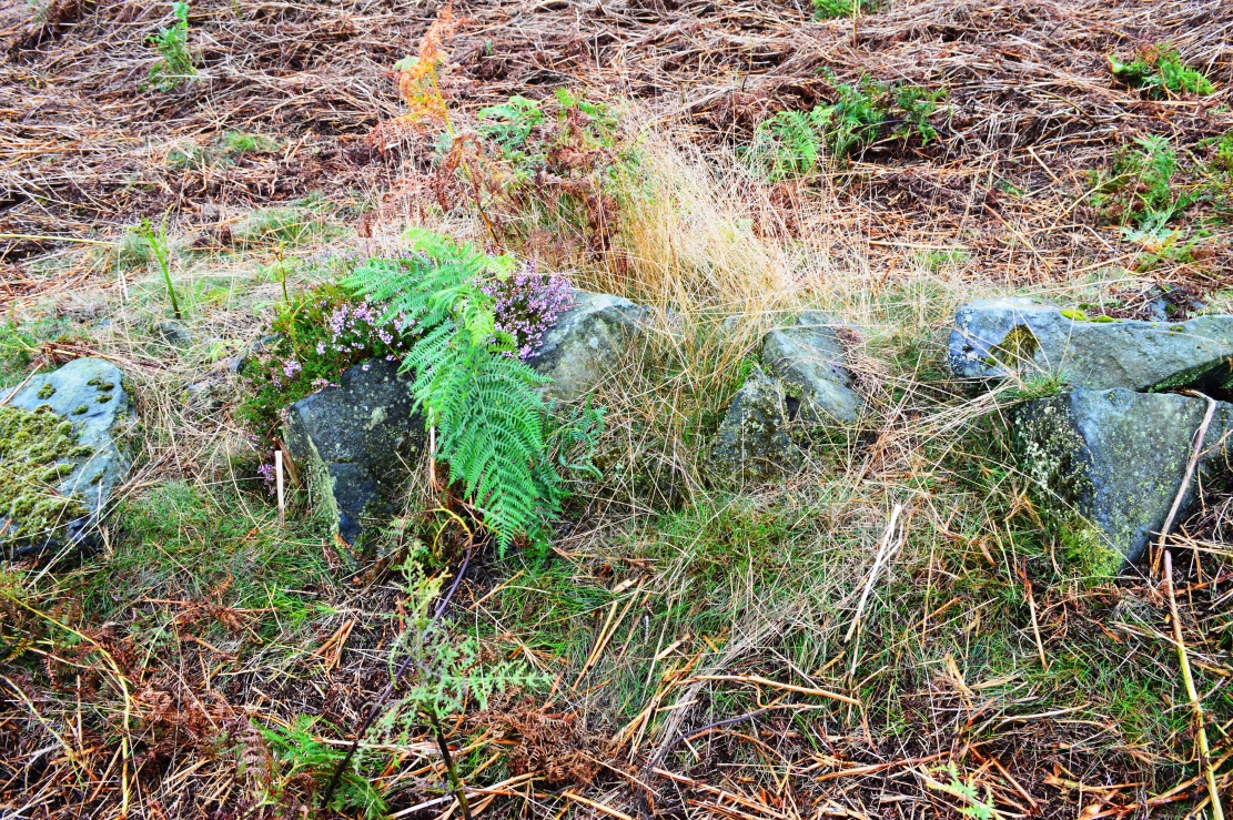
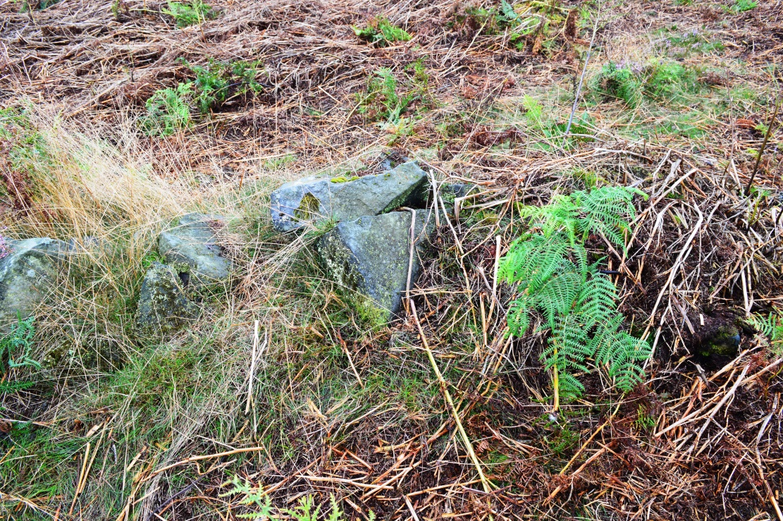
Once found in the small woodland known as the High Plantation, this holy well has, seemingly, long since fallen back to Earth. Mary Manning (1994) included it in her survey where she told that in earlier days it could be seen
“in a field which has drainage ditches and cultivation. Here was formerly marshy land draining to the Nar and lying on the south slope of the Nar valley.”
She thought that the title ‘Silver Well’ meant it was a holy site, but others told that it was due to a silver scum that formed on the surface of the waters—and it was a chalybeate (or iron-bearing spring) this is possible.
It was described in Francis White’s (1854) Directory of Norfolk for Shouldham:
“On Mr. Cotton’s estate is a fine chalybeate spring, called Silver Well, which gives rise to a small rivulet which passes through the village. Near this a new spring was discovered about 20 years ago, and both of them possess similar properties to those of Tunbridge Wells.”
This secondary “spring” was another chalybeate well, above which a stone obelisk was erected in 1839.
Folklore
In relation to the object found in the well, Manning (1994) thinks “the objects found could have been pagan votive offerings in a venerated well.” She also told that:
“The well is the subject of a local legend, which takes two forms. One version is that at the Dissolution, treasure from one of the abbeys was hidden in the well. The second says that workmen repairing the well brought up a container/box of silver ware, which was inadvertently dropped back and never recovered. Both tales attribute the silver colour of the well water to the effect of passing over silver treasure.”
A variation on this was noted by folklorist W.B. Gerish (1892) who told that the silver which the workmen dropped back into the well, did so as a result of the devil fighting them over it, and they fled!
References:
Anonymous, Kelly’s Directory of the Counties of Cambridgeshire, Norfolk and Suffolk, Kelly’s Directories Ltd 1925.
Gerish, W.B., Norfolk Folklore Notes, 1892.
Hope, Robert Charles, Legendary Lore of the Holy Wells of England, Elliott Stock: London 1893.
Manning, M., Taking the Waters in Norfolk, NIAS: Norfolk 1994.
White, Francis, Gazetteer and Directory of Norfolk, 1854.
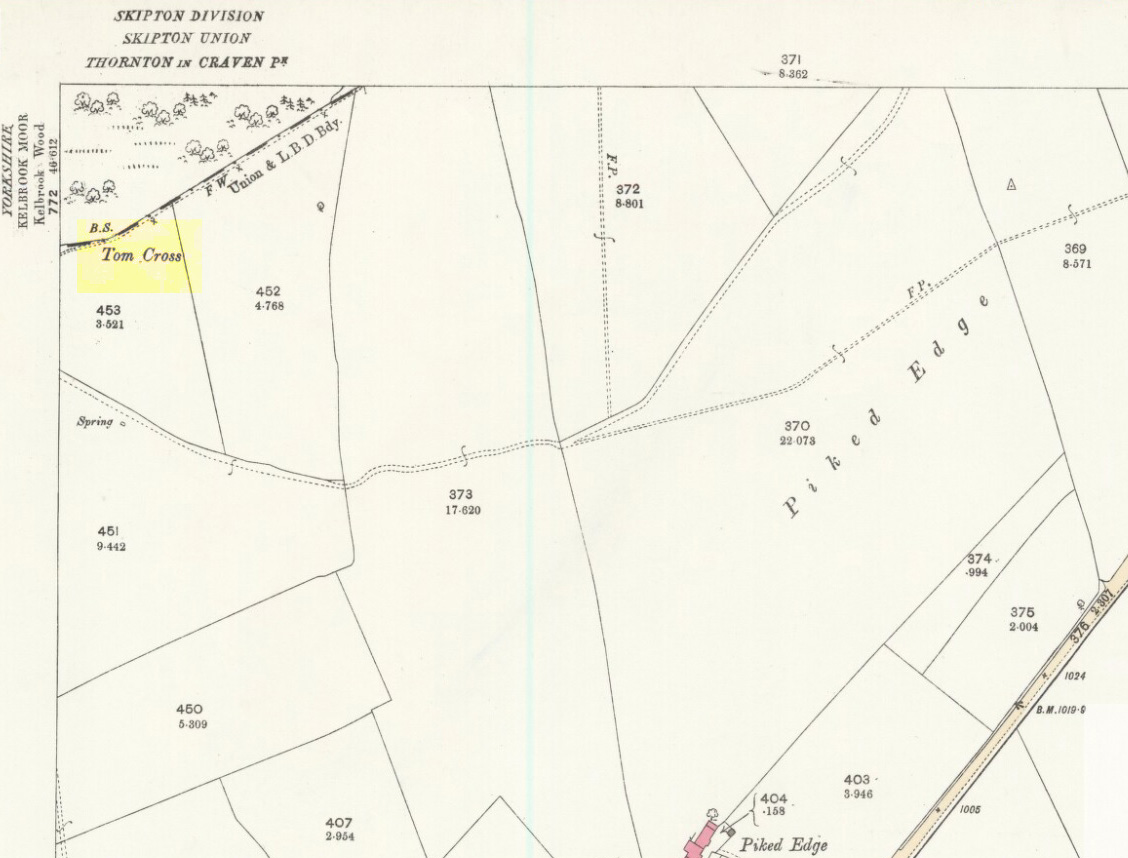
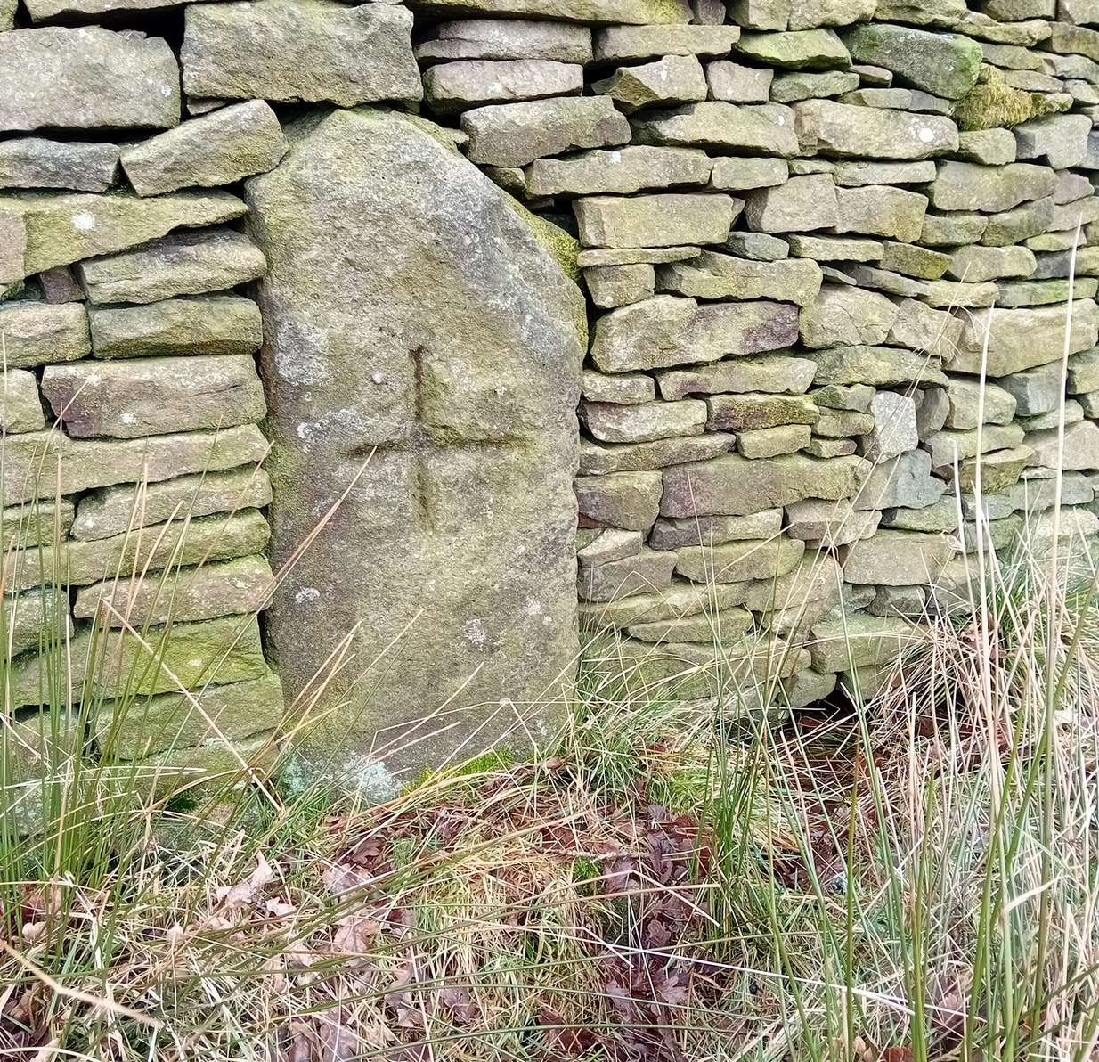
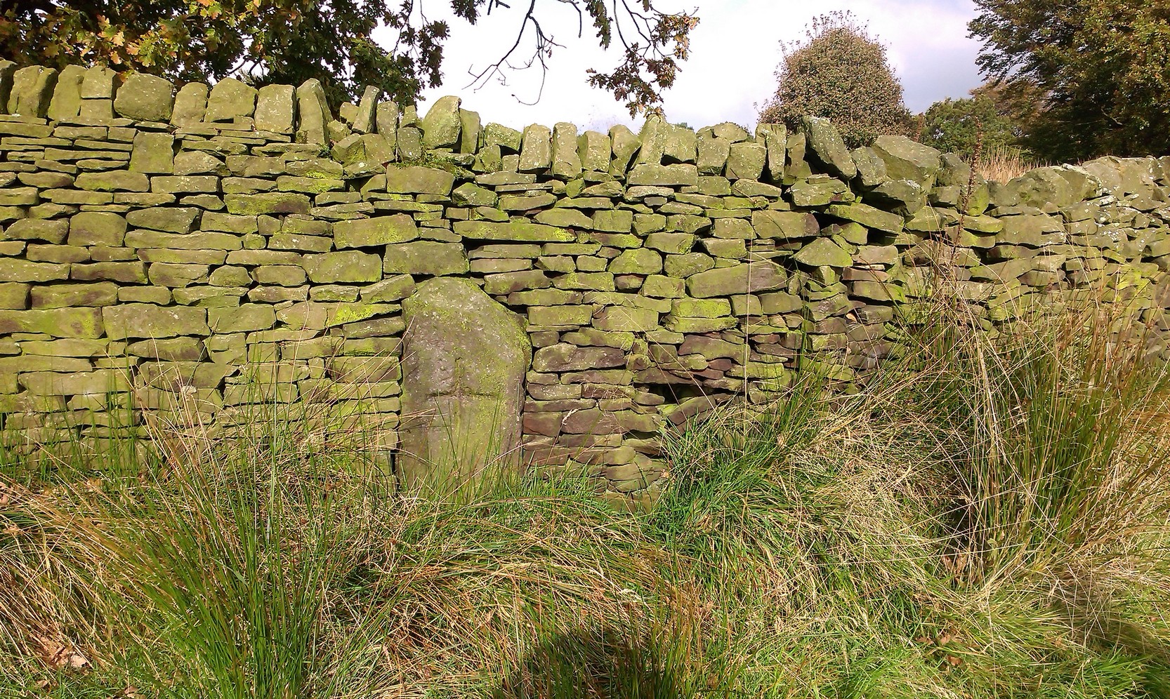
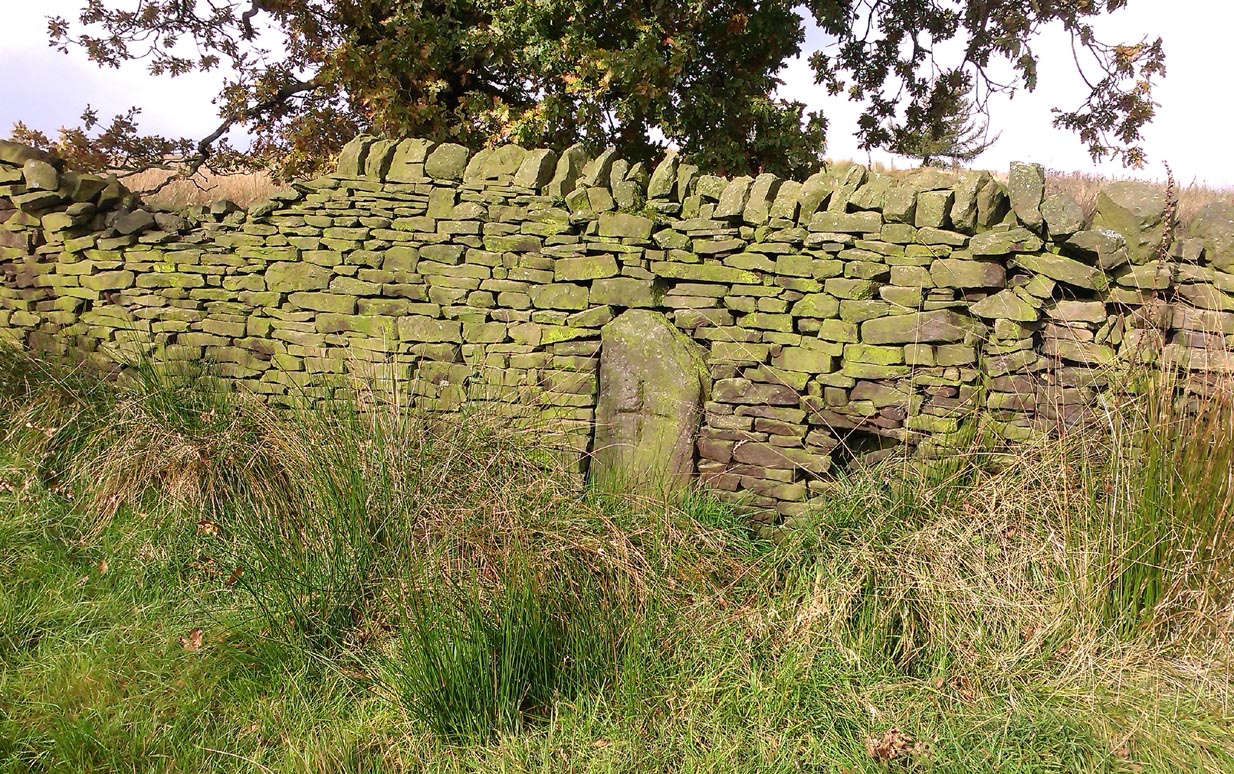
Follow the same directions as if you’re visiting the Dissenter’s Well. The cross stands right next to it!
Archaeology & History
This is one of two old stone crosses with the same name within a mile of each other (the other could be found in the walling along Warley Wise Lane). Included in Taylor’s (1906) stunning magnum opus on the wells and crosses of Lancashire, the site was mentioned in a boundary dispute in the year 1592. He told how a local man called Mr Carr said,
“John Parkinson, ‘of the age of ffour score and thirtiene year or thereabouts’ stated that Tom Cross and the Graystone were by credible report the boundaries, as well of Lancashire and Yorkshire, as of the manors of Colne and Cowling.”
Years later when Clifford Byrne (1974) surveyed the crosses of East Lancashire, he gave us more details about the site, saying:
Photo by Phil WaterworthTom Cross, looking N
“Tom Cross is built into the wall hard by Copy House Farm… At the foot of the Copy House Cross is a well, carved out of a solid block of stone. The water apparently trickles into the well from a spring at the back of the wall , and the overflow spills into the field. The top section of the cross is missing, probably it was vandalized at the time of the Reformation or some time afterwards. It appears that the well was used and probably laid down by the Congregational Church dissenters from the late 17th century. At that time, a law was passed, soon to be repealed, which decreed that every man should attend his Parish Church. This meant that those who wished freedom to practise religion in their own form had to firstly attend the Parish Church and then hold a meeting privately afterwards. At that time, and under those circumstances, it was obviously sensible to meet far away from the Parish Church, and apparently Tom Cross was chosen to meet this need. The children of the Dissenters would be privately baptised in this well at the foot of the monolith into which, a cross was deeply incised.
Tom Cross is mentioned in a lawsuit in the year 1592 and a map exists dated slightly earlier which shows another cross in the area on Greystone Moor near Blacko…”
Tom Cross stone
Byrne suggested that the name ‘Tom Cross’ relates to a boundary cross, but this is not substantiated in local dialect or place-name surveys (who say nothing!). Instead, Joseph Wright (1905) gives us the possibility of Tom being simply, “a kind of rock”; although a variety of other associations relate it children’s games, customs and goblins. The word may derive from the Gaelic ‘tom’, relating to a mound, or clump, or knoll in the landscape (Watson 1926). I’d go for one of these misself. Makes sense.
References:
Byrne, Clifford H., “A Survey of the Ancient Wayside Crosses in North East Lancashire,” unpublished manuscript, 1974.
Taylor, Henry, The Ancient Crosses and Holy Wells of Lancashire, Sherratt & Hughes: Manchester 1906.
Watson, W.J., The Celtic Placenames of Scotland, Edinburgh 1926.
Wright, Joseph (ed.), English Dialect Dictionary – volume 6, Henry Frowde: Oxford 1905.
Acknowledegments: Big thanks to Chris Swales for guiding me to the site; and to the old Teddy Man, DannyTiernan.
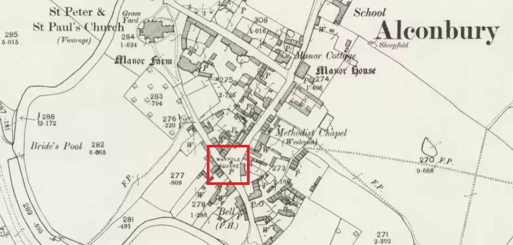
Maypole Square, outlined in red on the 1901 OS map
Maypole Square forms the junction of High Street, Church Way and Chapel Street in the centre of the village.
Archaeology & History
The Alconbury Maypole had passed out of living memory by 1942, but was historically attested by the ‘Maypole Square’ in the centre of the village.
Folklore
C.F. Tebbutt wrote in 1950:
“At Alconbury, it is remembered that about 1890 an old soldier, who lived in the corner house (east end) of the row of cottages facing Maypole Square, used to dig holes in the road opposite the row and set up May bushes there on May day”.
References:
C.F.Tebbutt, “Huntingdonshire Folk and their Folklore”, in Transactions of the Cambridgeshire and Huntingdonshire Archaeological Society, Volume VI, part V, 1942.
C.F.Tebbutt, “Huntingdonshire Folk and their Folklore II”, in Transactions of the Cambridgeshire and Huntingdonshire Archaeological Society, Volume VII, part III, 1950.
Of all the ancient wells in the city of Glasgow, this has to be one of the most intriguing! Descriptions of it are few and far between, but it is the name of the site which is of interest, to folklorists and occult historians alike. For the word ‘Bogle’ is another term for a ‘boggart’ or goblin of some sort! The well is mentioned in Andy MacGeorge’s (1880) excellent study in his description of ancient wells in the city. Citing notes from the 17th century, amidst many sites,
“Another was Bogle’s Well, in regard to which there is a minute of the town council “that Bogillis Well should be assayed for bringing and convoying the water of the same to the Hie street according to the right the town hes thereof,” and the magistrates are recommended to arrange for having this done “by conduits of led.””
…Obviously in the days when they were clueless about lead-poisoning! The word ‘bogillis’ is the early plural form of the bogle, or bogill (Grant 1941:201). But where exactly was this old well? Are there any other records hiding away to help us locate its original position? It seems to have been one in a cluster of legendary and holy wells in a very small area scattered between Glasgow’s cathedral, down the High Street and to the northern banks of the River Clyde… (the grid-reference given for this site is an approximation)
In a less esoteric fashion, the occult historian Jan Silver suggested that the name of the Well may relate to the family name, ‘Bogle’. This could indeed be the real story behind the well’s name.
Folklore
Traditionally ascribed in the lower counties of England to be an evil malicious sprite, in more northern counties and in Scotland the creature was said by Katherine Briggs (1979) to be a more “virtuous creature”, akin to the helpful brownies or urisks of country lore. This was said to be the case in William Henderson’s (1868) Folklore of the Northern Counties. Whether this well was haunted or the home of a bogle, we do not know as the folklore of this site appears to be lost; so I appeal to any students who might be able to enlighten us further on the place. The Forteans amongst you might have a cluster of ‘hauntings’ hereby, perhaps….
Healing Well (destroyed): OS Grid Reference – NS 5974 6534
Also Known as:
Meadow Well
Archaeology & History
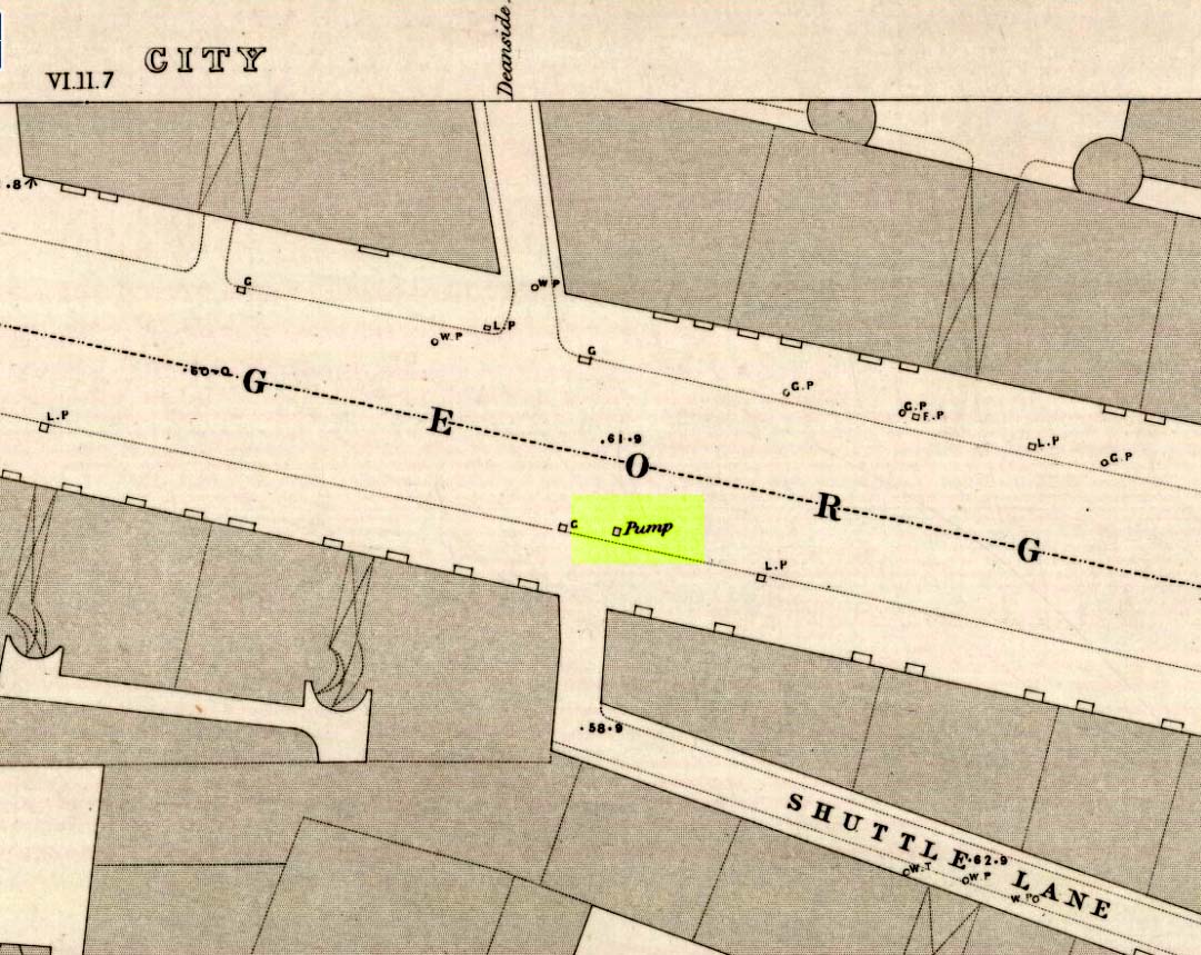
Deanside Well ‘pump’ in 1857
This little-known well—destroyed about two hundred years ago—was said to be one of the finest of all of the water supplies in the Glasgow district in pre-industrial days. The Glasgow historian Andy MacGeorge (1880) told it to be “a spring which was then, and for long afterwards, in great repute.” It was described as early as 1304 CE in a grant by Robert, bishop of Glasgow, allowing the christians to take water from the well and into their convent. The Latin transcript told:
“Noveritis Ros intuita caritatis, Dedisse fratribus Predicatoribus de Glasgu, Fontem quendam qui dicitur Meduwel in loco qui dicitur Denside scaturientem, in perpetuum conducendum in claustrum dictorum fratrum, ad usus necessarios eorundem” (Meaning, “Know ye that I Rosh, of charity, Among His brethren shared with the Preaching Friars of Glasgow, the gushing fountain called Meadow Well or Deanside as the place is called, to the cloisters is said to meet the needs” of the monks.”)
There is the possibility that the well was deemed as ‘holy’ due to it being of vital use to the bishop and monks, but I can find no record of it being ‘blessed’ as such; and the exact site of the bishop’s convent has been lost to history. In 1574 the “Deynside Well” needed cleaning due to people clogging up the waters with earth and stones; and sometime in the 18th century the spring of water was turned into a draw-well.
A northern antiquarian by the name of ‘ Senex’ (real name, Robert Reid) visited the Deanside Well at the end of the 18th century, telling of its whereabouts:
“In the year 1789 I had occasion daily to mount and descend the Deanside Brae, upon business, so that the state of the place at that date is quite familiar to me. The whole of the Deanside Brae was then vacant ground, as is shown in the old Maps of Glasgow. The Deanside or Meadow Well was situated in a meadow at the west end of Grayfriars’ (or Bun’s) Wynd, close to the footpath leading up to the Rottenrow; it is now on the street, at 88 George Street, opposite to the lane leading into Shuttle Street. The Deanside Well was then in a rural spot, the whole lands on the west, as far as Partick, being garden grounds and com fields.
“In Stuart’s Views the lonely foot passage up the Deanside Brae, to the Rottenrow, is very distinctly shown. The well stood at the south extremity of the said footpath, about the centre of the wynd.”
‘Senex’ also told that an ancient fair was held in “an enclosure” at the northwest corner of Shuttle Street, close to the Deanside Well.
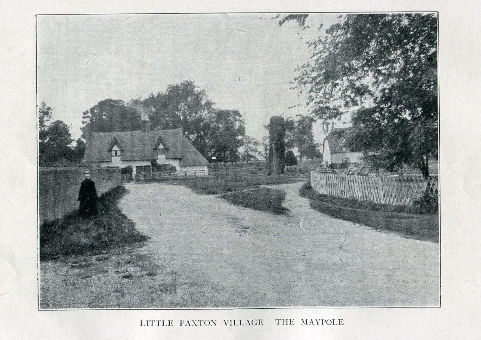
Imposing trunk of The Maypole Tree, right background
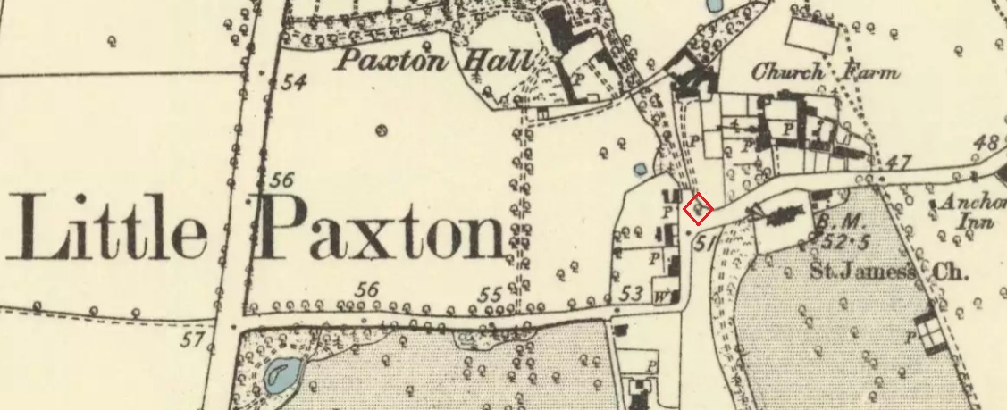
The road layout of the village has changed since the destruction of the Tree, but its approximate position was on the north side of the present High Street, at the junction with the east side of St James’ Road.
Archaeology & History
The Little Paxton Maypole Tree was a very late survival of a tradition where Mayday revellers danced around an actual tree rather than a symbolic tree in the form of a maypole. It was described as “a tall straight elm tree” that stood in front of what was then the village Post Office, and from what may be the only surviving photograph, it appears that only the very substantial trunk survived of what was clearly a very old tree.
1887 6″ OS Map, showing the Maypole Tree outlined in red
A Miss Ethel Ladds, who had been born in Little Paxton, recalled in the early 1940s:
“I remember the old tree very well, it was always called ‘the Maypole’, but I don’t know any more about it, except that they used to dance round it“.
The St Neots Advertiser recorded that the Maypole Tree was blown down in a great gale on 24th March 1895.
Folklore
While this writer has been unable to find direct folklore relating to the Little Paxton Maypole Tree, it may be worth remarking that botanically the Elm tree is a cousin of the Stinging Nettle, the Hop and Cannabis. Another Elm Tree used for May revels was the Tubney Elm, near Fyfield in Berkshire and recorded by Matthew Arnold, in his ‘Scholar Gipsy’.
References:
C.F. Tebbutt, “Huntingdonshire Folk And Their Folklore”, in Transactions of the Cambridgeshire & Huntingdonshire Archaeological Society, Volume VI, Part V, 1942
C.F. Tebbutt, “Huntingdonshire Folk And Their Folklore”, in Transactions of the Cambridgeshire & Huntingdonshire Archaeological Society, Volume VII, Part III, 1950
Gerald Wilkinson, Epitaph For The Elm, Arrow Books, London, 1979
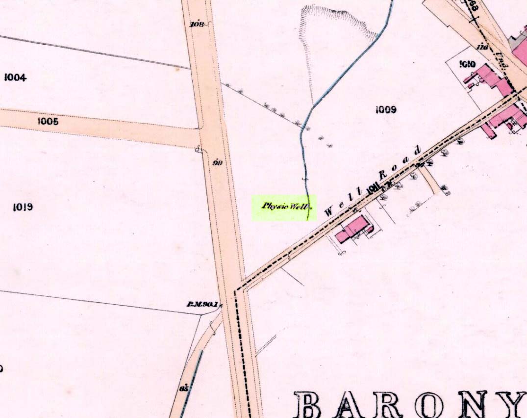
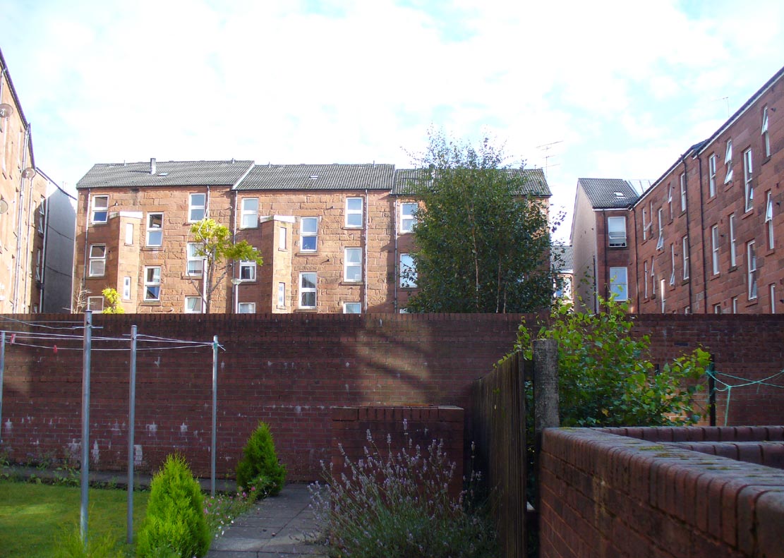
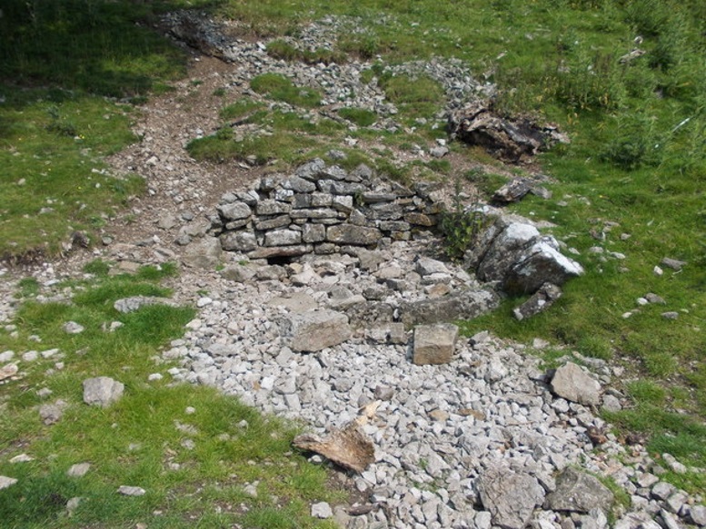
Healing Well (destroyed): OS Grid Reference – NS 5805 6728
Archaeology & History
Physic Well on 1865 map
Any site named as a ‘Physic Well’ anywhere in Britain is, by definition, a spring of water renowned for its medicinal properties. Nowadays however, at this and other sites with the same name, local people aren’t even aware that such places exist. A sad state of affairs indeed… This Physic Well was once found just off Trossach Street in Maryhill—which was once called ‘Well Street’, after the medicinal spring itself—in fields just above the road. Today a small housing estate has been built on top of the site and the only sign of it ever being here appears to be marked by a birch tree in the gardens at the middle of the enclosing buildings.
Birch tree marks the spot!
The site was listed in several early 19th century municipal surveys of Glasgow, but the greater references to it seem to be from local people who described it as a place that was visited annually along the perambulation of the old Barony parish, despite it being just over the edge and into Maryhill. In an extensive footnote in Renwick’s Glasgow Memorials he gives us a fascinating insight into the gatherings at the Well, and the popular customs and social activities of the period:
“William Graham, of Lambhill, aged 69, recollected in his school days, “drinking at a well a very little to the north of the Barony glebe, which was called the Physic Well, and there was then a Royalty stone a little to the west of the glebe.” The Physic Well, perhaps all that effective drainage had left of the former loch, otherwise called ‘Plommaris Hole,’ was utilised at the periodic perambulation of marches for impressing on the memory recollection of this part of the boundary. The means taken for this end may be gathered from the evidence of John Alston, weaver, aged 54, who says that, when he was an apprentice, his master told him that it was a custom, “when the magistrates rode the marches to duck some of the last-made burgesses in the Physic Well”; and, on the same topic, James Bryce, victualler, aged 70, depones that, forty years ago, it was commonly reported in the town that at the marches-riding it was the custom “to duck the youngest town-officer in a well called the Physic Well, which is now filled up, but which was near the Barony glebe.” Janet Paterson, widow of William Paterson, labourer, aged 78, recollects of another well, called the Loanhead Well, in the Barony Glebe, from which she carried water when a young girl. ”About 57 yean ago she saw two ploughs going in the Barony Glebe on the Fast Day of the town Sacrament. In general people wrought the Physic Well Park on the town’s Fast Day, but she never saw them working on the Barony Glebe except on the occasion mentioned.” William M’Culloch, farmer, Lightbum, aged 57, says that when Mr. Hill was minister of the Barony parish, the deponent’s father was employed by him, for a good many years, to plough the Barony Glebe, and on one occasion he recollects the glebe being sown and harrowed upon a Fast Day preceding the town Sacrament. Mr. Hill told his father that the glebe was not within the town’s bounds, that the sowing and harrowing it on the Fast Day could disturb nobody, and that his father could have the sowing finished in time to go to church. Peter Ferguson, weaver, aged 5$, had resided in the neighbourhood of the Barony Glebe from his infancy. When he was a boy he heard it very frequently mentioned by old people, as a common report, that when delinquents or debtors, prosecuted before the town courts of Glasgow, were pursued by the town officers, for the purpose of being apprehended, they were in the practice of endeavouring to get across the Howgate Strand; and if they accomplished this they set the officer at defiance and pointed their fingers at them in derision, as being then without the city’s jurisdiction. Howgate Strand was a small run of water which crossed Castle Street, at the south end of the glebe, then passed through the infirmary grounds and joined the Molendinar Burn a little to the north of the High Church. Another witness, Thomas Alston, manucturer, aged 55, places the fugitives’ point of escape at the north end of the glebe. In his young days it was the practice for the town officers to apprehend boys who were playing on the streets upon the Sabbath and the Fast Days preceding town Sacraments; and he remembered well that it was a common opinion with him and his companions that they were safe from the town officers when they got beyond the Physic Well, on the Glasgowfield road, or beyond the spot marked on Mr. Fleming’s plan ‘Toll-house’, on the Kirkintilloch road, as they considered themselves to be then without the town’s jurisdiction.”
The Well was close to a series of old boundary or ‘merche’ stones, but no ancient ones seem to remain.
The medicinal potential for the water was examined in 1771 by a Dr William Irvine, who found it to be a chalybeate or iron-bearing spring, and to possess “a little muriatic acid”, giving the well both tonic and fortifying properties.
The spring is in the trees. The roof of the church is visible past the tree
Take the B8062 North from Auchterarder, and turn right immediately after crossing Kinkell Bridge. Continue through the hamlet of Trinity Gask, and take the next turn left. The Well is situated in the wooded area of land to your left, before you reach the church on the right. I tried visiting in summer but was beaten back by the boscage of man high nettles, goose grass and brambles. An autumn visit was made, and access was readily available to the wooded area over a barbed wire fence from the field behind the wood.
Archeology & History
The Canmore description quotes from an August 1967 report by an Ordnance Survey inspector:
“Trinity Well is now dry, and all that remains is an overgrown hollow. A manhole cover nearby suggests the spring is now piped.”
On the day of my 2014 visit, the water was flowing from an issue on the field side of the woodland. There was some low walling on the field side of the enclosure, otherwise no masonry or paving was visible. Any there may have been is now either buried or robbed for building material.
The waters still flow despite a 1967 report to the contrary
The 1796 Statistical Account has this to say: ‘ The most noted well in the parish is at Trinity Gask. It is remarkable for the purity and lightness of its water; the spring is copious and perennial. Superstition, aided by the interested artifices of popish priests, raised, in times of ignorance and bigotry, this well to no small degree of celebrity. It was affirmed, that every person who was baptised with the water of this well, would never be seized with the plague….. But the extraordinary virtue of Trinity Gask well has perished with the downfall of superstition, and the introduction of a free and rational enquiry into nature and religion.’
Walling is visible behind the spring issue
The 1837 New Statistical Account goes on to say: ‘….the Trinity Well, a little to the South of the manse, of great renown in Popish days for the performing of miraculous cures, fortifying against plague, witchcraft and such other evils. The right of bleaching at this well is one of the privileges of the minister’.
The Rev. John Wilson writes, in The Gazetteer of Scotland: ‘…a noticeable object is a well famous in Roman times for alleged thaumaturgic properties…’.
Processions to the Well were made on Trinity Sunday and the first Sunday in June
References:
The (First) Statistical Account of Scotland, 1796, Volume 18, page 487
The New (Second) Statistical Account of Scotland, 1837, Volume 10, page 335
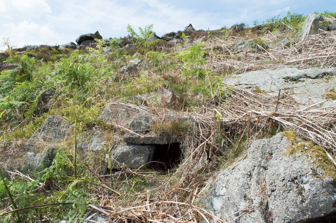
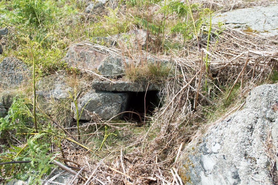
Fairy Mine, Bingley Moor (photo by James Elkington)
This is a strange one. A really strange one….. The site would not have even been written about had it not been for James Elkington pushing me to make its existence visible to a wide audience. As with many sites that I’ve rediscovered, this is one of many that I never seem to write about, for various reasons…although I did do a short piece on it (Bennett 2001) many years back in a little earth mysteries mag, but kept the location quiet. But now, James has got me to change my mind about it. If anyone can throw any light onto what they think this site might be, feel free to let us know. With the exception of is early history, this is its story…
Close-up of the entrance (photo by James Elkington)
One weekend in the early Spring of 1977, Jon Tilleard and I made our weekly wander onto the southern edges of Rombalds Moor, doing little as usual apart from maybe seeking out the curious cup-and-ring stones and other ancient remains, along with walking through the obligatory bogs and wetlands, getting filthy and wet through as healthy kids do at that age. After making our way to Horncliffe Well (generally our first point of call most weeks), we decided to head straight west, off-path as always, and eventually sat ourselves down for something to eat near Wicking Crags on Bingley Moor.
As we packed up again, readying ourselves to walk further onto the moor, John stood upright. In doing so, he dislodged a stone by his feet—right where I was still sitting on the ground!
“Watch out!” he exclaimed loudly—and I quickly rolled forward to get out of the way of the impending stone. Thankfully it wasn’t too big. But then as I turned round to see what had happened, I saw John stood on the small rocky rise he’d been sitting upon—and right beneath his feet, the stone that he’d dislodged had been hiding a very curious secret indeed…
As the photos show, a small opening led into the Earth right underneath where Jon had been sitting. The stone he’d accidentally kicked away had covered and sealed a previously unrecorded entrance. Now, after however many centuries it had been closed and secret, he’d uncovered it again. For us two fourteen-year-old lads gazing into this passageway, our imaginations started running riot!
“What the hell izzit!?”—we must have exclaimed a dozen times or more to each other! To this day, we still don’t know.
I’m not sure how long we stayed here after we’d first found it, but before we left we made sure that the covering stone which had sealed the entrance was propped back upright, securely, so that no one else could find it. The site was quite a way off-path, at the head of a very large boggy area where—to this day—people very rarely walk (in all my years of walking these moors, I’ve yet to see another human walking in this area).
In looking into the tunnel for the very first time, the ground on the outside was of course covered by the usual moorland vegetation; but an inch behind where the stone had sealed this tunnel, the floor was grey dust, all the way in. There were no animal tracks, neither mice nor others, no droppings, no nothing (which we thought was rather unusual). No plants of any form were evident. This ‘door’ had been closed for a very long time it seemed. …Today if you visit the site, ferns and other small plants have encroached several feet into the tunnel.
The entrance itself is about 14 inches across, and from the ground to the top covering stone the entrance is less than 12 inches high, showing quite clearly that no humans can walk in or out of it. Which added to the puzzle: what the hell is it? And why was it sealed with a covering stone? But the more we looked (it became our regular port of call each time we were on the moors) the more obvious it became that a huge amount of work had gone into creating this antiquarian oddity.
As Winter came and cleared all the vegetation surrounding the site, we got an increasingly clear picture of it. But this wasn’t before we tried to get inside! Jon and I failed, but our torches showed that it went in for about 20-30 feet or so and then appeared to be stop, blocked by another stone. Thankfully I had a younger brother, Phil, who was seven-year old at the time—so we took him up to have a look at the place. We figured that only a small person could get inside the tunnel, but we didn’t tell him this (nor my parents!) until we arrived.
With torch in hand, Phil slithered into the entrance and, eventually, his little feet disappeared into the ground. He didn’t seem too happy about it as I remember—but I was his big brother! (cruel – cruel – cruel!) Shouting back down to us as he slithered further and further in, when he reached the blocking stone in the tunnel he exclaimed—”You can go round it!”
“What!? Really!?”
We were excited.
“Keep going Phil,” we urged. But he wouldn’t.
“I’m scared Paul,” he said. “I won’t be able to get back out”—or something along those lines. And he was probably right.
But he managed to get his young tiny body slightly round the blocking stone that he’d reached and shone the torch-light down the extended tunnel. He told that the it just kept going into the hill still further, keeping the same size and dimensions and straightness for about the same distance again—but then it started to curve very slightly, bending to the left (northwest) until it disappeared underneath the entire hillside, stretching out of sight. It seemed from his description, subsequently, that the tunnel went on for another 50 feet at least.
Once he was safely back out, he reiterated how far in it seemed to go. We walked up the hill under which it had been built and Phil bimbled to roughly where he thought the tunnel was as he saw it with the torchlight. Standing on the hilltop, this was obviously an extraordinary feat as there are thousands of tons of rock and earth covering it! Curiously, years later, a dowser who visited the place walked the same route that Phil had described when he went inside it (we told the dowser nothing of Phil’s venture until afterwards).
Denuded walling leading to entrance (photo by James Elkington)Low walling leading to the ‘Mine’ (photo by James Elkington)
When all the moorland vegetation has died back, you can clearly see how the tunnel has been built upon by a large mass of earth and rocks, some of them loose. All round it is an extended collapse of what seems to be quarried stone tumbling down the hillside. At the top of the hill are the remains of old walling and at least two walled structures—although they appear to be post-medieval in nature, not prehistoric. At the entrance itself is evidence of continued walling of some form. It seems as if a wider man-made chamber of some sort may once have stood here, right in front of the present-day entrance. Even if this proves not to be the case, there is very clear evidence that the tunnel which goes into the hillside was once longer, as low walling continues outside away from the entrance, bending away some 50 yards to the southeast, before ending with no indication of additional structural remains. This walled structure swerving out from the entrance is equally perplexing.
The closest prehistoric feature is an unrecorded cairn and petroglyph a few hundred yards away. As far as I’m concerned, this tiny little entrance into the ground isn’t prehistoric. But I’m nonetheless still very intrigued by it, not least because of a few very strange things that subsequently occurred here after we’d discovered it.
Whoever did this, went to a helluva lot of trouble and immense effort to build it. And for what? …Since being opened nearly 40 years ago, very few people have been to see this curious entrance into the Earth. I’ve kept its location hidden. But amongst the visitors has been an archaeologist, a historian, antiquarian authors, occultists and friends. None have been able to say what this site might be. From souterrains to mine-shafts, probably the best suggestion so far was by Mr Paul Hornby who suggested it might have been some sort of kiln, as there seems evidence of fire against one of the stones. But there are anomalies with the site that don’t quite fit the glove of a normal kiln. The extended collapsed ‘tunnel’ which reaches way out, past the entrance which Jon broke in the 1970s, doesn’t make sense; nor the fact that the tunnel goes way into the natural hillside. Indeed, many things here don’t make sense, simply—I presume—because we haven’t asked the right question yet.
But one thing seems obvious: there may be something at the end of this tunnel, deep inside the hill, which someone many centuries ago, for some odd reason, wanted to keep hidden for a long long time. What’s at the end of this tunnel? And if it’s valuable treasure deep in there—it is NOT going to some museum which then, in later years, will be sold off cheaply to some wealthy dood when the museum runs out of money. It should be kept within the safe holdings of The Northern Antiquarian. If this becomes an issue, whatever lies at the end will simply be re-buried elsewhere.
Fortean History
On that fine Spring morning when we first discovered this “mine shaft for little people” as we called it, before we went on our way, we placed the stone that Jon had dislodged that had covered the entrance back into position so that no one could see the opening leading into the ground and under the hill. It was firm and secure when we left—we made sure of it.
The following Sunday morning we made our way back up past Horncliffe Well again and onto this little mine-shaft to sit and have summat to eat. The rocky arena here made it difficult to locate, even though we knew where it was. But when we eventually did find it again, the covering-stone was missing. In fact it had been rolled a good 5 yards away from the entrance. This was odd, we thought—considering that no one even knew of its existence. We wondered if an animal had taken up residence inside, but there were no tracks or remains consistent with this initial idea. We puzzled about it, ate our food, and said our au revoirs. Before we left, we repositioned the covering stone again to block the entrance. This time we made it a little more secure than previously.
The following Sunday morning we visited the site again—and the covering stone had been removed, again! So we replaced it, securely, and visited the place a week later—and the same thing had happened again. This occurred time after time, month after month, year after year. Every single time we covered the entrance, something came and removed it. Yet no one ever comes on this section of the moorland—and even if they did, the site is very difficult to locate. Until now, the site has never been added to any archaeology or history records anywhere—so no one knew of its existence (in asking two of the moorland rangers who’ve worked here over the decades, neither of them knew what we were talking about).
When Andrew Hammond and I left school at 18 (in 1981), we decided as a ritual to bring our school books onto the moor and burn them as the sun was setting in the northwest. We sat near the little mine-shaft and sang our songs of joys at being out of school at last—and as the darkness began to fall over the moor, we replaced the entrance-stone again. Within 30 minutes Nature had cast pitch black across the moor and we fell asleep.
Awaking at sunrise the following day, we wandered down the slope to the little mine-shaft where we’d repositioned the stone only hours previously. It had been moved again, several yards away from the entrance. No animal could have moved it. Whatever it was, it kept doing it every time we repositioned the covering stone. No animal tracks, droppings, or any evidence whatsoever of Nature’s creatures being responsible for the constant removal of the covering stone has ever been found. The constant removal of the covering stone remains a complete mystery.
When a dowser came and tried tracing the underground route of the tunnel in the early 1990s, his rods took him to the top of the rocky hill above, then led him in a small curve to the northwest for more than 100 yards before stopping.
Note:
In the event that archaeologists ever get round to excavating or assessing this site, I would appreciate being contacted before anything is done and would love to be involved in any work performed at the site. I’ll be a good boy! Other remains nearby (usually covered by heather) need appraising to enable a more complete analysis, otherwise all subsequent reports would lack wider archaeocentric contextualization. Thanks, in advance. 🙂
References:
Bennett, Paul., ‘Into a Mythic Domain – a Passage into the Ilkley Underworld,’ in Northern Earth, 87, Autumn 2001.
Acknowledgements: Huge thanks to James Elkington for use of his photos to illustrate this site profile.
The genuine St. Bertram’s well is not easy to find and I recommend using the OS map carefully. It is reached by taking the footpath that leads off at the left passing the cross out of the village. Follow this until the end of the dry stone walling on the right and then divert from the footpath to the right where the well can be seen. The second well is easily found in the field between the church and the Hall.
Archaeology and History
Bertram is an interesting local saint, dating from around the 7th-8th century. Briefly, he is said to be of Royal Irish lineage but after making a princess pregnant, escaped to England where he sheltered in the woods around Ilam. The story is told by Alexander, a monk, in the 13th century who notes:
“They were in hiding in a dense forest when lo ! the time of her childbirth came upon them suddenly ; born of pain and river of sorrow! A pitiful child bed indeed! While Bertellinus went out to get the necessary help of a midwife the woman and her child breathed their last amid the fangs of wolves. Bertellinus on his return imagined that this calamity had befallen because of his own sin, and spent three days in mourning rites”.
As a result he became a hermit living in a cave in the valley near Ilam. Despite the earliest mention being Plot, the local geography is suggestive that this is the site of an early Christian hermitage site, although no mention of a well is noted in his legends it can be noted. Currently, the well is surrounded on four sides by varying low stone walling, about two feet or so at its highest (although it appears to have been built up and down over the time I have visited the well). The spring flows from a small, less than a foot square chamber, enclosed in stone and set into the bank through a channel in the rubble flow and out along the path towards it.
Since the 1990s, on the first Saturday in August, the Orthodox Church makes a pilgrimage to the site and blesses the well. Interestingly, literature available from the National Trust shop fails to mention this well, but notes a more substantial second St Bertram’s Well close by the church and surrounded by a rectangular stone wall with steps down, the water arises here at greater speed and flows into the nearby River Manifold. Visually it is more impressive and more accessible but whether there is any long tradition of this second well is unclear, but authors such as the Thompsons’s (2004) The Water of Life: Springs and Wells of Mainland Britain and Bord (2008) Holy Wells of Britain appear to have fostered its reputation.
Incidentally, the church boasts the remains of St Bertram’s shrine with foramina and the church yard has two Saxon crosses, making a visit to the village a must for those interested in early medieval history.
Folklore
“St Bertram’s Ash… grows over a spring which bears the name of the same Saint… The common people superstitiously believe, that tis very dangerous to break a bough from it: so great a care has St Bertram of his Ash to this very day. And yet they have not so much as a Legend amongst them, either of this Saint’s miracles, or what he was; onely that he was Founder of their Church”
Such notes Plot (1686) The Natural History of Stafford-Shire, the earliest reference of this fascinating site. By Browne (1888) in his An Account of the Three Ancient Cross Shafts, the Font, and St Bertram’s Shrine, at Ilam, noted that the ash had gone, but the water was still being used. He states that:
“The late Mrs Watts Russell always had her drinking water from it.”
Extracted and amended from the forthcoming Holy wells and healing springs of Staffordshire by R. B. Parish (2008)