Holy Well (destroyed): OS Grid Reference – TQ 332 911
Also Known as:
My Lady’s Hole
Archaeology & History
Long since gone after drainage operations on Tottenham Cemetery made the waters dry-up, this was one of several holy wells in the Tottenham area. Its history has been described in various old tomes, but the most definitive is found in William Robinson’s (1840) classic on the parish of Tottenham, when the well was still visible. He told us:
“There is a spring which issues from the side of a small hillock on the south side of the Moselle, nearly opposite the Vicarage, leading thence to the Church, called Bishop’s Well. This spring was formerly considered famous for many strange and wonderful cures performed on the diseased by the use of this water. It has been for some years neglected, but of late the owner of the field in which this well is, had it cleansed, and planted some trees round it, and put up posts and rails to prevent the cattle treading down the sides of it. It is said that the water of this well never freezes. In former times this well was in great repute from the purity of its water. The ladies in the vicinity of it were accustomed to send their servants in the morning and evening for water for their tea, from which circumstance it was for many years known by the name of “My Lady’s Hole.” The water of this well is not only esteemed for its medicinal qualities, but particularly for curing disorders of the eye.
“There were formerly many other springs about the village, especially one which issued out of the hill on which the Church stands; and another in Spottons Wood otherwise Spottons Grove, on the north side of Lordship Lane, which in the fifteenth century was of considerable notoriety; but none of which have in former times been so much frequented and held in such repute as Bishop’s Well.”
(Please note: the grid-reference for this site is an approximation)
References:
Foord, Alfred Stanley, Springs, Streams and Spas of London: History and Association, T. Fisher Unwin: London 1910.
Hope, Robert Charles, Legendary Lore of the Holy Wells of England, Elliott Stock: London 1893.
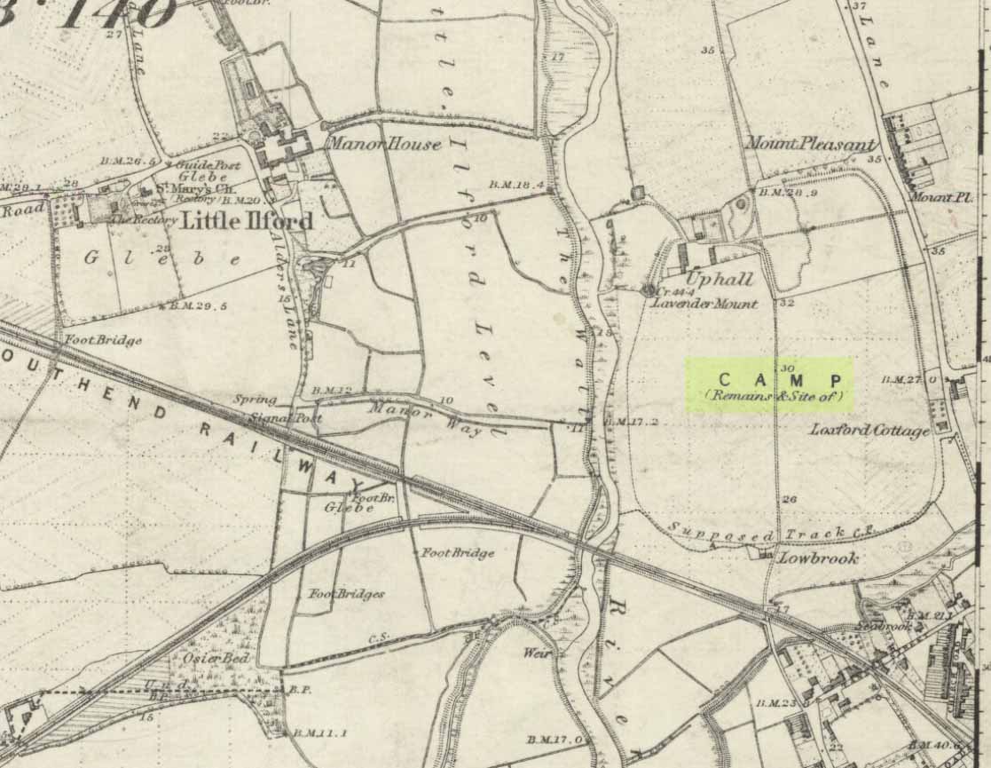
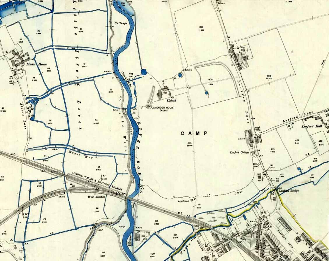
Hillfort (destroyed): OS Grid Reference –TQ 4383 8510
Archaeology & History
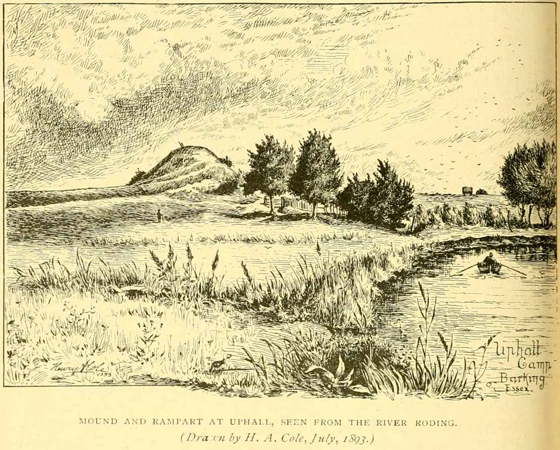
Uphall Camp, 1893
This prehistoric site was a giant – a huge colossus of an ‘enclosure’, a ‘settlement’, a ‘camp’—call-it-what-you-will. More than a mile in circumference and with an internal area of 48 acres (big enough to hold 37 football fields!), archaeologist Pamela Greenwood (1989) told us, not only that it was “the largest recorded hillfort in Essex”, but that it compared in size with the immensity of Maiden Castle in Dorset! Yet despite it being cited by the Oxford Archaeology report of Jonathan Millward (2016) as “the most significant archaeological site within the Borough” from the Iron Age period, it has fallen prey to the thoughtless actions of the self-righteous Industrialists who, as usual, have completely destroyed it. It was already in a “bad” state when the Royal Commission lads visited here around 1916, saying how it was “in some danger of destruction.” Thankfully, in earlier centuries, we did have more civilized and educated people who seemed proud to describe what there was of their local history.
Early literary accounts seem sparse; although in Mr Wright’s (1831) huge commentary to Philip Morant’s (1768) Antiquities of Essex, he thought that the adjoining parish of Barking—whose ancient boundary line is marked here by the southern embankments of the enclosure—derived from the Saxon words burgh-ing, which he transcribed as ‘the fortress in the meadow’. The same derivation was propounded in Richard Gough’s 1789 edition of Camden’s Britannia, from the “Fortification in the meadows.” It seems a more reasonable derivation than that ascribed in the Oxford Names Companion (2002) as the “(settlement of) the family or followers of a man called *Berica” (the asterisk here denotes the fact that no personal name of this form has ever been found and is pure guesswork). But according to the English Place-Name Society text on Essex by Paul Reaney (1935), the early spellings of Barking implies a derivation from ‘birch trees.’ Anyway….
Uphall Camp c.1735
A fine plan of the site was drawn by John Noble some time around 1735 although, curiously, he seems to have written no notes about the place. The first real citation of Uphall Camp as an antiquity seems to have been by Morant himself (1768). In a work bedevilled by genealogical and ecclesiological tedium, he occasionally breaks from that boredom to tell of the landscape and the people living here, mentioning our more ancient monuments—but only in passing, as illustrated here:
“Near the road leading from Ilford to Berking, on the north west side of the brook which runs across it, are the Remains of an ancient Entrenchment: one side of which is parallel with the lane that goes to a farm called Uphall; a second side is parallel with the Rodon, and lies near it; the third side looks towards the Thames; the side which runs parallel with the road itself has been almost destroyed by cultivation, though evident traces of it are still discernible.”
Just over thirty years later we were thankfully given a more expansive literary portrayal by Daniel Lysons. (1796) Lysons was drawing some of his material from a manuscript on the history of Barking by a Mr Smart Lethieullier, written about 1750 (this manuscript was unfortunately destroyed by fire, and no copies of it ever made). He told us:
“In the fields adjoining to a farm called Uphall, about a quarter of a mile to the north of Barking-town, is a very remarkable ancient entrenchment: its form is not regular, but tending to a square; the circumference is 1792 yards, (i.e., one mile and 32 yards,) inclosing an area of forty-eight acres, one rood, and thirty-four perches. On the north, east, and south sides it is single trenched: on the north and east sides the ground is dry and level (being arable land), and the trench from frequent ploughing almost filled up: on the south side is a deep morass: on the west side, which runs parallel with the river Roding, and at a short distance from it, is a double trench and bank: at the north west corner was an outlet to a very fine spring of water, which was guarded by an inner work, and a high keep or mound of earth. Mr. Lethieullier thinks that this entrenchment was too large for a camp: his opinion therefore is, that it was the site of a Roman town. He confesses that no traces of buildings have been found on that spot, which he accounts for on the supposition that the materials were used for building Barking Abbey, and for repairing it after it was burnt by the Danes. As a confirmation of this opinion, he relates, that upon viewing the ruins of the Abbey-church in 1750, he found the foundations of one of the great pillars composed in part of Roman bricks. A coin of Magnentius was found also among the ruins.”
But this is a spurious allusion; albeit an understandable one when one recognizes that the paradigm amongst many writers at the time was to say that anything large and impressive was either a construction of the Romans or the Danes, as the early British—it was deemed—were incapable of building such huge monuments. How wrong they were!
In Mrs Ogborne’s (1814) description of Uphall Camp, she thought that its form and character betrayed anything Roman and—although she wasn’t specific—seemed to prefer the idea that our earliest Britons had built this place. And she was right! She wrote:
“There is, about a quarter of a mile from Barking, adjoining Uphal farm, on the road to Ilford, an antient entrenchment, a mile and 32 yards in circumference, with the corners rounded off; the west side, parallel with the river Rodon, has a double trench and bank, and a high keep, or mound of earth, about 94 yards round the base, about nine in height, on the side of the river, and seven on the opposite side: there was an outlet to a spring of water at the north-west corner; the south side has a morass; the north and east sides are single trenched, which is almost lost by cultivation, and in some places barely discernible.”
Uphall Camp on 1873 map
Uphall Camp on 1897 map
When the Ordnance Survey lads gave the site their attention in the 1870s, they showed its real size for the first time—cartographically at least! As the two old maps either side here show, it was a big one! Although some sections of the edges of the ‘camp’ were diminishing at the time, much of it was still in evidence. And when the local writer Edward Tuck (1899) wrote about it, he told us,
“On the north and east sides the ground is dry and level (being arable land) and the trench from frequent ploughings is almost filled up. On the south side is a deep morass; on the west side which runs parallel with the river Roding, and at a short distance from it is a double trench and bank; at the north-west corner is an outlet to a very fine spring of water, which is guarded by an inner work and a high keep or mound of earth designated “Lavender Mound.” Mrs. Ogborne in her History of Essex gives a charming drawing of this mound as it was in 1814, and says that the mound was then about 94 yards round the base, and about nine yards in height, with trees growing upon it, and its surface covered with soft verdure.”
Uphall earthworks in 1893
Several other writers mentioned the remaining embankments of Uphall Camp, which was beginning to fade fast as the city-builders spread themselves further afield. A chemical factory did most of the damage (as they still do, in more ways than one!). When the Royal Commission (1921) lads came here they curiously deemed it as an “unclassified” structure; but in those days unless things were Roman in this neck of the woods, it could unduly puzzle them! Their account of it told that,
“the remaining earthworks consist of a short length of rampart with an irregularly shaped mound at the north end, which is known locally as Lavender Mount, and another short length north of the farmhouse; there are also traces of the east side of the camp running parallel with Barking Lane. An early plan shows part of the north and east sides of the earthwork and suggests that it was roughly rectangular in outline. In 1750 the north, east and south sides are said to have had a single trench, and the west side a double trench and bank.
“The mound is 21 ft. high and 85 ft. in diameter at the base. The date of the earthwork is doubtful, but it does not appear to be pre-Roman.”
1908 photo of Lavender Mount
1814 sketch of Lavender Mount
The ‘Lavender Mount’ aspect in this monument, seemed a peculiar oddity. Even modern archaeologists aren’t sure of what it might have been, erring on the side of caution with interpretations saying it was a keep of some sort, or a small beacon hill. It might have been of course; but if it was a beacon hill, there would very likely be some written account of it – but none exist as far as I’m aware. Initial impressions when just looking at the images is that it was a tumulus, but the position of the mound on top of the raised earthen embankments tells us that it was constructed after the Iron Age ramparts. Writers of the Victoria County History (1903) said the same, suggesting a Saxon or more likely Danish origin. The area around Lavender Hill was eventually explored by archaeologists in 1960, and several times thereafter – and what they uncovered showed us a continuity of usage that spanned several thousand years!
The 1960 excavation took place where, adjacent to the embankment, “the bank and ditch contained middle-Iron Age pottery”, along with traces of the large wooden fencing-posts (palisade) that initially surrounded and protected the enclosure. In Pamela Greenwood’s (1989) archaeological report, she told us that in further digs in 1983-4 there were discoveries of neolithic and Bronze Age flint remains. The finds included,
“a leaf-shaped arrowhead and a discoidal scraper… fragments of an Ardleigh type urn, probably from a middle Bronze Age burial disturbed by later activity. An L-shaped ditch, possibly part of an enclosure or field boundary, was found during the watching-brief. It contained flint-gritted pottery, perhaps attributable to the Bronze Age.”
But the majority of the finds at Uphall came from the mid-Iron Age period. Greenwood continued:
“The settlement, judging from the relatively small area of the fortification actually excavated, was laid out in a regular way. As might be expected, the round-houses appear to be aligned, indicating some sort of street-pattern. ‘Four-poster’ structures have been located in particular areas, again pointing to some sort of designation of special zones of activity. Large quantities of charred grain from the post-pits and surroundings would confirm that these structures are granaries….
“The middle Iron Age structures are of several types: round-houses or round-buildings, pennanular enclosures, (wooden) ‘four-posters’; rectangular structures, ditches, post-holes and innumerable and ill-assorted small pits, small gullies and holes dug into the gravel. Many of the last three types are undatable and could belong to the Iron Age, Roman, medieval or later activity on the site.”
I could just copy and paste the rest of Greenwood’s report here, but it’s quite extensive and interested readers should refer to her own account in the London Archaeologist . It’s a pity that it’s been destroyed.
Tumulus (destroyed): OS Grid Reference – TQ 288 726
Archaeology & History
This long lost prehistoric tomb is one of many that has fallen under the destructive hammer of the christian Industrialists in this part of the country. Located somewhere in the parkland grounds of Bedfordhill House (also destroyed), its memory was thankfully preserved by the renowned folklorist and historian Walter Johnson (1903) who wrote of it in his work on prehistoric Surrey, where he told:
“A few years ago a supposed barrow was levelled in Bedford Park, Bedford Hill, Tooting, and no record taken of the results. The mound was enclosed in the Park for several centuries, but when the grounds were laid out for building purposes ten or a dozen years since, it suffered rough usage, and was finally destroyed. It was nearly 100 yards long, and about 20 feet in breadth in its highest part. It ran East and West, and had several trees growing on it before its desecration…. A moat had been made round the mound for about two-thirds of its circuit. This moat was supplied with water by the Ritherdon, a small stream rising in Streatham. The name is preserved in the adjacent Ritherdon Road. The material of the mound was gravel and gravelly loam, which, in the neighbourhood, occurred only in a thin layer, thus forbidding the conclusion that the structure was merely composed of the soil dug out in making the moat. The excavated material would largely be London Clay. As the genuineness of this barrow was, we believe, called in question after its demolition, when the subject was beyond reconsideration, we mention two shreds of collateral evidence. The ground on which the tumulus stood was about the highest in the district. The name Tooting may also have some bearing, for Mr. Clinch thinks that it was a Celtic settlement where was worshipped the deity known as Taith. (Compare also toot-hill, as exemplified in Tot Hill, Headley, Tothill Fields, Westminster, famous for fairs and tournaments, also Tutt Hill, near Thetford.)”
The ‘toot’ in Toothill however, is ascribed by Gover, Mawer & Stenton (1934) as being the usual “look-out hill”. Although they do make note of the fact “that there is no hill in Tooting which would make a good look-out place.” But if this was a large barrow of some type, it would explain the etymological oddity. Any further information on this site would be welcome.
References:
Gover, J.E.B., Mawer, A. & Stenton, F.M., The Place-Names of Surrey, Cambridge Univserity Press 1934.
Johnson, Walter, Neolithic Man in North-East Surrey, Elliot Stock: London 1903.
Smith, A.H., English Place-Name Elements – volume 2, Cambridge University Press 1954.
Holy Well (destroyed): OS Grid Reference – TQ 4421 8484
Archaeology & History
Barely 200 yards to the immediate southeastern edge of the once gigantic hillfort of Uphall Camp, could once be found an old holy well, last recorded it would seem in 1456. The site was located just yards to the south of the old boundary that separates the parishes of Ilford and Dagenham. Its location was described in the Victoria County History:
“A mile south of Ilford Bridge the Roding is joined by Loxford Water, a stream rising near Hog Hill, in Dagenham, and known in its upper reaches as Seven Kings Water. In 1456 the lower part of the stream was called Halywellbrooke.”
We also have an account in the Barking Abbey Rental, which told us there was “land in Longland at Halywellbrooke”, as well as “pasture lying at the northern head of Luzias land…near Halywell and…at Loxfordbrigge.” (Harte 2008) It has long since been destroyed.
Holy Well (covered): OS Grid Reference – TQ 3157 8111
Archaeology & History
St Brides Well on 1896 map
Close to the centre of that corporate money-laundering place of homo-profanus that is the City of London, was once a site that represents the antithesis of what it has become. Tacked onto the southeastern side of St. Bride’s church along the appropriately-named Bride Lane, the historian Michael Harrison (1971) thought the Holy Well here had Roman origins. It “was almost certainly,” he thought,
“in Roman times, the horrea Braduales, named after the man who probably ordered their construction: Marcus Appius Bradua, Legate of Britain under Hadrian, and the British Governer in whose term of office the total walling of London was, in all likelihood, begun.”
This ‘Roman marketplace of Bradua’ that Harrison describes isn’t the general idea of the place though. Prior to the church being built, in the times of King John and Henry III, the sovereigns of England were lodged at the Bridewell Palace, as it was known. Mentioned in John Stow’s (1720) Survey of London, he told:
“This house of St. Bride’s of later time, being left, and not used by the Kings, fell to ruin… and only a fayre well remained here.”
The palace was eventually usurped by the building of St. Bride’s church. The most detailed account we have of St. Bride’s Well is Alfred Foord’s (1910) magnum opus on London’s water supplies. He told:
“The well was near the church dedicated to St. Bridget (of which Bride is a corruption; a Scottish or Irish saint who flourished in the 6th century), and was one of the holy wells or springs so numerous in London, the waters of which were supposed to possess peculiar virtues if taken at particular times. Whether the Well of St. Bride was so called after the church, or whether, being already there, it gave its name to it, is uncertain, more especially as the date of the erection of the first church of St. Bride is not known and no mention of it has been discovered prior to the year 1222. The position of the ancient well is said to have been identical with that of the pump in a niche in the eastern wall of the churchyard overhanging Bride Lane. William Hone, in his Every-Day Book for 1831, thus relates how the well became exhausted: ‘The last public use of the water of St. Bride’s well drained it so much that the inhabitants of the parish could not get their usual supply. This exhaustion was caused by a sudden demand on the occasion of King George IV being crowned at Westminster in July 1821. Mr Walker, of the hotel No.10 Bridge Street, Blackfriars, engaged a number of men in filling thousands of bottles with the sanctified fluid from the cast-iron pump over St. Bride’s Well, in Bride Lane.” Beyond this there is little else to tell about the well itself, but the spot is hallowed by the poet Milton, who, as his nephew, Edward Philips records, lodged in the churchyard on his return from Italy, about August 1640, “at the house of one Russel a taylor.”
In Mr Sunderland’s (1915) survey, he reported that “the spring had a sweet flavour.”
Sadly the waters here have long since been covered over. A pity… We know how allergic the city-minds of officials in London are to Nature (especially fresh water springs), but it would be good if they could restore this sacred water site and bring it back to life.
Folklore
Bride or Brigit has her origins in early British myth and legend, primarily from Scotland and Ireland. Her saint’s day is February 1, or the heathen Imbolc (also known as Candlemas). Although in christian lore St. Bride was born around 450 AD in Ireland and her father a Prince of Ulster, legend tells that her step-father (more probably a teacher) was a druid and her ‘saintly’ abilities as they were later described are simply attributes from this shamanic pantheon. Legends—christian and otherwise—describe Her as the friend of animals; possessor of a magickal cloak; a magickian and a healer; and whose ‘spirit’ or genius loci became attached to ‘sacred sites’ in the natural world, not the christian renunciation of it. St Bride was one of the primal faces of the great prima Materknown as the Cailleach: the Gaelic deity of Earth’s natural cycles, whose changing seasons would also alter her names, faces and clothes, as Her body moved annually through the rhythms of the year. Bride was (and is) ostensibly an ecological deity, with humans intrinsically a part of such a model, not a part from it, in contrast to the flawed judaeo-christian theology.
References:
Foord, Alfred Stanley, Springs, Streams and Spas of London: History and Association, T. Fisher Unwin: London 1910.
Gregory, Lady, A Book of Saints and Wonders, Colin Smythe: Gerrards Cross 1971.
Harrison, Michael, The London that was Rome, Allen & Unwin: London 1971.
McNeill, F. Marian, The Silver Bough – volume 2, William MacLellan: Glasgow 1959.
Cross (destroyed): OS Grid Reference – TQ 3077 8093
Also Known as
Stone Cross of the Strand
Archaeology & History
First mentioned in Latin manuscripts from 1274 CE, the best description of this long lost monument, curiously, appears to be in Gover’s Place Names tome. In a slightly edited format he told us the following:
“There was a stone cross “without the bar of the New Temple” traditionally supposed to have been erected by William Rufus “in devotion to the Holy Cross and for the health of the souls of himself and his mother, Queen Maud… It was in the Strand, possibly on the site of the present church of St. Mary. It is referred to as crucem lap’ in 1274; la Crois de Piere in 1293; …Stonecrouch in 1337; crucem fractum in 1342…”
In subsequent notes Gover et al (1942) tell of a man they found in historical records to be Thomas le Barber, “described alternatively as being Thomas le Barber atte Stonecourche” in the Calendar of Rolls records of 1337, and again in the 1339 accounts.
Of the cross itself, information is minimal and scattered. It was destroyed several centuries ago but is mentioned in a number of old books on the history of the city. The historian Thomas Allen (1829), for example, told that
“opposite to Chester Inn stood an ancient cross. On this cross in the year 1294, the judges sat to administer justice, without the City.”
It was also a site where legal pleas for the county of Middlesex were to be held, at “the Stone Cross of lad Straund” as it was then known. Due to the early administrative function delivered from this cross, it strongly implies the place to have been a moot site prior to the erection of the cross, probably dating from the period in which tribal elders met here.
A Mr Newton tells in his London in the Olden Time that the top of the cross was damaged and knocked off by the crazy christians around the time of the Reformation and that for many years stood headless. When Vallance (1920) came to describe it, he told merely that,
“the Strand Cross, near Covent Garden. This cross was hexagonal on plan, and comprised four stages. It was standing in 1547, but was ultimately removed, its site being occupied by the Maypole, which was spoken of in 1700 as new.”
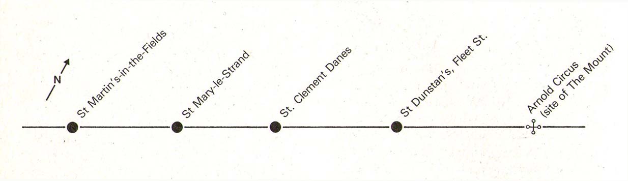
The Strand Cross would have been on the ancient ley (not one of those ‘energy lines’ invented by New Age fantasists) described first of all by Alfred Watkins (1925)—running from St. Martins-in-the-Field to St. Dunstan’s in Fleet Street—but he seems to have been unaware that the monolith ever existed. The alignment was subsequently described in more detail in Devereux & Thomson’s (1979) work on the same subject, but its existence seems to have evaded them too! Chris Street (2010) did include it in his much more detailed walk down the same ley. A maypole was also known to exist close to the site of the cross; with one account showing that the two monuments existed at the same time in 1543.
As the site seemed to have been an early moot spot, the Strand Cross may have been an omphalos in early popular culture (before the christians of course), or at the very least, a site of popular animistic tradition.
Cross (destroyed): OS Grid Reference – TQ 3180 8181
Archaeology & History
Site of Cow Cross on 1896 map
Not far from the long lost Fag Well could once be seen this old stone monument. Although not illustrated on the first Ordnance Survey maps of the inner city, it is highlighted on the 1896 edition (as shown here), just where Cow Cross Street meets Charterhouse Street—right by the boundary line—and is marked as ‘Site of Cow Cross’.
The cross gained its named from the cattle market that was held here from very early times, on the boundary of the lands of the Knights Hospitallers in the 12th century. Cattle itself–both horses and cows—were actually slaughtered at the market by the cross: a practice that has thankfully stopped (in public at least). Despite the place-name being referenced in many early accounts, actual descriptions of the cross are few and far between due to it being destroyed at quite an early date. When John Stow came to write his history of London in 1603, he told that it was no longer standing. Whether the cross replaced an earlier standing stone, we simply do not know…
References:
Gover, J.E.B., Mawer, Allen & Stenton, F.M., The Place-Names of Middlesex, Cambridge University Press 1942.
In truly that most unholy of places in England—Westminster, London—there was, in bygone times, a slightly more sacred site which, earlier still, might have been where a standing stone stood…. Might…. But such days are long gone down there. A gathering place of local people in very early times, the Broken Cross was, according to Vallance (1920),
“erected by the Earl of Gloucester in the reign of Henry III (1216-1272), but it did not stand very long. Its site is said to have been ‘the place of the meeting of the Folkmote…near St. Martin’s-le-Grand, about midway between the Northgate of the precinct (of St. Paul’s) and the church of St. Vedast.’ On 5th September 1379, agreements were drawn up for letting the stations about the Broken Cross to five divers persons. The cross was bodily taken down in 1390.”
Yet its name was maintained in street-names for many years later, simply as ‘Broken Cross’. Its position would have been very close to Cheapside.
George Gomme (1880) pointed out that such early folk moots were the development of tribal gatherings grafted from megalithic meetings onto early christian assemblies, pointing out how such assemblies for laws and councils were made at nearby St. Paul’s as early as 973 AD.
This settlement site was found thanks to the good work of the Bromley & West Kent Archaeology Group in the 1960s, when they decided to do follow-up work to what Brian Philp (2002) described as “doubtful sites reported mainly in the 19th century.” Time and again these “doubtful sites” at least turn into something of value — and such was the case here! The group commenced digging selective trenches in July 1964 in a small wooded area near to Baston Manor and they soon came across “a stratified deposit of late-Neolithic (2500 BC) pottery and flint.”
In successive returns to the site over two years, 5630 items—primarily fire-cracked stones, flints and more than 200 pieces of pottery, some of which was highly decorative—were unearthed and the site was recognised as an important settlement arena many thousands of years ago. In Kent, this was a rarity! Philps’ resumé of the site and its many remains told,
“Sometime about 2500 BC, a group of late-Stone Age farmers had selected this quiet hillside (now just in Hayes) to settle and live. Here they must have farmed small cultivated areas close to their huts and herded sheep and cattle to fresh areas and nearby streams. These were the first occupants of the West Wickham valley over 4000 years ago…”
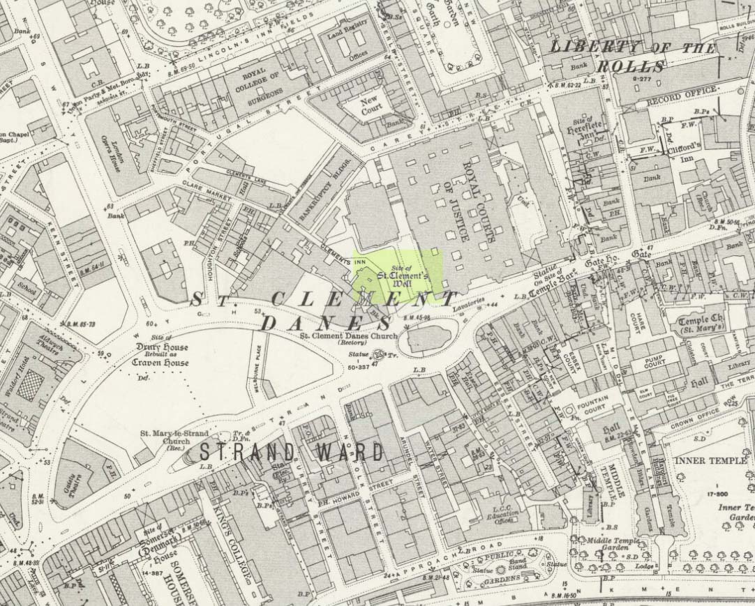
Holy Well (destroyed): OS Grid Reference – TQ 3096 8106
Archaeology & History
Close to the long-lost Strand Cross and long-lost Strand Maypole, in bygone centuries was also to be found a holy well of great repute, dedicated by early christians to the sea-faring St. Clement. Its presence was recorded in the ‘Holywell Street’ name at far the eastern end of The Strand but, like its compatriot monuments, it too is long-lost… Thankfully we have reasonably good accounts of its existence, although its precise whereabouts has been something of a matter of debate.
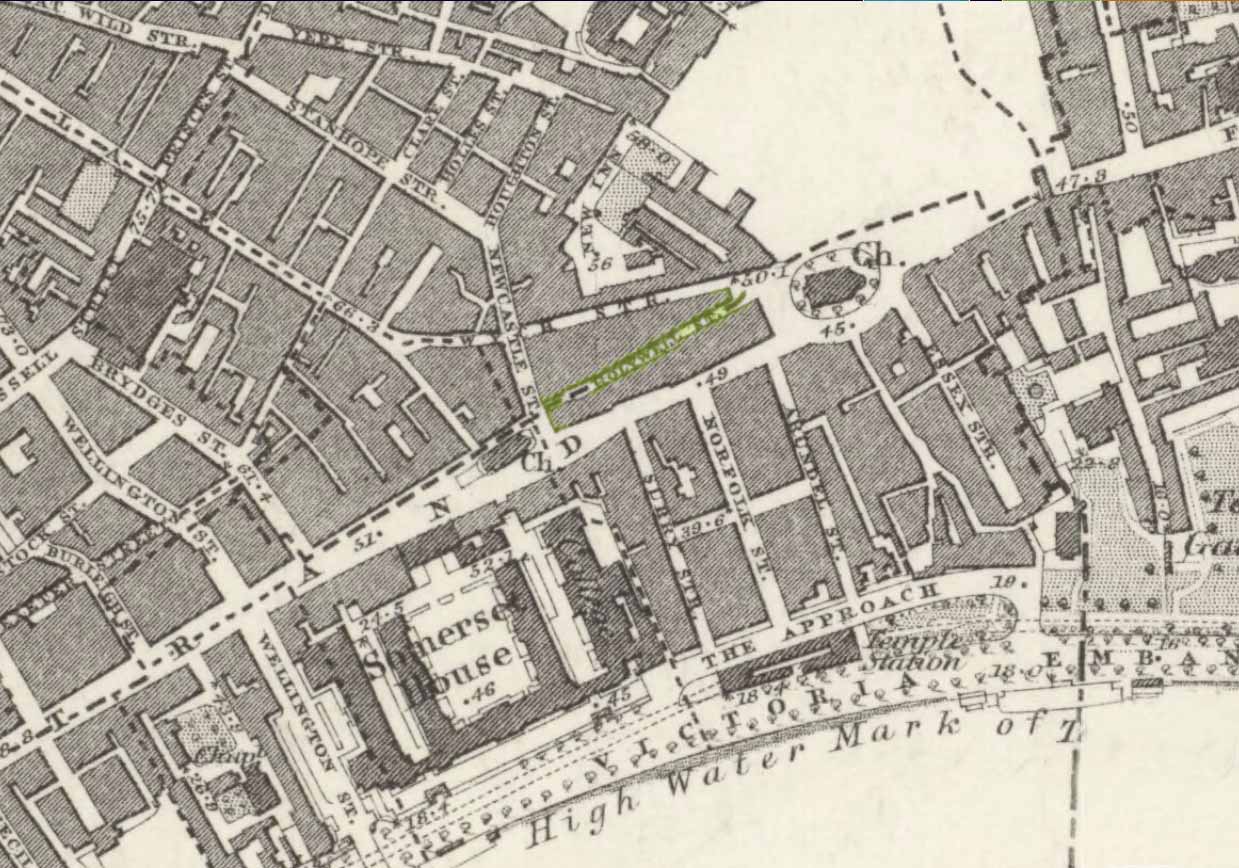
Holywell Street on 1868 mapSt Clements Well on 1914 map
The site is certainly of considerable antiquity, as evidenced in the early citations of the street-name ‘Holywell Street’. The earliest reference is found in legal records from 1373, where it was described as “viam regiam que vocatur Holeway“, or “the main road which is called the Holy way.” Several other references name the street as ‘Holwey’ and ‘Holewlane’, before it became shown as ‘Holliwell Street’ on the 1677 “Large and Accurate Map of the city of London” (I can find no copy of this on-line that allows for a reproduction of it on here, sadly). The following year, William Morgan cited it as being ‘Hollowell street’, but curiously the place-name writers Gover, Mawer & Stenton (1942) opted that the name derives from it being a ‘hollow way’ and not relate it to the holy well which we know was located at the far eastern end of the now-missing Holywell Street. I think they gorrit wrong on this occasion!
The best historical narrative of the site is undoubtedly that by Alfred Foord (1910), whose lengthy research waded through all the possible locations of the site, concluding in the Appendix of his work that, “in front of Clement’s Inn Hall…was the far-famed ‘holy well’ of St. Clement.” It’s best leaving Mr Foord to do all the talking on this one:
“The earliest mention of the well of St. Clement was made by the Anglo-Norman chronicler, FitzStephen, in his History of London, prefixed to his Life of Becket (written between the years 1180 and 1182), where in the oft-quoted passage, he describes the water as “sweete, wholesome, and cleere,” and the spot as being ”much frequented by scholars and youths of the Citie in summer evenings, when they walk forth to take the aire.”
“Turning to Stow (1598), a fairly correct idea of the position of the holy well may be formed from his remarks. Referring to Clement’s Inn, he defines it as “an Inne of Chancerie, so called because it standeth near St. Clement’s Church, but nearer to the faire fountain called Clement’s Well.” As to its condition at the time he wrote, he says: “It is yet faire and curbed square with hard stone, and is always kept clean for common use. It is always full and never wanteth water.” Seymour writes of it in his Survey of London (1734-35) as “St. Clement’s pump, or well, of note for its excellent spring water.” Maitland (1756) says of it: “The well is now covered, and a pump placed therein on the east side of Clement’s Inn and lower end of St. Clement’s Lane.” This appears to be the first specific reference to the change from a draw-well to a pump. Hughson (1806-09), and Allen (1827-29) both allude briefly to the well, but the following authors say nothing about it : Northouck, A New History of London (1773); Pennant, Some Account of London (1790 and 1793); Malcolm, Londinium Redivivum (1803-07); and Riley, Memorials of London and London Life in the Thirteenth, Fourteenth, and Fifteenth Centuries (1868).
“Among the more modern writers, John Sanders in his “Strand” article, published in Knight’s London (1842), says: “The well is now covered with a pump, but there still remains the spring, flowing as steadily and freshly as ever.”
“George Emerson (1862), in speaking of the Church, says: ”It stood near a celebrated well, which for centuries was a favourite resort for Londoners. The water was slightly medicinal, and having effected some cures, the name Holy Well was applied.”
“John Diprose, an old inhabitant of the parish of St. Clement Danes, in his account of the parish (published in two volumes in 1868 and 1876), has this passage on the subject: “It has been suggested that the Holy Well was situated on the side of the Churchyard (of St. Clement), facing Temple Bar, for here may be seen a stone-built house, looking like a burial vault above ground, which an inscription informs us was erected in 1839, to prevent people using a pump that the inhabitants had put up in 1807 over a remarkable well, which is 191 feet deep, with 150 feet of water in it. Perhaps this may be the ‘holy well’ of bygone days, that gave the name to a street adjoining.” Timbs says in his Curiosities of London (1853), “the holy well is stated to be that under the ‘Old Dog’ tavern, No. 24, Holywell Street.” Mr. Parry, an optician in that street, and an old inhabitant, held the same opinion. Mr. Diprose, on the other hand, finds “upon examination, no reason for supposing that the holy well was under the Old Dog tavern, there being much older wells near the spot.” Other inhabitants believe that the ancient well was adjacent to Lyon’s Inn, which faced Newcastle Street, between Wych Street and Holywell Street. In the Times of May 1, 1874, may be found the following paragraph, which reads like a requiem: “Another relic of Old London has lately passed away; the holy well of St. Clement, on the north of St. Clement Danes Church, has been filled in and covered over with earth and rubble, in order to form part of the foundation of the Law Courts of the future.” On the 3rd of September of the same year (1874) the Standard refers to this supposed choking up of the old well, and suggests that “there had been a mis-apprehension, for the well, instead of being choked up, was delivering into the main drainage of London something like 30,000 gallons of water daily of exquisite purity. This flow of water which wells up from the low-lying chalk through a fault in the London Clay, will be utilised for the new Law Courts.” A contributor to Notes and Queries (9th series, July 29, 1899) draws attention to the following particulars from a correspondent, a Mr. J. C. Asten, in the Morning Herald of July 5, 1899: “Having lived at No. 273, Strand, for thirty years from 1858, it may interest your readers to know that at the back of No. 274, between that house and Holy Well Street, there exists an old well, which most probably is the ‘Holy Well.’ It is now built over. I and others have frequently drunk the exceedingly cool, bright water. There was an abundance of it, for in the later years a steam-printer used it to fill his boilers.” An interesting account of another well, less likely, however, to be the true well, is given by the late Mr. G. A. Sala in Things I have Seen and People I have Met (1894), who describes the clearing of the well which was not under, but behind the ‘Old Dog,’ in Holy Well Street, where he resided for some months about 1840. One or two interesting things turned up, amongst them being a broken punch bowl, having a William and Mary guinea inserted at the bottom ; a scrap of paper with the words in faded ink, “Oliver Goldsmith, 13s. 10d.,” perhaps a tavern score, and a variety of other articles.
“The erection of the new Law Courts—1874-82—which, with the piece of garden ground on the western side, cover a space of nearly 8 acres, swept away numbers of squalid courts, alleys, and houses, including a portion of Clement’s Inn, where the well was. Further west another large area was denuded of houses, by which Holywell Street—demolished in 1901—and nearly the whole of Wych Street (a few houses on its northern side only being left), have been wiped off the map.
“In order, if possible, to obtain some corroboration of the Standard‘s statement that the spring existed in 1874, the writer applied for information on the point to the Clerk of Works 2 at the Royal Courts of Justice, who wrote that he could find no trace of St. Clement’s Well, so that the report in the Times (quoted above) is probably correct. The water-supply to the Courts of Justice, he adds in his letter of June 13, 1907, is from the Water Board’s mains, and an underground tank, used for the steam-engine boilers, situated between the principal and east blocks, is filled partly from the roofs and partly from shallow wells in the north (Carey Street) area of the building—the overflow running into the drains.
“On the Ordnance Survey Map, published in 1874, a spot is marked on the open space west of the Law Courts with the words “Site of St. Clement’s Well”: this spot is distant about 200 feet north from the Church of St. Clement Danes, and about 90 feet east of Clement’s Inn Hall, which was then standing. The Inn, with the ground attached to it, was disposed of not long after 1884, when the Society of Clement’s Inn had been disestablished.”
On the northeast side of the St. Clement’s church, a metal plaque was erected in 1807 (it’s still there!) which claims to be the position where the holy well existed. It reads:
“The well underneath, 191 feet deep, and containing 150 of water was sunk & this pump erected at the expense of the parish of St Clement Danes.”
In Mr Sunderland’s (1915) account of the Well, he told that it was located “200ft north” of the church, “covered by the Law Courts, built between 1874 and 1882”; and that although the waters here were clear and pure, they were “probably not medicinal”. Its waters, he said, fed the old Roman Spring Bath at No.5, The Strand.
In Edward Walford’s (1878) standard work, he told that,
“Round this holy well, in the early Christian era, newly-baptised converts clad in white robes were wont to assemble to commemorate Ascension Day and Whitsuntide; and in later times, after the murder of Thomas à Becket had made Canterbury the constant resort of pilgrims from all parts of England, the holy well of St. Clement was a favourite halting-place of the pious cavalcades for rest and refreshment.”
Folklore
Although I can find nothing specifically relating St. Clement’s Well with the old customs cited below, a connection seems highly likely, as the events started where Mr Foord (1910) said the holy well was located. The great english folklorist Christina Hole (1950) wrote:
“One of the most charming ceremonies in London is the Oranges and Lemons service at St. Clements Danes. It takes place every year on March 31st, or as near as possible to that date, and is a modified revival of an old custom which has only recently died out. In the lifetime of many elderly people now living, the attendants of Clements Inn used annually to visit all the residents of the Inn and present them with oranges and lemons, receiving some small gift in return. At the March service, the church is decorated with oranges and lemons, and all the children who attend are given fruit as they leave the building, while the bells play the old nursery rhyme. The oranges and lemons are supplied by the Danish colony in London, whose church this has been for many centuries, and are often distributed by Danish children wearing their national colours of red and white.”
The historian Laurence Gomme (1912) propounded that the ancient stone cross of The Strand nearby, and the Strand maypole, were elements relating to an unbroken line of heathen traditions dating back to the early Saxon period—and the customs here cited would seem to increasingly validate this. A more detailed multidisciplinary analysis of this cluster of sites along The Strand by competent occult historians is long overdue.
The Strand ley (courtesy Paul Devereux)
One final thing: if the position of the Well is indeed the one cited on the 1807 plaque, to the northeast of St. Clement’s church, then it lies bang on the ley-line that was first propounded by Alfred Watkins (1922; 1925; 1927), and subsequently enlarged upon by Devereux & Thompson! (1979)
References:
Devereux, Paul & Thomson, Ian, The Ley Hunter’s Companion, Thames & Hudson: London 1979.
Foord, Alfred Stanley, Springs, Streams and Spas of London: History and Association, T. Fisher Unwin: London 1910.
Gomme, Laurence, The Making of London, Clarendon: Oxford 1912.
Gover, J.E.B., Mawer, Allen & Stenton, F.M., The Place-Names of Middlesex, Cambridge University Press 1942.
Hole, Christina, English Custom and Usage, Batsford: London 1950.
Johnson, Walter, Byways in British Archaeology, Cambridge University Press 1912.
Street, Christopher E., London’s Ley Lines, Earthstars: London 2010.
Sunderland, Septimus, Old London Spas, Baths and Wells, John Bale: London 1915.