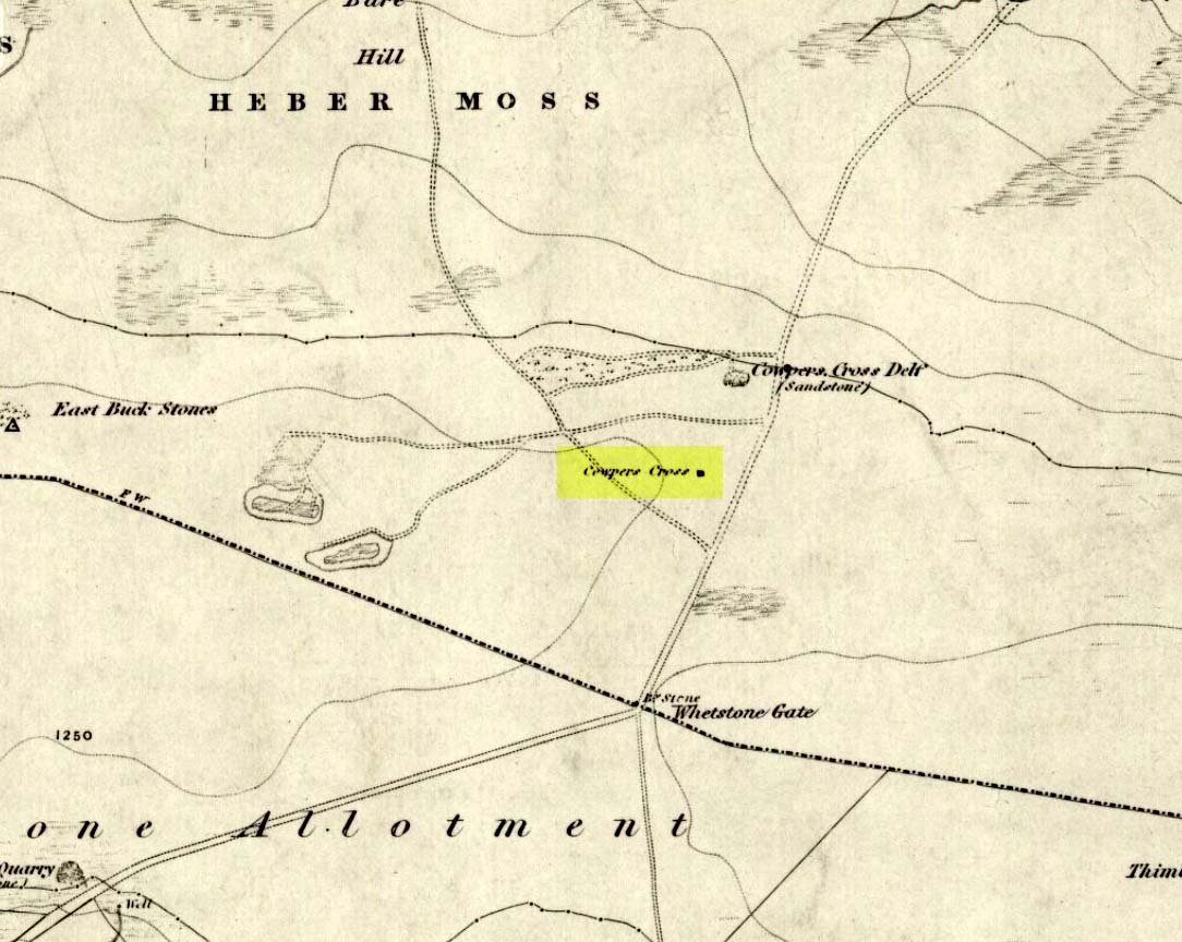
From Ilkley town, head up the road as if you’re going to White Wells but keep following the moorland road up towards Whetstone Gate and the TV masts on the very tops (you’ll have to walk the last half-mile). Shortly before you get them, you can’t miss this relic by the track-side on your right-hand side.
Archaeology & History
Possibly a christianised monolith, erected here in an attempt to divert local people away from the impressive Badger Stone where they may have held springtime gatherings. There used to be an old monolith laid on the ground a few yards away from the cross, which may have stood upright before the cross was erected. Also on the south-facing side of the cross were four cup-markings, indicating great age. These may also have been added when the cross was erected. (We know this occurred at other sites in the region, e.g., Churn Milk Joan, Midgley Moor, where such cup-marks were added sometime in the 15th or 16th century.) However, thanks to some idiotic halfwits in more recent years going up here and vandalizing Cowper’s Cross, the prehistoric cup-markings that were on this relic have been destroyed. The upright shaft of the cross that’s here now is a re-worked gatepost that replaced the old shaft with its authentic ‘pagan’ carvings.
1920s postcard of the Cross
But it’s had other bits of bad luck through the years. The site was struck by lightning many years back, splitting the stone in half, but has since been rebuilt and stands adjacent to its original position, right next to the old Roman road that crosses Ilkley Moor. Historian Allan Butterfield suggested this site to have originally been an old boundary markstone, christianised many centuries ago. The name ‘Cowper’ derives from the local Ilkley family of Cawper.
Those of you interested in the early christian history of these moors should also have a look at the little-known Black Knoll Cross, less than a mile south of here in the middle of Morton Moor.
Folklore
Folklore relates that markets were held at this old stone cross many years ago. This gives added weight to the idea that the nearby cup-and-ring marked Badger Stone, where markets were probably held around the time of the equinoxes, was the original site for such gatherings. Note that another site, the Reva Hill Cross, on the eastern side of this moor, has much the same history.
References:
Bennett, Paul, The Old Stones of Elmet, Capall Bann: Chieveley 2001.
Cowling, E.T., Rombald’s Way, William Walker: Otley 1946.
This place is one of the first things you see when roving the northern edge of Ilkley Moor. Tis the small white house, perched on the hillside, which you can reach via the old track bending round to it on the west side, or the steep footpath which goes roughly straight uphill from the road, just above Ilkley Town centre, up (both) Wells Walk or Wells Road. If you go just a few hundred yards up these roads, as the road bends and the moor opens up ahead, you’ll see the white building above you. But if you’re truly useless at finding your way about, ask anyone of them there locals…
Archaeology & History
The White Wells, Ilkley Moor
The White Wells have been described by countless writers over the centuries and attested as one of the great healing wells of the region. It was, without doubt, one of the most important water supplies to the indigenous Britons living on the moors here. One of their settlement sites is above the cliffs behind the modern position of the wells — though archaeological work has yet to be undertaken been. Cup-and-ring marked stones scatter the edge of the ridge right above where the waters originally appeared (a few hundred yards further up the slope on the hillside, just below the trees); and the folk-memory of our ancestors living here is found in several adjacent sites known by ‘fairy’ place-names.
But today it looks nothing like it would have done when the ancient people of the moors drank these waters, nor even when the Romans came here. For the white building which today houses the well was built around 1760 by the local Squire Middleton and originally contained three plunge baths in which folk would take the ‘cold water cure.’ (These were looked after by William Butler and his wife and were typically used by the gentry of the period, who it seems didn’t mind too much having to walk up the hillside to bathe in the “mellifluent, diaphanous, luminous waters.”)
Carved ‘celtic’ head, from which the water now emerges
The water in the house (you can go in and have a look), which now empties into a plunge pool, pours gently from the open mouth of a ‘celtic head’ – thought by some modern pagans to be ancient, but in fact is barely 200 years old. The water at White Wells originally emerged from the Earth several hundred yards further up the slope, above the present position of the house, much closer to the moor edge near the bottom of the steep slope where the pine trees cling, amidst rocks, moss and lichen. Here is where the original waters were first borne.
Long held as being curative, the first detailed description of the place was in Thomas Short’s (1734) magnum opus, where he said:
“Ichley-spaw springs out of the middle of a mountain, a mile high, and consists chiefly of lime stone and freestone. The water is very clear, brisk and sparkling; has no taste, colour nor smell different from the common water, is of the same weight. Its bason and course are of no other dye than that of a common spring. About thirty-five years ago, there were a house and a bath built, about a furlong below the original spring, which spring was brought down in stone-pipes. The first spring, near the top of the hill was very weak and small; this, very large and strong; whereby there appears to be a large mixture of other springs with this; since which time, it has fallen much sort of its former great success. Twenty yard above the drinking well (over which is built a small house of a yard square on the inside) they have cut thro’ an original spring of common water. There are several old lime-kilns a little above this. The water is first whitish, then blackish purple with solution of silver; it’s very clear, and has a purplish pellicle, with solution of sublimate; it was first white, then clear in the middle, and a white mucus at the sides and bottom of the glass, with solution of Sugar of Lead; very clear, with Oil of Tartar; whitish, with Spirit of Hartshorn; and the same as common water, with all the other trials. Five pints of this liquor exhaled left seven grains of sediment, the salt whereof dissolved in distilled water, turned solution of silver purple; was white with Spirit of Hartshorn: therefore tho’ this water is of the greatest esteem and repute of any in the north of England, in the King’s Evil and other old ulcers; yet it derives these effects neither from its fixt nor volatile parts; but wholly from the coldness and purity of the element, its drying nature from the lime-stone it washes, tho’ a great part of it comes from blue clay.”
In 1830, one Thomas Shaw said of the place,
“The water is, perhaps, for its purity, tenuity and coldness, the best qualified to be of utility for relaxed and sedantry habits of any water in this part of the country. It has frequently been analysed, but the decomposition always proved that it contains no medicinal quality. In my opinion, it is its purity and softness only, which makes if more efficacious, by passing sooner and to the utmost and finest limits of the circulation than any water known.”
But although many cures were claimed of the waters here, as Kathleen Denbigh (1981) wrote:
“According to a 1977 analysis, it is simply a clear, colourless spring water of moderate hardness, organically pure and free from metallic contamination and coliform organisms.” — i.e., it’s good clean water!
When the place gained a reputation as a spa, it was frequented by such notaries as Charles Darwin, Frederick Delius and Prof. David Baldwin. But even before this, in 1709, Dr Richard Richardson of Bradford—a reputable naturalist but also with considerable interest in ancient and occult matters—wrote that the site “has done very remarkable cures in scrofulous cases by bathing and drinking of it.”
Folklore
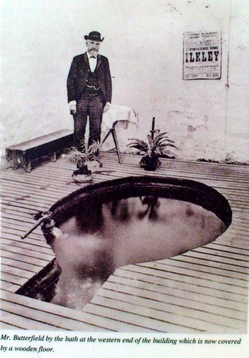
Old photo of Mr Butterfield, who saw fairies here
Popularly believed in local lore to have been a place held as sacred to the Romans, I’m of the opinion that the local ‘goddess’ Verbeia was resident here. A thought also mentioned by G.T. Oakley (1999) in his book on the subject.
Legend tells that the medicinal properties of the waters were first discovered hundreds of years ago when an old shepherd, walking over the moors, damaged his leg. Upon bathing it in the waters here, it soon healed.
In the Folklore Record of 1878 we find a fascinating tale about these waters, alleged to have happened to the old keeper of the place, told by a local man John Dobson, and which cannot go untold:
“William Butterfield…always opened the door first thing in the morning, and he did this without ever noticing anything out of the common until one beautiful, quiet, midsummer morning. As he ascended the brow of the hill he noticed rather particularly how the birds sang so sweetly, and cheerily, and vociferously, making the valley echo with the music of their voices. And in thinking it over afterwards he remembered noticing them, and considered this sign attributable to the after incident. As he drew near the wells he took out of his pocket the massive iron key, and placed it in the lock; but there was something “canny’ about it, and instead of the key lifting the lever it only turned round and round in the lock. He drew the key back to see that it was alright.and declared, “It was the same that he had on the previous night hung up behind his own door down at home.” Then he endeavored to push the door open, and no sooner did he push it slightly ajar than it was as quickly pushed back again. At last, with one supreme effort, he forced it perfectly open, and back it flew with a great bang! Then ‘whirr, whirr, whirr’, such a noise and sight! All over the water and dipping into it was a lot of little creatures, all dressed in green from head to foot, none of them more than eighteen inches high, and making a chatter and jabber thoroughly unintelligible. They seemed to be taking a bath, only they bathed with all their clothes on. Soon, however, one or two of them began to make off, bounding over the walls like squirrels. Finding they were all making ready for decamping, and wanting to have a word with them, he shouted at the top of his voice—indeed, he declared afterwards, he couldn’t find anything else to say or do—”Hallo there!” Then away the whole tribe went, helter skelter, toppling and tumbling, heads over heels, heels over heads, and all the while making a noise not unlike a disturbed nest of young partridges. The sight was so unusual that he declared he either couldn’t or daren’t attempt to rush after them. He stood as still and confounded, he said, as old Jeremiah Lister down there at Wheatley did, half a century previous, when a witch from Ilkley put an ash riddle upon the side of the River Wharfe, and sailed across in it to where he was standing.1 When the well had got quite clear of these strange beings he ran to the door and looked to see where they had fled, but nothing was to be seen. He ran back into the bath to see if they had left anything behind; but there was nothing; the water lay still and clear as he had left it on the previous night. He thought they might perhaps have left some of their clothing behind in their haste, but he could find none, and so he gave up looking, and commenced his usual routine of preparing the baths; not, however, without trotting to the door once or twice to see if they might be coming back; but he saw them no more.”
Along with sightings of ‘little people’, ghosts have been seen at the White Wells. It is thought that the strange apparition which presented itself to a householder here in 1982—the ghostly figure of a young girl, weeping at the water’s edge—was that of little Ann Harper who, in August 1793, at the age of nine, drowned in the well when bathing.
Earthlight (UFO) phenomena have also been reported here over the years—the most dramatic of which was alleged to have taken place at the top of the slope above the original source of the wells in 1989, when a police officer reported and photographed a “little green man” on the geological prominence just behind the wells. He went on to narrate a typical UFO ‘abduction’ event, but much of this was psychogenic and the mythic undertones echo precisely the medieval lore of abduction by faerie.
The Fortean researcher David Barclay found in his dowsing investigations here that there were spiral patterns all round the place. “At first these were in no order,” he wrote, “but through a period of over twenty visits to the place, I established markers which indicated the spiralling patterns of the energy” within the Earth immediately adjacent to the White Wells. These spirals were nearly always in a clockwise direction. In further studies here, he and I came to know a Mrs Elsie Hill, who had done some quite striking automatic drawings of the place. “In her pictures,” he wrote, “appear a prominence of spiral-forms and faerie creatures which, she believes, inhabit White Wells.”
Hmmmm…..
…to be continued…
References:
Bennett, Paul, The White Wells, Ilkley Moor, Heathen Earth: Keighley 2009.
Bogg, Edmund, Upper Wharfeland, James Miles: Leeds 1904.
Collyer, Robert & Turner, J. Horsfall, Ilkley, Ancient and Modern, William Walker: Otley 1885.
Denbigh, Kathleen, A Hundred British Spas, Spa Publications: London 1981.
Granville, A.B., Spas of England, Henry Colburn: London 1841.
Oakley, G.T., Verbeia: The Goddess ofWharfedale, Rooted Media: Leeds 1999.
Shaw, Thomas, The History of Wharfedale, Otley 1830.
Short, Thomas, The Natural, Experimental and Medicinal History of the Mineral Waters of Derbyshire, Lincolnshire and Yorkshire, privately printed: London 1724.
Speight, Harry, Upper Wharfedale, Elliott Stock: London 1900.
Whelan, Edna and Taylor, Ian, Yorkshire Holy Wells and Sacred Springs, Northern Lights: York 1989.
Various routes to this giant tomb, which happens to be a way off the roads (thankfully!). Probably the easiest way is from the Menston-side: up Moor Lane, turn left at the end, go 200 yards and take the track onto the moor. Just keep walking. If you hit the rock-outcrop nearly a mile on, you’ve gone past your target. Turn back for about 400 yards and walk (south) into the heather. You’re damn close!
Archaeology & History
Great Skirtful of Stones cairn looking east to Otley Chevin
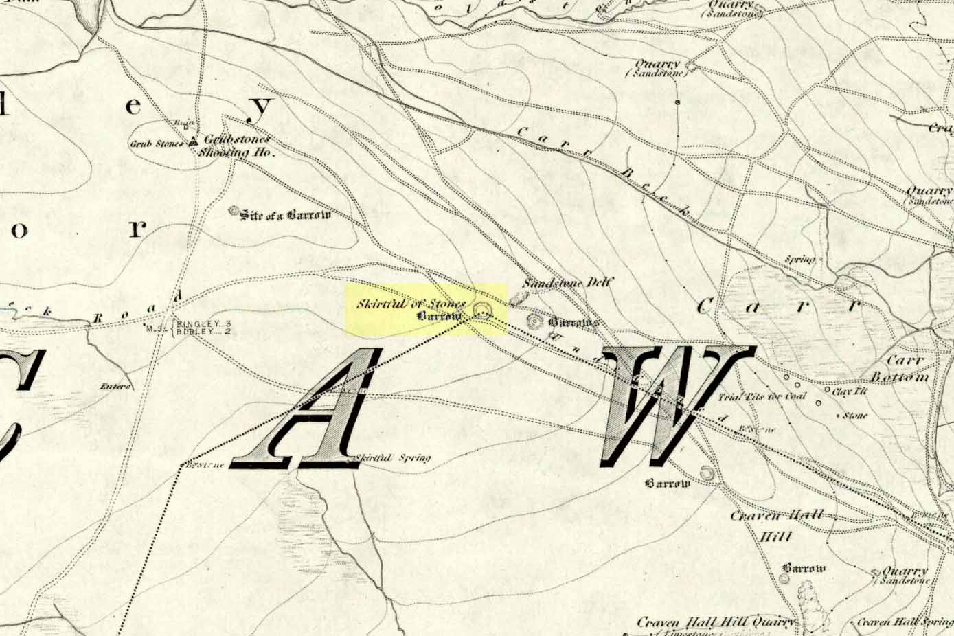
Due north of the Skirtful Spring water source, this is one of Ilkley Moor’s major prehistoric sites: ‘major’ for a number of reasons – not least of which is the size of the thing! Although getting somewhat overgrown these days as more of the heathlands encroach the mass of rocks that constitute the central ‘tomb’, it is still a formidable heap. Another reason this site is of importance is its position in the landscape: it can be seen as the peak or ‘nipple’ on the landscape from considerable distances north, south and east of here, rising up on the horizon and catching the eye from many miles away. This was obviously quite a deliberate function of the site when it was first constructed – thought to be in the Bronze or Iron Age period (sadly we have no decent excavation here to tell us just when it was made). Another reason for its importance is its position relative to a once huge prehistoric graveyard immediately east. And right next to it we also find a curious circular monument that has never been properly excavated, whose function is unknown. It is also the seeming focal point of at least one, though possibly three prehistoric trackways: one of which goes right past it, though swerves on its southern edge quite deliberately so as to not touch the monument. This trackway appears to have been a ceremonial ‘road of the dead,’ along which our ancestors were carried, resting for some reason at the nearby Roms Law, or Grubstones Circle, a few hundred yards to the west.
Wrongly ascribed as a “round barrow” by archaeologist Tim Darvill (1988), the Great Skirtful cairn was named in boundary changes made in 1733, where one Richard Barret of Hawksworth told that the site was “never heard go by any other name than Skirtfull of Stones.”
In 1901 there was an article in the local ‘Shipley Express‘ newspaper — and repeated in Mr Laurence’s (1991) fine History of Menston and Hawksworth — which gave the following details:
“Mr Turner led the way across Burley Moor to the Great Skirtful of Stones, a huge cairn of small boulders, nearly a hundred tons on a heap, although for centuries loads have been taken away to mend the trackways across the moor… The centre of the cairn is now hollow, as it was explored many years ago, and from the middle human bones were taken and submitted to Canon Greenwell and other archaeologists” – though I have found little in Greenwell’s works that adequately describe the finds here. Near the centre of the giant cairn is a large stone, of more recent centuries, which once stood upright and upon which is etched the words, “This is Rumbles Law.” The Shipley Express article goes on: “Mr Turner explained that ‘law’ was always used in the British sense for a hill, and Rumbles Hill, or cairn, was a conspicuous boundary mark for many centuries. He had found in the Burley Manor Rolls, two centuries back, that on Rogation Day, when the boundaries were beaten by the inhabitants, they met on this hill, and describing their boundaries, they concluded the nominy by joining in the words, “This is Rumbles Law.””
Great Skirtful on 1851 map
Several other giant cairns like this used to be visible on the moors, but over the years poor archaeological management has led to their gradual decline (and in editing this site profile in 2016, have to report that poor archaeological and moorland management is eating into and gradually diminishing this monument to this day). We still have the Great Skirtful’s little brother, the Little Skirtful of Stones, a half-mile north of here. The very depleted remains of the once-huge Nixon’s Station giant cairn can still be seen (just!) at the very top of Ilkley Moor 1½ miles (2.65km) west.* And we have the pairing of the giant round cairn and long cairn a few miles west on Bradley Moor, near Skipton. The tradition of such giant tombs on these hills was obviously an important one to our ancestors.
Folklore
We find a curious entry in the diaries of the Leeds historian Ralph Thoresby, in the year 1702, which seems to describe the Great Skirtful of Stones, adding a rather odd bit of folklore. (if it isn’t the Great Skirtful, we’re at a loss to account for the place described.) Mr Thoresby told how he and Sir Walter Hawksworth went for a walk on Hawksworth’s land and said how,
“he showed us a monumental heap of stones, in memory of three Scotch boys slain there by lightning, in his grandfather’s, Sir Richard Hawksworth’s time, as an old man attested to Sir Walter, who being then twelve years of age helped to lead the stones.”
As far as I’m aware, this old story of the three Scottish boys is described nowhere else.
Like many giant cairns, the Great Skirtful has a familiar creation myth to account for its appearance. In one version we hear that it was made when the local giant, Rombald (who lived on this moor) and his un-named wife were quarrelling and she dropped a few stones she was carrying in her apron. A variation swaps Rombald’s wife with the devil, who also, carelessly, let the mass of stones drop from his own apron to create the ancient cairn we still see today.
According to Jessica Lofthouse’s North Country Folklore (1976), a Norse giant by the name of Rawmr, “fell fighting against the Britons of Elmet and is buried, they say, on Hawksworth Moor” – i.e., the southeastern section of Rombald’s Moor, very probably at the Great Skirtful of Stones. I’ve yet to explore the history and etymology of the name Rawmr…
References:
Bennett, Paul, The Old Stones of Elmet, Capall Bann: Chieveley 2001.
Cowling, Eric T., Rombald’s Way, William Walker: Otley 1946.
Darvill, Timothy, Ancient Britain, AA: Basingstoke 1988.
Laurence, Alastair, A History of Menston and Hawksworth, Smith Settle: Otley 1991.
* Whoever is/was supposed to be responsible for the care of the Nixon’s Station giant cairn monument should be taken to task as it’s been virtually obliterated since when I first came here 30 years ago. Which useless local archaeologist and/or council official is responsible for its destruction? Who allowed it to happen? Why are Ilkley Moor’s prehistoric monument’s being so badly looked after by those who are paid to ensure their maintenance? Are their heads up their arses, in the sand, or—don’t tell me—the prawn sandwiches are to blame!?
Not hard to locate. From Colne head up to Foulridge via the skipton Road and as you get to the middle of the town ask find the cenotaph just off the main road.
Archaeology & History
The Maiden or Tailor’s Cross, Foulridge
The Maiden or Tailor’s Cross has at least two old traditions attached to the site, which local historians think originate from the Civil War period. The first tells of a Royalist tailor who – sensibly – refused to make uniforms for Oliver Cromwell’s traitorous soldiers; but as a result, the poor tailor was shot by the troops and the remains of his body were placed over the old stone cross as a warning to his fellow workers. If you look closely on the cross you can see a crude carving of what looks like a pair of scissors or shears, and it is this carved symbol which has seemingly given birth to the legend of the tailor. There may, of course, be some truth in the story; but the carved shears is more likely an old Masonic carving – though quite who did it and when isn’t known.
The other legend is the one which apparently gave birth to the title of the Maiden’s Cross. It tells of a certain Margaret Burnard whose husband went into battle (on the side of the treacherous Cromwell), but who agreed before he set out that she should wait for him for to return by the side of the old cross; and this she did each and every day, waiting for her husband, Robert, to come back from the Civil War. But he was one of the many who died in the Battle of Marston Moor. However, Margaret refused to accept his death and returned to the cross each evening to their agreed meeting place. The story goes that Margaret herself herself was eventually killed by Royalist soldiers – and her body was buried at the cross where she had so often waited in vain.
It seems likely that this old cross originally replaced an old ‘heathen’ site in Foulridge. Several such spots were known here, though virtually nothing now remains. But notices of these sites will appear on TNA in the near future.
References:
Oldland, F., The Story of Foulridge, PHCL: Pendle 1990.
From Ilkley, head up the road towards White Wells and keep going along the road. Shortly before the road becomes a dirt-track, just over a small stone bridge with gorse all around, there’s a noticeable footpath that runs west onto the moors, going roughly parallel to the wealthy houses by the moorside. Keep going along this footpath and you’ll hit the recently unneeded modern creation of a large sandy trackway (and excessive litter that it’s created) that takes you straight to the curious railings stuck upon some rocks a quarter-mile away. That’s where you’re going!
Archaeology & History
This famous carving was first described as a ‘swastika’ by a Mr J. Thornton Dale around 1880 – and the name seemed to catch on damn quick! The stone had become established with this title at the end of that decade, and seemed immortalized with the name when J. Horsfall Turner wrote about it in the very popular history book he co-authored with the reverend Collyer in Ilkley Ancient and Modern. (1885) By then, comparisons had already been drawn with the acknowledged swastika symbol in Tossene, Sweden, and by the time Harry Speight described it in his colossal Upper Wharfedale (1900), other near-identical European swastika carvings had been found in Valcamonica, northern Italy. (though these lacked the ‘tail’ found on Ilkley’s carving)
J.R. Allen’s drawing of Swastika StoneEric Cowling’s sketch of the carving
Earlier images of the swastika symbol can be found in most continents, but the earliest known example appears to be the paleolithic swastika carvings from the Ukraine, etched on pieces of ivory and dating from between 18,000-15,000 BC. Some swastikas have been found carved on mammoth tusks!
Invariably in modern history it is its mythic association of the swastika to certain political imbeciles which troubles many people, but this needs to be set into a much more ancient historical context. The symbol ostensibly relates to sacred notions of the cosmos in all the non-literate cultures where it appears. Numerous surveys by comparative religious scholars isolated the nature of the design many years ago. The Leeds Buddhist, Steve Hart, said that Ilkley’s Swastika Stone:
“to a Buddhist should be a sonorous gatha (a sutra or verse), a plenitude of transcendental boddhisattvic vision. The swirling wheel of the four arms suggests the four realms as experienced by Jains, upanishadic sages and ancient Buddists. They ARE samsara. The samsara is resolved into the nirvana at the hub. The four realms are the human realm, god realm, hell realm and the nature realm. There are no clear delineated demarcations between these realms. All interpenetrate.”
(Images of the popularised ‘modern’ swastika – a huge misnomer – can be found on several church bells in Yorkshire, where they were used as charms to protect against lightning, following in the mythic fashion of Thor. These swastikas date from the 15th century.)
Evan Hadingham’s rubbing of the carving
I first saw this carving when I was 10-years old and it had one helluvan effect on me! I stood and stared at it (or rather gazed, without thought…) for some length of time, knowing that I’d seen this somewhere before* and that it had some considerable importance – though about what, I knew not! The cups in the design align north-south and east-west. The northern line points directly at Simon’s Seat on the northern skyline. The eastern axis points directly at Almscliffe Crag, above which the equinox sun seems to rise from here.
For the real alignment fanatics, check out the alignment from Twelve Apostles to here: on the date of the last major lunar standstill (occurrent every 18.6 years), the moon set over the cairn at Lanshaw Lad. It wasn’t until I got home and checked the extension of this moonset line, that I realised if you follow it further along the course, you hit the Swastika Stone bang on! Though this is probably just a coincidence (we do have hundreds of cup-and-rings on these moors, so it’s bound to hit one or more of them).
The Swastika in 1930, with info-board
In this Swastika Stone, the curious single ‘outlying’ cup-and-ring at the edge of the four spiralling arms is very probably the point from which the four-arms originated and not the other way round. In traditional cultures and early cosmogenic patterns the world over, the cosmos itself emerged from the ’round’, the singular, the point, or uroboros — and this is what this Swastika Stone appears to represent here: the cosmos emerging from the singularity, giving birth to the world and the four cardinal points. Such an element is a simple one and is found in Creation myths the world over. (For those of you who aint into using psychedelics at sites, a good overview of this idea is in Erich Neumann’s Origins & History of Consciousness [although there’s no reference to this symbol] and which should be read by anyone pretending an interest in the nature of the archaic mind. It’s a good work on the psychology of the Dreamtime.)
As some local Ilkley folk are probably aware, a copy of the Swastika Stone carving was executed in the latter-half of the 19th century, probably by a local chap called Ambrose Collins, not far from the original swastika at the edge of the woodland. Some images and a brief history of this copied swastika and associated cup-markings will be published in due course on the Rombalds Moor Project website.
Other important cup-and-ring petroglyphs that are worth visiting on the moor with unique carved symbols in them include the Hanging Stones, the Idol Stone, Haystack Rock, Badger Stone and many many more.
Note:
A fella who used the pseudonym of ‘Pad’ suggests that the carving is only a few centuries old, and compares it to other much more recent etchings on these moors, where the erosion has been of no greater or lesser force. The suggestion has been made about other carvings on these moors and whilst I have an open mind about this, if this is the case, we would have to relate the same reasoning to countless other carving on these hills. In which case, a great deal of cup-and-ring art would have to be redesignated as medieval in nature.
References:
Bennett, Paul, The Old Stones of Elmet, Capall Bann: Milverton 2001.
Boughey, Keith & Vickerman, E.A., Prehistoric Rock Art of the West Riding, WYAS: Wakefield 2003.
Collyer, Robert & Turner, J. Horsfall, Ilkley, Ancient and Modern, William Walker: Otley 1885.
Cowling, Eric T., Rombald’s Way, William Walker: Otley 1946.
Hadingham, Evan, Ancient Carvings in Britain, Garnstone: London 1974.
Hedges, John, The Carved Rocks on Rombalds Moor, WYMCC: Wakefield 1986.
Pennick, Nigel, The Swastika, Bar Hill: Cambridge 1980.
Speight, Harry, Upper Wharfedale, Elliott Stock: London 1900.
Wilson, Thomas, The Swastika – The Earliest Known Symbol and its Migrations, Smithsonian: Washington 1896.
* although I’d never seen the carving before, I had of course seen its archetypal manifestation in the shapes in Nature: spiral galazies, polar rotation (I was a budding astronomer as a kid!), hair growth from the crown, petals, swirling clouds, etc, etc. The Swastika, as we know, is representative of the creative spark itself: the life-essence, emerging from the centre and manifesting itself in the four worlds, which are its emergent arms.
Links:
Reclaim the Swastika – A fine website which is into doing just what it says on the tin!
There are many ways of reaching the Apostles, but I’ll stick to describing the two commonest routes for those of you who wanna find it. The first is the route out of Ilkley. Get to the White Wells (white building nestled on t’ edge of t’ moors) – ask a local if you don’t know where it is. From here follow the path up past the Wells, up the stepped-cliffs, and once on top where there’s a crossing of paths, keep straight forward onto the moors for about a mile. Once you’re on the very top of the moors, keep your eyes peeled to the left of the footpath and you’ll see it! From the other, southern-side of the moor, start from Dick Hudson’s pub, cross the road and go up the footpath onto the moor. Now, just keep walking for a mile or so, until the circle appears on the right-hand side of the footpath right near the very top of the route.
Apostles, looking E (photo by Sarah Walker)
You can try other route is easier if you’re not quite as fit. Drive up to the top of old Roman Road which crosses the moors and when you reach the gate near the radio masts, take the footpath east. Walk straight on for about a mile until the path veers to the right (southeast). You’re now at the rock known as the Ashlar Chair. From here, take the left-hand path and walk on for a few hundred yards till you hit the main footpath. Once on the path, turn right (south) and about 100 yards away the Apostles is just to the side. Y’ can’t really miss it.
Archaeology & History
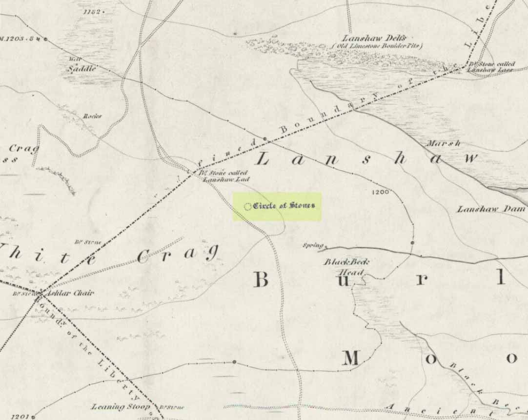
Apostles on 1851 map
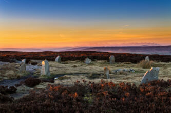
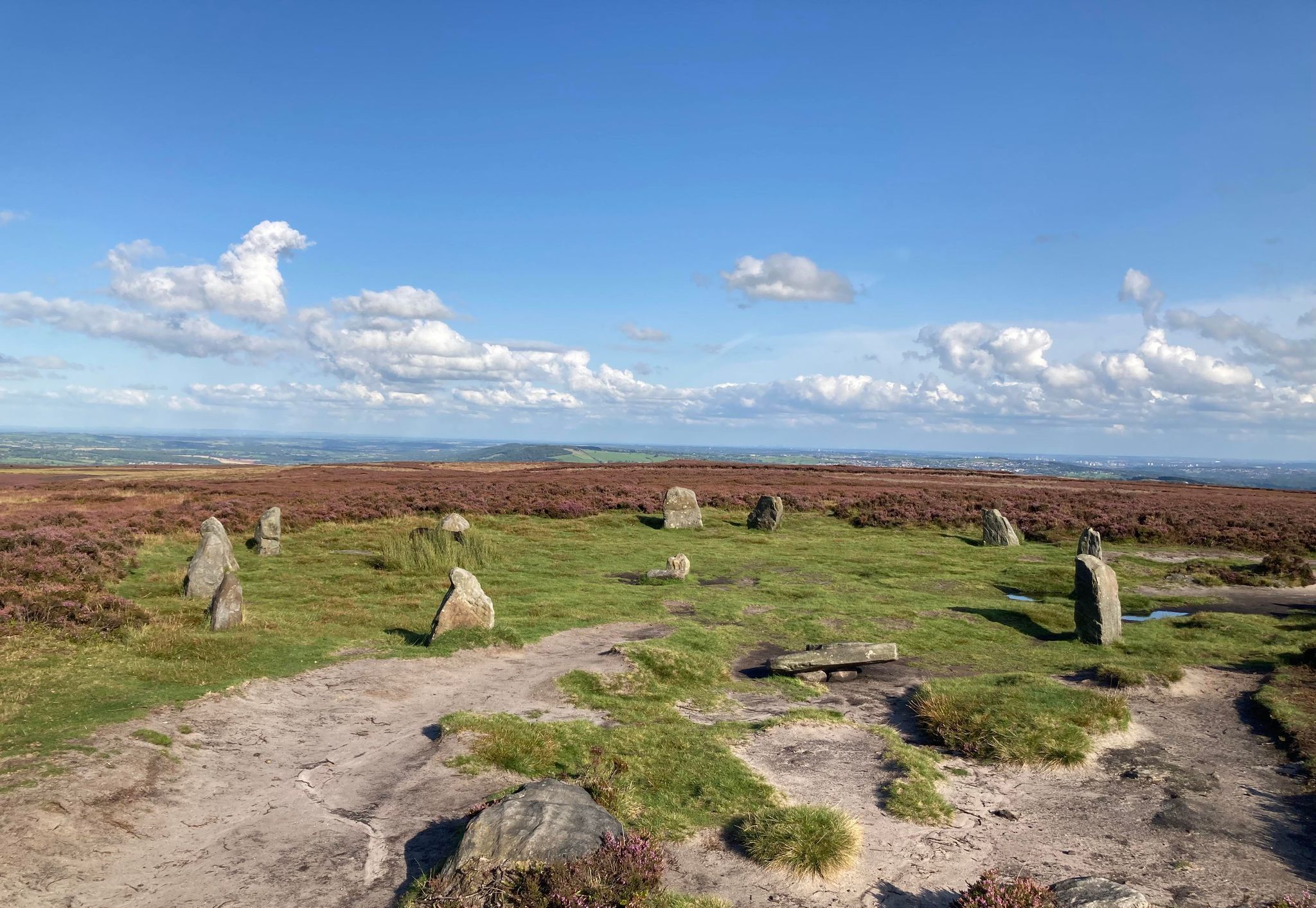
First highlighted on the 1851 Ordnance Survey map as a “Circle of Stones” close to “The Stone called Lanshaw Lad”, the Twelve Apostles stone circle is one of the highest of all ancient monuments upon Rombald’s Moor, 1264 feet above sea level. Only a small prehistoric enclosure (recently discovered) and the defamed giant cairn at the very top of the moors, known in previous centuries as ‘Nixon’s Station’—described in 1885 as being a hundred-and-seventy-five yards in circumference, then in 1900 as a hundred-and-fifty-yards—are higher. It is by no means a spectacular stone circle. Certainly in comparison to places like Castlerigg, Avebury, Callanish or the Argyll stones, it fades into insignificance!
In earlier times the circle possessed such names as the ‘Druid’s Chair’ and the ‘Druidical Dial Circle’—the first of which implying it to have been a place of ritual inauguration, and the latter a folk remnant of it being a site where the solar and lunar year would be recorded. Indeed, as early as 1850, antiquarian and rambler James Wardell described this site as “the astronomical circle,” after local folklore about the site being used as such. Today, such ‘folklore’ has entered into being academically acceptable in many quarters; though the significance of such alignments is still hotly debated.
Earliest plan of the Apostles (J.N.M. Colls 1846)
What greets us today would have been, several thousand years ago, planned and prepared sometime before the stones were erected close to the crossing of the two most important trackways crossing these moors, marking “an event of some importance.” These trackways face the four cardinal points, or airts, and one of them is believed by archaeologists to have been a major prehistoric trade-route that crossed the mid-Pennines. Around 1800 BC – the academics guess – the ring of stones took form.
The all-but-forgotten Black Beck Well (SE 1276 4494), two hundred yards south of the Twelve Apostles, was an important water-hole for our prehistoric traders and travellers and may well have had some function relative to this megalithic ring. Certainly, the well was being used by traders late into the 19th century.
According to archaeologist Arthur Raistrick, the Twelve Apostles originally consisted of at least twenty upright stones with a solitary monolith at its centre. It was this central stone which, not unsurprisingly, gave it the tradition of being a druidical dial circle. This is probably not without foundation as the centre-stone may well have acted as some sort of shadow-marker, or simply the point from where solar, lunar and perhaps stellar observations were made. When Raistrick first came here though, he reported that only three of the stones were standing. A few years later when Cowling described the site, he said that all of the stones “are now overthrown.” This is, sadly, something we have to constantly deal with. In Raistrick’s further description of the Apostles, he wrote:
“The circles of stones is erected on a bank of earth and small stones, as nearly circular as can be measured, and fifty-two feet (15.9m) in diameter, centre to centre of bank. The bank is about four feet wide and in places about two feet above the surrounding ground level.”
Local news report from 1976
Cowling’s measurements told it to be fifty-eight feet across. Sadly, traces of the raised embankment that once enclosed the entire circle can now only be seen in the undergrowth on the south-side of the ring. When the heather is low you can make out an arc of raised rubble about 12 inches high and no more than a yard across, running for some 20 yards along the edge of the circle. In the 1960s all of the standing stones in this circle had been knocked over and were left ruinous in deep heather. The local authority council and regional archaeologist of Ilkley and district were (and still are) negligent of their duties to look after the ancient monument on these moors. Thankfully a group of local heathens took it upon themselves to stand the stones back upright and restore the circle to roughly how it looks today. Local pagans and amateurs have looked after the Apostles, restoring it when vandalized, from the ’70s onwards. In all honesty — and the same still applies to this day — if we’d have waited for the local archaeologists to get off their arses to restore the Twelve Apostles, it would have been destroyed long ago.
In more recent times, the site has been ascribed as “a circular ceremonial monument”, which I think is appropriate, although no burial or ritual remains have ever been found here. As we shall see however, this description is most fitting when put into context with the wider landscape.
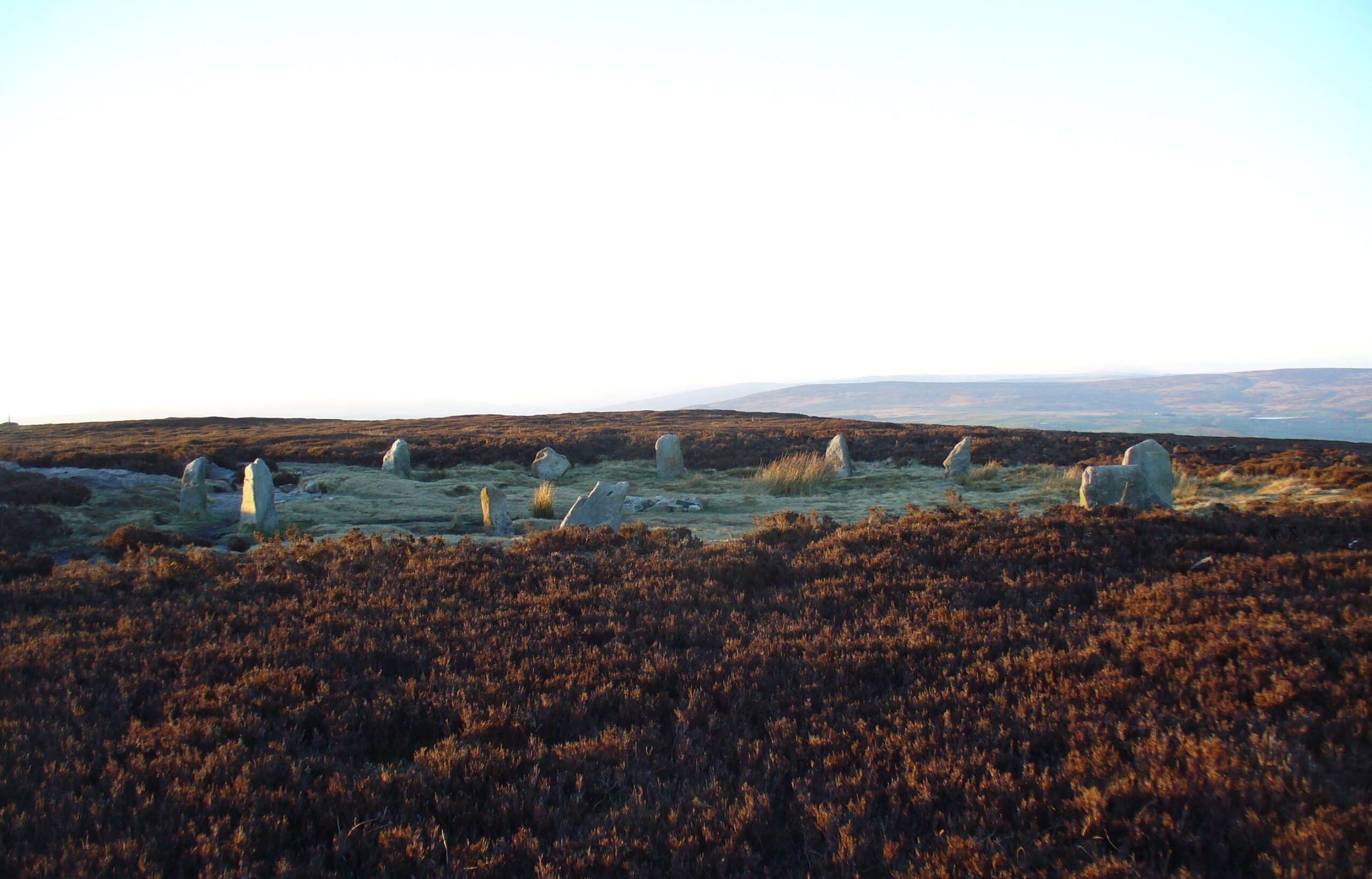
Twelve Apostles in winter snow (photo by Richard Stroud)
Visitors to the Twelve Apostles should be aware (if they weren’t already) that the circle they see today bears little resemblance to the place when it was first constructed around four thousand years ago. The scattered woodland which covered most of these now-barren moorland heights have long since gone and the stones have been moved and overthrown so many times that it would be very difficult indeed to gain an accurate picture of what the circle originally looked like. But this should not deter our investigations.
We should also be very cautious in making assumptions about the nature of pre-christian events that occurred here. Although modern pagans frequent this place at set times of the year, their activities have little, if any bearing, on the rites of our ancestors (despite what some of them might tell you!). However, scattered historical accounts do tell us about the activities of more obscure events hereabouts.
Looking to the north
At the nearby Roms Law or Grubstones Circle (SE 1363 4473), records tell us how local people gathered on Rogation Day (a pre-christian agricultural ritual festivity, closely related to Beltane). A central stone—now moved into the huge Great Skirtful of Stones tomb a few hundred yards east—stood at its centre and an orator spoke to the people from here, ending with the words, “This is Rumbles Law!” Although we have no records of such actions at Twelve Apostles, the central stone which once stood here may have been a focus for such orations. The tribal leader and tribal shaman would have enacted this in ancient days. However, we do know from folklore records that the fabled Pendle witches and the lesser-known witches of Fewston (in the beautiful Washburn Valley a few miles to the north) met together on top of these hills, and the Twelve Apostles is a good contender as one of their likely assembly points.
Any verifiable history of Twelve Apostles is, as we can see, somewhat scarce, although in recent years observations from the site itself at select times of the year (solstices, equinoxes, etc.) have brought us a greater wealth of information.
As every good geomancer knows, literal knowledge about a place in the landscape is limited: how we look at such ritual sites determines, to a very great degree, how much we receive. If we look at the site as an astronomer, we will see the place through astroarchaeological eyes; if we look at it as an architect, mathematical formulae will overlay the complex; or if we see it as a New Ager, angels and auras will appear. With this in mind it is imperative we look at such places with a non-ethnocentric perspective. No easy thing.
Curious Alignments
Although dispossessed of its original spirit, it does not distract us from perceiving some elements of what appears to be one original function of the site. Its position in the landscape was obviously of grand geomantic importance and, having watched the motion of both sun and moon from this quiet ring of stones (the lunar standstills are recorded here), one is impressed, if not by its feeling, certainly by its siting relative to other arcane monuments. Those who know the Twelve Apostles and have visited it on a fine clear day will know what I mean. The view is considerable, peering far into the uplands of the Yorkshire Dales, looking upon a great panoramic circle nearly eighty miles across. I remember seeing this for the first time as a child and was entranced by it. So why had they placed this circle where they had…?
Looking at the Twelve Apostles on a large-scale Ordnance Survey map (6-inch to the mile, or 1:10,000)—as most linear-thinkers do nowadays—we see a remarkable geometric image unfold before our eyes. Running straight eastwards 1180 yards away (1.08km) we reach the Grubstones circle. From the Apostles again, go straight north for another 1180 yards (1.08km) and you reach the ruins of the Backstone Circle (SE 1261 4613). Between these three circles we find a perfect isosceles triangle. But this isn’t the end of it: the longer axis connecting Grubstones to Backstone is some nineteen-hundred yards long (1.731km) and at the mid-point along this line, the now-recumbent Lanshaw Lass boundary stone once stood. Intriguingly, if we stand at Twelve Apostles for the Beltane sunrise (May day), we would see its golden orb rising on the far-eastern horizon right above our Lanshaw Lass.
This all may, of course, be coincidental. Our megalithic ancestors surely knew nothing of isosceles triangles and such stuff…
Full moonset at Major Lunar Standstill from 12 Apostles
Other astronomical alignments are perhaps not as contentious. In 1989 when the moon rose at its maximum northern point on the horizon (which occurs every 18.6 years and is known as the Major Lunar Standstill), it was photographed setting on the north-western horizon behind the old cairn which once stood just 130 yards away to the northwest, behind which stands the old boundary stone of Lanshaw Lad (this cairn was recently destroyed by some stupid halfwits from Ilkley). This alignment, if transposed onto a map and extended further, eventually reaches a quite remarkable ancient carving known as the Swastika Stone (SE 0956 4695) more than two miles away.
This alignment may again be coincidental as there are so many prehistoric sites upon these moors. Indeed, it seems that it would be hard not to find alignments up here! And although not all stone circles have astronomical systems encoded within them, studies show that many of them do.
The Summer Solstice Alignment
One very curious and probable alignment at the Apostles is the midsummer sunrise. It is celebrated every summer here by local folk who have been visiting the place, in recent years at least, for the last thirty years, despite the contorted attempts by the Church to suppress its natural celebration. In recent years the number of people visiting Twelve Apostles at midsummer has steadily increased; so much so that people are now scattering the moors in their hundreds to other sites. For many years I ambled my way up to this old ring of stones and waited for the sun to rise at summer solstice. After a few years the question of “Where exactly does it rise?” on this longest of days intrigued my teenage mind, but I had to wait a few more years until the morning air was clear enough to see the distant skyline…
Then, on the morning of the summer solstice in the mid-1980s, whilst the people around me were drumming, cheering, chanting and silencing themselves as the giant fireball rose once more from its daily horizon, I stood gazing, not at the sun, but at the very land beneath where it rose on that longest of days. And what I saw stunned me!
More than thirty-five miles (53km) northeast from the Twelve Apostles, the faint etching of a great white horse scarred the distant landscape exactly beneath where the sun rose on this longest of days. I must admit, I was metaphorically kicked in the neurological bollocks by this! If my eyesight wasn’t truly impaired by a night of no sleep, the far distant solar indicator I could see was the White Horse of Kilburn (SE 5142 8129)…
…And white horses, as is known in folklore, are potent symbols of the sun.
The real screwball with this sunrise indicator lies in the fact that Kilburn’s white horse was etched into the hillside only in the middle of the 19th century! It was cut into the slopes by a local man called Thomas Taylor. He had visited the magnificent prehistoric white horse at Uffington in Oxfordshire, plus others in the Vale of the White Horse, and was so impressed by them that he decided to make one in his own back yard, so to speak. After considerable effort and with the help of more than thirty local men, the steep slopes northwest of Kilburn had its own Epona: 314 feet long and 278 feet high. Said by one writer to be “visible for twenty miles” and another that it “could be seen up to seventy miles away”—figures that need drastically revising!
Despite the revelation that the midsummer sunrise from Twelve Apostles aligns with the White Horse of Kilburn, it was obvious that no arcane relationship—and hence no authentic mythic virtue—was possible here. The fact that some four thousand years separate the construction of both monuments precludes any valid connection between them.
This aside, I asked a research of friend, Graeme Chappell, to run through the possible astroarchaeology from Apostles to Kilburn in order to ascertain the validity, or otherwise, of this seemingly incredulous alignment. Lo and behold, in 1857 (when the Kilburn horse was completed), the “sun would have risen when it was over the white horse, but only just.” So I began putting this long distance alignment down to nothing more than a wonderful visual coincidence—until Graeme pointed out a much more curious astronomical folk remnant…
Around 1700 BCE, close to the time when Twelve Apostles was built, observers standing at the circle would watch the midsummer sunrise exactly over White Mare Crag. This wouldn’t seem that curious were it not for the folklore of these distant crags, themselves deeply symbolic of the sun.
The renowned Victorian antiquarian and folklorist, Edmund Bogg, wrote extensively about the curious legends that abound in and around the Kilburn area—several of which surround the great cliffs of the White Mare (locally known as Wisson Cliff in times past). Tradition tells that a white horse was once visible in the hillside here. Bogg told that it received its name from this horse, whose shape was visible in the shape of the huge rocky crags. At the bottom of the cliffs the faerie folk were said to live. Also here is Gormire Lake—bottomless according to folklore and apparently the abode of a sunken village, though history records (and geology) make this unlikely, so we must seek elsewhere for an explanation to such a tale. The waters of this lake fall into a small crevice at its edge and, so legend tells, these then flow uphill until eventually re-emerging at a well at Cold Kirkby village a mile to the east in the direction of the setting sun. These tales in themselves are intriguing relics of shamanism whose nature lies beyond the scope of this enquiry.
One folktale tells of a local ‘witch’ who was chased over the local moorland (by who or what isn’t remembered). She eventually reached the edge of White Mare Crag cliffs where she carried on running and jumped, landing in the waters of Gormire Lake beneath where it was thought she would drown. But, following the flow of water underground, the tale tells how she eventually re-appeared nine miles away out of an old (unnamed) well. An equally curious piece of lore tells of a goose that was dropped into the same crevice the witch went into after it had apparently dried-up, only to emerge, without any feathers, twelve miles away to the east at Kirkbymoorside.
But one tale in particular appears, to me at least, to have considerable relevance to our midsummer sunrise from the Twelve Apostles…
A long time ago an abbot from Rievaulx Abbey was in possession of a pure white horse, said to be as quick and nimble as any horse in the region. The abbot met up with a local landowner, Sir Harry Scriven, who also owned a horse of great repute – this time jet black, called Nightwind – and he challenged him to a race across Hambleton Moors (just above White Mare Crags). Sir Harry accepted, but the abbot insisted they swapped horses so that he could ride Nightwind and Harry was on the white steed. They took off, racing fast over the high moors until they reached the edge of White Mare Crags but, instead of stopping, the abbot continued galloping with Sir Harry following until they each plunged over the edge of the high cliffs. Legend tells that as Sir Harry fell to his inevitable death, the white horse which he rode dissolved into thin air and, as he looked across at his own horse Nightwind, looked at the abbot who turned into the devil. As Cooper points out, “the winged horse is the sun…as is also the white horse,” and as the horse in this legend “dissolved into thin air” as it went west over the Crags, could this be an old symbolic tale of the setting sun dissolving as it sets over the far horizon to the west? The black horse which remains, Nightwind: is this not the dark night which naturally follows?
We might never know, but it certainly makes sense of the tale. Especially when seen in relation to the summer solstice alignment from the Apostles. And if there was any possible commemoration of this line from White Mare Crags, the dark horse, Nightwind, would be the triumphant one, as the alignment into the far southwest from here to Twelve Apostles records the shortest night of the year: the winter solstice. Intriguing stuff!
But this primary midsummer alignment from Twelve Apostles gets even more curious…
Although books and magazine articles detailing ‘leys’ are numerous, they are, on the whole, full of lines that exist simply in the mind of their creators. Knowing these non-existent ‘old bent tracks’ — as us Yorkshire folk have come to call them! — are ammunition for trivialising the subject, precision is extremely important. It is obvious in this alignment however, that we are looking plain and simply at an astronomical line—not a ley. But, in good old fashioned ley-hunter style, I decided to get out the Ordnance Survey maps—2½-inch-to- the-mile scale—and check the cartographic nature of the line for myself. It took some doing! But its outcome threw up yet more bizarre finds, bending the parameters of Jungian synchronicity, never mind geodelic science!
As the illustration here shows, the line passes an old stone in the village of Askwith. A little further on we pass what Eric Cowling called ‘The Old Man of Snowden’—a squat standing stone close to the crossroads which appears to have been destroyed. Here too is the Grey Stone: an ancient boundary marker scared with intricate cup-and-ring designs. Although we pass one or two other fascinating spots where good folklore and history can be had—such as the moot points of Sword Point and Jack Hill—things don’t really start getting too interesting until we pass Nidd Church. (SE 3013 6081) “In the churchyard,” wrote Arthur Mee, “is the shaft of a cross about 600 years old, but it is said that the story of the village goes back twice as far, and that a great church council met over 1000 years ago.” This is more than likely, for just beyond is a place called Temple Yarmer where, as Harry Speight reminded us, once stood “an immense menhir or standing monolith.” Folklore told it to have been part of a now lost stone circle.
A little further on we pass by a few old boundary stones (SE 3160 6219; SE 3568 6578), but these will have nothing to do with our midsummer alignment. Not until we pass by the gigantic Devil’s Arrows at Boroughbridge (SE 3912 6650) do things begin getting a little bizarre. Although just three huge monoliths remains today, we know that least five of them were standing in the 15th century. It is very probable that more standing stones were in the original complex and our solar line may have crossed part of it. More certain are we of the midsummer’s day horse-festival that has been held here for many centuries. Known as the Barnaby Fair, recent years have seen the event almost vanish into history. But the motif of horses and midsummer here is intriguing. Nearby, at Kirkby Hill – over which our solar line crosses – is a spot known as the Fairy Hill and where, at midsummer, the little-people were wont to play in the early hours.
Continuing further and getting ever-closer to the White Horse which stands out from the Apostles, we reach the North Yorkshire village of Sessay. Here once lived a great one-eyed giant, said by folklore to be one helluva nasty dood – but this is just the Church demonising something it refused to try understanding. (In the neighbouring towns and villages of Topcliffe, Dalton and Pilmoor are other giant legends. It would be interesting to find the archaic roots of this geographical cluster.)
Next we reach the village of Kilburn itself. And here, every midsummer as far back as records can go, we have another horse festival. The activities here have truly heathen origins, comprising in parts to a great feast over the midsummer days. During this a procession itself is made by the villagers to the White Horse. We also have the figure of an androgynous ‘Lady Mayoress’ who runs through the streets receiving kisses from other ladies.
The final point on our journey along this midsummer line is the White Horse itself, whose visibility from Twelve Apostles started this journey in the first place.
The truly curious ingredients in this line is the coincidence (?) of midsummer fairs and horses as we travel along it. One wonders if there’s some sort of Cosmic Joker sat behind it all, rubbing its hands gleefully, waiting for the crazy speculators or New-Age dreamers to proclaim a Divine Rule or something similar. Stranger things have happened…
…Like the midwinter alignment from Twelve Apostles…
From our humble stone circle we trek out, south-east this time, first passing the Black Beck Well [SE 1276 4495] and then an ancient boundary stone [SE 1357 4430], before reaching Odda’s Hill. Slightly past here and below Hawksworth Hall is the Alder’s Well [SE 1671 4168] where a ceremonial procession used to be performed starting at the Hall—but I have been unable to establish what time of year this occurred. But, just a little further on, our midwinter line comes to the Hawk Stone [SE 1792 4099] where, “legend tells that a man on horseback leapt from the top of the Hawk Stone and landed safely at Low Hall, Yeadon, 2500 yards east.”
A man on horseback, jumping over cliffs on a midwinter solstice line… Doesn’t that ring a bell somewhere…? What’s the hell’s going on here…?
There is a modern piece of folklore about the Apostles which has been written purely to see if others should simply repeat it without ascertaining its veracity. We find it in Andy Roberts’ book (1992) and the folklore and legends of Yorkshire. But his tale for the Twelve Apostles is without foundation. He wrote how,
“legend says it is impossible to count the stones correctly at the first attempt.” Adding, “From here the Wild Hunt, dead souls led by the devil, were said to fly out across the moortops in search of victims, and fairies have also been witnessed” here.
None of this is true! Andy told me he’d deliberately invented a few tales in his book for the fun of it — and that bit is one such invention!
Strange Lights
If our flying horses and solstice sunrises verge on the borderline of possibility, to many people the same cannot be said of the strange lights which have, from time to time, been seen around Twelve Apostles. Reports of ‘UFOs’ as they are generally known, should more accurately be described as ‘earthlights,’ or ELs. These are consciousness-sensitive light-forms which are known to interact with humans who come into close contact with them. The modern myth of them as spaceships is the latest in a long line of historic perspectives. In earlier times, people who saw these ELs transposed the thought of airships onto them. Before that, people saw the huge glowing eyes of phantom dogs and other entities emerge from them. Earlier still they were known as faerie-lights. Around the same periods they were devil-lights or witches on broomsticks. Some people saw them as gods, to which the lights accordingly responded. Religious folk have watched Jesus, the Virgin and angels emerge from these lights when they’ve got too close. But it must also be said that a great number of people who see such ELs see nothing but that: anomalous light-forms floating or darting about curiously, seemingly with a mind of their own.
One of these ELs certainly perplexed three members of the Royal Observer Corps in the summer of 1976 during exercises on the moors. Heading towards the Twelve Apostles they suddenly noticed a brilliant white sphere of light, seemingly hovering right above the stone circle at a low level. It made no manoeuvres other than, eventually, shooting straight upwards into the sky at remarkable speed and out of sight, without making a sound!
In July 1990, two witnesses who spent the night at the Backstone circle (a site with a considerable pedigree of supernatural events) watched another brilliant white ball of light about a mile away, low down on the horizon, move quickly and silently from the west until reaching Twelve Apostles, where it stood motionless for some time. It then backtracked rapidly at tremendous speed, before returning to the circle, executing a 180° turn without stopping or slowing down. It then flew back west and rapidly out of sight. Within seconds of this, the witnesses allege a military jet flew right over the moors following the trajectory of the object.
On a couple of occasions I’ve seen what geologists call ‘earthquake lights’ emerge from the ground immediately around Twelve Apostles at the dead of night, lighting the sky up for a considerable distance around the circle.
And that imaginative writer Nicholas Size (1934) reportedly watched the ghostly vision of a grand ritual procession from here.
References:
Bennett, Paul, ‘Stone Circles of West Yorkshire,’ Earth 1, 1986.
Bennett, Paul, ‘The Megalithic Faults of Rombald’s Moor and District,’ Earth 14, 1989.