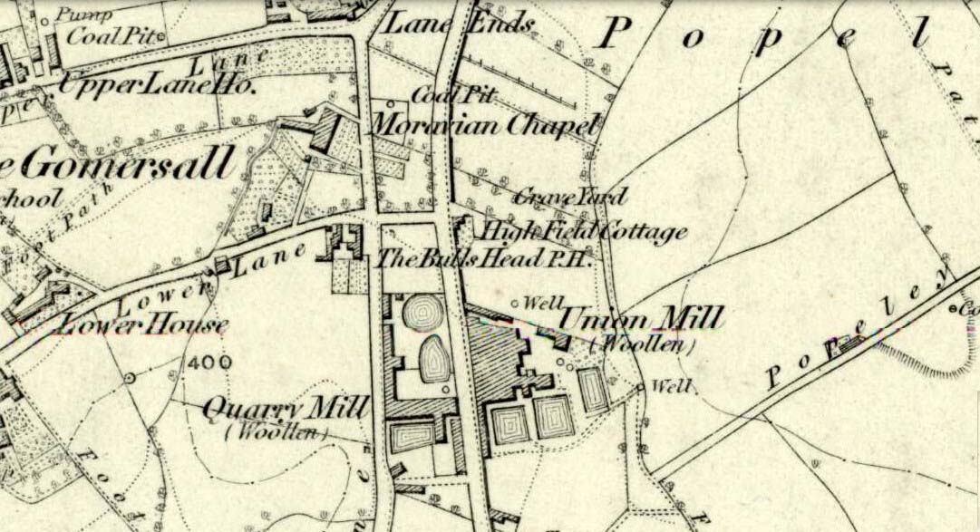
Originally called the ‘Manor Lea Well’ because it could be found on the far west of the land belonging to the Manor House, the name later became corrupted to ‘Mannerly’ by local folk. It was one of the four prime water supplies for this part of the old village, but it had other important social and festive rites attached that undoubtedly went back centuries. H.A. Cadman (1930) told that:
“On Palm Sundays it was the custom for boys to take bottles containing Spanish juice, treacle, and any other sweet thing they could, for the purpose of having them filled with the water from the well. The boys then exchanged bottles with each other and each sampled the others. It was said that no better water existed for this purpose.”
This particular ritual was integral to virtually every Spa Well from Wakefield through to the source of the River Calder.
A Mr G.W. Parker said that the well was to be found at the “extreme Western side” of Manor Lea and was “still in existence” when Cadman wrote about it in 1930, “behind Company Mill” not far from the Moravian Burial Ground. Do any local historians know if the well is still there, or has it since been destroyed?
References:
Cadman, H. Ashwell, Gomersal, Past and Present, Hunters Armley: Leeds 1930.
Sacred Well (destroyed): OS Grid Reference – SE 0973 4091
Archaeology & History
Lund Well on 1852 map
Once found in a cluster of three little wells all very close to each other near the top of the field where the Crossflatts roundabout joins up with the Aire-Valley trunk road, this is an intriguing site if you happen to be a pagan, or have an interest in druidism — and for one main reason: its name. When I first came across a reference to the place about 25 years ago, the only piece of information I could find about it came from the arduous detailed researches of the Victorian industrial historian J. Horsfall Turner who, unfortunately, neglected to record much of the fading folklore in the region at his time. Marked on the 1852 6-inch Ordnance Survey map, ‘Lund’ was a bit of an etymological curiosity, and Mr Turner (1897) thought the well’s name was little other than that of a local mill owner, whose nickname was ‘Lund’ Thompson. He was guessing of course…and I thought little more about it…
Years later when looking through A.H. Smith’s (1961-63) magnum opus on the place-names of West Yorkshire, I found that he didn’t include the Lund Well in his survey. However, an eventual perusal of Kenneth Cameron’s (1996) work told that in Old Norse place-names (and there is a preponderance of such places scattering Yorkshire and Lancashire), lund or lundr was a “‘small wood, grove,’ also had a meaning, ‘sacred grove’.” The word is echoed in old French, launde, meaning ‘forest glade’. In A.H. Smith’s (1954) earlier etymological magnum opus he said that the word derives from a “small wood, grove, also a sacred grove, one offering sanctuary.” However, Margaret Gelling (2000) urged caution on the origin of lund as a sacred grove and erred more to the usual English tendency of depersonalizing everything, taking any animistic attribution away from its root meaning; but we must urge caution upon her caution here! Neither Joseph Wright (English Dialect Dictionary, vol.3 1905) nor William Grant (Scottish National Dictionary, vol.6, 1963) have entries for this word, so we must assume the Scandinavian root word origin to be correct.
One vitally important ingredient with the Lund Well is its geographical position. For across the adjacent River Aire the land climbs uphill—and a few hundred yards above we reach the well-known and legendary Druid’s Altar, with its Druid’s Well just below. This association is what suggests our Lund Well may have had a real association with a “sacred grove of trees”, as—despite us knowing very little about them—we do at least know that druids performed rites in sacred groves. In Greenbank’s (1929) historical analysis of the Druid’s Altar, he was left perplexed as to the origin of its name as all early accounts and popular culture assigned it this title, and so he opted for the probability that the druids did indeed once perform rites here. If this was true, then our seemingly innocuous Lund Well once had a much more sacred history than anyone might have thought. Sadly, through their usual ignorance of such matters, the industrialists destroyed it….
References:
Cameron, Kenneth, English Place-Names, Batsford: London 1996.
Gelling, Margaret, Place-Names in the Landscape, Phoenix: London 2000.
Greenbank, Sydney, The Druid’s Altar, Bingley, R.G. Preston: Bingley 1929.
Smith, A.H., English Place-Name Elements – volume 2, Cambridge University Press 1954.
Smith, A.H., The Place-Names of the West Riding of Yorkshire – 8 volumes, Cambridge University Press 1961-63.
Holy Well (destroyed): OS Grid Reference – SE 3060 3373
Archaeology & History
Lady Lane, where the well was
Deep in the industrial centre of Leeds, not far from the main bus station, could once be found one of Yorkshire’s many ‘Lady Wells’. The great historian and antiquarian Ralph Thoresby (1715) was the first to write of this great spring, which is now lost beneath the concrete buildings near Quarry Hill. He described it as,
“a noted spring…to this day called Lady Well and the adjoining way, Lady Lane.”
In 1806 Edward Baines of Leeds described this spring of “soft, pure water,” also telling it to be on Lady Lane, saying that
“At the bottom of this street is a spring of excellent water, called Lady-Well, which affords a copious supply of that necessary article to this populous part of town.”
This Lady Well was also included in Andrea Smith’s (1982) survey, who noted that less than two hundred yards northwest of was The Chantry of Our Lady. This church has medieval foundations and its dedication would be derived from the healing waters here; plus, Smith notes, in West Yorkshire, “the number of churches dedicated to Our Lady is only two and these are both classed as ancient.”
Healing Well (lost): OS Grid Reference – SE 209 260?
Archaeology & History
This bizarre-sounding well owed its name—if we are to accept H.A. Cadman’s (1930) version of history—to the local land-owner,
“Joseph Mortimer and it was so-called because Mortimer’s christian name was Doidy Poidy.”
But this seems unlikely. The term ‘doidy’ is a local dialect word, seemingly found only in West Yorkshire, meaning ‘an overdressed person, especially female,’ (Haigh 1928), with doidy-poidy being rhyming slang for the same thing. The english dialect magus, Joseph Wright (1900), proclaimed the same derivative, “a badly dressed woman, a dowdy.” So it may have been that this title was endowed upon Mortimer’s wife.
Cadman told that the Doidy Poidy Well was one of the “chief wells” of Gomersal, implying that its waters were good and strong. Its existence on what was known as “the old feasting grounds” may have played a part in the “public rejoicings which last for days… The feast was on the Monday on or before Lady Day.” (March 25th, around spring equinox) However, Cadman assures us that the celebrations were started “when the Gomersal Cloth Hall was opened,” telling us that “this feast or fair is not therefore an ecclesiastical one.”
The exact whereabouts of the Doidy Poidy Well remains a mystery (the map-link, above, shows an approximation from the middle of Gomersal).
References:
Cadman, H. Ashwell, Gomersal, Past and Present, Hunters Armley: Leeds 1930.
Haigh, W.E., A New Glossary on the Dialect of the Huddersfield District, Oxford University Press 1928.
Wright, Joseph (ed.), English Dialect Dictionary – volume 2, Henry Frowde: London 1900.
From the village lane at the east end of Brook Street, take the footpath through the first gate and then over the stile into the woods on your left (north). Soon a clearing will appear on the left hand side as you climb the hill. Careful as you scramble down (look for a swing set up by local children) on the left hand side will be the Devil’s Pulpit.
Archaeology & History
The village name deriving from ‘Helmes’, the genitive singjular of the Old English masculine name Helm, or from helmes, the genitive singular of OE helm ‘a helmet, the summit of a hill, a shelter’, so that the name is either ‘Helm’s spring’ or ‘spring at the summit or shelter’—which does rather neatly defines its topography. However, other authorities suggest its gets its name from elm trees which once grew around the wells.
The site has an eerie but not unquiet atmosphere this is possibly due to the stone called the Devil’s Pulpit, a large approximately six-foot high piece of sandstone under which a small spring arises.
Folklore
This Thompson (1999) in his Lincolnshire Wells and Springs notes local opinion thought was St. Helen’s, he said it tasted sweeten than the other waters (a fact that I cannot testify as the spring has appeared to have almost dried up the year I went). Binnall (1845) notes that the spring wells were regarded as possessing curative powers and rags were hung on the surrounding bushes.
The dedication of St Helen is an interesting one and can be seen as an outlier from those found widely distributed in Yorkshire (Whelan & Taylor, 1989), but rare in the adjoining counties of Derbyshire and Nottinghamshire. Harte (2008) in his English Holy Wells suggests that the name is spurious; and Rudkin’s (1936) Lincolnshire Folklore does not refer to it as such. However, in support of the view, I had no problem locally detecting the well using this name in the village (incidentally Harte makes an error referring to the springs as Aisthorpe Springs, these are clearly another site). There was supposed to be a chapel or church associated with the site, of which there is no trace or record.
Taken from R. B. Parish (2012) Holy Wells and healing springs of Lincolnshire
References:
Cameron, Kenneth, The Place-Names of Lincolnshire – volume 6, EPNS: Nottingham 2001.
Harte, Jeremy, English Holy Wells, Heart of Albion: Loughborough 2008.
o’ Neill, Susanna, Folklore of Lincolnshire, History Press: Stroud 2012.
Rudkin, Ethel, Lincolnshire Folklore, 1936.
Thompson, Ian, Lincolnshire Springs and Wells: A Descriptive Catalogue, Bluestone: Scunthorpe 1999.
Whelan, Edna & Taylor, Ian, Yorkshire Holy Wells and Sacred Springs, Northern Lights: Dunnington 1989.
The site can be found along Wells road, just after the turning for Healing wells farm and after the mirror. One may need to beat through the thickets to reach it.
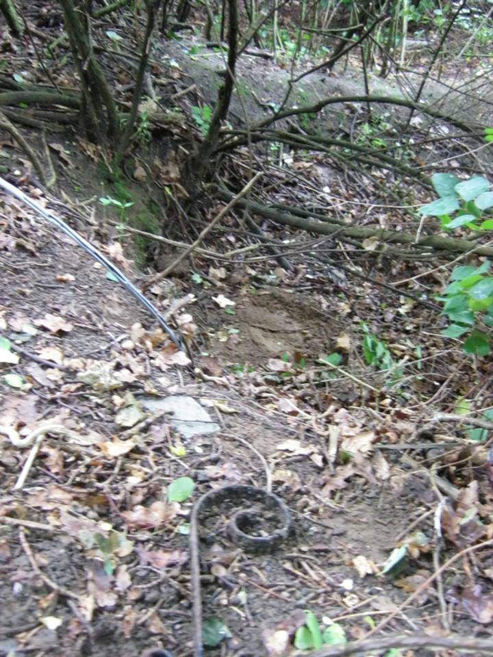
Archaeology & History
The Ragged Spring
Some confusion exists over the relationship between the wells and the parish name. This is possibly an ancient site, as the earliest name for the parish is ‘Heghelinge’ and perhaps derive from the springs. However, this is at variance to the view of Kenneth Cameron (1997) in his Place-Names of Lincolnshire, where it is noted that ‘Hægelingas’ is derived from “the sons or followers of a man named Hægel” rather than healing, although it is of course a strange coincidence!
The springs are still marked on the current OS map, as Healing Wells, in a small plantation, but they are, as the photo shows, only marked by circular indentations in the ground. The first spring is the easier one to trace and it appears to have holes, although these may be made by animals. The springs are now quite dry, perhaps that the clogging of the springs noted above continued as the waters were forgotten, resulting in the current situation. There is no clear lining around the well or other structures. Lying around the springs are a range of metal buckets in various stages of decay and some metal pieces which may be remains of a metal fence around it. Sadly, I was unable to find any sign of rags although the man I asked in the whereabouts referred to them as “the ragged springs.”
Folklore
The Ragged Springs fed a stream where people paddled or hung garments on bushes to acquire good health strangely rather than the wells themselves. Gutch and Peacock (1908) in their County Folklore note that a,
“Mr. Cordeaux visited them not long since for the purpose of discovering whether pins are ever dropped into them, but the bottom of the water in both cases was too muddy and full of leaves to allow accurate examination.”
According to Gutch and Peacock (1908) each well had a different use, one spring being a chalybeate one was done for eye problems, whereas the other was for skin problems. They continue to note that a:
“F S, a middle-aged man, who grew up in an adjoining parish, states that when he was a lad, one spring was used for bathing, and the second for drinking. The latter was considered good against consumption, among other forms of sickness. . . . What the special gift of the bathing well was F S cannot say. He often plunged his feet into it when a boy, but he does not venture to assert that it had any great power in reality, although ‘folks used to come for miles,’ and the gipsies, who called the place Ragged Spring or Ragged Well, frequently visited it. A Gentleman who hunts with the Yarborough pack every winter, says that he notices the rags fluttering on the shrubs and briars each season as he rides past. There is always a supply of these tatters, whether used superstitiously or not, and always has been since his father first knew the district some seventy years ago.”
This would appear to be the site recorded as below under Great Cotes by R.C. Hope (1893) in his Legendary Lore of Holy Wells:
“there is a spring celebrated locally for its healing properties. It rises from the side of a bank in a plantation, and is overshadowed by an ancient thorn, on the branches of which hang innumerable rags, fastened there by those who have drunk it waters.”
The custom apparently continued until the 1940s. Indeed a visitor in the 1920s noted that even the trunks were covered with longer pieces of rag. A picture in the 1995 edition of Lincolnshire Past and Present journal shows a number of rags on the bushes. It is worth noting that perhaps the presence of a large thorn perhaps suggests a great antiquity to the site.
References:
Cameron, Kenneth, The Place-Names of Lincolnshire – volume 5, EPNS: Nottingham 1997.
Gutch, Mrs & Peacock, Mabel, County Folk-lore – volume v: Examples of Printed Folk-lore Concerning Lincolnshire, David Nutt: Folk-lore Society 1908.
Hope, Robert Charles, Legendary Lore of the Holy Wells of England, Elliott Stock: London 1893.
Parish, R.B., Holy Wells and Healing Springs of Lincolnshire. Pixyled Publications 2013
This is the first detailed guide ever written on the holy wells and healing springs in and around the ancient city of Edinburgh, Scotland. Written in a simple A-Z gazetteer style, nearly 70 individual sites are described, each with their grid-reference location, history, folklore and medicinal properties where known. Although a number them have long since fallen prey to the expanse of Industrialism, many sites can still be visited by the modern historian, pilgrim, christian, pagan or tourist.
The book opens with two introductory chapters: the first explores the origin and nature of holy wells and what they meant to local people in earlier centuries; and the next is a comparative overview of water cults worldwide. It is an invaluable guide for any student or tourist who wants to look beneath the modern history of the city and get a taste of the more archaic customs that once belonged here…
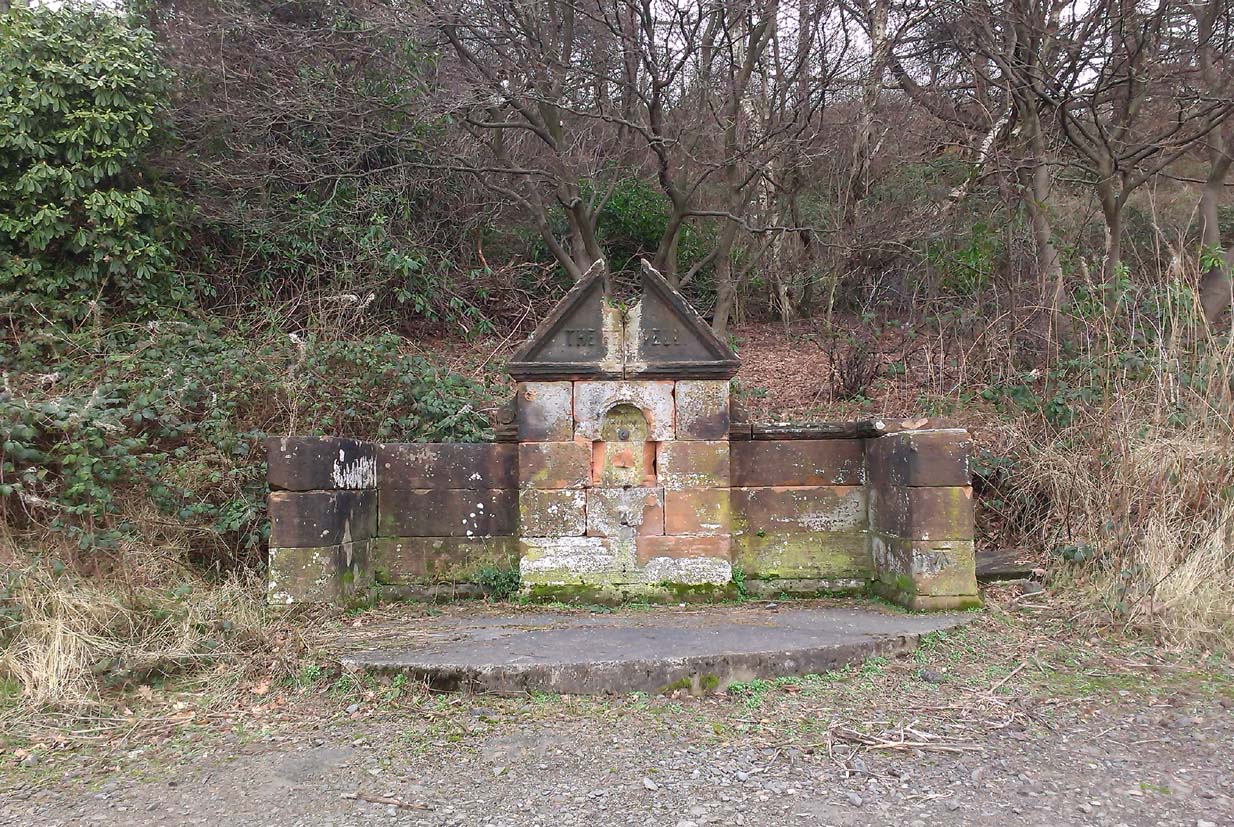
Along the A907 a mile west of Alloa and heading towards Tullibody, just before the roundabout across the road from the school fields, a small entrance takes you into the small wooded parkland. There, right in front of you as you walk in, and visible from the road, is the enclosed architectural stone walling and somewhat ruinous remains that are the Red Well, with its faded name carved on top.
Archaeology & History
Red Well on 1913 map
Although the waters no longer run for the people to drink, this old iron-bearing spring was long of repute to the old folk of eastern Alloa. So much so, it seems, that even Janet & Colin Bord (1985) included it in their national survey of sacred wells! Like other chalybeate springs, its waters were known to be good as a tonic—which makes sense as iron fortifies the blood and general immune system. The Well was highlighted on the 1913 OS-map of the area.
References:
Bord, Janet & Colin, Sacred Waters, Granada: London 1985.
Holy Well (destroyed?): OS Grid Reference – TF 6753 0817
Archaeology & History
Once found in the small woodland known as the High Plantation, this holy well has, seemingly, long since fallen back to Earth. Mary Manning (1994) included it in her survey where she told that in earlier days it could be seen
“in a field which has drainage ditches and cultivation. Here was formerly marshy land draining to the Nar and lying on the south slope of the Nar valley.”
She thought that the title ‘Silver Well’ meant it was a holy site, but others told that it was due to a silver scum that formed on the surface of the waters—and it was a chalybeate (or iron-bearing spring) this is possible.
It was described in Francis White’s (1854) Directory of Norfolk for Shouldham:
“On Mr. Cotton’s estate is a fine chalybeate spring, called Silver Well, which gives rise to a small rivulet which passes through the village. Near this a new spring was discovered about 20 years ago, and both of them possess similar properties to those of Tunbridge Wells.”
This secondary “spring” was another chalybeate well, above which a stone obelisk was erected in 1839.
Folklore
In relation to the object found in the well, Manning (1994) thinks “the objects found could have been pagan votive offerings in a venerated well.” She also told that:
“The well is the subject of a local legend, which takes two forms. One version is that at the Dissolution, treasure from one of the abbeys was hidden in the well. The second says that workmen repairing the well brought up a container/box of silver ware, which was inadvertently dropped back and never recovered. Both tales attribute the silver colour of the well water to the effect of passing over silver treasure.”
A variation on this was noted by folklorist W.B. Gerish (1892) who told that the silver which the workmen dropped back into the well, did so as a result of the devil fighting them over it, and they fled!
References:
Anonymous, Kelly’s Directory of the Counties of Cambridgeshire, Norfolk and Suffolk, Kelly’s Directories Ltd 1925.
Gerish, W.B., Norfolk Folklore Notes, 1892.
Hope, Robert Charles, Legendary Lore of the Holy Wells of England, Elliott Stock: London 1893.
Manning, M., Taking the Waters in Norfolk, NIAS: Norfolk 1994.
White, Francis, Gazetteer and Directory of Norfolk, 1854.
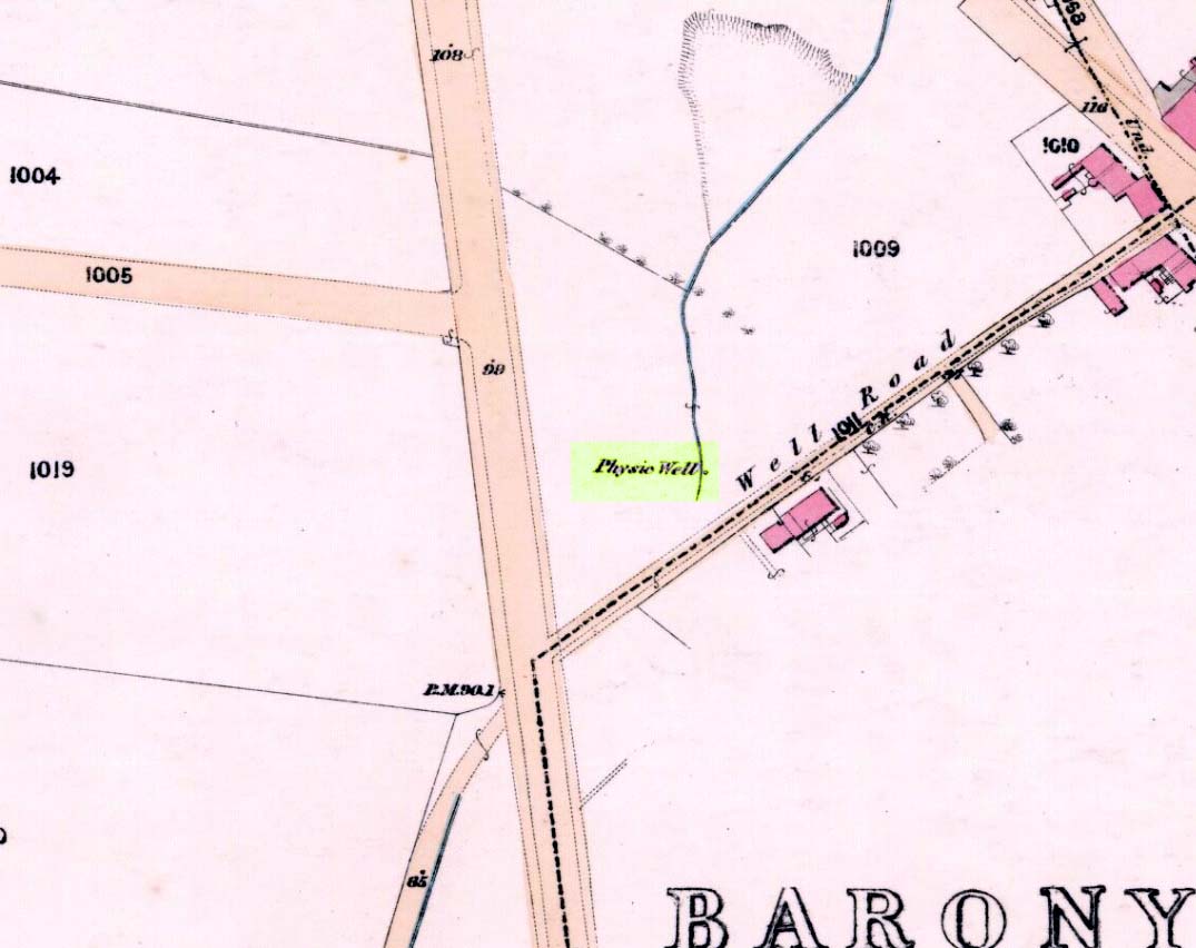
Healing Well (destroyed): OS Grid Reference – NS 5805 6728
Archaeology & History
Physic Well on 1865 map
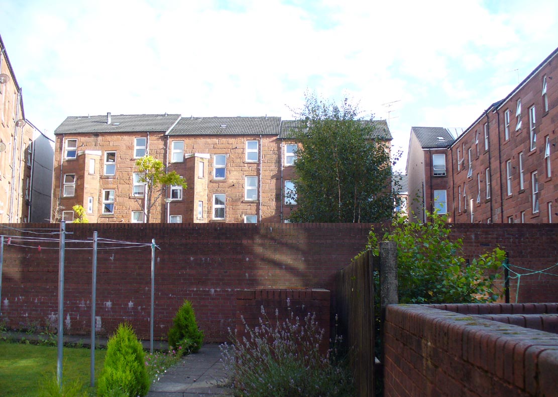
Any site named as a ‘Physic Well’ anywhere in Britain is, by definition, a spring of water renowned for its medicinal properties. Nowadays however, at this and other sites with the same name, local people aren’t even aware that such places exist. A sad state of affairs indeed… This Physic Well was once found just off Trossach Street in Maryhill—which was once called ‘Well Street’, after the medicinal spring itself—in fields just above the road. Today a small housing estate has been built on top of the site and the only sign of it ever being here appears to be marked by a birch tree in the gardens at the middle of the enclosing buildings.
Birch tree marks the spot!
The site was listed in several early 19th century municipal surveys of Glasgow, but the greater references to it seem to be from local people who described it as a place that was visited annually along the perambulation of the old Barony parish, despite it being just over the edge and into Maryhill. In an extensive footnote in Renwick’s Glasgow Memorials he gives us a fascinating insight into the gatherings at the Well, and the popular customs and social activities of the period:
“William Graham, of Lambhill, aged 69, recollected in his school days, “drinking at a well a very little to the north of the Barony glebe, which was called the Physic Well, and there was then a Royalty stone a little to the west of the glebe.” The Physic Well, perhaps all that effective drainage had left of the former loch, otherwise called ‘Plommaris Hole,’ was utilised at the periodic perambulation of marches for impressing on the memory recollection of this part of the boundary. The means taken for this end may be gathered from the evidence of John Alston, weaver, aged 54, who says that, when he was an apprentice, his master told him that it was a custom, “when the magistrates rode the marches to duck some of the last-made burgesses in the Physic Well”; and, on the same topic, James Bryce, victualler, aged 70, depones that, forty years ago, it was commonly reported in the town that at the marches-riding it was the custom “to duck the youngest town-officer in a well called the Physic Well, which is now filled up, but which was near the Barony glebe.” Janet Paterson, widow of William Paterson, labourer, aged 78, recollects of another well, called the Loanhead Well, in the Barony Glebe, from which she carried water when a young girl. ”About 57 yean ago she saw two ploughs going in the Barony Glebe on the Fast Day of the town Sacrament. In general people wrought the Physic Well Park on the town’s Fast Day, but she never saw them working on the Barony Glebe except on the occasion mentioned.” William M’Culloch, farmer, Lightbum, aged 57, says that when Mr. Hill was minister of the Barony parish, the deponent’s father was employed by him, for a good many years, to plough the Barony Glebe, and on one occasion he recollects the glebe being sown and harrowed upon a Fast Day preceding the town Sacrament. Mr. Hill told his father that the glebe was not within the town’s bounds, that the sowing and harrowing it on the Fast Day could disturb nobody, and that his father could have the sowing finished in time to go to church. Peter Ferguson, weaver, aged 5$, had resided in the neighbourhood of the Barony Glebe from his infancy. When he was a boy he heard it very frequently mentioned by old people, as a common report, that when delinquents or debtors, prosecuted before the town courts of Glasgow, were pursued by the town officers, for the purpose of being apprehended, they were in the practice of endeavouring to get across the Howgate Strand; and if they accomplished this they set the officer at defiance and pointed their fingers at them in derision, as being then without the city’s jurisdiction. Howgate Strand was a small run of water which crossed Castle Street, at the south end of the glebe, then passed through the infirmary grounds and joined the Molendinar Burn a little to the north of the High Church. Another witness, Thomas Alston, manucturer, aged 55, places the fugitives’ point of escape at the north end of the glebe. In his young days it was the practice for the town officers to apprehend boys who were playing on the streets upon the Sabbath and the Fast Days preceding town Sacraments; and he remembered well that it was a common opinion with him and his companions that they were safe from the town officers when they got beyond the Physic Well, on the Glasgowfield road, or beyond the spot marked on Mr. Fleming’s plan ‘Toll-house’, on the Kirkintilloch road, as they considered themselves to be then without the town’s jurisdiction.”
The Well was close to a series of old boundary or ‘merche’ stones, but no ancient ones seem to remain.
The medicinal potential for the water was examined in 1771 by a Dr William Irvine, who found it to be a chalybeate or iron-bearing spring, and to possess “a little muriatic acid”, giving the well both tonic and fortifying properties.


 This is the first detailed guide ever written on the holy wells and healing springs in and around the ancient city of Edinburgh, Scotland. Written in a simple A-Z gazetteer style, nearly 70 individual sites are described, each with their grid-reference location, history, folklore and medicinal properties where known. Although a number them have long since fallen prey to the expanse of Industrialism, many sites can still be visited by the modern historian, pilgrim, christian, pagan or tourist.