Martinsell Hill, Oare, Pewsey, Wiltshire

Hillfort:  OS Grid Reference – SU 1764 6396

Also Known as:

  1. Martin’s Hill

Archaeology & History

Martinsell Hill on 1888 map

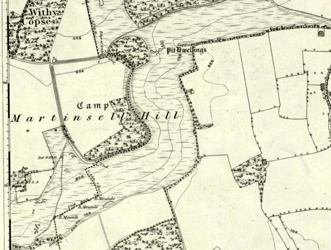
The second highest of Wiltshire’s prehistoric camps or hillforts, Martinsell Hill was described as early as the 13th century as ‘Mattelsore’ and was known in local dialect and literary forms as variants around the word mattels, until the 16th century, when the title became altered in literature and for the first time became known as ‘Martinshall’ (and variants thereof), which has stuck ever since.  As the etymologists Gover, Mawer & Stenton (1939) proclaimed,

“the first element (mattels, PB) must be associated with the old english name for the camp which stands on top of it: the Mætelmesburg of the Pewsey charter” —

A.C. Smith’s old map

Which the authors think derived from “Mætelmesora, i.e., ‘Mæþelhelm’s bank'”, being the name of a tribal leader or elder who gave his name to the hill upon which the fort was built.  Margaret Gelling echoes the sentiment in her Place-Names in the Landscape, but we must keep in mind that such derivation is still a quite speculative etymology and one which doesn’t seem to be able to be proven (as yet!).

The hillfort and its remains were described in some detail in the second volume of Colt Hoare’s classic Ancient Wiltshire (1819: 107), where he wrote:

“Martin’s Hill or Martinshal Hill is in North Wilts what Long Knoll near Maiden Bradley is in South Wilts, ‘collis longe spectabilis’.  This elevated point commands a most advantageous prospect of the rich vale that separates the northern and southern districts of our county, , and is rendered interesting to the antiquary by an extensive earthenwork that crowns the summit of the hill.  Its form resembles an oblong square on all sides, except towards the east, where it bends inward in order to humour the natural shape of the hill.  Its area, which is in tillage, comprehends thirty-one acres; and as several entrances have been made through the ramparts for the convenience of agriculture, it is difficult to ascertain on which side were the original approaches to the camp.  This hill, in its formation, presents a peculiarity rather contrary to the usual system of nature, by rising in height towards the east, where a bold and tremendous precipice of smooth turf shelves down from the summit to the base of the hill.  This eminence is more remarkable for the rich and extensive prospect which it affords than for the plan of its entrenchments, which consists of a single vallum and fosse.  Not having discovered by digging any certain marks of ancient populations within its area, I am inclined to think that it may be considered as an asylum to which the Britons, who were very numerous in its environs, sent their families and herds in times of danger: the single vallum and ditch prove its British origin, and the great extent of its area seems to warrant this conjecture.”

Hippisley Cox’s ground-plan

This aint a bad assumption for a fella who wrote this 200 years ago without the aid of excavation or modern archaeocentric analysis.  But we can see that Hoare was utilizing that dying virtue of common sense here, and find that much of what he said remains the echoed narrative of modern archaeologists who, I believe, still aint done a detailed excavation on the site themselves. (weird for down South!)  Later in the 19th century, when the reverend A.C. Smith (1885) visited and wrote about the hillfort, he added little to Hoare’s earlier words.  And the descriptive narrative of the site remained roughly the same (Massingham’s intriguing ascriptions aside!) even after a small excavation was undertaken in 1907, which found very little.  Hippisley Cox (1927) passed this way in his fine travelogue of ancient roads and trackways in Wessex, describing the enclosed top of this hill as

“the site of a complete neolithic settlement, including dew-ponds, a cattle compound, a flint quarry, lynchetts, dicthes of defence and deep cattle tracks formed by much going and coming of beasts from the valley.”

He may have been right!  In more recent times Geoffrey Williams (1993) describes the Martinsell hillfort, which again only gives slightly more info than Colt Hoare’s 1819 narrative.  The site covers 32 acres in size, is roughly rectangular in form, measuring roughly 330 yards (302m) across east to west, and 480 yards (439m) north to south.   There appears to be at least one entrance on its northeastern edge.

Folklore

What seems to be a survival of prechristian sun lore is found in one or two of the events that used to happen upon and around Martinsell.  A number of local history books give varying descriptions of the events here, but Devereux and Thomson (1979) condense the information nicely, telling us that

“The camp seems to have been a focus for curious Palm Sunday ‘games’ in past centuries, one of which involved a line of boys standing at intervals  from the base to the summit of the hill.  Using hockey sticks, they then proceeded to knock a ball in succession up the hill to the top.  Another activity was the throwing of oranges down the hill slopes with boys going headlong after them.  Evene more strangely, local youths used to slither down the escarpment on horses skulls.”

Mythographer and writer Michael Dames (1977) thought that such festive activities on and around the hill related to remnants of ancient goddess worship here.

Ley line running from Martinsell (image courtesy Paul Devereux)

In Paul Devereux & Ian Thomson’s (1979) ley hunter’s guide, the Martinsell Hill site stands at the beginning of a ley, which then runs northwest for more than seven miles, eventually ending at the well known causewayed enclosure of Windmill Hill — but not before passing by the Avebury stone circle and several prehistoric tombs on route.  This ley is a simple alignment between sites (as the ‘discover’ of leys, Alfred Watkins described them) and has nothing to do with the modern contrivance of energy lines.

…to be continued…

References:

  1. Bradley, A.G., Round about Wiltshire, Methuen: London 1948.
  2. Dames, Michael, The Avebury Cycle, Thames & Hudson: London 1977.
  3. Devereux, Paul & Thomson, Ian, The Ley Hunter’s Companion, Thames & Hudson: London 1979.
  4. Gomme, Alice B., “Folklore Scraps from Several Localities,” in Folklore Journal, 20:1, 1909.
  5. Gover, J.E.B., Mawer, A. & Stenton, F.M., The Place-Names of Wiltshire, Cambridge University Press 1939.
  6. Harding, D.W., The Iron Age in Lowland Britain, RKP: London 1974.
  7. Hoare, Richard Colt, The Ancient History of North Wiltshire, Lackington, Hughes, Mavor & Jones: London 1819.
  8. Massingham, H.J., Downland Man, Jonathan Cape: London 1926.
  9. Partidge, T.B., “Wiltshire Folklore,” in Folklore Journal, 26:2, 1915.
  10. Smith, A.C., A Guide to the British and Roman Antiquities of the North Wiltshire Downs, Wiltshire Archaeological & Natural History Society 1885.
  11. Williams, Geoffrey, The Iron Age Hillforts of England, Horace Books 1993.

© Paul Bennett, The Northern Antiquarian


Rathgall Hillfort, Coolkenna, County Wicklow

Hillfort:  OS Grid Reference – S 9020 7315

Archaeology & History

Early aerial photo of Rathgall hillfort

A prehistoric ‘fort’ with a long history behind it, with recent excavations finding burial and settlement remains from the Bronze- and Iron Ages.  The following article about this impressive archaeological site was written by Barry Raftery’s in an early edition of Antiquity journal (1970), following excavation work here.  He wrote:

“Rathgall is a large and imposing hillfort situated on the end of a long ridge some 6km east of Tullow, Co. Carlow.  It is sited impressively and commands a fine view on all sides.  The defences of the fort comprise four roughly circular, concentric ramparts.  The three outer banks, though largely overgrown, appear to be of earth faced with stone; the inner one is built entirely of granite boulders, many of considerable size.  The fort covers some 18 acres (c. 7 hectares); its overall diameter is about 310m. (Orpen 1911; 1913)

“Excavation in 1969 was confined, with the exception of one short trench, to the inner enclosure.  This is surrounded by the granite wall, dry-built and of poor quality.  It is made up of a series of straight lengths so that, though superficially the enclosure appears to be circular, it is in fact polygonal.  The entrance is a simple break on the western side.  The wall varies in thickness from 7m in the southeast, to 1.5m in the north, though the reason is not immediately clear.  In height the wall varies from 2m to 2.5m.  The minimum internal dimensions of the enclosure are 44m and 46m.

“About one-quarter of the enclosure was excavated in the northeastern quadrant.  A trench 2m wide and 20m long outside the wall and running into the interior was begun and this demonstrated the existence of occupation outside the wall.

“The first season’s excavation suggests the presence of at least three main phases of occupation on the site — Late Bronze Age, early Iron Age and Medieval.  The relatively thin soil covering on the site does not as yet allow the periods to be clearly defined stratigraphically.

“About 1500 objects came to light, over 1000 of them being pot-sherds.  The great majority belong to the Early Iron Age phase of occupation, apparently the period of densest settlement on the site.  As well as the remains of circular and rectangular structures, the excavation also revealed a number of very large hearths and a bank-and-ditch enclosure hitherto quite unsuspected.

“This latter feature partly underlay the granite wall.  The ditch had been filled in and the bank denuded before the construction of the wall.  The latter averaged about 50cm high and lay outside the ditch, which was dug carefully to a V-shaped section.  In width it varied from 1.5 to 3.5m at its edge and in depth from 75cm to 1.1m

“Bank and ditch enclosed an area about 35m in diameter.  So far no entrance to this enclosure has been distinguished, though there appears to be a gap in the south-east which may be an original opening.  It is noticeable that the bank runs, without a break, straight across the entrance to the stone enclosure, further emphasizing the lack of structural connection between the two features.

“The relationship of either of these enclosures to the outer lines of defence is not clear and so elucidation of this problem must await further excavation.  It seems, however, that the granite wall is a late feature and is probably of medieval date.  The massive outer ramparts, on the other hand, are more likely to belong to the Early Iron Age occupation of Rathgall.

“Over the whole area so far excavated indications of rectangular houses were frequent.  The walls of these houses were formed of timber posts, generally of no great size; they were set usually singly but sometimes in paris, in bedding trenches 30 to 40cm wide.  The upright posts presumably formed the framework of wattle-and-daub constructions.  There appears to have been extensive rebuilding, so that the plans are greatly confused and not always easy to interpret.  The houses were quite large: one of them was as much as 7.5m in length.

“These houses belong to the latest phase of occupation on the site and appear to be contemporary with the construction of the granite wall.  They were built on top of the fill of the ditch and were confined by the wall: there is no indication anywhere of house foundations running underneath the wall.  Green-glazed sherd from the fill of the bedding trenches suggests a 13th-century date for these houses and a late 13th-century silver coin points in the same direction.

“A circular bedding trench, apparently concentric with the large V-shaped ditch, was found in the centre of the stone-walled enclosure.  One-quarter of the bedding trench was exposed in the 1969 excavations.  In section it is roughly U-shaped and is 25cm wide and 30-35cm deep.  It encloses a space about 18m in diameter.  Its outer edge is for the most part lined with packing stones of medium size.  One metre inside this bedding trench and running concentrically with it for about one-third of the excavated arc there is a second bedding trench of similar type.  Whether these bedding trenches represent the remains of a large timber house of whether they were for a timber stockade is uncertain; further excavation may provide the answer to this problem.  As regards relative dating, however, it is clear that the circular structure, whatever it was, was earlier than the rectangular houses, for the bedding trenches of the latter lay above the trench for the former.  As well, some sherds of coarse ware of a date appreciably earlier than medieval times were found in the fill of the circular trenches.

“In turn, a huge oval hearth was found beneath the circular structure.  The hearth consisted of a steep-sided, flat-bottomed pit, 3.1m long and 1.5m wide, dug into the yellow subsoil.  A large quantity of black, burnt material came from the hearth and there appeared to be three main phases of use, each separated from the other by a layer of rough cobbling.  The hearth also produced sherds of coarse pottery, including two decorated fragments.  The decoration takes the form of one sherd of a row of finger-nail impressions and on the other a row of simple nicks in the edge of the rim.

“Large hearths of this type are, indeed, a feature of the site as a whole.  Five in all have so far come to light: one, especially elaborate, consisted of a large rectangular pit, 2.85m by 1.2m, dug 40cm into the subsoil.  At each corner there was a circular pit; two of these pits look like post-holes, the other two appear to be much too large to have served such a purpose.  All the hearths have produced coarse pottery and can thus be placed in their relative chronological position, though as yet none appears to be related specifically to any single structure on the site.  It may be that these were open-air hearths, covered by some sort of canopy.

“In addition to the hearths, the rectangular houses, the circular structure and the ditch and bank, a large number of post-holes were found.  Some of these were large, some small, but in no case could any positive pattern be established.

“The importance of the structural remains on the site is equalled by the significance of the material recovered.  The finds from the medieval period have already been referred to and the rectangular houses with which they were associated.  Before this there appears to have been a lengthy period when the site was not occupied.  The occupation before the beginning of this break appears to have been intensive.  It is characterized by large quantities of very coarse pottery.  This distinctive ware may be termed Freestone Hill Ware after the importance of the hillfort site of that name in County Kilkenny where the pottery was first isolated.  At this site it was associated with Roman bronzes of the 4th century AD and with a coin of Constantine II (Raftery, 1969).

“The sherds represent coarse, flat-bottomed, bucket-shaped pots, usually of a reddish, crumbly ware with very large grits.  Distinctive rims are characteristic: they are rounded, flat, T-shaped or internally bevelled.  At Freestone Hill a striking feature was the presence on many of the rim sherds of a row of small perforations; similar perforated rims are included in the Rathgall material.  In addition to the pottery, blue glass beads, bones, spindle whorls, portions of a lignite bracelet and many other objects of normal domestic refuse came to light.  A complete saddle quern was also found.  The most interesting of the Early Iron Age finds, however, was a small tinned strap-mount, beautifully decorated with a combination of openwork and incised curvilinear ornament of sub-La Tene type.  The art on this object has much in common with that on a bronze mount found at Freestone Hill and both appear to have a vital bearing on the transition from the true La Tene art of pre-christian times to the great flowering of art in Early Historic Ireland.

“Both at Freestone Hill and at Rathgall these decorated bronzes were associated with coarse pottery of identical type.  The pottery at the former site was dated to the mid-4th century and there, at least, the date is hardly in doubt.  It is possible to suggest a similar dating for the Wicklow material.  Coarse pottery of this type may, however, have had a fairly long life and indeed Freestone Hill may give but a central date for the group.

“Several points of some significance in relation to this pottery must be stressed.  Firstly, no excavated ring fort (rath) has ever produced this kind of ware — indeed, it is absent from any excavated site of the Early Historic Period in Ireland.  On the other hand, it is found increasingly in hillforts — to such an extent in fact, that it appears more and more to be basically a hillfort phenomenon.  Apart from the two sites referred to above, similar coarse sherds come from the hillforts at Clogher, Co. Tyrone, Emain Macaha, Co. Armagh, Downpatrick, Co. Down, and possibly also from Dunbeg in the same county.  In the present state of our knowledge therefore, it seems that Freestone Hill Ware may be regarded as characteristic of Irish hillforts: there is as yet no evidence for its continuation beyond the middle of the 1st millenium AD.

“The origins and ancestry of Freestone Hill Ware are matters which can hardly be discussed here, but pottery of this type without the perforated rims, may go back to pre-christian centuries.  Indeed, the indications at Emain Macha tend to confirm this possibility and Freestone Hill Ware may well have had its origins in the so-called Flat-rimmed wares of the Late Bronze Age in Ireland.

“This problem seems very real at Rathgall, since here are strong indications of Late Bronze Age activity.  This is the third of the three phases of occupation of the site.  Mould fragments of clay were recovered which were used in the manufacture of objects of Late Bronze Age type — swords, possibly spears and socketed implements with a rope moulding round the mouth of the socket.  The relationship of these fragments to any of the structures which were uncovered during the excavation is not clear.  In fact, apart from the mould fragments (and possibly the saddle quern) there is nothing else which can with certainty be assigned to a late Bronze Age context.  Some of the mould fragments came from the immediate vicinity of one of the large hearth, some from the fill of the ditch, and from the ditch also came the saddle quern.

“The presence of the mould fragments in the ditch is complicated by the discovery, in the very bottom, of fragments of pottery which seem to belong to that class known as Cordoned Ware which occurs in southwestern Britain and northwestern France in the centuries before and just after the birth of Christ.  It would seem then either that the mould fragments found their way into the ditch during an in-filling operation which took place at a time subsequent to the original Late Bronze Age occupation of the site, or alternatively that the pieces are contemporary with the Cordoned Ware, thereby suggesting a remarkable continuity of Late Bronze Age types in Ireland.

“At all events the construction of the ditch can be dated with reasonable certainty to the period of the Cordoned pottery.  Pottery of this type has never before been found in Ireland and its implications regarding Irish/British and Irish/Continental connections in the Early Iron Age — as well as having an important bearing on the development of the Irish hillfort — are considerable.

“The question of the date of the hearths is as yet a matter of some doubt.  It has already been pointed out that in one area  a hearth was overlain by both the circular enclosure and the much later rectangular structures.  This hearth at least belongs to any early phase of the occupation of the site and since all the five hearths so far revealed by excavation are not apparently associated with specific structures and have several points in common, such as size and details of construction, it seems reasonable to suggest that they may be broadly contemporary.

“All the hearths produced coarse ware and it therefore seems to be of prime importance to be able to distinguish between the Freestone Hill type of pottery of the Early Iron Age and the pottery to which the name Flat-rimmed Ware has been given and which is dated to the Late Bronze Age.  It may be that both are in the same developmental tradition and it is hoped that further work on the hillfort at Rathgall will help to elucidate the problem involved.”

References:

  1. Harbison, Peter, Pre-Christian Ireland, Thames & Hudson: London 1989.
  2. Raftery, Barry, “The Rathgall Hillfort, County Wicklow,” in Antiquity journal, volume 44 (no.173), March 1970.

Links:

  1. Rathgall Hill Fort on Irish Antiquities
  2. Rathgall Hillfort on Megalithic Portal

© Paul Bennett, The Northern Antiquarian


Castercliff, Nelson, Lancashire

Enclosure:  OS Grid Reference – SD 8850 3840

Also Known as:

  1. Caster Cliff

Getting Here

Castercliff hillfort plan (after D.G. Coombs)

From Colne train station, cross the road and go along Bridge Street and where it meets Knotts Street follow it all the way up into the countryside and, bending to the right, uphill again until it levels out.  The farmhouse a few hundred yards ahead of you (just off Southfield Lane) at the bend in the road is where you’re heading.  There’s a track on your right, just before the farm.  Go on this and look into the field immediately right.  The undulations and earthworks are the remains of this old hillfort!

Archaeology & History

This old site was constructed some 850 feet above sea level, overlooking the valley of Colne immediately west and giving commanding views of the outstretched landscape towards the sacred Pendle Hill and beyond for many miles.  The place was described as early as Castell Clif in 1515, and then again as Castyclyff in 1533, meaning simply the “castle on a cliff” or high verge as it is here.  Yet despite its early appearances in literary studies, the first real work to explore this monument doesn’t appear to have been done until one J.A. Plummer carried out work on the site between 1958-60.  However, Plummer died before being able to publish his findings in full.   Ascribed variously as a settlement, an enclosure, and generally in the archaeological fraternity as a hillfort, the first detailed published description of the site was done by Forde-Johnston (1965), where he told:

Forde-Johnston’s early plan

“The hillfort is a very regular oval in shape and encloses an area about 350ft long and 250ft wide.  The overall dimensions are 550ft by 450ft.  The site has been affected by quarrying on the south and east and there are a number of gaps in the defences on the northern and western sides.  The character of the remains differs in various parts of the site, but the general pattern appears to be as follows.  The innermost line of defence is represented by a very slight bank or, in many places, only a very shallow scarp which can be traced round the whole circuit of the site… The second or middle bank is the most prominent or substantial of the three.  It has considerable gaps in its length, but the various portions are all of much the same character — it rises between 3 and 5ft above the interior and falls about 9ft to the ditch bottom.  On the south side the middle rampart takes the form of a scarp about 10ft high, immediately below the scarp of the inner rampart.  The third, outermost bank is, in fact, a counterscarp bank to the second ditch.  It does not exist as a continuous bank around the whole of the site, but there are sections of it on the northern and eastern sides.  On the eastern and northeastern sides, from which approach was easiest, there appear to have been additional outer defences, situated about 70ft forward of the counterscarp bank.  These outer defences now take the form of a scarp about 4ft high curving round the eastern and northeastern sides for about 250ft.  At the southern end there is an inner scarp, forming a bank, and a little to the south, is a detached portion of bank.  There are other short detached sections of bank on the northern side which are presumably to be connected with these outer defences.”

When Mr Plummer did his excavation here a few years before, one section of the site was examined and, thanks to the survival of an interim report he did — described by D.G. Coombs (1971) — we know the following of what he did:

“His work was concentrated in the northwest corner of the site where he cut a trench through the defences.  Outside the counterscarp bank, which was not continuous, there was a bedding trench, packed with stones and containing charcoal.  The ditch, which was rock-cut and flat-bottomed, had a homogenous fill.  The rampart itself showed timber supports at the front and back with traces of stone revetting at the front and some distance from the timber uprights.  The rear of the rampart was marked by a line of stones.  Behind this rampart the site had been extensively disturbed and here he claimed to have found traces of primitive iron-smelting furnaces constructed from stones packed and sealed with loose black earth.  A single post-hole beneath the rampart was suggested to belong to an earlier phase.”

Though we have to note here that Mr Plummer believed that the iron furnace remains were actually medieval in date, but that the embanked settlement itself was Iron Age and “that the collapse of the fort could be dated between 60-90 AD.”  When Mr Coombs and his team came back here in 1970 to re-examine the works of both Plummer and Forde-Johnston, they confirmed some of their earlier finds, but uncovered additional finds at what they called this “once great fortress.”

Folklore

In Robert Lord’s (1976) superb imaginary piece on what he calls the Pendle Zodiac (a zodiac allegedly forged into the landscape in ancient times, in the manner of the famous and equally imaginary Glastonbury zodiac), a section of the deity Diana is made up of this prehistoric earthwork:

“The lower edge of the cap (on her head) coincides with a minor road between Colne, skirting the Iron Age Castercliffe hill-fort, above Nelson, as far as Catlow.”

References:

  1. Coombs, D.G., Interim Report: Excavation at Castercliff, Nelson, Lancs., Unpublished Report 1971.
  2. Ekwall, Eilert, The Place-Names of Lancashire, Manchester University Press 1922.
  3. Forde-Johnston, The Hill-Forts of Lancashire and Cheshire, Lancashire & Cheshire Antiquarian Society 1962.
  4. Pennick, Nigel & Lord, Robert, Terrestrial Zodiacs in Britain, Institute for Geomantic Research: Bar Hill 1986.

© Paul Bennett, The Northern Antiquarian


Rough Haw, Flasby, North Yorkshire

Hillfort:  OS Grid Reference – SD 963 558

Getting Here

Travel up the B6265 (Skipton to Grassington road) for a mile, watching on the small hills on your left (western) side, and then take the left turn up to Sandy Beck. You can’t miss the place!

Archaeology & History

Rough Haw, looking west

My first view of this place was from the hills east of here, atop of one of the great rock outcrops on the edge of Embsay Moor. The very first impression it gave me was – “That’s a bloody hillfort!”: an obvious worked rounded hill, with ridges typical of such monuments.  Subsequent investigation found that there were extensive remains of walling, more typical of the Iron Age period than the neolithic (which some modern archaeologists have proposed), clearly visible around the edges of this great hill.  The structure of the site is similar in size and design to the remains at the nearby Horse Close Hill above Skipton, aswell as another (officially unknown) site closer to Keighley.  A large overgrown cairn rests on the southern side of the hill, seemingly more of archaic import than a mere clearance or marker point. But I may be wrong…

Very notable at this site are the profusion of springs emerging from all round Rough Haw: the blood of seven such water sources comes from its edges on all sides and would obviously have been of some importance here.

References:

  1. Dixon, John & Phillip, Journeys through Brigantia – volume 1: Walks in Craven, Airedale and Wharfedale, Aussteiger Publications: Barnoldswick 1990.

© Paul Bennett, The Northern Antiquarian


South Kirkby, South Yorkshire

Hillfort / Settlement:  OS Grid Reference – SE 435 104

Getting Here

From the South Kirkby library, go west along Hague Lane and take the left turn up Homsley Lane on your left after  a few hundred yards (keep your eyes peeled!).  Go up here, past the housing estate, and where the trees begin on your left at the top of the Hilltop Estate, go thru them and as you emerge out the other side, the earthworks are all around you.  In fact you’re just about in  the middle of this hillfort-cum-settlement!

Archaeology & History

W.S. Banks (1871) gives an early description of this site, although he thought it to be Saxon in nature.  He told that,

“About half-a-mile east of Ringston Hill, in a field between Quarry-road and Hornsley-road, is the site of a supposed Saxon camp, as it is called on the ordnance map — a large enclosure containing above three acres of land.  It slopes to the north, and is now rough and uneven, and has been cast into ‘lands.’  The mound on the east, west and south is still very distinct.  The northern side is much lower than the other and a ditch is cut across at that part…”

And in Banks’ day, as he told, “the history of it is not known.”  But this site was later declared as a hillfort – a Brigantian one at that – for the first time by the director of Wakefield Museum, Mr F. Atkinson, following some excavation work here in 1949.  Nothing much was found apart from,

“pieces of decayed and burnt sandstone and medieval pottery sherds,” though he still concluded the site to be Iron Age. Although little of its original form can now be seen due to extensive damage, infra-red aerial photography showed “traces of a five-sided annexe to the northwest, the line of the ploughed-out rampart to the south-southwest, and a possible defended entrance to the south.”

The same aerial survey also found another enclosure to the east of the hillfort.

…to be continued…

References:

  1. Banks, W.S., Walks in Yorkshire: Wakefield and its Neighbourhood, Longmans Green & Co.: London 1871.
  2. Keighley, J.J., ‘The Prehistoric Period,’ in Faull & Moorhouse’s, West Yorkshire: An Archaeological Survey, I, WYMCC: 1981.

© Paul Bennett, The Northern Antiquarian 


Dun Chathach, Connel, Argyll

Hillfort: OS Grid Reference – NM 9674 3401

Also known as:

  1. Canmore ID 23261
  2. Dun Cathich

Getting Here

Dun Chathach (drawn by Miss J. Knox Smith 1885)

Go up from Oban on the A85, past Connel and towards Taynuilt, keeping your eye out for where the train-line crosses the road. Just before this is a small road on your left leading down to the sea, with the train line running parallel all the way down. Go right to the end and then look up to the rocky rise a coupla hundred yards on where the train line runs out of view round the coastal edge. That’s it!

Archaeology & History

When Scottish writer and historian R. Angus Smith (1885) first saw this, the close arrangement and size of the stones that make up the edges of this dun made him think this was actually a stone circle up here.  Sadly it wasn’t to be.  Following an examination of the site in 1969 by members of the Scottish Royal Commission (Argyll – Volume 2, 1975), they described Dun Chathach as,

“circular in plan…measuring 18.3 metres in diameter externally. The wall, which has been about 3.4 metres in average thickness, is now reduced to a low grass-grown stony bank, but considerable stretches of the outer face are still visible in situ. Many of the facing stones, which lie as much as 1.6 metres below the level of the summit, are of massive proportions, the largest measuring 1.4 metres by 1.3 metres and 1 metre high. It is uncertain which of the three gaps now visible in the wall indicates the site of the original entrance.”

Folklore

Legend has it that this was a hill of battles.  It was also said by R. Angus Smith (1885) to “have been used as one of a chain of beacons,” with the next fire on being lit upon a small hill nearer Connel called Tom na h-aire, ‘the mound of watching.’

References:

  1. Royal Commission on the Ancient & Historical Monuments, Scotland, Argyll- volume 2, HMSO: 1974.
  2. Smith, R. Angus, Loch Etive and the Sons of Uisnach, Alexander Gardner: London & Paisley 1885.

© Paul Bennett, The Northern Antiquarian

The Bastard, Campbeltown, Argyll

Hillfort / Dun:  OS Grid Reference – NR 7612 1220

Also Known as:

  1. Canmore ID 38722
  2. Dun Bastard

Getting Here

The Bastard on 1869 map

Pretty easy.  From Campbeltown, follow the coastal round south for about 8 miles, past the TV masts on the skyline and the hamlet of Feochaig, where you’ll see the large rounded hill on your left near the coast: that’s The Bastard!  Go onto the hill’s eastern sides and drop down the steep slope towards the large bend in the burn where its remains are on a ridge close to the cliffs overlooking the sea.  The ruins are pretty faint but if you scout around, you’ll find it.

Archaeology & History

I couldn’t believe it when I found this one – so had to get the notes to the site and add what I could find!  When the fellas from the Scottish Royal Commission checked the place in 1960, they described,

“On a narrow shelf halfway down the east flank of the hill named The Bastard there are the remains of a dun…  Oval in plan, the dun measures about 15m by 12m internally and is entered from the east, where a stretch of the outer face is visible. Here the wall is 4m thick on either side of a straight passageway, 0.9m wide, which exhibits no trace of door-checks.”

The Bastard (RCAHMS 1971)

There are other remains a few yards to the southeast of the main structure which are thought to be “remains of an outer wall…about 1.2m in thickness, which has been drawn across the shelf to provide additional protection for the entrance”, more probably from the weather conditions than invasive incoming humans.

To the immediate north we have a mythic-sounding Giant’s Seat (just above the natural arch) and west is the abode of the fairy folk – but I aint checked out the tales behind them yet.

References:

  1. Royal Commission Ancient & Historic Monuments, Scotland, Argyll – Volume 1: Kintyre, HMSO 1971.

© Paul Bennett, The Northern Antiquarian


Ring Hill, Littlebury, Essex

Hillfort:  OS Grid Reference – TL 515 382

Also Known as:

Getting Here

You can’t really miss this.  Roughly halfway along the B1383 London Road between Littlebury and Wendens Ambo, just above Chestnut Avenue, a dirttrack on the west-side of the road takes you up and onto the wooded hillside. Where the track splits in two, head straightforward up and into the trees until it opens into the clearing. You’re there!

Archaeology & History

This great monument had already been described several times before the Domesday Book had even been thought about!  Indeed, it seems that the town itself gets its name from the hillfort! (Reaney 1935)  Nowadays the place is just about overgrown and covered in woodland.  You cna make out various undulations where parts of the ditches are apparent, but it could do with a clean-out.  Thought to be Iron Age, Nick Thomas (1977) described the site as,

“Oval in plan, this fort follows the contour of the hill it encloses, protecting about 16½ acres… the defences consist of a bank, ditch and counterscarp bank, of which only the ditch is well-preserved.”

References:

  1. Reaney, Paul, The Place-Names of Essex, Cambridge University Press 1935.
  2. Thomas, Nicholas, Guide to Prehistoric England, Batsford: London 1977.

Links:

  1. Ring Hill, Littlebury

© Paul Bennett, The Northern Antiquarian


Dun Dubh, Ford, Argyll

Dun:  OS Grid Reference – NM 8640 0479

Getting Here

From Ford village, take the track that goes uphill (west) running near the edge of the forest-line. Keep going until you hit the top of the forest and the large rocky hill above you (on your right) is where you need to be heading.  The rise to your left is Dun Chonallaich.  Walk around the bottom of the hill until you get to the other side (you should be 100 yards or more above the tree-line) where you’ll notice a ‘pass’ running west, with a rocky knoll above you on your right.  That’s it!

Archaeology & History

Thought to date from the Iron Age, the remains here cover an area 15 yards by about 25 yards.  Remains of walling around the edge of the summit nearly a yard wide in places define quite clearly where the ‘fort’ was centred.  The entrance to the site was found on the northwestern side.  In more recent times however, animal pens have intruded on the remains here and the archaeological remnants are much denuded.

Folklore

Samhain fires were lit on the larger ridge above this ruined fort until recent years, as some old local folk will tell you. These Halloween fires (done to celebrate the old New Year) were stopped a short time after the new ‘owner’ of the Auchinellan Estate (on whose land Dun Dubh is found) took exception to them and, for all intent and purpose, deemed them a fire hazard! The lady in question who inherited the Estate was in fact a devout christian who took exception to the local “pagan” goings-on, contrary to the beliefs of the previous Estate owner, who not only allowed such old events, but played a part in them.  Local folk hereabouts, not surprisingly, aint too keen on their part-time dictatorial christian neighbour.

The fires up here were also related to the linear cemetery at Kilmartin. Here the giant tombs all line up & point to Dun Chonallaich, behind which hides the more flattened top of Dun Dubh. When the Halloween fires were lit on top of this, the glow from behind the great pyramid of Chonallaich all the way down to Valley of the Kings, was spectacular! One wonders just how long the local people had been doing this…

References:

  1. Royal Commission on the Ancient & Historical Monuments, Scotland, Argyll – volume 6, HMSO: Edinburgh 1988.

© Paul Bennett, The Northern Antiquarian


Grianan of Aileach, Carrowreagh, Donegal

Hillfort:  OS Grid Reference – C 36686 19721

Also Known as:

  1. Grianan Ailighe
  2. Grianan of Ailech
  3. National Monument 140

Archaeology & History

Attributed by Michael Dames (1996) and others before him as the abode of the Dagda and the house of the sun, this huge monument was recorded in the Irish Annals as being destroyed in 1101 AD following a great battle.  A site of mythic importance to the very early Irish Kings and Queens, and used by the shamans of the tribes, The Grianan is a place of of legendary importance to folklorists, historians and archaeologists alike and has been widely described over the last 150 years.  Although the site you see today was hugely reconstructed between the years 1874 and 1878, it’s still impressive and, wrote George Petrie (1840), commands,

“one of the most extensive and beautifully varied panoramic prospects to be found in Ireland”!

Used over very long periods of time, the archaeologist Brian Lacy (1983) described the Grianan, on the whole, as,

“a restored ‘cashel’*, centrally placed within a series of three enclosing earthen banks; the site of an approaching ‘ancient road’; and a holy well.”

Grianan of Ailech
Early ground-plan of the Grianon

Lacy’s description in the Donegal Inventory is considerable and culls from the various surveys and reports done in the past.  First surveyed by George Petrie in 1835, the internal body of the stone-built site is roughly circular and measures around 25 yards across, with a singular entrance on its eastern (sunrise) side. A stone ‘seat’ is at the end of the internal passage.  At the centre of the huge ‘room’, Petrie recorded traces of a rectangular stone structure that he thought might have been the remnants of some old chapel built sometime in the 18th century.

More than 25 yards outside of the primary stone building is another surrounding embankment, oval in shape, low to the ground and with another singular entrance to the east — though this entrance is not in line with that of the main structure.  At a further distance out from this embankment are the remains of another two oval ‘enclosures’, though the the remains of the outermost one is considerably more fragmented.

Although the replenished ‘fort’ dates from the Iron Age, early remains here are thought to have been of Bronze Age origin.  A ‘tumulus’, now gone, being one such find here.

Folklore

There is much legend here.  The creation myth narrated by Scott (1938) tells that it was,

“built originally by the Daghda, the celebrated king of the Tuatha de Danann, who planned and fought the battle of the second or northern Magh Tuireadh against the Formorians. The fort was erected around the grave of his son Aeah (or Hugh) who had been killed through jealousy by Corgenn, a Connacht chieftain.”

From similar legendary sources, it is told that,

“the time to which the first building of Aileach may be referred, according to the chronology of the Four Masters, would be about seventeen hundred years before the christian era.  There are strong grounds for believing that the Grianan as a ‘royal’ seat was known to Ptolemy, the Greek geographer, who wrote in AD 120.  In his map of Ireland he marks a place, Regia…which corresponds fairly well with its situation.”

By the outer banking on the south-side of the fortress is the remains of a much-denuded spring of water, the old water supply for this place.  It gained the reputation of being a holy well, dedicated to St. Patrick.

References:

  1. Dames, Michael, Mythic Ireland, Thames & Hudson: London 1996.
  2. Harbison, Peter, Guide to the National Monuments in the Republic of Ireland, Gill & MacMillan: Dublin 1982.
  3. Lacy, Brian, Archaeological Survey of County Donegal, DCC: Lifford 1983.
  4. Petrie, George, ‘The Castle of Donegal,’ in Irish Penny Journal, 1,  1840.
  5. Scott, Samuel, ‘Grianan of Aileach,’ in H.P. Swan’s Book of Inishowen, Buncrana 1938.
  6. Swan, Harry Percival, The Book of Inishowen, William Doherty: Buncrana 1938.

Links:

  1. Guarding the Grianan – the WordPress Word
  2. Grianan of Aileagh – Stone House of the Sun

* Cashels are “monuments similar in type to earthen ringforts, but enclosed by walls of drystone construction.”

© Paul Bennett, The Northern Antiquarian