Cooper’s Well, Partick, Glasgow, Lanarkshire

Healing Well (destroyed):  OS Grid Reference – NS 5619 6654

Archaeology & History

Along the B808, between Beith Street and Byres Road, where it meets the main Dumbarton Road, the memory of Cooper’s Well is preserved in the street-name.  It was one of more than a dozen springs in the area, but was one of the most renowned by local people.

Although not shown on the early OS-maps, thankfully the local historian and folklorist—and early environmentalist, it must be said!—James Napier (1873), gave a good account of it in his excellent work on the traditions of the area:

“Cooper’s Well was situated on the side of the road at the north-west end of Well Street, at the corner of where the Gas-work wall now is.  It was about three feet deep, and had two steps leading down to the water from the road.  Two sides and back were walled up higher than the road, and covered with a stone slab.  It was celebrated in the neighbourhood as a drinking water, being strongly chalybeate, and therefore could not be used for cooking purposes.  Although shallow, it was never frozen during winter (so that it must have come from a considerable depth), and it was cold in summer.  On a warm summer Sunday evening we have seen people, not only from all parts of the village, but from the gentle houses in the neighbourhood, carrying water from the Cooper’s Well to drink.  It is from this well the street has its name.  The Gas-work dried up the well.  There was a story current of some Glasgow people who were visiting at Mr. Sharp’s of Horslethill.  Mrs. Sharp had been baking some oatcakes with butter or dripping in them, which caused them to be very fine and short.  The Glasgow gentlemen were anxious to know how they were baked, and were told that they were baked with the Cooper’s Well water, some of which they had got a drink of.  Shortly after some of the gentlemen sent out their servants to Partick for a supply of the water, but the servants could not succeed in making the cakes so nice as those got from Mrs Sharp.  For long after this, butter-cakes were known in and around Partick as Cooper’s Well bread.”

I have to admit I’ve not visited this site, but presume that all trace of the site has disappeared.

References:

  1. Bennett, Paul, Ancient and Holy Wells of Glasgow, TNA 2017.
  2. Napier, James, Notes and Reminiscences Relating to Partick, Hugh Hopkins: Glasgow 1873.

© Paul BennettThe Northern Antiquarian


St. Constantine’s Well, Govan, Glasgow, Lanarkshire

Holy Well (destroyed?):  OS Grid Reference – NS 553 658

Archaeology & History

This is the conjectural title conferred by T.C.F. Brotchie (1920) upon a Well uncovered during construction of the Pearce Institute in Govan in 1908.  It was certainly an old site and very well made by the sound of it: being “a stone-built well some ten feet deep (and) some eight feet below the present surface of the ground.”  Brotchie thought it to be medieval in age – and he may have been right.

On asking local people if they knew anything about the site, he was lucky to meet “a very old man, a Mr Rellie”, who told him that when he was a boy his granny spoke of a lost “guid well (that) was near the kirk.”  He continued:

“I have no doubt that the well discovered in 1908 was the guid well, and judging from its proximity to the god’s acre, and also from adjective ‘guid’, that the well was at one time the holy well of St. Constantine, who in the 6th century founded a church in Govan.  Of course, that is conjecture, but I venture to think that the conjecture is reasonably well founded.”

The church is immediately adjacent and is indeed dedicated to St. Constantine.  Inside of it are a variety of fascinating archaeological relics: not least of which is what Sam Small (2008) called the ‘Pagan Sun Stone’ upon which is carved an ancient swastika!  That – I’ve got to see!

References:

  1. Bennett, Paul, Ancient and Holy Wells of Glasgow, TNA 2017.
  2. Brotchie, T.C.F., “Holy Wells in and Around Glasgow,” in Old Glasgow Club Transactions, volume 4, 1920.
  3. Small, Sam, Greater Glasgow: An Architectural Guide, Rutland 2008.

© Paul Bennett, The Northern Antiquarian 

St. Mark’s Well, Easterhouse, Glasgow, Lanarkshire

Holy Well (destroyed):  OS Grid Reference – NS 667 653

Archaeology & History

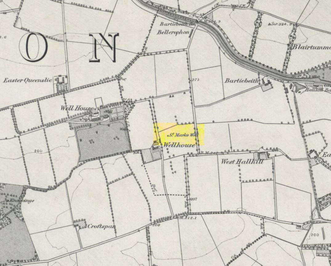
St Marks Well on 1864 map

Information on this long forgotten holy well that once flowed a few miles east of Glasgow city centre, beneath what is now Wellhouse estate, is all but lost.  Local history works of the area tell us little (though there must surely be something somewhere?) and even the place-name surveyor of this area—Peter Drummond (2014)—could find nothing.  Noted by the Ordnance Survey lads in 1858, when they came to re-survey the area again in 1899 its waters had, it seems, been covered and carried into the ‘Well house’ less about 50 yards to the southwest (another ‘Wellhouse’ found 150 yards further west is the site that gives the estate its present name).  From thereon, this wellhouse and St. Mark’s Well fell into the forgotten pages of history and, sadly it seems, even its oral tradition has died…

The origin and nature of the ‘well house’ isn’t too troublesome, as Drummond (2014) explains:

“The name Wellhouse exists in several places in Scotland, and could indicate a ‘house beside wells’, or a protective ‘house over wells’; the early record here suggests the former, since the first Glasgow Water Company’s Act was obtained in 1806, many years later.”

However, the reasons behind the dedication to St. Mark at this probably heathen arena in times gone by, seems to be quite a mystery.  Perhaps the folklore of the saint concerned may be of some help.

Customs practiced on St. Mark’s Eve and St. Mark’s Day (April 24-5) are replete with animistic elements throughout and are certainly not christian!  Six months after the old New Year, we find rituals once more allowing, not for the passing of, but the emergence of the dead: bringing the spirits into the Spring and Summer. Divination rites were practiced with Cannabis sativa no less!  Prophecy and wise-women were advisors to the young.  Walking backwards around wells were known at some St. Mark’s wells; whilst others without his name—but on this saint’s day—were leapt across, symbolizing the crossing of danger and darkness in the ritual calendar. All around this period of time, up to and including Beltane, the end of the dark cold year has passed, and these plentiful rites are prequels to the lighter days, warm spring, summer and good autumn: all vital rites for the people in their myths of the eternal return…

St. Mark’s Well at Glasgow meanwhile, seems to have lost its old tales… Surely not?

References:

  1. Banks, M. MacLeod, British Calendar Customs: Scotland – volume 2, Folk-lore Society: Glasgow 1939.
  2. Bennett, Paul, Ancient and Holy Wells of Glasgow, TNA 2017.
  3. Drummond, Peter, An Analysis of Toponyms and Toponymic Patterns in Eight Parishes of the Upper Kelvin Basin, University of Glasgow 2014.
  4. Eliade, Mircea, The Myth of the Eternal Return, Arkana: London 1989.
  5. Greene, E.A., Saints and their Symbols, Sampson Low: London 1897.
  6. Hole, Christina, Saints in Folklore, M. Barrows: New York 1965.
  7. Wright, A.R., British Calendar Customs: England – volume 2, Folk-lore Society: London 1938.

© Paul Bennett, The Northern Antiquarian 

Kirkton of Culsalmond, Aberdeenshire

Stone Circle (destroyed): OS Grid Reference – NJ 6503 3293

Also Known as:

  1. Canmore ID 18243

Archaeology & History

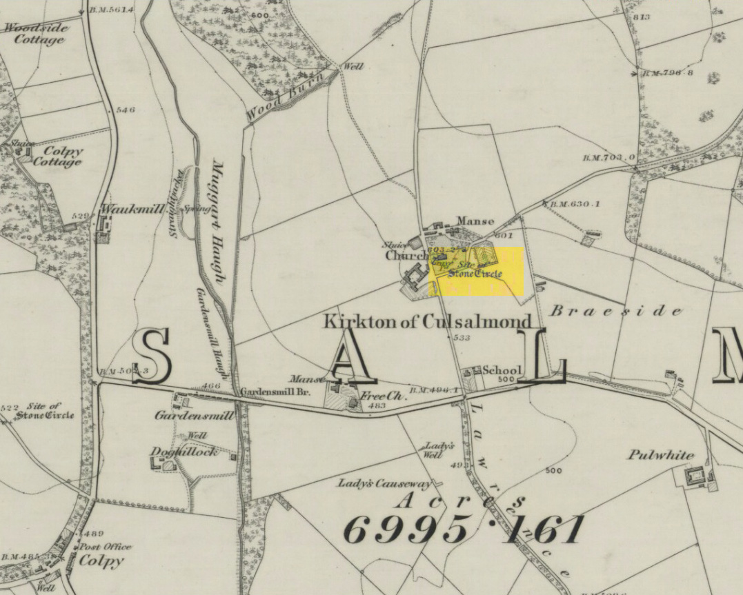
Site of the circle on 1873 map

After standing at the same spot for 3000 years or more, near the beginning of the 19th century this stone circle was destroyed by the self-righteous christian cult that was rampaging its way through cultures far and wide.  After all, they needed to rid the area of local traditions and “improve” the locals, whether they liked it or not!  Thankfully however, one of their creed—a reverend Ferdinand Ellis: minister of the parish for forty years—recorded its destruction in the New Statistical Account between 1834-45. Amongst a variety of important traditional monuments that once existed hereby,

“A Druidical place of worship anciently stood about the middle of the churchyard or burying ground.  It consisted of a circle of twelve upright large granite stones from Benochee, which were overturned when the first Christian temple was erected.  One of these was taken up in 1821 and now remains above ground, near the spot where it was taken up.  The other eleven are still underground.  This is proof that the first christian missionaries, in this country, erected their places of worship as near as possible to the holy hills of the heathens, that the people might be more easily persuaded to assemble there.”

Persuaded‘ being a very broad term indeed when it came to the land confiscation of indigenous folk…

The stone that Ellis said “was taken up in 1821 and now remains above ground” was gone when Fred Coles (1902) surveyed the site, but he told how an earlier antiquarian and writer for the Scottish Society of Antiquaries, J.G. Callander, lived nearby, and who was

“told by the aged sexton, Florance, that he many a time came across a great stone, when preparing graves, and that he had himself blasted these more than once.”

It seems that all trace of this single stone, and the rest of them, either still lay in the ground or were used for local building material.

When John Barnatt (1989) came to add this circle in his corpus, for some reason he postulated that

“the number of stones suggest it was a recumbent stone circle”,

…that is: a stone circle possessing one large stone in the ring that’s laid down with two standing stones either side.  However, there seems no real evidence to show that this was the case.

References:

  1. Barnatt, John, Stone Circles of Britain – volume 2, BAR: Oxford 1989.
  2. Browne, G.F., On Some Antiquities in the Neighbourhood of Dunecht House, Aberdeenshire, Cambridge University Press 1921.
  3. Burl, H.A.W., “The Recumbent Stone Circles of North-East Scotland“, in Proceedings Society of Antiquaries, Scotland, volume 102, 1973.
  4. Burl, H.A.W., The Stone Circles of the British Isles, Yale University Press 1976.
  5. Burl, H.A.W., The Stone Circles of Britain, Ireland and Brittany, Yale University Press 2000.
  6. Coles, Fred R., “Report on Stone Circles in Aberdeenshire (Inverurie, Eastern Parishes, and Insch Districts),” in Proceedings Society of Antiquaries, Scotland, volume 36, 1902.

© Paul Bennett, The Northern Antiquarian

Silver Well, Shouldham, Norfolk

Holy Well (destroyed?):  OS Grid Reference – TF 6753 0817

Archaeology & History

Once found in the small woodland known as the High Plantation, this holy well has, seemingly, long since fallen back to Earth.  Mary Manning (1994) included it in her survey where she told that in earlier days it could be seen

“in a field which has drainage ditches and cultivation. Here was formerly marshy land draining to the Nar and lying on the south slope of the Nar valley.”

She thought that the title ‘Silver Well’ meant it was a holy site, but others told that it was due to a silver scum that formed on the surface of the waters—and it was a chalybeate (or iron-bearing spring) this is possible.

It was described in Francis White’s (1854) Directory of Norfolk for Shouldham:

“On Mr. Cotton’s estate is a fine chalybeate spring, called Silver Well, which gives rise to a small rivulet which passes through the village.  Near this a new spring was discovered about 20 years ago, and both of them possess similar properties to those of Tunbridge Wells.”

This secondary “spring” was another chalybeate well, above which a stone obelisk was erected in 1839.

Folklore

In relation to the object found in the well, Manning (1994) thinks “the objects found could have been pagan votive offerings in a venerated well.”  She also told that:

“The well is the subject of a local legend, which takes two forms.  One version is that at the Dissolution, treasure from one of the abbeys was hidden in the well.  The second says that workmen repairing the well brought up a container/box of silver ware, which was inadvertently dropped back and never recovered.  Both tales attribute the silver colour of the well water to the effect of passing over silver treasure.”

A variation on this was noted by folklorist W.B. Gerish (1892) who told that the silver which the workmen dropped back into the well, did so as a result of the devil fighting them over it, and they fled!

References:

  1. Anonymous, Kelly’s Directory of the Counties of Cambridgeshire, Norfolk and Suffolk, Kelly’s Directories Ltd 1925.
  2. Gerish, W.B., Norfolk Folklore Notes, 1892.
  3. Hope, Robert Charles, Legendary Lore of the Holy Wells of England, Elliott Stock: London 1893.
  4. Manning, M., Taking the Waters in Norfolk, NIAS: Norfolk 1994.
  5. White, Francis, Gazetteer and Directory of Norfolk, 1854.

© Paul Bennett, The Northern Antiquarian 

Maypole, Hemswell, Lincolnshire

Maypole: OS Grid Reference – SK 92954 90947

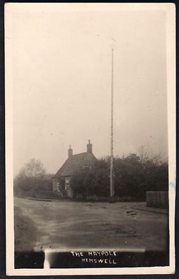
Historic photo from Church Street

Also Known as:

  1. English Heritage ID: 196736

Getting Here

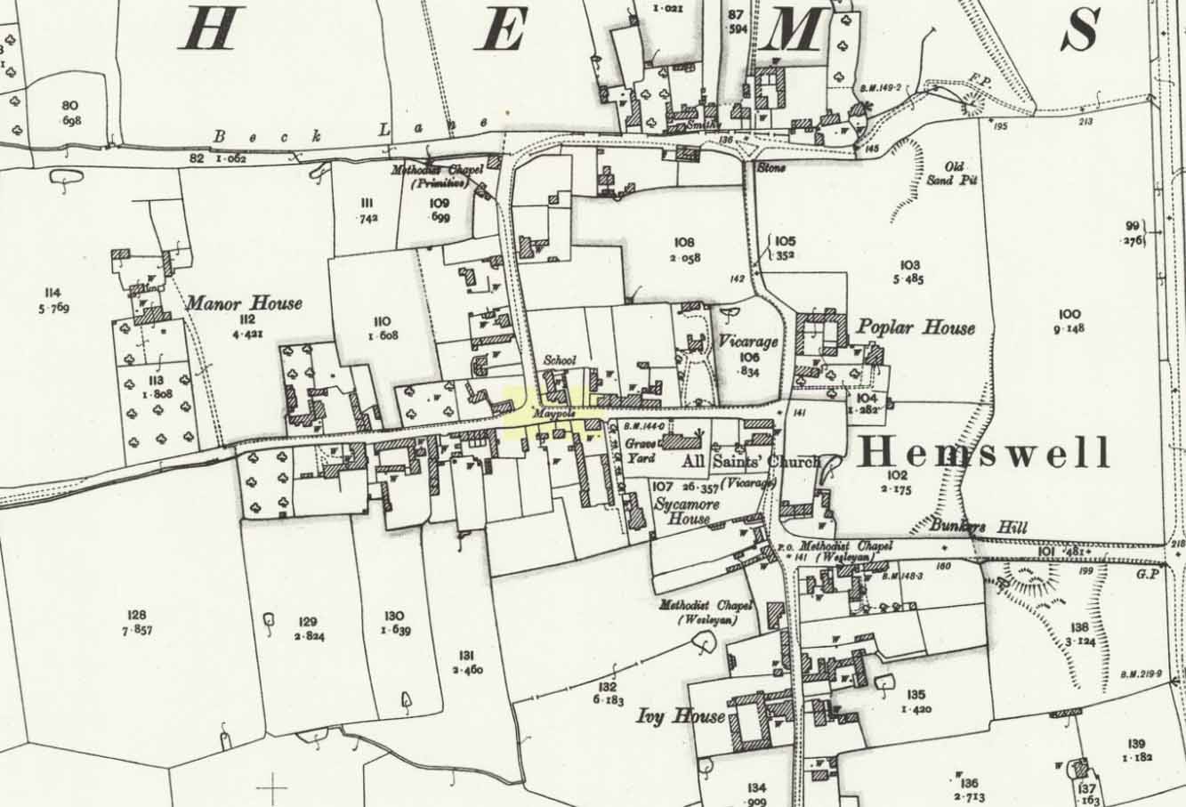
In Hemswell Village at the junction of Church Street and Maypole Street.

History & Archeaology

According to a 2010 report in the Scunthorpe Telegraph, the Hemswell villagers,

“claim to be the hosts to one of the oldest maypole celebrations in the world, dating back to at least 1660”.

The then clerk to the parish council, Dianne Millward is quoted as saying:

“Hemswell is widely regarded in historical circles as having one of the oldest if not the oldest celebrations for May Day. We have pictures of the pole being prepared for the big day in the very early 1900s.”

Hemswell maypole on 1906 map

This writer has not yet been able to independently verify these claims.

May Day is still celebrated in the village with dancing around the maypole and an accompanying fete. Recent online photographs show that it is now only children, in ‘historic’ fancy dress who ribbon-dance around the Pole.

© Paul T. Hornby 2016 The Northern Antiquarian


The Maypole, Alconbury, Huntingdonshire

Maypole (removed):  OS Reference Number TL 18554 75972

Getting Here

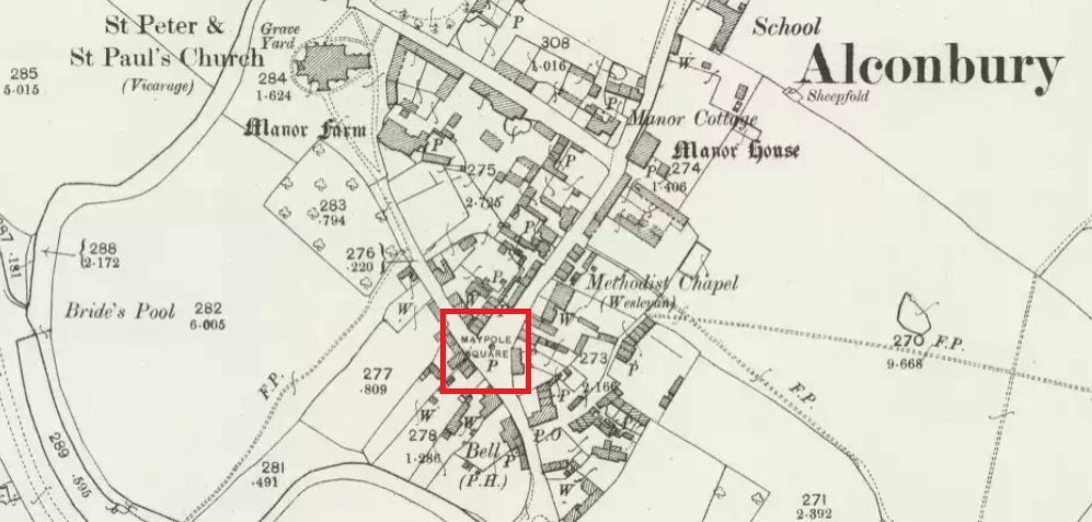
Maypole Square, outlined in red on the 1901 OS map

Maypole Square forms the junction of High Street, Church Way and Chapel Street in the centre of the village.

Archaeology & History

The Alconbury Maypole had passed out of living memory by 1942, but was historically attested by the ‘Maypole Square’ in the centre of the village.

Folklore

C.F. Tebbutt wrote in 1950:

“At Alconbury, it is remembered that about 1890 an old soldier, who lived in the corner house (east end) of the row of cottages facing Maypole Square, used to dig holes in the road opposite the row and set up May bushes there on May day”.

References:

  1. C.F.Tebbutt, “Huntingdonshire Folk and their Folklore”, in Transactions of the Cambridgeshire and Huntingdonshire Archaeological Society, Volume VI, part V, 1942.
  2. C.F.Tebbutt, “Huntingdonshire Folk and their Folklore II”, in Transactions of the Cambridgeshire and Huntingdonshire Archaeological Society, Volume VII, part III, 1950.

© Paul T. Hornby 2016 The Northern Antiquarian


Bogle’s Well, Glasgow, Lanarkshire

Sacred Well:  OS Grid Reference – NS 597 650

Archaeology & History

Of all the ancient wells in the city of Glasgow, this has to be one of the most intriguing! Descriptions of it are few and far between, but it is the name of the site which is of interest, to folklorists and occult historians alike.  For the word ‘Bogle’ is another term for a ‘boggart’ or goblin of some sort!  The well is mentioned in Andy MacGeorge’s (1880) excellent study in his description of ancient wells in the city. Citing notes from the 17th century, amidst many sites,

“Another was Bogle’s Well, in regard to which there is a minute of the town council “that Bogillis Well should be assayed for bringing and convoying the water of the same to the Hie street according to the right the town hes thereof,” and the magistrates are recommended to arrange for having this done “by conduits of led.””

…Obviously in the days when they were clueless about lead-poisoning!  The word ‘bogillis’ is the early plural form of the bogle, or bogill (Grant 1941:201).  But where exactly was this old well?  Are there any other records hiding away to help us locate its original position?  It seems to have been one in a cluster of legendary and holy wells in a very small area scattered between Glasgow’s cathedral, down the High Street and to the northern banks of the River Clyde… (the grid-reference given for this site is an approximation)

In a less esoteric fashion, the occult historian Jan Silver suggested that the name of the Well may relate to the family name, ‘Bogle’.  This could indeed be the real story behind the well’s name.

Folklore

Traditionally ascribed in the lower counties of England to be an evil malicious sprite, in more northern counties and in Scotland the creature was said by Katherine Briggs (1979) to be a more “virtuous creature”, akin to the helpful brownies or urisks of country lore.  This was said to be the case in William Henderson’s (1868) Folklore of the Northern Counties. Whether this well was haunted or the home of a bogle, we do not know as the folklore of this site appears to be lost; so I appeal to any students who might be able to enlighten us further on the place.  The Forteans amongst you might have a cluster of ‘hauntings’ hereby, perhaps….

References:

  1. Bennett, Paul, Ancient and Holy Wells of Glasgow, TNA 2017.
  2. Briggs, Katharine, A Dictionary of Fairies, Penguin: Harmondsworth 1979.
  3. Grant, William (ed.), The Scottish National Dictionary – volume 2, SNDA: Edinburgh 1941.
  4. Henderson, William, Notes on the Folklore of the Northern Counties of England and the Borders, W. Satchell: London 1879.
  5. MacGeorge, Andrew, Old Glasgow, Blackie & Son: Glasgow 1880.
  6. MacKinlay, James M., Folklore of Scottish Lochs and Springs, William Hodge: Glasgow 1893.
  7. Steele, Joyce, Seeking Patterns of Lordship, Justice and Worship in the Scottish Landscape, Glasgow University 2014.

© Paul Bennett, The Northern Antiquarian

The Maypole Tree, Little Paxton, Huntingdonshire

Maypole & Ritual Tree (destroyed):  OS Grid Reference TL 18831 62757

Getting Here

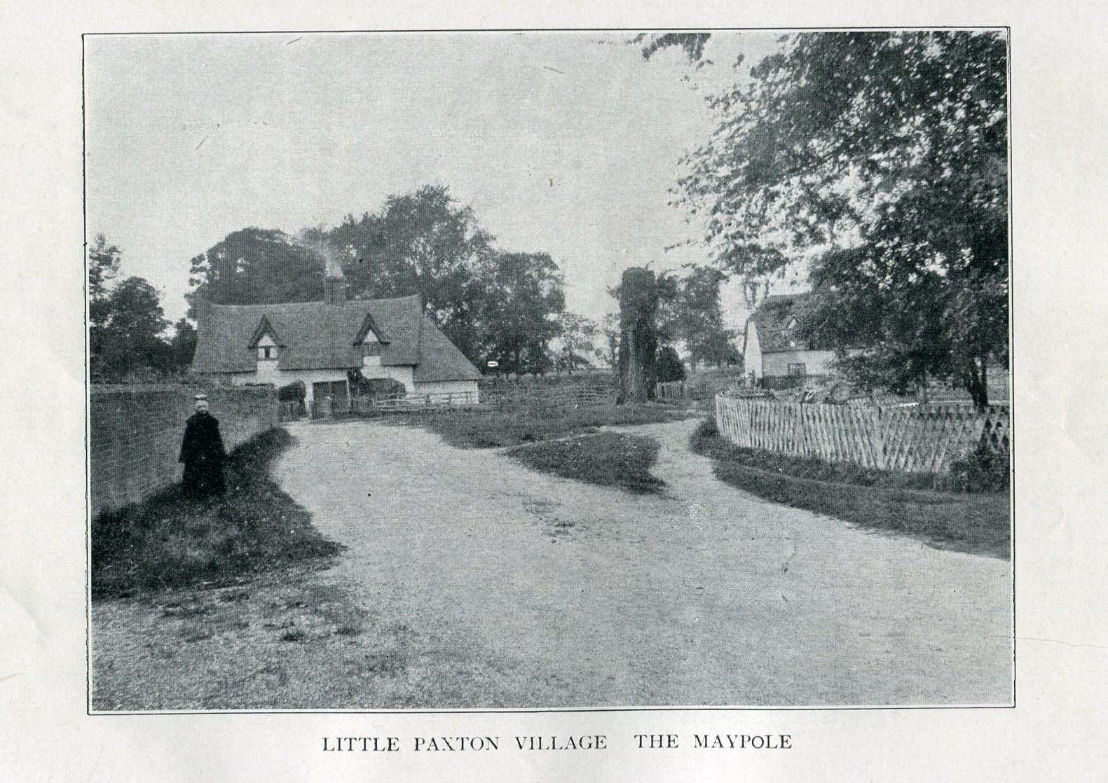
Imposing trunk of The Maypole Tree, right background

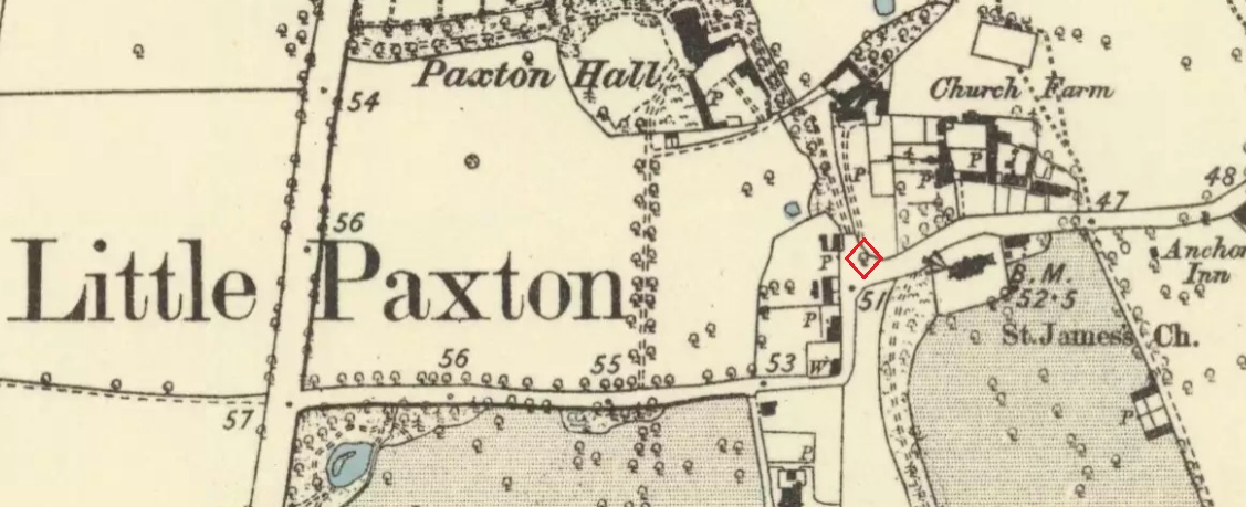
The road layout of the village has changed since the destruction of the Tree, but its approximate position was on the north side of the present High Street, at the junction with the east side of St James’ Road.

Archaeology & History

The Little Paxton Maypole Tree was a very late survival of a tradition where Mayday revellers danced around an actual tree rather than a symbolic tree in the form of a maypole.  It was described as “a tall straight elm tree” that stood in front of what was then the village Post Office, and from what may be the only surviving photograph, it appears that only the very substantial trunk survived of what was clearly a very old tree.

The 1887 6" OS Map, showing the Maypole Tree outlined in red
1887 6″ OS Map, showing the Maypole Tree outlined in red

A Miss Ethel Ladds, who had been born in Little Paxton, recalled in the early 1940s:

I remember the old tree very well, it was always called ‘the Maypole’, but I don’t know any more about it, except that they used to dance round it“.

The St Neots Advertiser recorded that the Maypole Tree was blown down in a great gale on 24th March 1895.

Folklore

While this writer has been unable to find direct folklore relating to the Little Paxton Maypole Tree, it may be worth remarking that botanically the Elm tree is a cousin of the Stinging Nettle, the Hop and Cannabis.  Another Elm Tree used for May revels was the Tubney Elm, near Fyfield in Berkshire and recorded by Matthew Arnold, in his ‘Scholar Gipsy’.

References:

  1. C.F. Tebbutt, “Huntingdonshire Folk And Their Folklore”, in Transactions of the Cambridgeshire & Huntingdonshire Archaeological Society, Volume VI, Part V, 1942
  2. C.F. Tebbutt, “Huntingdonshire Folk And Their Folklore”, in Transactions of the Cambridgeshire & Huntingdonshire Archaeological Society, Volume VII, Part III, 1950
  3. Gerald Wilkinson, Epitaph For The Elm, Arrow Books, London, 1979

© Paul T. Hornby 2016 The Northern Antiquarian 


St. Conval’s Well, Eastwood, Glasgow, Lanarkshire

Holy Well:  OS Grid Reference – NS 5519 6020

Also Known as:

  1. St. Ninian’s Well

Archaeology & History

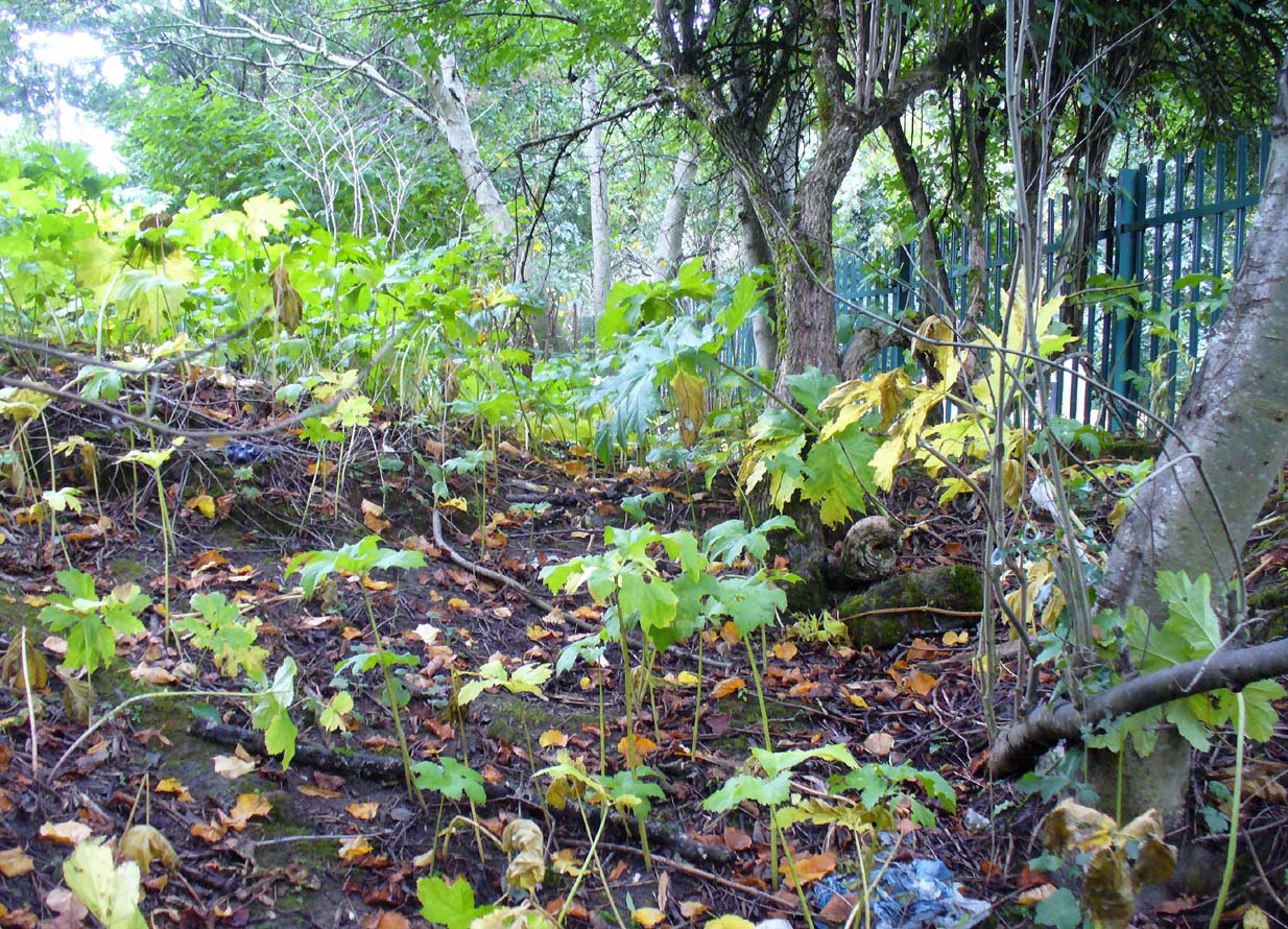
Site of St Conva's Well, beneath the elder tree, off-centre
Site of St Conval’s Well, off-centre beneath the tree

This all-but-forgotten holy well was becoming nothing but a faded memory even in the middle of the 19th century.  Excluded from all of the previous Scottish holy well surveys, the site is mentioned in George Campbell’s Eastwood (1902) where, in his description of the obscure saint, St. Conval or Convallus—to whom Eastwood parish was dedicated—the position of the well is mentioned.  When St. Conval first came to the area, said Campbell,

“The particular spot which the saint selected for his cell would be determined, as was so commonly the case, by the then remarkable spring which can still be traced in the lower part of what was the glebe before the excambion in 1854.  Within the memory of man, even of my own, as I resided for a year in the old manse, before its removal from the early site, this well, as stated in the last Statistical Account, discharged about eleven imperial pints a minute, and was perennial, affected neither by drought nor rain.  Up to that date the water was sufficiently abundant to supply the manse and all the families in what was still a bit of a hamlet, the remains of the Kirkton, as it was formerly called.  But coincident to the removal of the last living remains of an ecclesiastical establishment from the spot, it has well nigh dried-up, through disturbances caused, it is believed, by the working of pits and quarries in the neighbourhood; but it is confidently hoped that what remains of it may be preserved, and a memorial erected over it of the long-departed past, situated as it is within the enclosure of the now extended burial ground.  There can be no doubt that in its waters our fathers were baptised when they renounced Druidism, or whatever was their pagan form of faith, and a sacredness would thus naturally attach to it in former times…”

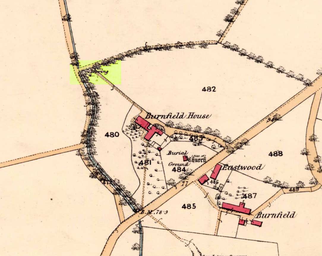
Site on 1863 map as 'Spring'
Site on 1863 map as ‘Spring’

When we sought out this well in the furthest corner of the old churchyard—where Ordnance Survey placed the ‘Spring’ on the 1863 map—we were greeted by a completely dried-up site, long since fallen back to Earth, with little hope of it ever resurfacing unless good local people choose to do something.  The well was surrounded by excrement and litter and it truly needs a good clean-up and a dig down to bring the waters back to the surface.

In an Appendix to Campbell’s Eastwood, he tells that he came across a map-reference to the site, where it was shown as “St. Ninian’s Well”, but I have been unable to locate this.

References:

  1. Bennett, Paul, Ancient and Holy Wells of Glasgow, TNA 2017.
  2. Brotchie, T.C.F., “Holy Wells in and Around Glasgow,” in Old Glasgow Club Transactions, volume 4, 1920.
  3. Campbell, George, Eastwood: Notes on the Ecclesiastical Antiquities of the Parish, Alexander Gardner: Paisley 1902.

Acknowledgements:  Huge thanks to Paul Hornby & Nina Harris for helping to locate the spot where this old well once existed.

© Paul Bennett, The Northern Antiquarian