Very little appears to have been written about this site, due no doubt to lack of archaeological investigation aswell as the destructive powers of intense agricultural practices hereby. It was first described in the Yorkshire Archaeological Register and told about by a Mr. H.G. Ramm, who told us of,
“a probable cursus in the Scales, Fimber Grange and Fimber Station area. An aerial photograph taken by John Dent has entended parallel ditches previously known in fragmentary form and enabling them to be interpreted as a cursus running along the valley floor, the north ditch from SE 8939 6106 to SE 9075 6104 and the southern ditch from SE 8937 6103 to SE 9068 6102. The distance between the ditches varies from 18-27m west of Fimber Grange to 30-37m east of the Grange. A trapezoidal enclosure, 30m by 15m, possibly a small long barrow, has been identified at SE 9008 6104, oblique to the north cursus ditch, which bends to take in account of it. A group of five ring ditches, three of which are in the cursus, lies to the west of Fimber Grange, but indicate a wartime searchlight post.”
This makes the length of this monument pretty short, but the faint remains of this possible cursus are visible on aerial shots. A number of other large ancient earthworks were charted here by the famous archaeologist, J.R. Mortimer (1905), though he made no mention of this particular site.
More info please!
References:
Edmondson, T., History of Fimber, H. Smithson: Malton 1857.
Gutch, Mrs. E., Examples of Printed Folk-lore Concerning the East Riding of Yorkshire, David Nutt: London 1912.
From junction 49 on the A1 (M), Dishforth turn-off, bear west on the Copt Hewick and Ripon road. 100 yards past Copt Hewick, take the track on the right-side of the road, leading to Blois Hall and further up to Low Barn. Once at Low Barn, go north through the trees called Harland’s Plantation and the barely visible henge remains are in the field on the other side – as PeteG’s fine aerial photo here shows!
Archaeology & History
At ground-level there’s not too much to see of this once fine henge, thanks to the usual excesses of modern agriculture and modern industry. Which is a pity, as the completed monument here was similar in size and lay-out to the three huge henges a few miles north at Thornborough. Archaeologist Jan Harding (2003) believes this and the Thornborough henges and others nearby, suggests “there was a unity of purpose behind” all of them, in terms of their lay-out, alignments and ritual purpose. He may be right. Aubrey Burl thinks similarly, noting how,
“The central plateau of these enclosures are remarkably similar in shape and size, slightly ovoid and varying no more than 5 metres or so from a norm of 97 by 92 metres. All have their entrances near the northwest and southeast following the lie of the land.
Each of them could have held as many as two thousand people and yet they crowd together in a narrow rectangle 11km (7 miles) long and no more than 1.5km (1 mile) across, like an avenue of architect-designed houses with a river frontage to their west.”
Intriguing stuff – and all from the neolithic period. But focussing on Hutton Moor’s monument, …
In Walbran’s (1851) historical work on Ripon and district, he gave us one of the earliest descriptions of Hutton Moor’s henge, telling:
“we have far more direct and conclusive evidence, that the immediate vicinity of Ripon was regarded with peculiar interest and veneration ; since one of the tribes of the Brigantian Celts had chosen it as their station for the dispensation of justice and the celebration of religious rites ; in fact, had made it the seat of their government. This position — novel as it may be — is, I believe, sufficiently proved.by a remarkable earth-work on the high land near ” Blows Hall,” commanding extensive prospects up and down the Vale of Ure, as well as of the distant ranges of hills which form the side screens of the great Yorkshire plain. Like Abury and Stonehenge, which it rivals in antiquity, its outline is that of a circle, of which the diameter is not less than 680 feet ; but no stones remain, nor indeed does that material seem to have been used in its formation. Though recent agricultural operations have partially effaced the regularity and proportion of its plan, it is sufficiently evident that it was enclosed by a lofty mound and corresponding trench — the latter being inside, and a platform or space about thirty feet wide intervening.
“…At two opposite points, bearing nearly north and south, the mound and trench, for about the space of twenty-five feet, have been discontinued, in order to form an approach to the area of the temple. Outside the mound, also, are some slight vestiges of a further avenue, but too indefinite to be traced. But, however obscure the denotation of its several parts may have become, the antiquity and purpose of the place, as a temple for the performance of Druidical rites, is satisfactorily ascertained by the existence of at least eight large Celtic barrows in its immediate vicinity ; one of which, being on the very ridge of the vale, and planted with fir trees, forms a conspicuous and useful object to guide a stranger to the site. Two of these barrows were opened five years ago, but I found nothing but a few calcined human bones, the ashes of the oaken funeral pile, and some fragments of flint arrow-heads, such as are still used by the North-American Indians. Several bronze spear-heads and celts have, however, been found in the neighbourhood, within recollection.”
Walbran also described there being some upright stones at the henge:
“two small pyramids or obelisks, built on the mound of the temple, about fifty years ago, in the place, it is said, of two similar erections, apparently of high antiquity.”
Loveday (1998) addressed some interesting notes about potential alignment features at henges first described in Anthony Harding’s (1987) text, Hutton Moor included — i.e., the angle of their respective entrances/exits very closely mirror the alignment of adjacent Roman roads. Curious correlates akin to the ley hunter’s assertions find the alignment or direction of nearby Roman roads is echoed in the alignments of henge entrances. Now this wouldn’t seem too unusual, but in 4 out of 5 henges, this peculiar parallel has been found. The Hutton Moor henge is no exception; with its aligned entrances closely paralleling the ancient straight Roman road of the A1 (though there are evidences of a pre-Roman track preceding the Roman construction), less than a mile to the east. The same alignment is echoed in all of the Ure Valley henges.
Folklore
Ley alignment at Hutton henge
This is a site that seems to have been laid out in some form of linear arrangement in prehistoric times. The notion was first posited in Norrie Ward’s (1969) work, but later expanded in Devereux & Thomson’s (1979) survey of prehistoric alignments. Although the axis of the henge doesn’t line up with other sites surveyed, they include it in what’s known as the “Devil’s Arrow’s Ley” and the western side of the henge lines up with the Devil’s Arrows and other sites along the line. When this ley was assessed for statistical probability, Robert Forrest found the alignment to have a probability much greater than that of chance.
References:
Atkinson, R.J.C., “The Henge Monuments of Great Britain,” in Atkinson, Piggott & Sandars’ Excavations at Dorchester, Oxon, Ashmolean Museum 1951.
Go to the Cliffe Castle Museum on the outskirts of Keighley town centre (dead easy to find with car park to rear) and explore the museum! You’ll find it eventually!
Archaeology & History
Comet Stone, Cliffe Castle Museum, Keighley
This lovely-looking carving has been on a bit of walkabout over the last hundred years or so! We’re not quite sure exactly where it first lived, but old records tell that it was found upon the Grubstones Ridge, which is a small section of the moor around and/or between the Great Skirtful of Stones giant cairn and the curious Roms Law, or Grubstones Circle, both on the very tops of Burley Moor (most folk call think of it as just another section of Ilkley Moor). Here it lived (approx grid reference SE 138 446) for several thousand years until, many centuries later, in the mid-19th century, one of them there christian chaps came along – y’ know the sorts. He was the reverend J.A. Busfield and came to live upon the heathen edge of our Rombald’s Moor at a great house called Upwood. Like many of these weird people, he took a bit of a shine to our ancient relics and, amidst one of his sojourns to the Grubstones one day, came upon this multiple-ringed stone lying amidst the heather, close to the old circle of Roms Law. Liking it so much, he thought he’d have it as an ornament in the grounds of his hall at Upwood, on the southern edges of the moor overlooking Riddlesden and Keighley — and there it stayed, living quite comfortably, until 1925.
It then spent nearly fifty years living enclosed in the huge abode of Keighley Museum until, in 1971, it was presented by a certain Mr. R.W. Robinson of the same establishment, to Keighley Council, who thought in their weird ways to lean “it against a pile of rocks on the pavement of Bow Street, near Keighley Bus Station, with a small plaque,” telling of its tale and of other cup-and-rings nearby. And there it stayed until more recent years, when it was returned back to the Cliffe Castle Museum – safe, quiet and looked after each night!
Drawing of the carvingCowling’s early drawing
It’s a lovely, almost archetypal carving: a simple cup surrounded by four complete rings, with a ‘tail’ coming off the edge, similar to the image of a comet flying through the skies – which is, perhaps, what this carving represented. Of course, it could have been something completely different!
The region where this stone was located was an important area for the dead in ancient times – a motif that’s common to many cup-and-rings – and it seems probable that the stone itself was once part of a tomb, though we seem to have no record substantiating this. The carving was highlighted by William Cudworth as being in Upwood on a map dated 1847-51. The next description of it was by Arthur Raistrick in 1936. John Hedges (1986) listed it as stone-216 in his survey; then Boughey & Vickerman (2003) re-list it as stone 351.
NOTE – Don’t confuse this carving with another that is held in the same museum here, the Cliffe Castle or Baildon Moor 144 carving. Well worth having a look at!
References:
Boughey, Keith & Vickerman, E.A., Prehistoric Rock Art of the West Riding, WYAS: Leeds 2003.
Cowling, Eric T., Rombald’s Way, Otley 1946.
Hedges, John, The Carved Rocks on Rombald’s Moor, WYMCC: Wakefield 1986.
Raistrick, Arthur, ‘Cup-and-Ring Marked Rocks of West Yorkshire,’ in YAJ, 1936.
In this region so full of old tombs and prehistoric remains, we find this little-known sacred well, long since known as a place of curious sprites and strange lore. Elizabeth Wright (1913) said of the place,
“It is said that the fairies were wont of old to wash their clothes in Claymore Well, and mangle them with the bittle and pin. The bittle is a heavy wooden battledore; the pin is the roller; the linen is wound round the latter, and then reolled backwards and forwards on the table by pressure on the battledore. The strokes of the bittles on fairy washing-nights could be heard a mile away.”
A most curious tale…
References:
Wright, Elizabeth Mary, Rustic Speech and Folk-lore, Oxford University Press 1913.
Healing Well (destroyed): OS Grid Reference – SE 0479 4179
Archaeology & History
The Whin Knoll Well, once found bursting into life at the top of Black Hill, Keighley, got its name from the old word ‘whin,’ or gorse bushes (Ulex Europaeus)—also known in Yorkshire as the ‘Spindly Killer Bush’: a most apt title! These great spindly killer shrubs once profused where the waters of this old well used to bubble into view – indeed, there are still quite a few great old spindlies still scattered here and there!
The site was shown on old maps as being just two fields east of the more renowned Jennet’s Well, but this old public water supply that once fed the local people, was covered by a reservoir many moons ago. However, a wander up here recently found the reservoir empty, but a water supply was still bubbling out of the ground into the great concrete hollow. The last remnants of the Whin Knoll Well perhaps…?
Pretty easy really. From the town centre, head up the B6143 Oakworth Road for barely 100 yards then turn right up the long steep West Lane. Just keep going. Near the very top turn sharp right onto Shann Lane. And there, on the left-hand side of the road, right next to the solitary old-looking house just 100 yards along, is our little well! (if you end up with fields either side of you, breaking into hills, you’ve gone too far)
Archaeology & History
Jennet’s Well, Black Hill, Keighley (middle of the picture, next to house)
The history of this site is very scant. It was written about by local historian William Keighley (1858) as a holy well dedicated to an obscure saint, St. Jennet, although early place-name evidences don’t tell as much. Some have even suggested that the same ‘Jennet’ was the tutelary saint of Keighley and district itself. Local historian Ian Dewhirst (1974), writing about the town’s local water supply, thought that “water from a spring ‘a mile to the west’ above the town…was conveyed by stone troughs through the chief street for the convenience of house-holders,” was probably Jennet’s Well.
Folklore
Described by Will Keighley (1858) as having “great healing abilities,” its specifics were undefined. And when the great Yorkshire writer Harry Speight (1898) came here forty years later, he told of the site “having a great repute, though no one seems to know why.” Mr Keighley was of the opinion that Jennet’s Well may have been the christianized site which overcame the local people’s earlier preference of dedication at the True Well, more than a mile west of here, between the gorgeous hamlets of Newsholme and Goose Eye; but this would seem unlikely, if only by distance alone.
The name ‘Jennet’ itself initially seemed somewhat obscure. It is not recognised by the Catholic Church as a patron saint. The word could be a corruption of the personal name Jenny, perhaps being the name of a lady who once lived hereby. There’s also the possibility that the title may infer the well’s dedication to the bird – a not uncommon practice. And we also have the modern folklorists who could ascribe it to the fairy-folk, as Jennet and Jenny are common fairy names, and old wells have much lore linking the two. But as Michala Potts pointed out, bringing us back to Earth once again, a ‘jennet’ is an old dialect word for a mule. I rushed for my Yorkshire dialect works and, just as Mikki said, the old writer John Wilkinson (1924) told simply, ‘Jennet – a mule.’
References:
Dewhirst, Ian, A History of Keighley, Keighley Corporation 1974.
Keighley, William, Keighley, Past and Present, Arthur Hall: Keighley 1858.
Speight, Harry, Chronicles and Stories of Bingleyand District, Elliott Stock: London 1898.
Wilkinson, John H., Leeds Dialect Glossary and Lore, James Miles: Leeds 1924.
Dead easy! Get to Ilkley train station and look across the road to your left, cross it and walk along. 100 yards on is Cowpasture Road. Walk up it! You’ll be at the rocks in 10-15 minutes.
Archaeology & History
Cow & Calf Rocks from above – thanks to Ian Hay’s superb ‘Yorkshire from the Air’
There’s nowt specifically archaeocentric directly relating to these great rocks — well, nowt that’s been found out about anyway! — though all around here over the last coupla centuries people have found numerous flints, and we have various examples of rock-art (cup-and-rings) carved on rocks close by. There have been attempts to verify what may be cup-marks on both the Cow and the Calf — with the old master, Harry Speight (1900) telling how there used to be remains of cups and lines on the rocks, but apart from some well-worn ‘cups’ on some of the edges, these seem hard to find. For worrits worth: if Speight said there were some carvings here, its more than likely true.
I think the main relationship ancient man would have had with this great rock outcrop would have been a ritual one: the rocks themselves had no need of human imprints: their size and nature would deem them of great spirit indeed, to anyone with an ounce of feeling. Not sure that’s the way most modern folk would see things – but that’s to be expected I s’ppose!
Folklore
These grand rocks once had the even greater Bull Rock as a close companion. It was on top of this, wrote Eric Lodge (1939:40), that,
“the only point in the immediate vicinity of Ilkley from which a view of York Minster was obtainable. ‘Tis some sixty years ago, however, that a local tradesman recognised its value in building stone, and despite strong protests, quarried it for the construction of the Crescent Hotel, situated at the corner of Brook Street and Leeds Road in Ilkley.”
The matter was described in the Leeds Mercury in 1899, thus:
“About the year 1850 an act of vandalism was perpetrated at Ilkley, which would have been impossible in these days, when the Ilkley Local Board watches with such a keen eye anything that may enhance the historical interest of this rapidly increasing watering-place.
“Below the two huge rocks known as ‘The Cow and Calf,’ which have attracted thousands of visitors and invalids on to the breezy heights whereon they stand, stood a rock larger than the Calf, which was known as the ‘Bull.’ It was much nearer the highway than the Calf…
“The ‘Bull’ rock had its name cut in large letters on the side that lay nearest the road, and it is much to be regretted that an unfortunate dispute between the owners of the free-hold and the lord of the manor, in which the former won the day, gave them the right to break up this noble rock and cart it away for building purposes. It is said that the Crescent Hotel was mainly built from this stone, so some idea may be formed of its vast size and proportions.”
Incredible – they’ve turned a gigantic sacred rock into a large hotel! (and I’ve never been in it) Let’s hope it’s haunted to buggery! Does anyone know any Fortean history about the place?
Another legend tells that one day the local giant, Rombald (who gave his name to these moors and lived up here, somewhere, with his even greater but unnamed wife), decided to meet a friend a few miles away to the east, at Almscliffe Crags. So in just one step he strode over the Wharfe valley right across to the legendary crags, but he slightly stumbled and in doing so, left he footprint embedded on the face of the Cow Rock, which can still be seen today.
In modern times, the Cow & Calf have been the centre for occasional UFO, or earthlight sightings. But this appears to go back a bit earlier than when such curious light-forms were thought of as visiting ETs; for good old Nicholas Size (1936) reported seeing burning lights and curious figures up here — but when he saw these lights they took the form of druids and pagan spirits. One wonders what they’ll morph into next!
The grid reference here is an approximation, but the old well was definitely somewhere very close by, as evidenced by the place-name of the farmhouse. But if you wanna get here and wander about in the hope that you can re-locate this once sacred water source, go up the B1269 road north of Guisborough for about a mile. Carling Howe farmhouse is on the left-hand side of the road. Obviously the old well is somewhere close by…
Archaeology & History
The information I have of this site comes from old place-name listings. I found the reference in the directory for North Yorkshire by A.H. Smith (1928), in his entry for the etymology of ‘Carling Howe’ at Guisborough. Smith ascribes the references of ‘Kerlinghou’ (which itself appears to have been lost) to mean the ‘Old woman’s mound’ and variants thereof, also saying, “There is an unidentified place in this township called Kerlingkelde,” (12th century ref. Guisborough Cartulary)—the ‘Old Woman’s Well’. Very commonly in this part of Yorkshire—as at many other locations in northern England—a hou or howe (and variants thereof) relates to a prehistoric tomb – which is probably what we had here: a prehistoric Old Woman’s Grave with an associated Old Woman’s Well in close attendance.
The ‘old woman’ element in this name very probably relates to that primal mythic deity, the cailleach, the great prima mater of indigenous heathen folk, beloved mainly in Scottish and Irish lore, where her copious name and tales resonate to this day. This “well of the Old Woman, or cailleach“, would have been a place of particular importance in the mythic cosmology of our ancestors, but its precise whereabouts seems forgotten. There is a plentiful supply of water around Carling Howe Farm, one or more of which may once have been the site of this well. However, a lot of quarrying operations occurred here in the not-too-distant past, and this may have irreparably damaged our ability to accurately find the site – though perhaps a perusal of old field-maps could be productive.
It would also be good if we could locate the original whereabouts of the old tomb here which gave the place its name – the ‘Carling Howe’. Other ‘howe’ sites in East and North Yorkshire turn out to be prehistoric burials and I have little doubt that the same occurred here.
References:
o’ Crualaoich, Gearoid, The Book of the Cailleach, Cork University Press 2003.
Smith, A.H., The Place-Names of the North Riding of Yorkshire, Cambridge University Press 1928.
Settlements (destroyed): OS Grid Reference – SX 677 653
Archaeology & History
Prior to the submergence of one of the many prehistoric settlements in and around the waters of the Avon Reservoir, excavation work was carried out by Lady Aileen Fox between 1954 and 1956 on behalf of the Ministry of Works. The excavation notes in the Proceedings of the Prehistoric Society for 1957 told what Lady Fox and her fellow archaeologists found at the site that was due to be submerged:
“The walled enclosure of 2½ acres contained nine huts from 15-20 feet in diameter and three pens built against the outer wall. The huts were roofed in the same way as those as Kestor, having a central post and a ring of six or seven uprights supporting the main rafters. Part of the settlement was incorporated into a medieval farmstead, but the prehistoric occupation proved to be from the local Late Bronze Age.”
Since that report, a number of other prehistoric settlement sites have been found on the surrounding moorland heights (as a quick look at the OS-map clearly shows). Obviously a very busy place in ancient days!
References:
Clark, J.G.D. (ed.), “Notes on Excavations in Eire, England, Northern Ireland, Scotland and Wales during 1956,” in Proceedings of the Prehistoric Society, volume 23, 1957.
All sorts of ways to get here – all via road I’m afraid. Those southern-types aint into walking over fields and ambling about like we can do ‘ere up North. Best way to get here really, is get to Chipping Norton (a good little town with many good folk there), and ask! Take the road out of the town to Over Norton, taking the first road left as you enter the village. Go along this country lane for a mile until you reach a crossroads at the top of the hill. Turn right at the crossroads and watch out for the parking space at the roadside a few hundred yards along. Stop there and walk through the gate to go round to the other side of the trees. (if there’s a Rollright Trust member there loitering in the entrance asking you for some money to walk or sit by the stone circle – don’t give ’em it! They’ve used the cash for poisoning the wildlife in the past (killing the moles, field mice and other indigenous creatures there) and then lied about what they did (reckoning it was nowt to do with them!), so I wouldn’t trust them).
Archaeology & History
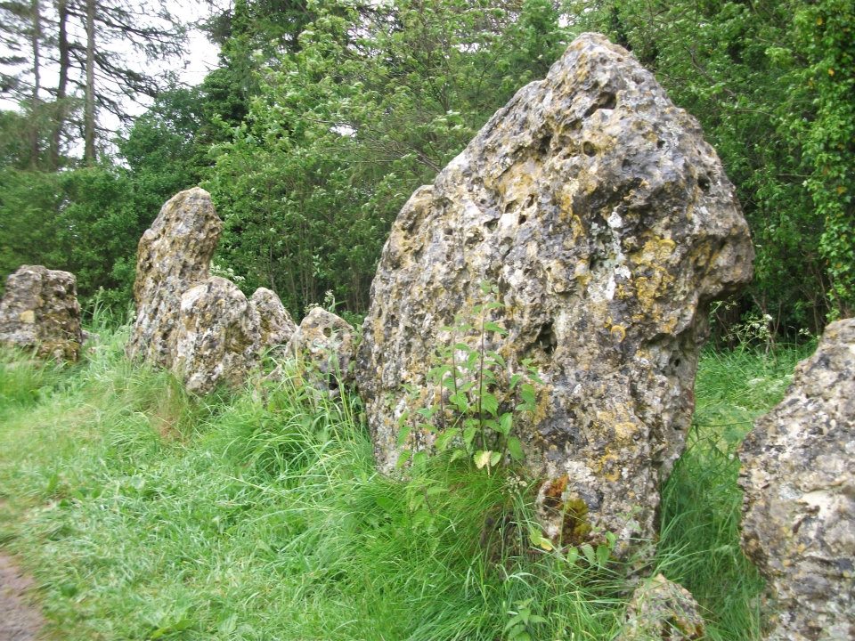
Southern arc of stones
There’s masses to be said on this site, which can’t possibly be added all in one go (I’ve literally got a full unpublished book on the many aspects of this lovely site) — so this entry will be updated occasionally with additional bits and bats of info and images as time floats by.
This remarkable and quite atmospheric megalithic complex has so much to say for itself that entire books have been written on the place (see the extensive references below), dealing with its archaeology, folklore and ritual use. I was very fortunate around the turn of the 21st century, to be able to live in an old hut that used to stand in the copse of trees just outside the circle, where I had numerous weird and wonderful experiences with people, wildlife, and what some might call the more eosteric life of the place…
1920s Ground-planMr Taunt’s 1907 plan
The King’s Men is a near-perfect circle of oolitic limestone uprights. Thought for centuries to be the memorial site of some victory by the Danish King Rollo, they have been described by many historians, travellers and antiquarians from the 14th century upwards. Several early writers described a sort of “avenue” running from the circle, not unlike the one perceived at Stonehenge and elsewhere. Evidence for this cannot be fully disregarded, as there are some recumbent monoliths along the road beside the stone complex, known as the Jurassic Way. This was a prehistoric trade route and it is more likely than not that some other uprights would have been nearby.
The Rollright Stones were used as the prime base for what was known as the Dragon Project: an exploratory examination of potential electromagnetic anomalies that were recorded at the standing stones here by scientists, geomancers and archaeologists who were involved daily monitoring work over many years. Much of this was published in Paul Devereux’s book, Places of Power – required reading for everyone who pretends an interest in megalithic sciences.
Northern section of the ring
The Rollright complex today consists primarily of three sites: the Whispering Knight’s portal dolmen, the King’s Men stone circle, and the King Stone. Of these, it is the stone circle which draws most attention. Several alignments are connected with the complex. The original ritual use of the place would have, primarily, involved rites of passage and death rituals; though it seems obvious that menstrual rites were also an important social event here. After dark, this stone circle has distinctly ‘female’ spirit, sometimes manifesting in a quite wrathful form (please don’t confuse any of the modern witchcraft mythos with such things – they are fundamentally different in both social and ritual aspects). Women obviously played a large part in the ritual use and geomantic layout of the original complex. It also seems likely that the stone circle was used as a moot spot, which may have been in use until medieval times. The recent discovery of the carving of a family crest, at least 500 years old, implies this.
Until Tom Wilson and I lived in the hut at the circle in the 1990s, previous reports of ‘carvings’ at the stone circle were few and debatable. But two of the stones in the Rollright circle have quite distinct carvings on them. The most pronounced is etched on the tallest stone (stone 1 – Barnatt Survey) and comprises of a typical heraldic shield – although we cannot, as yet, ascertain the motif in the middle of the shield. This was first seen by a visiting tourist who wanted to remain anonymous, but the finding was written up in an article I wrote shortly afterwards. (Bennett 1999) The image below – reproduced courtesy of Alistair Carty’s Archaeoptics Limited laser scanning company – clearly shows the carving, which confirmed the initial discovery. The report of his findings can be read here.
Not unsurprisingly, since the discovery of the shield various screwy interpretations have been put forward to account for the design. My favourite has to be the one suggested by a pagan friend of the Rollright Trust, who, occult-like and all secret (y’ get the drift) reckoned it was all to do with King Arthur! Needless to say, my response of, “Y’ talking bollox mate!” was received somewhat nervously by pagan Karin Attwood and the twee little entourage who were discussing the shield, in the usual ‘secrecy – secrecy’ hush-hush tone of false witches and similar idiots!
A few months later I found another set of carvings on stone 62 (Barnatt survey), comprising a set of Ogham letters. These Ogham are very faint and are best observed before midday, when lighting conditions highlight them much clearer. If anyone can decipher them, it would be greatly appreciated. (though please don’t gimme some shit about King Arthur)
Folklore
Folklore ascribes that the number of stones in the complex cannot be counted (a motif found at other megalithic sites) and, intriguingly, of the surveys done here, no two are the same! One early illustration of the circle shows 30 stones, nother describes 46, and one survey describes just 22 stones! As the 20th century progressed the numbers increased dramatically, with surveys differing at 58, 60, 71, 72, 73, 77 and 105. The present-day ‘guesstimate’ is about 77. Weird!
Folklore tells that if you can count the stones three times in a row and get the same number, you may have any wish you choose. But recently this has become reversed and it is said to be a curse if you count three times the same. Intriguingly, modern visitors who allege no superstitious beliefs, will not count the stones a third time if the same number crops up twice.
The best-known folk tale of this place is of the King, his men and the knights, who “were once men who were changed into vast rocks and fossilised,” as Camden first put it in 1586. The King’s men sometimes go to drink at a well near Little Rollright, as does the king, but he only goes at certain times. At midnight however, on certain days, the King’s Men have sometimes been known to come to life, join hands and dance in a circle. This sounds more like a folk remnant of ritual use here.
Faerie folk are said to live beneath the circle, in great caverns, some of which are linked up to the single monolith across the road. Ravenhill [1926] described how local folk had sometimes seen the little people dancing around the circle by moonlight, but nobody has seen them of late.
References:
Anonymous, The Rollright Stones: Theories and Legends, privately printed, n.d.
Anonymous, ‘Oxfordshire Mysteries,’ in The Ley Hunter 86, 1979.
Aubrey, John, Monumenta Britannica, Milbourne Port 1980.
Barnatt, John, Stone Circles of Britain (2 volumes), BAR: Oxford 1989.
Bennett, Paul, ‘Remarkable Carving found at the King’s Men Stone Circle, Rollright, Oxfordshire,’ in Right Times 5, 1999.
Bennett, Paul & Wilson, Tom, The Old Stones of Rollright and District, Cockley Press: London 1999.
Bloxham, Christine, Folklore of Oxfordshire, Tempus 2005.
Bord, Janet & Colin, The Secret Country, Paul Elek: London 1976.
Bord, Janet & Colin, A Guide to Ancient Sites in Britain, Paladin 1979.
Brooker, Charles, ‘Magnetism and the Standing Stones,’ in New Scientist, January 1983.
Burl, Aubrey, A Guide to the Stone Circles of Britain, Ireland and Brittany, New Haven & London 1995.
Burl, Aubrey, Great Stone Circles, Yale University Press: New York & London 1999.
Burl, Aubrey, The Stone Circles of Britain, Ireland and Brittany, Yale University Press 2000.
Clayton, Peter, Archaeological Sites of Britain, Weidenfeld & Nicolson: London 1976.
Cooper, Roy, ‘Some Oxfordshire Leys,’ in The Ley Hunter 86, 1979.
Cowper, B.H., ‘Oxfordshire Legend in Stone,’ Notes & Queries (1st series), 7, January 15, 1853.
Crawford, O.G.S., Long Barrows of the Cotswolds, John Bellows: Oxford 1932.
D., A.J., ‘Rollwright or Rollright,’ in Notes & Queries, 2nd series, 7, 1859.
Devereux, Paul, ‘Is This the Image of the Earth Force?’ in The Ley Hunter 87, 1979.
Devereux, Paul, ‘Operation Merlin,’ in The Ley Hunter 88, 1980.
Devereux, Paul, ‘Operation Merlin 2,’ in The Ley Hunter 89, 1980.
Devereux, Paul, ‘The Third Merlin,’ in The Ley Hunter 92, 1981.
Devereux, Paul, Places of Power, Blandford: London 1990.
Devereux, Paul, The Sacred Place, Cassell: London 2000.
Devereux, Paul, Steele, John & Kubrin, David, Earthmind, Harper & Row: New York 1989.
Devereux, Paul & Thomson, Ian, The Ley Hunter’s Companion, Thames & Hudson: London 1979.
Dyer, James, Discovering Regional Archaeology: The Cotswolds and the Upper Thames, Shire: Tring 1970.
Evans, Arthur J., ‘The Rollright Stones,’ in Trans. Bristol & Glouc. Arch. Soc., 40, 1892.
Evans, Arthur J., ‘The Rollright Stones and their Folklore (3 parts),’ in Folklore Journal, 1895.
Graves, Tom, Dowsing, Techniques and Application, Turnstone: London 1976.
Graves, Tom, Needles of Stone, Granada: London 1980.
Graves, Tom (ed.), Dowsing and Archaeology, Turnstone: Wellingborough 1980.
Gray, William, The Rollright Ritual, Helios: Cheltenham 1975.
Grinsell, Leslie V., The Ancient Burial Mounds of England, Methuen: London 1936.
Grinsell, Leslie V., The Rollright Stones and their Folklore, Toucan Press: Guernsey 1977.
Hamper, W., ‘Observations on certain Ancient Pillars of Memorial, called Hoar Stones,’ in Archaeologia, 25, 1833.
Hawkes, Jacquetta, A Guide to the Prehistoric and Roman Monuments in England and Wales, BCA: London 1973.
Higgins, Geoffrey, The Celtic Druids, Rowland Hunter: London 1829.
Krupp, E.C., In Search of Ancient Astronomies, Chatto & Windus: London 1979.
Lambrick, George, The Rollright Stones: The Archaeology and Folklore of the Stones and their Surroundings, Oxford Archaeology Review 1983. (Reprinted and updated in 1988.)


")


")


")

")