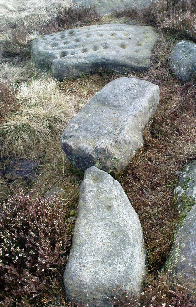
The Young Idol Stone (bottom) & parental Idol Stone above
Take the directions to reach the Haystack Rock, then head onto the moor following the south-east footpath for a few hundred yards, towards where the moor slopes uphill. 20-30 yards before the uphill slope, a yard to the right of the path, a couple of yards below the well-known Idol Stone carving – you’ll find it!
Archaeology & History
Described simply as a “small, rounded, smooth grit rock,” this long-tooth-shaped stone has just two cup-markings on its upper face: one on the more southern tip, and the second smaller cup several inches below it – as shown on the photo. The adjacent carving seen at the top of the photo is the parent guardian, Idol Stone! If you visit this, or any adjacent carvings here, please remember that all along this moorland plain are numerous unexcavated prehistoric tombs. You’re effectively stood at the edge of, or within, a huge prehistoric cemetery.
References:
Boughey, Keith & Vickerman, E.A., Prehistoric Rock Art of the West Riding, WYAS 2003.
Hedges, John, The Carved Rocks on Rombalds Moor, WYMCC: Wakefield 1986.
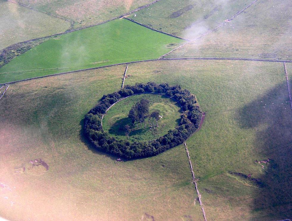
You can see the copse of trees here from all directions it seems, and there seem various ways in. Don’t think there’s a direct footpath, but from all accounts the locals are friendly and you can cross the fields from various directions. From either Pikehall to the north, Aldwark to the east, or Brassington from the south, head towards the distinct wooded copse atop of the hill and you’ll get there!
Archaeology & History
This superb-looking view catches the remains of at least two prehistoric tombs. In Marsden’s (1977) brief notes of the site he describes,
“Disturbed mound in plantation with exposed limestone cist. Primary cist rifled. Secondary cremation. A second barrow had been raised against the earlier cairn, containing a primary cremation in situ., with a burnt bronze razor, 2 flint knives and a bone tool.”
Barnatt & Collis (1986) give more detailed descriptions of the respective tombs. The first is categorized as a passage grave chambered cairn:
“This large but mutilated barrow measures c.45 x 38m and in parts is over 2m high. It had been much robbed for stone before the site was first recorded in the late 18th century. The ruined remains of four chambers can be seen. In 1843 Bateman located a fifth partially-collapsed chamber passage, now lost somewhere within the mound. Rooke recorded a further one of two structures to the north and possibly west sides of the mound (Douglas 1793), that had gone or been reburied in Bateman’s day. Small excavations by Marsden in 1973-4 clarified the design of the four visible chambers. Each originally had tall portals, back stone, side slabs, low septal slabs and short entrance passages. Drystone walling had been used to fill gaps between orthostats and in places to increase the heights of the sides.”
Although human remains were found here, the authors tell how the site was initially plundered as far back as the Romano-British period. It had once been a long cairn, aligned ENE-WSW, but they give no notice of any potential astronomical orientation (does anyone know?).
References:
Barnatt, John & Collis, John, Barrows in the Peak District, J.R. Collis: Sheffield 1986.
Bateman, Thomas, Vestiges of the Antiquities of Derbyshire, London 1848.
Douglas, J., Naenia Britannica, London 1793.
Marsden, Barry M., The Burial Mounds of Derbyshire, privately printed: Bingley 1977.
Tumulus (destroyed): OS Grid Reference – SD 7242 0899
Archaeology & History
This single-grave burial — described by Barnes (1982) as a kerbed or revetted cairn — close to the very centre of modern-day Bolton, was once an impressive prehistoric tomb. It was described by a local historian, Matthew Dawes, amidst a variety of prehistoric remains in and around Bolton, most of which have long-since been forgotten.
“Near Haulgh, about a quarter of a mile south-east from Bolton Parish Church, on a piece of high flat land, on the east bank of the Croal, and about fifty feet above the river, was a tumulus, about thirty feet in diameter, and four feet deep, consisting of small boulders… It was discovered in September, 1826, in forming a branch of the new road leading from Bolton to Bury. It was probably much depressed in its formation and was covered with a few inches of mound. The cop or fence crossed it in a north and south direction. About the centre of this tumulus was a cist-vaen, about four feet six inches long and one foot deep, formed of four upright stones and a coverer, and its length was nearly north and south. In this cist-vaen was a skeleton, with the legs doubled up, and the head to the north. Near the head, and on the west side, was found an urn, inverted, four and a half inches in the widest diameter, and three and a quarter inches high, and perforated by four small holes in the widest part. On the other side of the head was a bronze spear-head, four and three-eighths inches long, and one and three-eighths inch wide, of which the point was bent back, and a piece of the side chipped away. The urn and spear-head were taken to the Countess of Bradford, the Earl of Bradford being the owner of the land.”
Intriguingly, if you’re from the Bolton region, Mr Dawes also told that, “A man in the employ of the Earl of Bradford, the superintendent of the work, who made the discovery, informs me (1862) that two other tumuli were found shortly after the one just described, a few yards to the south of it, in the same fence.” As yet I have no more information about these other tombs (gimme time though!)
References:
Barnes, Bernard, Man and the Changing Landscape, Unversity of Liverpool 1982.
Dawes, M., ‘British Burial Places near Bolton,’ in Trans. Hist. Soc. Lancs & Cheshire, volume 4, 1852.
Scholes, James C., History of Bolton, Daily Chronicle: Bolton 1892.
Get to the Twelve Apostles stone circle, then walk just 100 yards down the main footpath south, towards Bingley, and watch out for a small footpath immediately to your left. Walk on here and head for the rocky outcrop a half-mile ahead of you. Once past the outcrop, take the first footpath right and walk down for another 100 yards. Stop! – and walk into the heather. The circle’s about 50 yards away! You can of course come from the Menston side of the moor, following the same directions for the Great Skirtful of Stones, but keep walking on for another 200 yards, towards the rocky outcrop again, turning left down the path for 100 yards, before stopping and walking 50 yards into the heath again!
Archaeology & History
Roms Law circle
This is one of my favourite sites on these moors. I’m not 100% sure why – but there’s always been something a bit odd about the place. And I don’t quite know what I mean, exactly, when I say “odd.” There’s just something about it… But it’s probably just me. Though I assume that me sleeping rough here numerous times in the past might have summat to do with it, playing with the lizards, and of course…the sheep… AHEM!!! Soz about that – let’s just get back to what’s known about the place!
Grubstones is an intriguing place and, I recommend, recovers its original name of Roms or Rums Law. It was described as such in the earliest records and only seems to have acquired the title ‘Grubstones’ following the Ordnance Survey assessment in the 1850s. The name derives from two compound words, rum, ‘room, space, an open space, a clearing’; and hlaw, a ‘tumulus, or hill’ – literally meaning here the ‘clearing or place of the dead,’ or variations thereof. But an additional variant on the word law also needs consideration here, as it can also be used to mean a ‘moot or meeting place’; and considering that local folklore, aswell as local boundary records tell of this site being one of the gathering places, here is the distinct possibility of it possessing another meaning: literally, ‘a meeting place of the dead’, or variations on this theme.
The present title of Grubstones was a mistranslation of local dialect by the Ordnance Survey recorders, misconstruing the guttural speaking of Rum stones as ‘grub stones.’ If you wanna try it yourself, talk in old Yorkshire tone, then imagine some Oxford or London dood coming along and asking us the name of the ring of stones! It works – believe me….
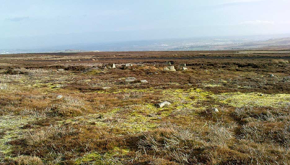
The site has little visual appeal, almost always overgrown with heather, but its history is considerable for such a small and insignificant-looking site. First described in land records of 1273 CE, Roms Law was one of the sites listed in the local boundary perambulations records which was enacted each year on Rogation Day (movable feast day in Spring). However in 1733 there was a local boundary dispute which, despite the evidence of written history, proclaimed the Roms Law circle to be beyond the manor of Hawksworth, in which it had always resided. But the boundary was changed – and local people thenceforth made their way to the Great Skirtful of Stones on their annual ritual walk: a giant cairn several hundred yards east to which, archaeologically, there is some considerable relationship. For at the northern edge of the Roms Law circle is the denuded remnants of a prehistoric trackway in parts marked out with fallen standing stones and which leads to the very edge of the great cairn. This trackway or avenue, like that at Avebury (though not as big), consists of “male” and “female” stones and begins – as far as modern observations can tell – several hundred yards to the west, close to a peculiar morass of rocks and a seeming man-made embankment (which I can’t make head or tail of it!). From here it goes past Roms Law and continues east towards the Great Skirtful, until it veers slightly round the southern side of the huge old tomb, then keeps going eastwards again into the remnants of a prehistoric graveyard close by.
In my opinion, it is very likely that this trackway was an avenue along which our ancestors carried their dead. Equally probable, the Roms Law Circle was where the body of the deceased was rested, or a ritual of some form occurred, before taken on its way to wherever. It seems very probable that this avenue had a ceremonial aspect of some form attached to it. However, due to the lack of decent archaeological attention, this assertion is difficult to prove.
A previously unrecognised small single tomb is in evidence to the immediate southeast (5 yards) of the circle. There is also another previously unrecognised prehistoric trackway that runs up along the eastern side of the circle, roughly north-south, making its way here from Hawksworth Moor to the south. The old legend that Roms Law was a meeting place may relate to it being a site where the dead were rested, along with it being an important point along the old boundary line. Records tell us that the chant, “This is Rumbles Law” occurred here at the end of the perambulation – which, after the boundary change, was uttered at the Great Skirtful. This continued till at least 1901.
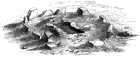
Northern section of the Ring
Modern archaeological analysis of the site is undecided as regards the actual nature of Roms Law. Ordnance Survey maps show it as an “enclosure” (which is vague); Faull & Moorhouse’s survey (1981) erroneously tell us it had no funerary nature, contrary to Eric Cowling’s (1946) report of finding bones and ashes from the small hole in near the centre of the ring, aswell as the 1880 drawing of the site in Collyer & Turner’s survey (above). And we find the single cairn on the south-eastern edge of the ring indicating burial rites of sorts definitely occurred here. Described variously by previous archaeologists as a stone circle, a ring cairn, cairn circle, an enclosure, aswell as “a rubble-fill wall of a circular house” (by some anonymous member of the West Yorkshire Archaeology Service, who didn’t respond to my queries about this curious assumption), the real nature of Roms Law leans more to a cairn circle site. A fine example of a cup-and-ring stone — the Comet Stone — was found very close to the circle, somewhere along the Grubstones Ridge more than a hundred years ago, and it may have had some relevance to Roms Law.
This denuded ring of stones is a place that has to be seen quite blatantly in a much wider context, with other outlying sites having considerable relationship to it. Simple as! (If you wanna know more about this, check out my short work, Roms Law, due out shortly!)
Describing the status and dimensions here, our great Yorkshire historian Arthur Raistrick (1929) told that:
“The larger stones still standing number about twenty, but the spaces between them are filled with stones of many intermediate sizes, so that one could with only considerable detail of size, etc, number the original peristalith.”
…Meaning that we’re unsure exactly how many stones stood in the ring when it was first built! Although a little wider, the Roms Law is similar in form to the newly discovered ‘Hazell Circle‘ not far from here. The site has changed little since Raistrick’s survey, though some halfwits nicked some of the stones on the southwestern edge of the site in the 1960s to build a stupid effing grouse-butt, from which to shoot the birds up here! (would the local council or local archaeologist have been consulted about such destruction by building the grouse-butt here? – anyone know?) Thankfully, this has all but disappeared and the moorland has taken it back to Earth.
There is still a lot more to be told of Roms Law and its relationship with a number of uncatalogued sites scattered hereby. Although it’s only a small scruffy-looking thing (a bit like misself!), its archaeology and mythic history is very rich indeed. “Watch This Space” – as they say!
Folklore
Alleged to be haunted, this site has been used by authentic ritual magickians in bygone years. It was described by Collyer & Turner (1885) “to have been a Council or Moot Assembly place” — and we find this confirmed to a great extent via the township perambulation records. Considerable evidence points to an early masonic group convening here in medieval times and we are certain from historical records that members of the legendary Grand Lodge of All England (said to be ordained in the tenth century by King Athelstan) met here, or at the adjacent Great Skirtful of Stones giant cairn 400 yards east.
The boundary perambulations which occurred here on Rogation Day relate to events just before or around Beltane, Mayday. Elizabeth Wright (1913) said of this date:
“These days are marked in the popular mind by the ancient and well-known custom of beating the parish bounds, whence arose the now obsolete name of Gang-days, and the name Rammalation-day, i.e., perambulation-day, for Rogation-Monday. The practice is also called Processioning and Possessioning… The reason why this perambulation of the parish boundaries takes place at Rogationtide seems to be that originally it was a purely religious observance, a procession of priest and people through the fields to pray for a fruitful Spring-time and harvest. In the course of time the secular object of familiarizing the growing generation with their parish landmarks gained the upper hand, but the date remained as testimony to the primary devotional character of the custom.”
And the calling of, “This is Rumbles Law” maintained this ancient custom when it used to be uttered here.
The grid reference here is an approximation, but the old well was definitely somewhere very close by, as evidenced by the place-name of the farmhouse. But if you wanna get here and wander about in the hope that you can re-locate this once sacred water source, go up the B1269 road north of Guisborough for about a mile. Carling Howe farmhouse is on the left-hand side of the road. Obviously the old well is somewhere close by…
Archaeology & History
The information I have of this site comes from old place-name listings. I found the reference in the directory for North Yorkshire by A.H. Smith (1928), in his entry for the etymology of ‘Carling Howe’ at Guisborough. Smith ascribes the references of ‘Kerlinghou’ (which itself appears to have been lost) to mean the ‘Old woman’s mound’ and variants thereof, also saying, “There is an unidentified place in this township called Kerlingkelde,” (12th century ref. Guisborough Cartulary)—the ‘Old Woman’s Well’. Very commonly in this part of Yorkshire—as at many other locations in northern England—a hou or howe (and variants thereof) relates to a prehistoric tomb – which is probably what we had here: a prehistoric Old Woman’s Grave with an associated Old Woman’s Well in close attendance.
The ‘old woman’ element in this name very probably relates to that primal mythic deity, the cailleach, the great prima mater of indigenous heathen folk, beloved mainly in Scottish and Irish lore, where her copious name and tales resonate to this day. This “well of the Old Woman, or cailleach“, would have been a place of particular importance in the mythic cosmology of our ancestors, but its precise whereabouts seems forgotten. There is a plentiful supply of water around Carling Howe Farm, one or more of which may once have been the site of this well. However, a lot of quarrying operations occurred here in the not-too-distant past, and this may have irreparably damaged our ability to accurately find the site – though perhaps a perusal of old field-maps could be productive.
It would also be good if we could locate the original whereabouts of the old tomb here which gave the place its name – the ‘Carling Howe’. Other ‘howe’ sites in East and North Yorkshire turn out to be prehistoric burials and I have little doubt that the same occurred here.
References:
o’ Crualaoich, Gearoid, The Book of the Cailleach, Cork University Press 2003.
Smith, A.H., The Place-Names of the North Riding of Yorkshire, Cambridge University Press 1928.
When the Scottish Royal Commission lads came here in 1963, they reported seeing
“the remains of a short cist…set into the west side of a small turf-covered knoll some 18 metres north of the schoolhouse at Ardminish.”
It was first found during quarrying operations here, and was thankfully kept pretty well preserved, apart from the western slab, which was dislodged and fell to the foot of the knoll. The cist aligns roughly north-south (the airt, or cardinal virtue of ‘death’ is north) and measured about 3 feet long by 2 feet wide.
References:
Royal Commission on the Ancient & Historical Monuments, Scotland, Argyll: volume 1 – Kintyre, HMSO: Edinburgh 1971.
Stone Circle (destroyed): OS Grid Reference – SE 138 403
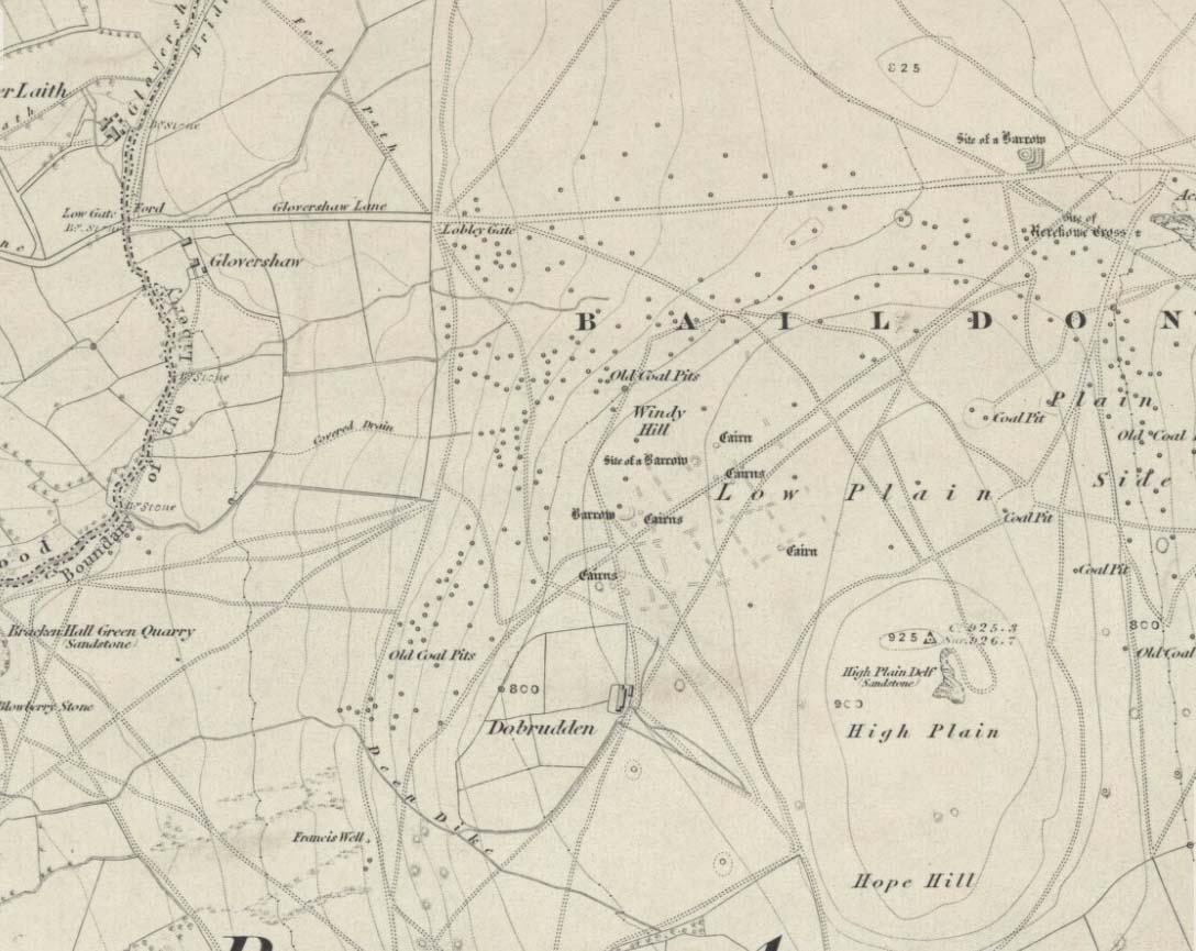
Windy Hill on 1852 map
Archaeology & History
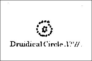
The early northern antiquarian, J.N.M. Colls (1846), described visiting a ‘druidical circle’ of stones due east of the Dobrudden prehistoric graveyard, but it seems to have been completely destroyed soon after he wrote his essay, with the stones taken away for use in road-building. He told that here was,
“a double circle of stones, the outer ring numbering eighteen, with six stones making up the inner circle.”
…and his illustration shows just that! It’s possible that this inner ring may have covered a burial. Harry Speight — aka, ‘Johnnie Gray’ (1891) — is the only other writer I’ve found that refers to the megalithic remains up here, although he gave no additional details.
Windy Hill Circle (after Colls, 1846)
The site was to be found across the High Plain and Windy Hill, on the western edge of Baildon Hill, where there was once a greater profusion of seemingly neolithic and Bronze Age remains. Another possible early reference to the site is in Collyer & Turner’s Ilkley (1885), where they talk of a circle “on the highest part of the eastern moor,” fifty-six feet across with a similar appearance to the Pennythorn Hill circle, although they describe it as overlooking the hamlet of Sconce, which is hardly possible from the Windy Hill side of Baildon Moor.
The site looked across the horizon from south, through west to north and if used astronomically would have been used to observe sun and moonset times. Although we find a number of cup-and-ring stones in the vicinity, it really does seem that this site has bit the dust!
References:
Bennett, Paul, The Old Stones of Elmet, Capall Bann: Chieveley 2001.
Colls, J.N.M., ‘Letter upon some Early Remains Discovered in Yorkshire,’ in Archaeologia 31, 1846.
Collyer, Robert & Turner, J. Horsfall, Ilkley, Ancient and Modern, William Walker: Otley 1885.
Gray, Johnnie, Through Airedale, from Goole to Malham, Elliot Stock: London 1891.
Although apparently long gone, we could find this giant prehistoric tomb on the eastern side of the great Ingleborough and was one of many with this name once scattering the mid-Pennines. It was found less than a mile south of the hamlet of Selside, a few miles above Horton-in-Ribblesdale, on the west side of the B6479 and its existence is thankfully preserved in the place-name, ‘Borrens’, where the giant tomb was once found, 200 yards south of Gill Garth Farm. If you look on the OS-map, you’ll notice an ancient settlement site close by.
Archaeology & History
In 1892, the great Yorkshire historian Harry Speight told us:
“We have no proper account of it, but it was doubtless ransacked and removed in the expectation of finding treasure. It is mentioned…in the Gentleman’s Magazine for 1761, as follows:
‘In the valley above Horton, near the base of this mountain (Ingleborough), I observed a large heap or pile of greet-stones all thrown promiscuously together, without any appearance of building or workmanship, which yet cannot be reasonably thought to be the work of Nature. Few stones are found near it, though ’tis computed to contain 400 of that country cart-loads of stones, or upwards. There is likewise another at the base north-east, in resemblance much the same, but scarce so large.'”
Speight speculated that it may have been raised to commemorate “some dire conflict between the Romans and the native hill tribes, as it lay on the old Roman thoroughfare across Ribblehead to the camp under Smearside.” We may never know this for sure, but there are plenty of Iron- and Bronze Age remains scattering this region – and just a few hundred yards south of this lost cairn are the old remnants of an ancient settlement…whose pages and images (it is hoped) will appear on TNA in the near future…
References:
Smith, A.H., English Place-Name Elements, volume 1, Cambridge University Press 1956.
Smith, A.H., Place-Names of the West Riding, volume 6, Cambridge University Press 1961.
Speight, Harry, The Craven and Northwest Yorkshire Highlands, Elliott Stock: London 1892.
Pretty simple really. Go up the B6265 Skipton-Rylstone road for about 3 miles, past the Nettlehole Ridge woodland on your right. The next turn along to your right, up the track, is Scale House. Go past this until you get to Scale House Farm. The remains of the burial mound is in the field to your left, just before the farm. Knock on the door and ask!
Archaeology & History
This ‘tumulus’ (as it’s marked on the OS-map) was one of the many explored by the legendary reverend William Greenwell (1864) in the middle to latter-half of the 19th century. His description of the finds at Scale House were considerable; thankfully our old Yorkshire antiquarian Edmund Bogg (1904) shortened it and told us the following:
“The tumulus was 31 feet in diameter and about 7 feet high; it opened from the southeast; the soil immediately under the sod consisting of yellow clay to a considerable depth; then layers of blue clay… Exactly in the centre…at a depth of 7 feet, and on a level with the plane of the field, was found an oak coffin, formed out of a tree, split and hollowed-out, and placed due north and south, the head being placed to the south, as that as the larger part of the tree. After being exposed to the air for about 2 minutes, the bared coffin parted at the sides, and could not be moved except by detached pieces. The body had been wrapped in a cloth or shroud of texture resembling wool and coarsely-woven, of which there was a considerable quantity remaining; but the body itself was dissolved… The interment was considered to be that of an ancient Briton… The learned antiquary said it was the only instance (except the one at Gristhorpe, near Scarborough) where an interment in an oak tree hollowed out had a tumulus placed over it. It was more than 6 feet in length inside and about 7 feet 6 inches outside. The remains were carefully replaced and the mound restored to its former shape; a small leaden tablet being placed within, stating that it had been opened in AD 1864.”
Folklore
Jessica Lofthouse (1976) listed this as one of the places reputed to be an old fairy haunt, wherein “the folk of Scale House discovered a fairy kist or chest.”
References:
Bogg, Edmund, Higher Wharfeland, James Miles: Leeds 1904.
Greenwell, William, British Barrows, Clarendon Press: Oxford 1877.
Lofthouse, Jessica, North Country Folklore, Hale: London 1976.
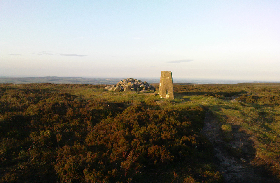
This is the highest point of the moors, 1320 feet up. There’s various ways of getting there: I’d favour the wander up to Twelve Apostles then taking the 15 minute walk west to the triangulation point which marks the spot. If you reach the large rocky outcrop of the Thimble Stones, you’ve gone too far; although you can walk past the Thimbles, if you’ve started your walk from the two radio masts atop of the moor where the old Roman road hits the dirt-track. Either way, unless you’re damn stupid, this is an easy spot to find!
Archaeology & History
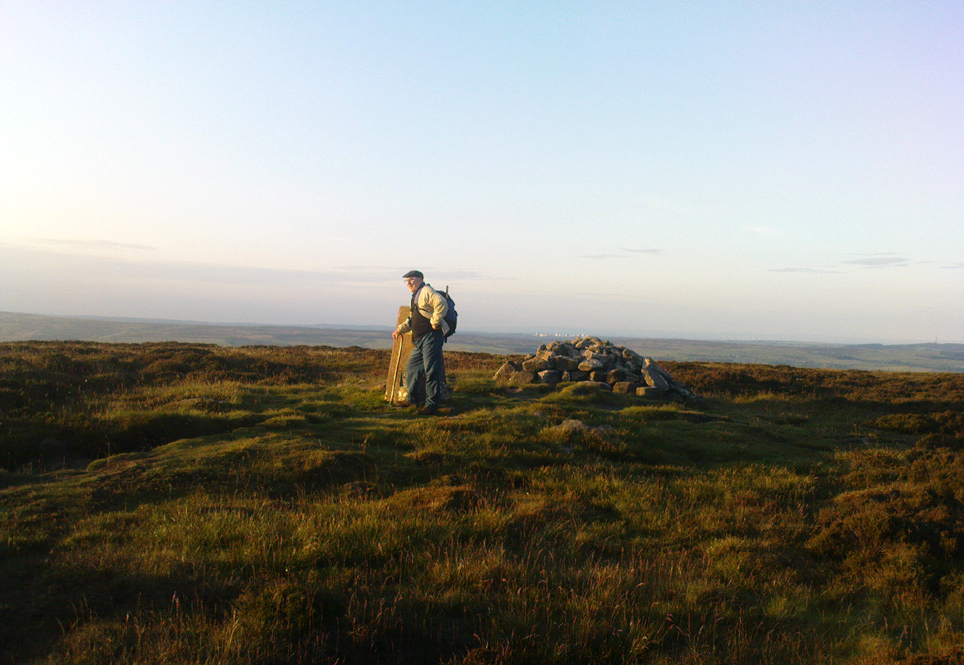
Although today there’s little to be seen, when Collyer & Turner (1885) described the place it was 175 yards in circumference! Bloody huge! When Harry Speight got here in 1900, it had shrunk slightly to 150 yards. Now however, almost all the stones have been robbed. I first came here when I was just 11 years old and remember it was a decent size even then – at least as large as the Little Skirtful and Great Skirtful of Stones more than a mile to the east. Today however, unless you knew it was once a giant cairn, you wouldn’t give it a second look.
It’s quite appalling what’s happened to this site thanks to the sheer ignorance and neglect of the local archaeologist in tandem with his paymasters at Bradford Council: 90% of the site has been utterly vandalised and destroyed as a result of these incompetent idiots in the last 20 years. Nowadays, all you can make out here is the raised earth for about 10 yards surrounding the trig-point. It seems that most of the stones that comprised this giant cairn have been taken for use in walling, and to prop up the stupid paved footpaths which the local Council and its affiliated halfwits are slowly building o’er these hills.* Morons!
Aar Dave on top o’ t’ moors
I’m not quite sure why it was called Nixon’s Station. It was J. Atkinson Busfield (1875) who mentioned this name, quite casually in his fine local history work, as if local folk had known it as such for sometime. There was also an inference of it being the resting place of some old general, but I’ve found nor heard anything more along such lines — though worra superb place for your spirit to roam free…..
If anyone has any old photos of this once giant prehistoric site, it would be good to see it in its old glory once again. When I wandered up here as a kid, I never carried things like a camera about (being a Luddite by nature!).
References:
Busfield, J.A., Fragments Relating to the History of Bingley Parish, Bradford 1875.
Collyer, R. & Turner, J.H., Ilkley, Ancient & Modern, Otley 1885.
* Anyone know exactly which idiots are responsible for the stone footpaths being laid over the moors here? They’re damn stupid and cause even more erosion and damage to the environment and prehistoric heritage up here, as anyone with an ounce of common sense can see. Can someone please get them stopped!?