Baildon Moor (126), West Yorkshire

Cup-Marked Stone:  OS Grid Reference – SE 13066 40095

Also Known as:

  1. Carving no.9 (Hedges)
  2. Central Design Stone

Getting Here

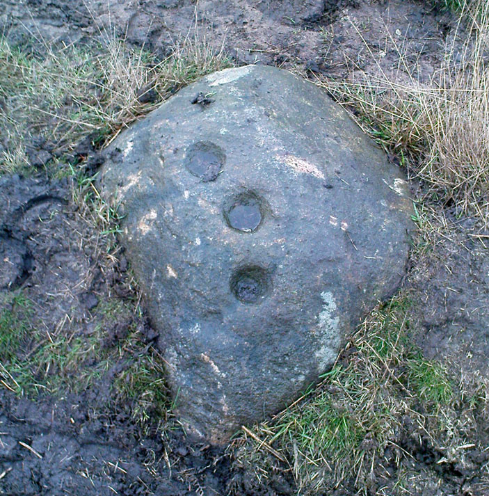
Arc of deep cups

From the old Glen House pub, walk up the road onto ‘Shipley Glen’ as all locals call the place.  Go up the Glen Road for about half a mile, watching out for the small dirt-track turning going the slope on your left-hand side just near where the road starting swerving uphill to the right.  At this point where the track heads down and into the trees, there’s a footpath going into the bracken along to the right, heading onto level ground.  Walk up and along here.  After 100 yards or so you’ll notice the disused quarry on your left.  Keep walking along the footpath (two end up running parallel to each other) and you’ll see this carving right beneath your feet!

Archaeology & History
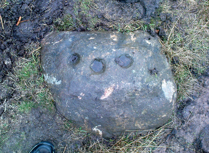
Baildon Moor carving 126

This was one of the very first examples of “cup and ring stones” that I ever saw, when I was a mere 10 or 11 years old!  I’m not quite sure what I expected to find, but something about this stone with its deeply set cup-markings obviously had an effect on me – as I’m still foraging about looking at them more than 35 years later!  About 20 yards away from the Glovershaw quarry carving (Baildon Moor 122), this central design stone — as I used to call it — was first recorded in W. Paley Baildon’s (1913) magnum opus and was then all-but-forgotten until the Bradford Archaeology Group mentioned it again more than forty years later.  Although you can only see three distinct cups on this small rock, another 2 or 3 seem in evidence under better lighting conditions, and a small line runs below the cups in the photo here, which you can just make out above the central cup.

This carving and others close by give the distinct impression that they were once part of some seemingly lost cairn-field, awaiting rediscovery…

References:

  1. Baildon, W. Paley, Baildon and the Baildons – parts 1-15, Adelphi: London 1913-1926.
  2. Bennett, Paul, Of Cups and Rings and Things, unpublished: Shipley 1981.
  3. Bennett, Paul, Megalithic Ramblings between Ilkley and Baildon, unpublished: Shipley 1982.
  4. Boughey, Keith & Vickerman, E.A., Prehistoric Rock Art of the West Riding, WYAS: Leeds 2003.
  5. Cowling, Eric T., Rombald’s Way, William Walker: Otley 1946.
  6. Hedges, John, The Carved Rocks on Rombald’s Moor, WYMCC: Wakefield 1986.

© Paul Bennett, The Northern Antiquarian


Carlowrie, Kirkliston, Midlothian

Cup-and-Ring Stone (destroyed):  OS Grid Reference – NT 138 746

Archaeology & History

Lost carving of Carlowrie

Two-thirds of a mile west of the Cat Stane, on land immediately north of the River Almond by Edinburgh Airport in an area that was reported in 1780 to be “filled with the skeletons of human bodies,” this old petroglyph could once be found.  The Scottish Royal Commission (1929) described it as being a covering stone for a short prehistoric tomb near the OS-grid reference cited here, “but when discovered it was much broken by the plough that it does not appear to have been preserved.”  They refer instead to the last report of the site in the Scottish Society of Antiquaries journal, where we were informed that the cover stone was,

“marked with three series at least of concentric circles… The widest diameters of the sets of rings cut on the inside of the lid is about five inches, and each set is composed of five concentric circles.”

All trace of this carving appears to have been lost.  Other carvings reported nearby in the 19th century also appear to have been lost or destroyed.

References:

  1. Morris, Ronald W.B., The Prehistoric Rock Art of Southern Scotland, BAR 86: Oxford 1981.
  2. Royal Commission on Ancient & Historical Monuments, Scotland, Midlothian and Westlothian, HMSO: Edinburgh 1929.
  3. Simpson, J.Y., The Cat-Stane, Edinburghshire, Neill & Co: Edinburgh 1862.
  4. Simpson, J.Y., “On Ancient Sculpturings of Cups and Concentric Rings,” in Proceedings of the Society of Antiquaries, Scotland, volume 6, 1864-66.

© Paul Bennett, The Northern Antiquarian

Bel Stane, Causewayhead, Stirling, Stirlingshire

Standing Stone (destroyed?):  OS Grid Reference – NS 805 958

Archaeology & History

Nearly a hundred years ago Christina Buchan told the local writer Donald Morris (1935) about this seemingly forgotten and lost megalithic site.  The narrative she gave told:

“I remember a stone which was known among the Causewayhead people as the Bel Stane. (The name is significant)  It originally stood in the Doocot Park on Spittal Farm.  This park overlooks the high road from Causewayhead to Bridge of Allan and adjoins the steading of Spittal… When the road leading up through the village of Causewayhead was formed (about 1820), the garden of William Robb’s cottage near the foot of the Broad Loan was somewhat altered in shape.  He put up a new gate and, requiring a gatepost, he lifted the Bel Stane from Doocot Park and set it up at the front of his own house to support the gate.  It was a stone of pillar-shape and stood four or five feet above the ground, and I do not remember whether they were any markings on it.  The cottage became ruinous many years ago and the garden ran waste.  A new house is now built on the site, but the Bel Stane has been lost.”

There is a possible contender for the lost Bel Stane, used again as another gatepost, on the south-side of the road some 450 yards to the east (at NS 80922 95931).  The stone in question is somewhat fatter than usual gateposts, about four-feet tall, and has the eroded appearance of considerably greater age than many others.  The monolith isn’t mentioned in the Royal Commission’s Stirlingshire inventory. Further information would be very welcome.

References:

  1. Morris, David, B., ‘Causewayhead a Hundred Years Ago’, in Transactions of the Stirling Natural History and Archaeological Society, 1935.

© Paul Bennett, The Northern Antiquarian

Pathfoot Stone, Airthrey, Stirling, Stirlingshire

Standing Stone:  OS Grid Reference – NS 80604 96871

Also Known as:

  1. Airthrey Castle West
  2. Canmore ID 47166

Getting Here

Not too troublesome to locate really… It’s at the top-end of the University, just above the side of the small Hermitage Road, about 100 yards along.  Keep your eyes peeled to your left!

Archaeology & History

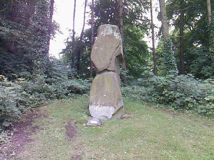
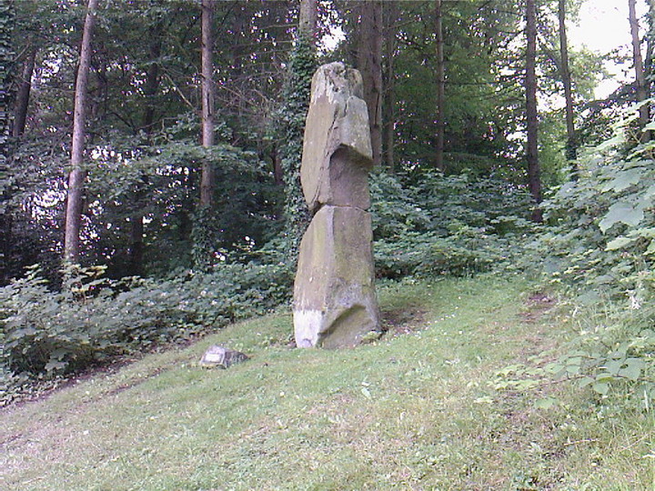
Pathfoot Stone

Today standing proud and upright, this ruinous standing stone has been knocked about in the last couple of hundred years.   Although we can clearly see that it’s been “fixed” in its present condition, standing more than 10 feet high, when the Royal Commission lads came here in August 1952 (as they reported in their utterly spiffing Stirlingshire (1963) inventory), it wasn’t quite as healthy back.  They reported:

“Many years ago the stone, which is of dark grey dolerite, fell down and was broken, and the basal portion, now re-erected, is only 3ft 10in high; two large fragments however, still lie beside the base, and the original stone is said to have stood to a height of 9ft 4in.  Of a more or less oblong section throughout, the re-erected stones measures 2ft 10in by 1ft 10in at ground level, swells to its greatest dimensions (3ft 2 in by 1ft 9in) at a height of 1ft 4in, and diminishes at the top…”

…and again!

But the scenario got even worse, cos after the Royal Commission boys had measured it up and did their report, it was completely removed!  Thankfully, following pressure from themselves and the help of the usual locals, the stone was stood back upright in the position we can see it today.  And — fingers crossed — long may it stay here!

Folklore

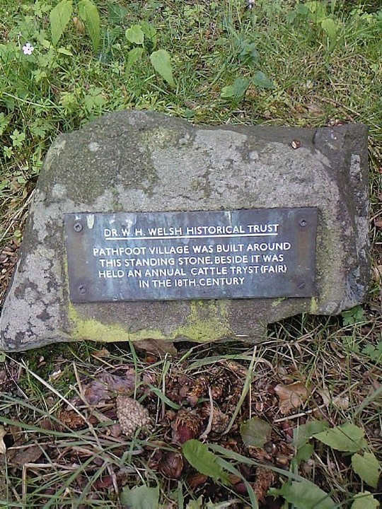
Commemorative plaque!

A plaque that accompanies the monolith tells that the old village of Pathfoot itself was actually “built around this standing stone” — which sounds more like it was the ‘centre’ or focus of the old place.  An omphalos perhaps?  The additional piece of lore described in Menzies (1905) work, that an annual cattle fair was held here,  indicates it as an ancient site of trade, as well as a possible gathering stone: folklore that we find is attributed to another standing stone nearby.

References:

  1. Fergusson, R. Menzies, Logie: A Parish History – volume 1, Alexander Gardner: Paisley 1905.
  2. Hutchinson, A.F., “The Standing Stones of Stirling District,” in The Stirling Antiquary, volume 1, 1893.
  3. Hutchinson, A.F., “The Standing Stones and other Rude Monuments of Stirling District,” in Transactions of the Stirling Natural History and Antiquarian Society, 1893.
  4. Royal Commission on the Ancient and Historical Monuments of Scotland, Stirlingshire – volume 1, HMSO: Edinburgh 1963.

© Paul Bennett, The Northern Antiquarian

Studfold Ring, Ampleforth, North Yorkshire

Enclosure / Settlement:  OS Grid Reference — SE 58122 79855

Also Known as:

  1. Studford Ring

Getting Here

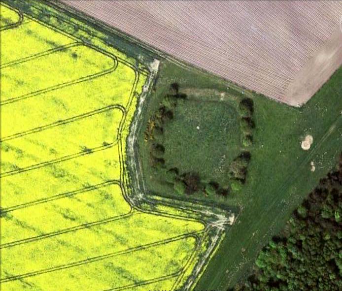
Studfold Ring from above

Pretty easy to find.  From Ampleforth town centre, go left at the T-junction and 100 yards on a footpath takes you up into the sloping fields above the town. Follow the footpath up (avoiding the fall into the small wooded valley on your left) and keep going across the fields. Follow the path towards the point of the woodland on the level, then walk along its edge until you see a rounded copse of trees on your left, with a surrounding ditch. You’ve found it! (if you hit the road, turn back & walk 100 yards)

Archaeology & History

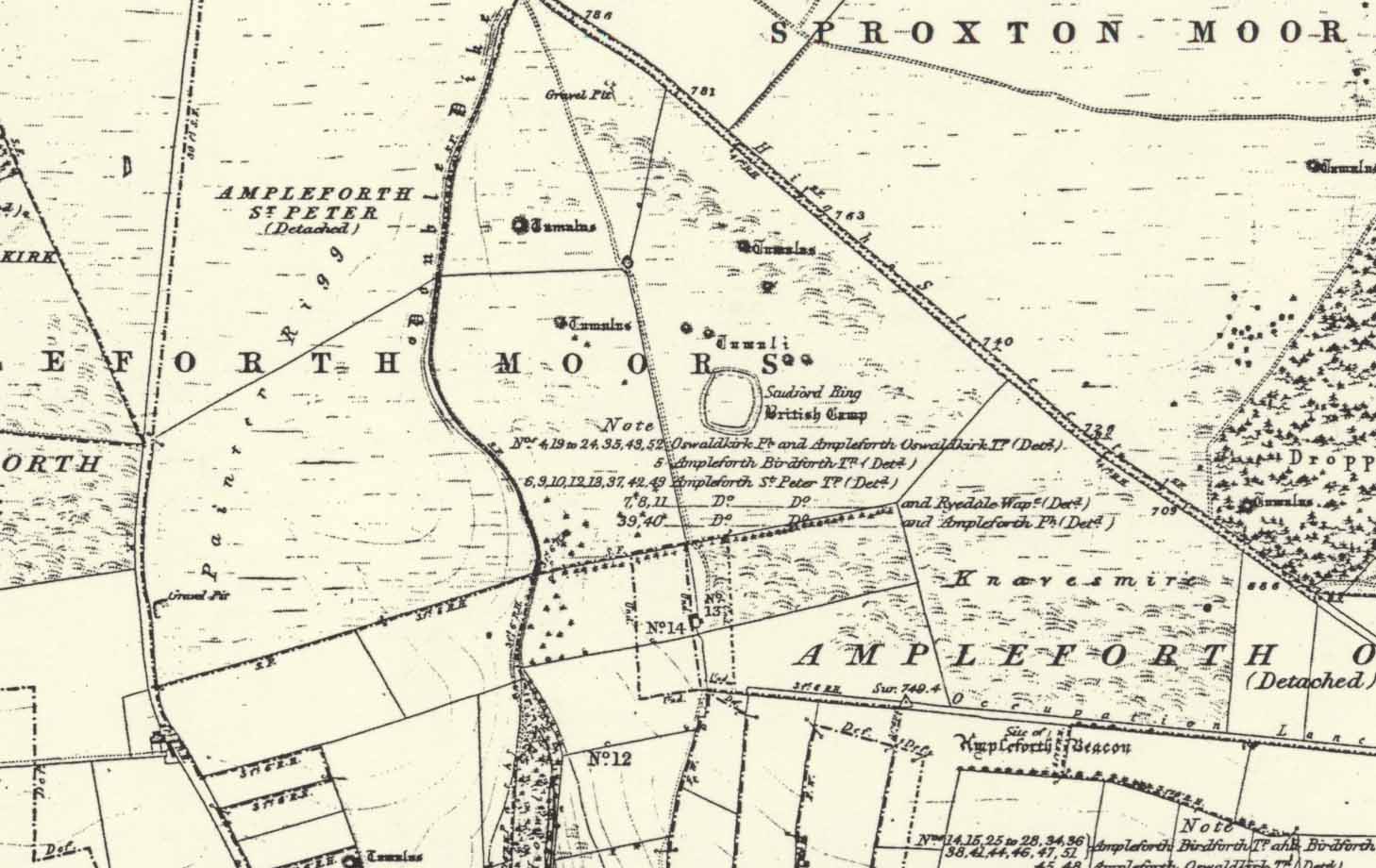
Thought to have been first constructed in the late Bronze Age period, in 1963 R.H. Hayes described this site as being “the finest enclosure type of earthwork in the district,” telling:

“It is roughly quadrangular, some 54 yards across, rampart to rampart, with internal ditch 12ft wide and in places still 4ft in depth. The rampart is 24-26ft wide and 9-10ft high above the bottom of the ditch. It is of earth and rubble with an entrance 9ft wide on the ESE. One gets the impression that the central area is a araised platform above the level of the surrounding moor.”

Studfold Ring on 1856 OS-map

At the time of Hayes’ description, conclusions about the purpose of this site were difficult. He drew parallels between this and two other sites in northeast Yorkshire: one on Great Ayton Moor and another near Borrowby on Newton Mulgrave Moor.

On the outside of the ‘enclosure’ he described “a curious turf (?) bank 6ft wide and 2ft high which curves around the tumuli to the northeast, following the ditch of one of them, thence to another mound 32ft in diameter north of the Ring, whence it turns due west and runs towards a dewpond in the junction of three turf walls,” finally adding, “It could be connected with ancient cultivation.”

According to Eilert Ekwall (1922), the name Studfold probably derives from,

“‘Stodfalod’, which is a common name for old Roman (or other) enclosures. The name indicates that the Anglo-Saxons often used such old enclosures for horsefolds.”

Place-name master A.H. Smith (1956) reinforces this and tells us the dates of this name are even later; describing,

“stod-fald OE, ‘a stud-fold, a horse enclosure’; the word is often applied to ancient enclosures which the Anglo-Saxons used for horse-folds.”

Modern archaeo’s have added the etymologist’s notion of a ‘horse enclosure’ onto their summaries of the site in recent years.

…to be continued…

References:

  1. Ekwall, Eilert, The Place-Names of Lancashire, Manchester University Press 1922.
  2. Hayes, R.H. ‘Archaeology: Dikes and Earthworks,’ in J. McDonnell’s A History of Helmsley, Rievaulx and District, Stonegate Press: York 1963.
  3. Smith, A.H. English Place-Name Elements, II, Cambridge University Press 1956.
  4. White, Stanhope, The North York Moors: An Introduction, Dalesman: Clapham 1979.

Acknowledgements:  Huge thanks to Martin Dawes for correcting my initial erroneous route to the site.

© Paul Bennett, The Northern Antiquarian 

Leathad Carnaich, Dalhalvaig, Caithness

Cairn:  OS Grid Reference – NC 89044 55882

Archaeology & History

An unexcavated ring cairn in a very good state of preservation can be seen in the field immediately west of the River Halladale.  Measuring more than 14 yards across east-west and 15 yards north-south, the site stands in association with several other unexcavated cairns.

Folklore

Although some of the cairns here have been found with prehistoric burials in them, tradition tells that the cairns here were the result of “a great battle between the native Pictish inhabitants and the invading Norsemen.” So wrote George Sutherland, many moons ago. He continued:

“The Norsemen were defeated in that battle, and Halladha, their leader, was slain. It is from him that the river and the dale take their name. The battle was fought on a hillside, on the east side of the river and that hillside is covered with cairns which are supposed to mark the graves of those slain in this battle, but the body of Halladha, the norse leader, was interred on the west side of the river, and his sword was laid in the grave beside his body. Near the circular trench where he is said to have been buried there are several heaps of stones which are supposed to mark the graves of other Norsemen of note who fell in the battle.”

References:

  1. Sutherland, G., Folklore Gleanings and Character Sketches from the Far North, John o’ Groats Journal: Wick 1937.

© Paul Bennett, The Northern Antiquarian

Middleton Moor Carving (006), North Yorkshire

Cup-Marked Stone:  OS Grid Reference – SE 12292 52144

Getting Here

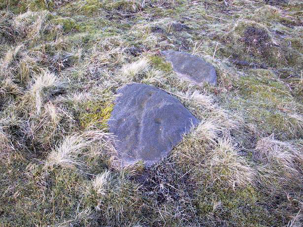
Middleton Moor CR-006

Another off-the-beaten track site!  Follow the directions to reach the Middleton Moor 001 carving, then walk due east for about 500 yards until you reach the distinct footpath that’s the Roman Road.  Once here, zigzag along its edge on the western side, up and down hereabouts.  Keep looking around till you see the stone shown in Richard’s photo here!

Archaeology & History

First found in April 2005, this medium-sized flattish stone is just 10 yards west of the prehistoric trackway which cuts across the moors  — later used as a Roman road — on Middle Gill Bents.  A somewhat simplistic design, it was found by Richard Stroud when we were exploring some of the many other carvings up here, and looking for previously unrecorded ones hiding in the heather.  Carved onto this stone are eight, perhaps nine cup-markings, with grooved lines connecting at least two of them.  That’s it!

© Paul Bennett, The Northern Antiquarian


Middleton Moor Carving (441), North Yorkshire

Cup-and-Ring Stone:  OS Grid Reference – SE 10887 51381


Getting Here

From the back of Moor End Farm on the south-side of Langbar village, follow the Long Ridge footpath up onto the moor. Walk along the path until its starts dipping down again, onto the moor proper and where another footpath crosses and goes down into the small valley of the Dryas Dike stream, follow it – though only for about 75 yards, heading diagonally into the heather slowly towards the stream.  You’re getting close!

Archaeology & History

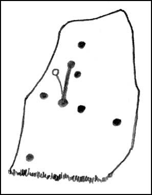
Crude drawing of CR441

Yet another small carving found amidst a decent cluster of cup-and-rings and other archaeological remains near the top of Dryas Dike, this stone was first described in the Boughey & Vickerman (2003) survey.  It’s located about 10 yards below Middleton Moor CR-440, above the stream of Dryas Dike.  It’s a simple design, comprising of a central groove with a cup at either end and several other cups either side of this central line.  (cheers to Richard Stroud for use of his photo).

References:

  1. Boughey, Keith & Vickerman, E.A., Prehistoric Rock Art of the West Riding, WYAS 2003.

© Paul Bennett, The Northern Antiquarian

Crowbar Stone, Weetwood Moor, Wooler, Northumbria

Cup-and-Ring Stone:  OS Grid Reference – NU 021 278

Also known as:

  1. North Plantation 3
  2. Fowberry Moor Stone 3

Archaeology & History

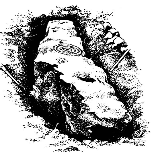
Davison’s sketch

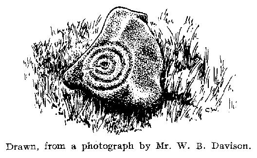
This is an excellent-looking carving which, it would seem, remains buried in the Earth nice n’ sleepy!  Located “in the inner rampart on the south side of an unrecorded camp in North Plantation, Fowberry Moor, Chatton,” the carving was unexpectedly found during some basic excavation work on the camp itself.  Described and illustrated by W.B. Davison (1934), this was one of two cup-and-ring stones hereby.  He reckoned it wasn’t in its original position and seems – from the illustration here – to have been etched onto a fallen monolith.  Davison’s detailed description told:

“The…stone was completely excavated and was found to be built into the inner rampart across its track.  This stone measures 7’6″ north to south, is 1’2″ wide at its north end, 1’11” at its widest part, and 1’3″ at its foot.  The average depth is 2’6″.  The base is rough-surfaced and is prow-shaped at the northern end.

“Incised markings occur on the top only, and are as follows, reading from north to south.  1 cup surrounded by a ring and a half-ring lying east to west by south.  1 small cup.  1 cup.  1 cup surrounded by four rings, the largest of which has a diameter of 13½”.  On the top of the outer ring occurs an abutting semicircle enclosing a cup.  On the accompanying (image) will be observed what appears to be another cup on the innermost ring.  1 cup.  1 cup surrounded by a ring and a half-ring lying north to south by west.  This marking rests on a two-inch deep slot possibly made for quarrying purposes.  No other markings occur between this slot and the foot of the stone.  Tool marks are very distinct on some of the above markings.”

Rock art researchers Jan Brouwer (2007) and Stan Beckensall have searched unsuccessfully for the stone in recent years.

References:

  1. Beckensall, Stan, Northumberland’s Prehistoric Rock Carvings, Pendulum: Rothbury 1983.
  2. Beckensall, Stan, Prehistoric Rock Art in Northumberland, Tempus: Stroud 2001.
  3. Brouwer, Jan, ‘In Search of the Crowbar Stone,’ BRAC 2007.
  4. Davison, W.B., ‘Cup-and-Ring Marked Rocks at Fowberry Park,’ in Proceedings of the Society of Antiquaries of Newcastle-upon-Tyne (4th Series), 4:7, October 1934.

© Paul Bennett, The Northern Antiquarian
Fowberry Moor Farm, Wooler, Northumberland

Cup-and-Ring Stone:  OS Grid Reference – NU 029 261

Also known as:

  1. Deershed Plantation Stone

Archaeology & History

This is a small but impressive stone, presently housed in the Musuem of Antiquities in Newcastle.  It was first mentioned by Mr H.L. Honeyman (1934) as being donated to Newcastle’s Society of Antiquaries by a Mr J.M. Strother of Fowberry Moor Farm in 1934.  He described the carving as,

“a sculptured ring-marked stone, 1ft 2in by 1ft 2in, bearing a cup with three rings and duct. Found in Island Plantation (camp), Fowberry Moor, Chatton, 22.7.34, by Mr Wake.”

Stan Beckensall (1983:127) described it in passing his early work on Northumberland rock art, then again in his updated edition.

References:

  1. Beckensall, Stan, Northumberland’s Prehistoric Rock Carvings, Pendulum: Rothbury 1983.
  2. Beckensall, Stan, Prehistoric Rock Art in Northumberland, Tempus: Stroud 2001.
  3. Honeyman, Herbert L., ‘The Society’s Meetings: July,’ in Proceedings of the Society of Antiquaries of Newcastle-upon-Tyne (4th Series), 4:7, October 1934.

© Paul Bennett, The Northern Antiquarian