From Shipley Glen, walk up to the Dobrudden caravan park on the western side pof Baildon Hill and then in the long grasses immediately north of here, on the Low Plain, this old carving could once be found. I’m told it’s been moved in recent years (but have a mooch round anyway – there’s a number of other old cup-and-rings in the locale).
Archaeology & History
This small carving is not in its original position, having been moved to where it now sits a short distance northeast of the Dobrudden caravan park. It was first described briefly in Mr Baildon’s magnum opus here, seemingly omitted from the Hedges (1986) and reclassified as ‘stone 169’ by Boughey & Vickerman (2003). I’m not 100% certain that the illustration here by Joseph Rycroft and carving no.169 are one and the same – but they seem incredibly alike. If anyone knows for sure, one way or the other, please lemme know and I’ll amend as necessary!
References:
Baildon, W. Paley, Baildon and the Baildons – part 7, Adelphi Press: London 1913.
Boughey, Keith & Vickerman, E.A., Prehistoric Rock Art of the West Riding, WYAS 2003.
Hedges, John (ed.), The Carved Rocks on Rombalds Moor, WYMCC: Wakefield 1986.
C.F. Forshaw (1908) told us that “this Castlestead…lies on the high ground between Cullingworth and Denholme, about 300 yards east of the point where te Cullingworth Road meets the Halifax-Keighley Road in Manywells Height, and over looks Buck Park Woods and the beck flowing down a deep ravine to enter the head of Hewenden Reservoir. A little to the north lies Moat Hill Farm…and the ancient burial place therewith associated.” Very little remains of the site can be seen.
Archaeology & History
C.F. Forshaw’s 1908 plan of this Castle Stead site
Just over a mile southeast of the site of (virtually) the same name — the Castlestead Ring — this here Castle Stead site had me thinking that both sites were one and the same (poor research on my behalf I’m afraid). At the moment, the archaeological period of when this site was constructed remains unknown. Thought by Forshaw (1908) to be “almost certainly a hitherto unknown Roman entrenchment,” the very slight remains left here could be Iron Age or Romano-British. In his lengthy article on the remains that could be seen here more than 100 years ago, Mr Forshaw told us:
“Several fields hereabouts bear the name Castlestead and one of these contains the entrenchment, which almost coincides within its area… The reason for the selection of this site is clear, for on no side is it commanded by higher ground: whilst one face has a natural fortification of a rock scar impassable at most points and easily accessible at none. Here very little art would make the position impregnable in primitive warfare, and it is noticeable that the most suitable part of the verge has been selected, and almost the whole of the scar has been included. It is, however, only right to state that stone has been quarried here within living memory and this may have altered the ground considerably, and may account for several features mentioned hereafter.
“The accompanying plan (above) will make the outline of the fortification clear, and from it one can readily recognise the usual Roman form. The moat and bank, the quadrangular shape with rounded corners and the entrances on three sides (and possibly on the fourth also) are characteristic. The unusual point is the selection of a natural fortification for one (the south) side.
“The question at once arises: was this a permanent stone fort? Clearly not, for the bank has been cut across at four places (A, D, H & L) and not only was no stone found — beyond such odds and ends as may be seen in any field — but the deeper, undisturbed layers of silt showed no signs of a trench in which foundations might have stood. It is noticeable that there are more stones on the crown of the bank than elsewhere. This I take to be the remains of what was thrown up in the bank. The field has been cultivated many years, so that the bank has been much reduced in height and the moat filled up.
“The original height of the bank is difficult to guess, but the moat was about three feet deeper than at present at the point H, and from the amount of soil removed we may imagine the bank about five feet higher than it is now, and solid at that; this makes a total outside slope of about 10 feet, a very formidable obstacle to surmount in the face of opposition, especially is strengthened by a stockade, such as was possibly present.The remains of the bank are capped with a layer of some six inches of bluish, silty clay. This was evidently placed there deliberately, and is in accordance with Roman work as seen elsewhere (e.g., at Castleshaw, near Oldham). There is also some slight evidence that, as at Castleshaw, the moat was once faced with irregular pieces of flat stone. The moat was some 18 feet across at the top, six feet at the bottom and five feet deep. The east and west sides were probably less strongly entrenched. Certainly the moat was much less, for rock lies only just below the sod, halfway along the western side. When the southern face is examined there are more signs of stonework, however, for where the rock is deficient the gap is filled with the remains of a dry wall which has some peculiar characteristics. In places the lower part of this wall is formed of roughly-shaped oblong blocks of large size (one has a face of 57 x 17 inches), arranged in definite tiers. This is not like an ordinary field fence, and differs even more from the ancient wall marked (probably erroneously) as Denholme Park Wall on the Ordnance map, which it continues: so it is conceivable that it may be Roman work. There is now little or no sign of a bank along the rocks bounding the southern side of the camp, but it is probable that something once existed to give cover to the defenders, and we may well imagine a low dry wall continuous with the fragments just described: and it is rather noticeable that there are more squared stones in the walls of this field than in others in the neighbourhood.
“There are no traces of buildings within the lines so far as the present investigations go, nor signs of prolonged occupation at the site. I have dug at the points indicated (on the map above) and came upon rock or disturbed silt in each case. The circular shallow hollow in the centre seems natural. It is to be remarked that the average depth of surface soil in this field is unusual, more than one foot in fact.”
Mr Forshaw then goes on to ask a series of questions, followed by his own particular answers and theory relating to the nature of these earthworks. Hopefully you won’t mind if I cite his ideas in full, despite him thinking that the remains here are of Roman origin (remains of which I don’t really wanna include on TNA). He continued:
“Was this camp on the course of a Roman road? One can only say that no definite road exists at the entrances now, but there seems some ground for thinking that a surface was prepared…at the western entrance for two reasons:
1. Just to the north the rock is covered with made soil only; but in the entrance itself irregular stones are packed in a level, solid manner, giving a strong impression of artificiality. At the southern verge of the entrance this layer ends abruptly in a line at right angles to the bank, and here it is based not on rock, but on natural silt.
2. A slight hollow runs straight westward from it for some twenty yards through the next field. This may represent a destroyed road.”
Mr Forshaw then makes a few attempts to justify this idea, including notices of footpaths and linear features near the site, aswell as citing earlier historical sources that describe Roman roads — but the ones cited are some considerable distance from this site. In summing up, he notes how no Roman finds were made here — nor indeed any finds from earlier periods — but he opted for the site being a temporary Roman outpost. The more recent opinions of this place are that it was of late Iron Age or Romano-British origin.
References:
Cudworth, William, Round about Bradford, Thomas Brear: Bradford 1876.
Forshaw, C.F., ‘Castlestead, near Cullingworth,’ in Yorkshire Notes and Queries – volume 4, H.C. Derwent: Bradford 1908.
Hindley, Reg, Oxenhope: The Making of a Pennine Community, Amadeus: Cleckheaton 2004.
James, John, The History and Topography of Bradford, Longmans: London 1876.
Keighley, J.J., ‘The Prehistoric Period,’ in Faull & Moorhouse’s, West Yorkshire: An Archaeological Survey to AD 1500 – volume 1, WYMCC: Wakefield 1981.
Varley, Raymond, “The Excavation of Castle Stead at Manywells Height, near Cullingworth, West Yorkshire,” in Transactions of the Hunter Archaeological Society, volume 19, 1997.
From Earby, go eastwards up the steep moorland Coolham Lane. A coupla hundred yards up past the little reservoirs on your right there’s a tall, large wooden stile to climb over, up the old heaps of quarried stone and onto the flat moorland plain of Bleara Moor. You’re here! If the heather’s grown back however, you’ve no chance of seeing ’em!
Archaeology & History
One of at least a dozen small cairns on NW of Bleara Moor
When we came up here the other day (ostensibly to check out the great Bleara Lowe tombs on top of the moor), a grey wet day scattered its more darkened light across the moor, which thankfully had been burnt back a few months previous. If this hadn’t happened, we’d have never seen what we found: a scattering of at least a dozen small single cairns, typical of those found on the upper and lower slopes of Green Crag Slack on Ilkley Moor. They’re on the lower northwest-facing plain of Bleara Moor and all are roughly the same size: about 3 yards by 3 yards across and only a foot or two in height, much overgrown in peat and vegetation. Although we found a good number of these small cairns where the heather had been burnt away, there also seemed to be others in the long heather itself, but this was, of course, hard to say with any certainty. A few more exploratory ventures in and around the moor would be good after the next heather-burning sessions!
From Heysham village centre by the little roundabout, go down the gorgeous olde-worlde Main Street for about 150 yards, keeping your eyes peeled for the little track up to the tree-lined church of St. Peter. Just before going up the path to the church, set back at the roadside, you’ll see an old pump in an arch in the walling. That’s St. Patrick’s Well!
St.Patrick’s Well, Heysham
Archaeology & History
Not to be confused with another St. Patrick’s Well a few miles north of here, little has been said of this old holy well in literary tomes (even Henry Taylor’s (1906) magnum opus missed it!) Sadly the waters here have long since been diverted (which violates religious tradition, quite frankly), and all we see today is an old iron water-pump set inside a stone arch, beneath which – I presume – the waters once ran. An old plaque on the site of this ancient well tells:
“This is one of two holy wells in Heysham village (the other, Sainty Well, is on private property and covered over), whose dedications are long since lost. Latterly the water from this well was used for utilitarian gardening purposes within the confines of the old rectory.
“Previously the well had fallen into disuse, suffered from surface contamination and became rubble-filled when the bank above gave way in the mid-1800s. In the early 1900s, the well-head was again rebuilt and the well itself was cleaned and made safe by capping with concrete. Recently (May 2002) the well-head has been refurbished and water artificially introduced, thus turning a derelict area into a feature of the village.”
It would be good if local people could complain to the regional water authority and make them redirect the waters beneath the well, back to the surface, to allow devotees — both Christian and otherwise — to partake of the holy blood sanctified by St. Patrick many centuries ago. And without fluoride or other unholy chemical compounds that desecrate our waters. Just the sacred waters of God’s Earth please!
Folklore
This is one of the many places in the British Isles where St. Patrick was said to have landed after he’d converted all the Irish into the christian cult! One of the traditions was that St. Patrick said the well would never run dry — which was shown to be untrue when the waters were filled in with rubble in the 19th century. The same saint also used the waters from the well to baptise and convert the peasants of his time.
References:
Quick, R.C., Morecambe and Heysham, Past and Present, Morecambe Times 1962.
From East Morton village, take the moorland road, east, and up the steep hill. Where the road levels out there’s a right turn, plus (more importantly!) a trackway on your left which leads onto the moor. Go up this track for a few hundred yards until you’re on the moor proper (by this I mean the track’s levelled out and you’re looking 360° all round you with all the moor in front of you). Just before the track starts a slight downhill slope, go into the heather on your right, for about 80 yards. You’re damn close!
Archaeology & History
I first came here many years back in my mid- to late-teens with an old school-friend Jon Tilleard, wandering about adventurously, occasionally stopping here and there when I found some stupid cup-mark or other seemingly innocuous scratch on the rocks, gerrin’ all excited and jumping about like a tit! But when we visited the place again a few days back my response was somewhat different. I was worse! But for good reason…
Primary features of CR-107Close-up of main features
The potential variations visible in this carving are peculiar, to say the least. Ones first impression shows a carving similar in many ways to that shown in Hedges (1986) fine survey; but upon closer inspection a number of initial visual responses begin to look murky. A seeming cup-with-double-ring aint what it seems! To me at least (sad fella that I am!), it’s far more intriguing and far less certain, with a number of oddities still left.
The central feature of the carving is the lovely near-cup-and-double-ring! As we can see in the photo here, there are some insecurities in the top-right of the outer ring. To the upper right of this is another cup-with-partial-ring that was not included in the Hedges (1986) survey, nor Boughey & Vickerman’s (2003) updated work. There are some obvious pecked carved lines — whose specific definition yet remains unclear — in and around this area of the petroglyph; but in the “official” illustration these elements or ingredients were somehow missed.
Eclipse Stone, looking west
When we visited the stone the other day, the naturally eroded lines on the rock seemed pretty obvious; but the more we looked, the less secure we were about some of them. Thankfully the light kept changing about, allowing us to get different perspectives — and with the low sunlight of evening casting itself across the rock, some additional features seemed obvious. In particular, what seemed like two natural “scratches” on the stone turned out to have been pecked and carved and the straight lines ran into the double cup-and-ring on the left-side. One of these — the lower and shorter of the two — seems to run into the central cup, but this aint certain. The longer top line has an even more circuitous venture: entering the outer ring, it passes onto the top-inner ring and then bends along its edge, before exiting again on the right-hand side, through the outer ring and heading out towards the large natural eroded cutting a few feet away (see my crappy drawing to get an idea). Other faint aspects on this stone may have the hand of man behind them…
My shit sketch!Hedges 1986 sketch
There are certainly a few other cups on the stone: one with a near semi-circle on its lower and right-hand side. The long nature-worn cut, right-of-middle, may have had the hand of man cutting into the cup at the bottom; and another couple of “is it? — isn’t it?” enhanced natural cups seem possible on the left side of the rock. There is also what looks like a distinct single cup-marking on the west-facing vertical face of the stone (you walk towards it from the track). It looks pretty decent, but I’ll let them there “professionals” assess the validity or otherwise of that one! But the other unmistakable and very curious ingredient is the deep, worn arc beneath the primary double-ring feature. This is, as the photo shows, separated by a long natural crack running halfway down and along the stone, above which possibly the double-ring feature touches. This large ‘arc’ feature gives the distinct impression of being a big smile! However…
Turn the image of the central feature upside down and you get a very different effect indeed. A rainbow above the surface of the Earth, with (perhaps) a pool in which the sun has reflected? Or an underworld venture? Looking at it from a few angles gives the impression of a comet moving across the sky, aswell as an eclipse with the diamond-ring effect. But as with cup-and-ring in general, there are plenty of other potentials! Which also begs the question: was it to be looked from the top or bottom (or left or right for that matter)?
I could waffle about this particular carving for much longer, showing that it had quite an effect on me. Check it out and sit with it for a while… It’s superb!
References:
Boughey, Keith & Vickerman, E.A., Prehistoric Rock Art of the West Riding, WYAS 2003.
Hedges, John (ed.), The Carved Rocks on Rombalds Moor, WYMCC: Wakefield 1986.
The present day Market Cross that stands in Glastonbury’s High Street, ornate though it may look, replaced a much earlier and more memorable monument. The one we see today, said Charles Pooley (1877),
“at the junction of the four streets, was erected in 1846, after the design of B. Ferrey, Esq., at the instance and the cost of a private individual. It is a Gothic pinnacled structure of a simple type, with no pretensions to elaborate architectural display.”
The ancient Market CrossThe new Market Cross
A very poor substitute for the cross that stood in its place in earlier centuries, from all accounts. Before the modern spire was erected, an earlier, larger and more ornate structure — that seems to have been first described in John Leland’s classic Itinerary (1744 ) in the middle of the 18th century, simply as “the Market Crosse in the West Ende” — was the meeting point for the tradesmen and villagers of Glastonbury. Although Rahtz & Watts (2003) followed Leland in giving only passing mention to this once ornate structure, thankfully a number of earlier antiquarians gave the old cross a bit more literary attention. Mr Pooley (1877) again informs us:
“Warner, who was in Glastonbury in 1799, says, “In my way to the Abbey, I passed the Market Cross, and old polygonal structure, its apex crowned with a little naked figure, bearing strong marks, in its position and employment of that grossness of taste, in which the sculptors of the 15th century so frequently indulged.”
Other writers weren’t as puritanical in their descriptions. In John Britton’s (1807) tour of the architectural curiosities of the region he remarked:
“Though a large and extremely curious structure…it is scarcely noticed in the topographical annals of the county; its history is, therefore, perhaps entirely lost. Since the drawing was taken in 1802, the Cross had been suffered gradually to fall into ruins, part of the centre column then only standing.” He continued: “There is something peculiarly unique in the shape and ornament of this building. A large column in the centre, running through the roof, and terminating with a naked figure, clustered columns at each angle with odd capitals, bases, etc., and gables with pinnacles of unusual shape, all unite to constitute this one of the eccentricities of ancient building. From the time of the Norman Conquest to the Dissolution of the Engilsh Monasteries, the varied and progressive styles of architecture are satisfactorily defined, and a very general uniformity prevails in all the buildings of particular eras; but the specimen before us differs from anything that we have yet met… In the year 1802 there was a mutilated inscription on it, with the year 1604, but we cannot say that this date refers to the time of its building. There were also some armorial bearings carved on different parts of it. Among these were the arms (a cross between two cups) of Richard Beere, the last Abbot but one of Glastonbury. The presence of the canting device of Richard Beere would probably determine the date of its erection.”
Mr Pooley’s (1877) own description of the old cross told that,
“It was built of hewn stone on an octagonal plan, having clustered pillars ranged round a central column supporting the roof. Three steps, the lower one benched, surrounded the base of the shaft, for the convenience of the market people. The gables were terminated by moulded pinnacles, and the central shaft, which rose above the roof, was surmounted by a statue. Adjoining the cross was an ancient conduit, having a vaulted roof, and supplied with water from a reservoir at the uper part of town. These structures being in want of repair…it was determined to pull them down, which was done accordingly in the year 1808.”
So the next time anyone visits Glastonbury’s tall spired cross in the middle of the town, remember its old and much more ornate predecessor. Perhaps some of you arty-types down there could do a replica of the old thing with its naked figurines and resurrect it from its forgotten past…
References:
Britton, John, The Architectural Antiquities of Great Britain, Longman, Hurse: London 1807.
Leland, John, The Itinerary, James Fletcher: Oxford 1744.
Michell, John, New Light on the Ancient Mystery of Glastonbury, Gothic Image: Glastonbury 1990.
Pooley, Charles, The Old Stone Crosses of Somerset, Longmans, Green & Co.: London 1877.
Rahtz, Philip & Watts, Lorna, Glastonbury: Myth and Archaeology, Tempus: Stroud 2003.
Get up to the Twin Towers right at the top of Ilkley Moor (Whetstone Gate), then walk east along the footpath, past the towers for about another 100 yards, looking out on the other side of the wall until it meets with some other walling running downhill onto Morton Moor. Follow this walling into the heather for a few hundred yards. Where it starts dropping down the slope towards the small valley, stop! From here, follow the ridge of moorland along to your left (east) and keep going till you’re looking down into the little valley proper. Along the top of this ridge if you keep your eyes peeled, you’ll find the stone cross base sitting alone, quietly…
Archaeology & History
This old relic, way off any path in the middle of the moor, has little said of it. Whilst its base is still visible — standing on a geological prominence and fault line — and appears to taken the position of an older standing stone, christianised centuries ago, the site is but a shadow of its former self. When standing upright may centuries back, the “cross” was visible from many directions. We discovered this for ourselves about 20 years back, when Graeme Chappell and I sought for and located this all-but-forgotten monument. When we found the stone base, what seemed like the old stone cross lay by its side, so we repositioned it back into position on July 15, 1991. However, in the intervening years some vandal has been up there and knocked it out of position, seemingly pushing it downhill somewhere. When we visited the remains of the cross-base yesterday (i.e., Dave, Michala Potts and I) this could no longer be located. A few feet in front of the base however, was another piece of worked masonry which, it would seem, may have once been part of the same monument.
Cross-base, looking northClose-up of cross-base
Years ago, after Graeme and I had resurrected the “cross” onto its base, I went to visit the Bradup stone circle a few weeks later and found, to my surprise, the upright stone in position right on the skyline a mile to the northeast, standing out like a sore thumb! This obviously explained its curious position, seemingly in the middle of nowhere upon a little hill. This old cross, it would seem, was stuck here to replace the siting of what seems like a chunky 3½-foot long standing stone, lying prostrate in the heather about 10 yards west of the cross base.
Stuart Feather (1960) seems to be the only fella I can find who described this lost relic, thinking it may have had some relationship with a lost road that passed in the valley below here, as evidenced by the old milestone which Gyrus and I resurrected more than 10 years back. Thankfully (amazingly!) it still stands in situ!
If you aint really into old stone crosses, I’d still recommended having a wander over to this spot, if only for the excellent views and quietude; and…if you’re the wandering type, there are some other, previously undiscovered monuments not too far away, awaiting description…
References:
Bennett, Paul, The Old Stones of Elmet, Capall Bann: Chieveley 2001.
Feather, Stewart, “A Cross Base on Rombald’s Moor,” in Bradford Antiquary, May 1960.
Feather, Stewart, “Crosses near Keighley,” in Cartwright Hall Archaeology Group Bulletin 5:6, 1960.
From East Morton village, take the moorland road, east, and up the steep hill. Where the road levels out there’s a right turn, plus (more importantly!) a trackway on your left which leads onto the moor. Go up this track and keep walking till you hit a moorland ‘footpath’ signpost. Just before this walk due west (your left) into the heather for about 10 yards. Look around! (if the heather’s long and overgrown, you might have trouble finding it) If you find carved stone 109, you’re less than 10 yards off this one!
Archaeology & History
First reported by Stuart Feather and described in a short note of the Yorkshire Archaeological Register* of 1977. This was one of two small carved stones next to each other amidst the “denuded remains of a cairn 3m in diameter and 0.35m high.” The stone we can still see here is a small one, seemingly near the very centre of the cairn, with its carved face looking northwards. The carving is a simple double-ring surrounding a central cup: an almost archetypal cup-and-ring stone.
Crap photo of the double-ring
The other ancient carved stone that was once seen next to this (catalogued as carving 111) has in recent years been stolen by an archaeological thief no less! Any information that anyone might have telling us who’s stolen this heritage piece, or where it might presently reside, can be emailed to me in confidence. Or…the thief who’s taken it can return the carving to the site and put it back where it belongs before we find out where you live. Simple as!
(Soz about the poor photo of this carving. For decent ones of this stone you need to get here when the sun’s in a better position. I’ll hopefully get some better images next time we’re up there when the light’s better.)
References:
Boughey, Keith & Vickerman, E.A., Prehistoric Rock Art of the West Riding, WYAS 2003.
Hedges, John (ed.), The Carved Rocks on Rombalds Moor, WYMCC: Wakefield 1986.
Moorhouse, S. (ed.), “Yorkshire Archaeological Register: 1977,” in Yorkshire Archaeology Journal, volume 50, 1978.
* Does anyone have any idea who you report such new discoveries to so that they can be reported in Yorkshire Archaeology Society’s ‘Register’? I’ve asked ‘em several times about a number of previously unrecorded sites that we’ve located, so that they can make a record of them, but I never get a reply.
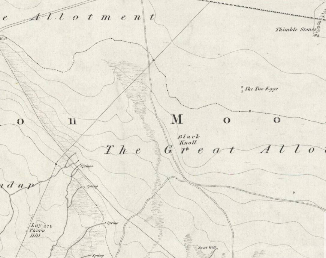
Takes a bitta finding this one. From the Twin Towers at the top of the moors (Whetstone Gate), walk east along the footpath, past the towers for about another 100 yards, looking out on the other side of the wall until you meet with some walling running downhill onto Morton Moor. Follow this walling for a few hundred yards till it drops down a small valley; then follow the valley down, keeping to its left-hand side, swerving a little round Black Knoll above you. Cross the dried-up stream and about 100 yards ahead of you (southeast), heading towards the Sweet Well, zigzag about (once the heather’s grown back here, this’ll take some finding!). Good luck!
Archaeology & History
Cup-markings, looking north
There’s no previous history to this site and archaeological records indicate no prehistoric remains in this region. However, we (that is Dave, Mikki and me) found this and a number of other sites yesterday in a bimbling wander, to and fro, through boggy-heaths and deep heather. It’s a previously unrecorded cup-marked stone, with what seems like an attached burial cairn right by its side (yet again!). The cairn is 3 yards by 2 yards across. Two very distinct cup-marks can clearly be seen near the top of the small stone, with a possible third just below. A curious though natural yoni-like erosion can be seen on the lower side of the stone which may have some significance to people into that sorta thing! Whether it had owt to do with the cup-markings is another thing altogether!
From East Morton village, take the moorland road, east, and up the steep hill. Where the road levels out there’s a right turn, plus (more importantly!) a trackway on your left which leads onto the moor. Go up this track and keep walking till you hit a moorland ‘footpath’ signpost. Just before this walk due west (your left) into the heather for about 10 yards. Look around! (if the heather’s long and overgrown, you might have trouble finding it)
Archaeology & History
Thought to be one of several carvings that were first reported by Stuart Feather and described in the Yorkshire Archaeological Register* of 1977: near the “denuded remains of a cairn” (there are in fact two here) is “a further cup-marked rock adjacent.” This is thought to be the one registered in John Hedges’ (1986) survey as ‘stone 91’. It’s a cute little thing, about 10 yards south of carving 110 (itself sited near the centre of a much-denuded burial cairn).
Carving 109, when wet!and when dry!
Similar in design to some of the Baildon Moor cup-marked stones (see carving no.126), the primary design here is a simple one: five cup-markings run along the edge of the small stone, with a small carved “line” running between two of the cups, as if denoting separation; whilst on the lower middle part of the stone is another, single cup, a little more worn than the others. It seems likely that this carving, like its double-ringed companion a few yards away (and others on this part of the moors) was in some way associated with the nearby prehistoric cairns.
References:
Boughey, Keith & Vickerman, E.A., Prehistoric Rock Art of the West Riding, WYAS 2003.
Hedges, John (ed.), The Carved Rocks on Rombalds Moor, WYMCC: Wakefield 1986.
Moorhouse, S. (ed.), “Yorkshire Archaeological Register: 1977,” in Yorkshire Archaeology Journal, volume 50, 1978.
* Does anyone have any idea who you report such new discoveries to so that they can be reported in Yorkshire Archaeology Society’s ‘Register’? I’ve asked ’em several times about a number of previously unrecorded sites that we’ve located, so that they can make a record of them, but I never get a reply.