About a metre tall and found standing near the bottom of one of the fields diagonally across from the old farmhouse of Laverock Hall, here’s another old stone which may not have a prehistoric provenance. It is seemingly unknown by all but local people and would seem to be an old rubbing post for cattle — albeit a small one! There seems to be no written accounts of this stone; though until all of the local field-name maps have been checked, we can’t discount the possibility that this is the “standing stone” described in early place-name records that was mentioned by A.H. Smith in 1963.
References:
Bennett, Paul, The Old Stones of Elmet, Capall Bann: Milverton 2001.
Smith, A.H., The Place-Names of the West Riding of Yorkshire – volume 6, Cambridge University Press 1963.
From Harden, go up Moor Edge High Side (terraced row) till you reach the top. Follow the path thru’ the woods on the left side of the stream till you bend back on yourself and go uphill till you reach the moor edge. Keep walking for about 500 yards and keep an eye out to your immediate left. The other route is from the Guide Inn pub: cross the road and go up the dirt-track on the moor-edge till you reach a crossing of the tracks where a footpath takes you straight onto the moor (south). Walk on here, heading to the highest point where the path eventually drops down the slope, SE. As you drop down, watch out for the birch tree, cos the circle’s to be found shortly after that, on your right, hidden in the heather!
Archaeology & History
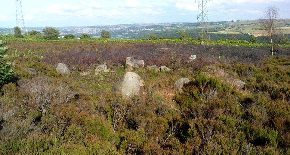
This aint a bad little site hidden away on the small remains of Harden Moor, but is more of a ‘ring cairn’ than an authentic stone circle (a designation given it by previous archaeologists). An early description of it was by Bradford historian Butler Wood (1905), who also mentioned there being the remains of around 20 small burials nearby. When the great Sidney Jackson (1956; 1959) and his team of devoted Bradford amateurs got round to excavating here, he found “four or five Bronze Age urns” associated with the circle. His measurements of the site found it to be 24 feet across, and although the stones are buried into the peat with none of them reaching higher than 3 feet tall, it’s a quietly impressive little monument this one. About 20 upright stones make up the main part of the ring.
I’ve visited the place often over the last year or so since a section of the heather has been burnt away on the southern edges of the circle. This has made visible a very distinct surrounding raised embankment of packing stones about a yard wide and nearly two-feet high, particularly on the southern and eastern sides of the circle, giving the site a notable similarity in appearance and structure to the Roms Law circle (or Grubstones Ring) on Ilkley Moor a few miles to the north.
There is also the possibility that this ring of stones was the site described by local historian William Keighley (1858) in his brief outline of the antiquities of the region, where he wrote:
“On Harden Moor, about two miles south of Keighley, we meet with an interesting plot of ground where was to be seen in the early days of many aged persons yet living, a cairn or ‘skirt of stones,’* which appears to have given name to the place, now designated Cat or Scat-stones. This was no doubt the grave of some noted but long-forgotten warrior.
* The Cairn was called Skirtstones by the country people in allusion to the custom of carrying a stone in the skirt to add to the Cairn.”
However, a site called the ‘Cat stones’ is to be found on the nearby hill about 500 yards southeast – and this mention of a cairn could be the same one which a Mr Peter Craik (1907) of Keighley mentioned in his brief survey of the said Catstones Ring at the turn of the 20th century. We just can’t be sure at the moment. There are still a number of lost sites, inaccuracies and questions relating to the prehistoric archaeology of Harden Moor (as the case of the megalithic Harden Moor Stone Row illustrates).
Section of the inner ring
The general lack of an accurate archaeological survey of this region is best exemplified by the archaeologist J.J. Keighley’s (1981) remark relating specifically to the Harden Moor Circle, when he erroneously told that, “there are now no remains of the stone circle on this site” — oh wot an indicator that he spent too much time with paperwork! For, as we can see, albeit hidden somewhat by an excessive growth of heather, the ring is in quite good condition.
It would be good to have a more up-to-date set of excavations and investigations here. In the event that much of the heather covering this small moorland is burnt back, more accurate evaluations could be forthcoming. But until then…..
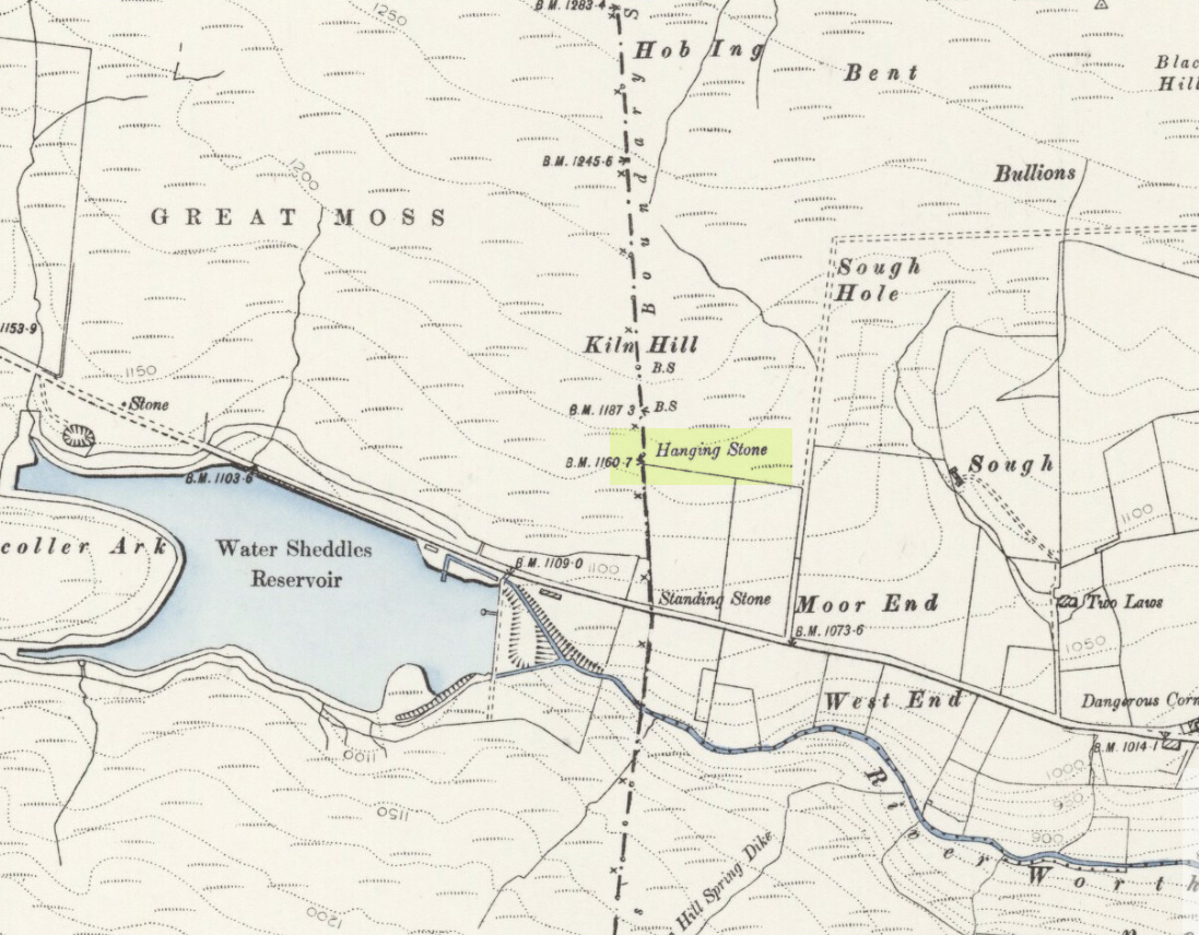
Pretty easy to find. Go along the Oakworth-Wycoller road, between Keighley and Colne, high up on the moors. When you get to the Water Sheddles Reservoir right by the roadside (y’ can’t miss it), stop! On the other side of the road walk onto the moor, heading for the walling a coupla hundred yards to your east (right). Where the corner edge of the walling ends, your standing stone is right in front of you! If for some reason you can’t see it, wander about – though beware the very boggy ground all round here.
Archaeology & History
This seven-foot tall monolith, leaning to one side thanks to the regularly water-logged peat beneath its feet, stands on the Yorkshire-Lancashire. It is locally known as the Hanging Stone and the Standing Stone, but the name ‘Water Sheddles’ is a bittova puzzle. The place-names authority, A.H. Smith (1961) thinks it may derive from the middle-english word, shadel, being a ‘parting of the waters’ – which is pretty good in terms of its position in the landscape and the boggy situation around it. But ‘sheddle’ was also a well-used local dialect word, though it had several meanings and it’s difficult to say whether any of them would apply to this old stone. Invariably relating to pedlars, swindling or dodgy dealings, it was also used to mean a singer, or someone who rang bells, or a schedule, aswell as to shuffle when walking. Perhaps one or more of these meanings tells of events that might have secretly have been done here by local people, but no records say as such — so for the time being I’ll stick with Mr Smith’s interpretation of the word! Up until the year 1618 it was known simply as just a ‘standing stone’, when it seems that the words “Hanging Stone or Water Sheddles Cross” were thereafter carved on its west-face, as the photo below shows.
Cross carved on top of the stoneThe old stone, with its names carved for all to see
Whether or not this stone is prehistoric has been open to conjecture from various quarter over the years. Is it not just an old boundary stone, erected in early medieval times? Or perhaps a primitive christian relic? Certainly the stone was referred to as “le Waterschedles crosse”, as well as “crucem”, in an early record describing the boundaries of the parish of Whalley, dating from around the 15th century. This has led some historians to think that the monolith we see today is simply a primitive cross. However, sticking crosses on moortops or along old boundaries tended to be a policy which the Church adopted as a means to ‘convert’ or christianize the more ancient heathen sites. It seems probable in this case that an old wooden cross represented the ‘crucem‘ which the monks described in the early Whalley parish records.
Site marked on 1892 map
This monolith likely predates any christian relic that might once have stood nearby; although the carving of a ‘cross’ on the head of the stone may have supplemented the loss of the earlier wooden one. But it seems likely that this carved ‘cross’ was done at a later date than the description of the ‘crucem‘ in the parish records — probably a couple of centuries later, when a boundary dispute was opened, in 1614, about a query on the precise whereabouts of the Yorkshire-Lancashire boundary. After several years, as John Thornhill (1989) wrote,
“the matter was resolved on the grounds that the vast Lancastrian parish of Whalley had claimed territorial jurisdiction as far east as the Hanging Stone, thus the county boundary was fixed on the Watersheddles Cross.”
Water Sheddles stone looking SW
Certainly the stone hasn’t changed in the last hundred years, as we can tell from a description of it by Henry Taylor (1906), who said:
“The remains consist of a rough block of stone, leaning at an angle of about forty-five degrees against a projecting rock. The top end has been shaped into the form of an octagon, on the face of which a raised cross is to be seen. The stone is about six feet long and two feet wide, tapering to eleven inches square at the upper end, and appears once to have stood upright. Some local authorities have cut on it the words, ‘Hanging Stone or Waterscheddles Cross.'”
So is it an authentic prehistoric standing stone? Tis hard to say for certain I’m afraid. It seems probable – but perhaps no more probable than the smaller Great Moss Standing Stone found just a couple of hundred yards away in the heather to the west, on the Lancashire side of the boundary. Tis a lovely bitta moorland though, with a host of lost folktales and forgotten archaeologies…
In the vicinity of the denuded ring-cairn and old tumulus of Wortshorne Hill, the Calderdale historian Mr J.A. Heginbottom (1979) described finding this simple cup-marked rock, a hundred yards or so northwest of the old circle. In my ambles here I was unable to locate it. The stone may have been reburied or destroyed. Prehistoric cup-marked carvings are (officially at least) rare things in Lancashire – and usually where you find one, others lurk close by. Do any local folk out there know anything more about this site?
References:
Heginbottom, J.A., The Prehistoric Rock Art of Upper Calderdale and the Surrounding Area, YAS: Leeds 1979.
Take the single-track country lane between Farnhill and Low Bradley until you reach Hamblethorpe farmhouse. Where the birch woodland is on the slope going uphill, the field on the other side of the road, protected by walling, is where the stones are, just south of the farmhouse. There’s nowhere to park any car hereabouts, so it’s best walking here.
Archaeology & History
It seems that nothing has previously been written of this place. Hidden away at the top of the field we find two curious-looking standing stones: one nearly six-feet tall, and its companion about four-feet. They’re near the bottom of the slope from the giant Round Cairn and Long Cairn tombs of Low Bradley Moor, several hundred yards to the east— and were it not for the fact that they have a distinctive Castlerigg-like appearance about them, perhaps I wouldn’t have given them a second chance. Curious earthworks are in the same field, to which written records also appear silent. Tis a lovely little spot…
Stone Circle (destroyed): OS Grid Reference – TG 524 035
Archaeology & History
Several local history records describe there being a circle of ten standing stones in a field called ‘Stone-field’ or ‘Stone-piece’ – now covered by a housing estate at Gorleston-on-Sea, south of Yarmouth. In 1875, C. J. Palmer said that,
“there is a tradition that the Druids had a temple at Gorleston, some remains of which existed down to a comparatively recent period. It is supposed to have stood on a field next to the road to Lowestoft, upon what is called Great Stone Close; and it has been asserted that some huge stones remained standing until 1768, when they were destroyed by digging round their base and dragging them down by ropes. There are also two fields called Further Stone Close and Middle Stone Close, so that it is possible the Druidical circle, if it ever existed, may have had a wide extent”.
A painting of the site was reported to have been viewed by members of the Norfolk & Norwich Archaeological Society in 1888, but I’ve been unable to find out where this has gone. Anyone out there got a copy? Or know where it hangs? An image of this lost stone circle would be hugely welcome!
References:
Burgess, Michael W., The Standing Stones of Norfolk and Suffolk, ESNA 1: Lowestoft 1978.
Palmer, C.J., The Perlustration of Great Yarmouth – volume 3, George Nall: Gt Yarmouth 1875.
The best way to get here it is to head from the Cow and Calf Hotel up the hillside to where the great rock is sticking out (the Pancake Stone). From here, head straight onto the moor toward the Idol Stone — close to the Idol Rock which you can see 400 yards south in front of you. From here, follow the footpath up the hill before you and keep on the path towards Lanshaw Lass. About 100 yards on, turn straight west into the heather and keep your eye towards the south. About 250 yards on, about 100 yards away from the Green Crag Top cup-marked boulder, you’ll see it!
Archaeology & History
One of very few solitary standing stones on Ilkley Moor, and one which I relocated after The Old Stones of Elmet (2001) had gone to press — which was a great pity. Nearly four feet tall, this is a good chunky monolith which stands close to being on line with the summer solstice alignment from the nearby Twelve Apostles stone circle. (I was gonna call it the Summer Stone, but thought better of it!)
There’s another recumbent stone, more than five feet tall when erected, 200 yards northwest of here. (This is also very close to being in line with with our chunky monolith, plus the Twelve Apostles. Anyone out there with a GPS who can check if this possible alignment is the last remnant of a summer solstice stone row? It probably isn’t, but it’d be good to find out.) On the same moorland level, heading back down, when the heather’s burnt back you’ll find a number of prehistoric tombs along the edge of the ridge. These don’t appear to be in the archaeological registers.
Follow the directions to reach the Great Skirtful of Stones giant cairn (very worryingly being encroached upon, illegally [it’s a protected monument], by employees of Bradford Council digging tracks into its edges). Walk less than 100 yards to the east, down the slight moorland slope (Leeds & Otley Chevin are in the distance). You’re here!
Archaeology & History
This is a very intriguing site. Intriguing because we don’t actually know what it is! It’s best seen at the end of winter, shortly after the heather-burning’s been done; but if there’s been no burning here, after a year or two it’s almost impossible to find!
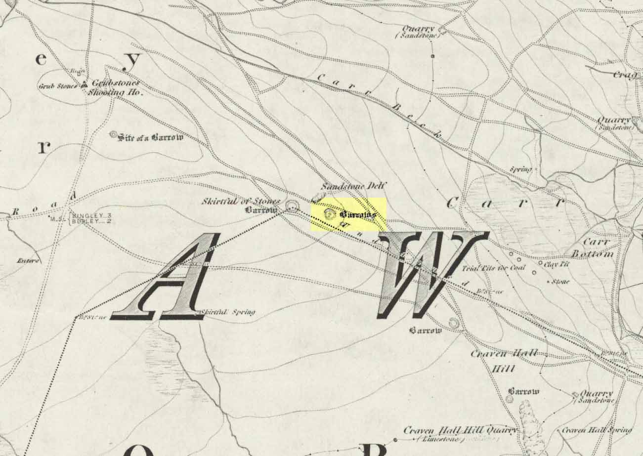
Great Skirtful Ring on 1851 mapColls’ 1846 plan
Despite it being only a short distance east of the Great Skirtful giant cairn, very little has been written about it (a surprise in itself!) – but this is down the failings of archaeological professionals in the area, who still neglect this incredible prehistoric arean. It was first described in Mr J.N.M. Colls’ (1846) survey of sites in the region, where he thought it to be a prehistoric camp. Several years later the Ordnance Survey lads visited here and deemed it to be prehistoric barrows, which doesn’t seem true. Nearly a hundred years later, the great northern antiquarian Eric Cowling (1946) who saw fit to describe it as an “enclosure” — so I’m copying his idea so I don’t get into too much trouble! Thinking it to be a Bronze Age monument, he wrote:
“On the main ridge of Rombald’s Moor and about eighty yards to the east of the Great Skirtful barrow, is a small circular enclosure with a diameter of twenty yards. There appears to have been an entrance on the eastern side, which is protected by a short length of banking to the east.”
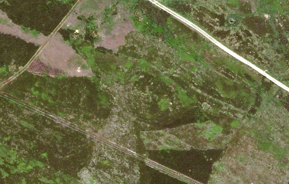
Aerial image, 2002Aerial image, 2009
The “length of banking” he described didn’t seem apparent when we visited the site yesterday (23.3.09), but we intend a further exploration of this and the adjacent monuments in the coming weeks and hope to locate it!
Interestingly, the archaeologists Faull & Moorhouse (1981:1:103), in their otherwise fine survey, actually doubted this place as having any prehistoric status, without giving any reason why—which was a big mistake. No doubt they spent too much time in offices and board meetings instead of getting out a bit more! Unless evidence to the contrary can be strongly presented, this site must be classed as undoubtedly prehistoric in nature (Bronze Age or Iron Age certainly) and almost certainly had something to do with rituals of the dead.
Great Skirtful Ring embankmentSouthern edge of the ring
From outer edge to outer edge the ‘ring’ measures 102 feet across, N-S, and with a rough maximum 101 feet E-W, being diameter, being some 300 feet in circumference. When you look at the site at ground level it appears to be an almost perfect ring, consisting of an embankment little more than 2 feet high at the most, with entrances both east and west. However, as the aerial images show, the perfect circle aint quite so perfect! But at ground level, there’s a certain uniformity about it. The embankment is in very good condition around much of the ring, with only slight damage in certain parts. The western opening strongly implies a direct relationship with the Great Skirtful cairn — which would infer this monument to have more of a ritual nature rather than the simple domestic enclosure, inferred by Colls and Cowling. Adding to this we find a tumulus 100 yards east and the remains of several other cairns nearby, making the site almost hemmed in by death-sites. A prehistoric cemetery is a short distance further down the moorland slopes to the east. Add also the fact that the Burley Moor stone avenue runs immediately south and the death-motif has to be increased.
What do I think it is? Not sure! The thought that it’s a previously unrecognized henge has crossed my mind…but henge monuments aren’t things that I’m very clued-up on, so wouldn’t like to say for sure. If there are any university archaeology students out there who are into getting their feet dirty, give this site a look-over. It’s intriguing, in very good condition, and could do with an accurate ID!
References:
Bennett, Paul, The Old Stones of Elmet, Capall Bann: Chieveley 2001.
Colls, J.N.M., ‘Letter upon some Early Remains Discovered in Yorkshire,’ in Archaeologia, volume 31, 1846.
Cowling, Eric T., Rombald’s Way, William Walker: Otley 1946.
Faull, M.L. & Moorhouse, S.A. (eds), West Yorkshire: An Archaeological Survey – volume 1, WYMCC: Wakefield 1981.
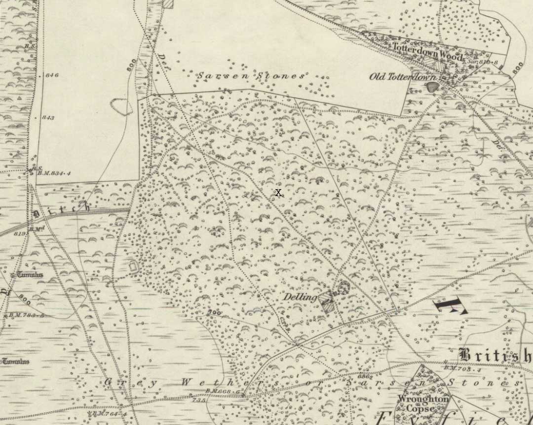
We were fortunate and taken here by the renowned local megalith authority, Pete Glastonbury – but without Pete’s help you might be ambling here and there for quite a while. It’s on the eastern side of The Ridgeway, down the slope past the stone known as The Polisher, across the flatland sea of many rocks until it begins rising again a few hundred yards east. Where a long straight embankment rises up a few feet (a boundary line), the rock’s just a few yards above it. Walk back and forth around here and you’ll eventually find it!
Archaeology & History
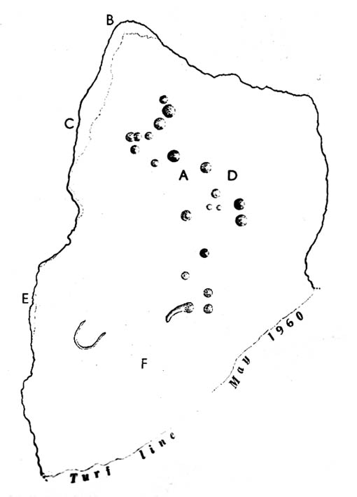
Lacaille’s 1962 sketch of the carving
Archaeologist A.D. Lacaille (1962) appears to have been the first person to have written about this little-known site, describing it as being “between the south-western corner of Totterdown Wood and Delling Cottage.” Here is what he described as, “a cluster of unmistakably artificial and mostly well-preserved cup-markings on the smooth south-easterly sloping surface of a recumbent sarsen.”
And from the photos accompanying Lacaille’s article, it obviously looked a decent carving as well — and so it has transpired. Lacaille (1963) briefly mentioned the carving again a year later in his lengthier essay on the nearby Polisher Stone up the slope a few hundred yards away. But then Wiltshire’s only known cup-marked stone was all-but ignored by archaeologists and left in the literary wilderness until, years later when rock art became a fad in such circles, regional archaeologists Pete Fowler & Ian Blackwell (1998) described the carving as “a cluster of several round depressions…each about two inches across”; though incorrectly ascribed it as the “southernmost example” of cup-marked stones outside of Cornwall.¹ Another rock-art student known as Mr Hobson, following his excursion to the site with the regional authority Pete Glastonbury, wrote:
“The cups themselves are very smoothed out, and fit the bill from the drawing. The horseshoe is very evident, as is the ‘slug’ mark, possibly a half-finished groove from one of the cups near the horseshoe. There are also some angular, yet serpentine (?) grooves at turf level on the south side of the stone. These look like they might be enhanced natural marks in places.”
The rock itself isn’t in its original position, having been moved from another point very close by (probably only yards away). It is sited on the edge of an old boundary line — which made me wonder whether the ‘U’- or ‘C’-shaped ingredient in the carving was a later addition, perhaps of one of the old land-owners hereabouts. The cups however, seem typical of the thousands that we find in northern Britain.
The isolation of this carving is rather anomalous. Others should be in the area but archaeo-records are silent (though the majority of Wessex archaeologists are academically illiterate when it comes to identifying such carvings). The carving may simply be the product of nomadic northerners, showing what their tribes do ‘up North’, so to speak. However, considering the tough nature of southern sarsen stones, it’d have taken ages to etch just this one stone. You can visualise it quite easily: southern tribal folk looking on, somewhat perplexed, as a northern traveller tried to convey what they etch on their stones in the northern lands, only to struggle like hell with cup-marks they’d do with ease on the softer rocks of their homelands. Wessex tribes-folk may have watched, seen the trouble their traveller had over such inane and (perhaps) meaningless carvings, and didn’t see the mythic point s/he was trying to convey…
Curious ‘U’ or ‘C’-shaped feature
Or maybe not!
The lesson with rock-art tends to be simple: where there’s one carving, others are nearby. The rule aint 100% of course — but when we were here the other day I was wanting to dart here, there and everywhere to check the many thousands of outcrop rocks that scatter this entire area. Us rock-art nuts tend to do things like that. It’s a madness that afflicts…
There were one or two stones with ‘possible’ single cup-markings on them, but I wasn’t going to start adding them to any catalogues. They were far too questionable. I was wanting something a bit more decent than that. And then, when Mikki, June, Pete, Geoff and I got to the collapsed long barrow known as the Devil’s Den a few hundred yards further down this rock-strewn sea of a valley, there was something with a bit more potential that we came across…
Folklore
In recent years this cup-marked stone has already attracted imaginative notions, with little foundation. Archaeologists Fowler & Blackwell (1998), in their otherwise fine book, think this carving was related to goddess worship, describing how,
“On Dillion Down…the Great Mother’s help was permanently invoked by patiently indenting a special stone with symbols of her potency.”
Adding that this “was a new idea brought in from the North, and Fyfield was the only place to have such a stone.” Weird! I could’ve sworn there were plenty of other rocks between here and there!
References:
Fowler, Peter J., Landscape Plotted and Pieced: Landscape History and Local Archaeology in Fyfield and Overton, Society of Antiquaries London 2000.
Fowler, Peter & Blackwell, Ian, The Landscape of Lettice Sweetapple, Tempus: Stroud 1998.
Lacaille, A.D., ‘A Cup-Marked Sarsen near Marlborough, Wiltshire,’ in Archaeological Newsletter 7:6, 1962.
¹ Along with the cup-markings atop of Devil’s Den a few hundred yards to the south, across in Somerset we had the Pool Farm example; there are a number of examples in Dorset, including the Badbury Rings carving; plus others in Devon, etc.
Stone Circle (destroyed): OS Grid Reference – NT 774 292
Also known as:
Five Stones
The Tryst
Archaeology & History
Less than a mile northwest of the hillfort on Linton Hill, modern OS-maps show the field-name of ‘Five Stone Field’ which is where, in bygone years, another important stone circle once stood. Today unfortunately, not a single stone remains. As the Scottish Royal Commission (1956) lads told:
“About a mile NE of Frogden, on the N side of the road between Frogden and Greenlees, there were formerly five or six upright stones forming a circle, ‘about the size of a cock-pit’ (1792 Statistical Account). This circle, which was adopted as a rendezvous by Border raiders in the Middle Ages and became known as The Tryst, has long since disappeared, but its approximate site is indicated on the OS map by the name Five…Stone Field.”
Folklore
One of many stone circles used as an old moot, or gathering spot. This was described in one of the many footnotes to Sir Walter Scott’s (1802) Minstrelsy of the Scottish Border, in which he told:
“At Linton, in Roxburghshire, there is a circle of stones surrounding a smooth plot of turf, called the Tryst, or place of appointment, which tradition avers to have been the rendezvous of the neighbouring warriors. The name of the leader was cut in the turf, and the arrangement of the letters announced to his followers the course which he had taken.”
This tradition was echoed around the same period in Robert Forsyth’s (1805) massive work on the history of Scottish life and landscape, saying:
“In different parishes, such as Moorbattle, Linton, and others, are to be found what are called tryst stanes. These are great stones commonly situated on high grounds. They are placed perpendicularly in rows, not unfrequently in a circular direction. It is said, as also the name imports, that in times of hostility they marked the places of resort for the borderers when they were assembling for any expedition of importance.”
References:
Burl, Aubrey, The Stone Circles of Britain, Ireland and Brittany, Yale University Press 2000.
Forsyth, Robert, The Beauties of Scotland – volume 2, Thomas Bonar: Edinburgh 1805.
Royal Commission on the Ancient & Historical Monuments of Scotland, Roxburghshire – volume 1, HMSO: Edinburgh 1956.
Scott, Walter, Minstrelsy of the Scottish Border, James Ballantyne: Kelso 1802.