Very little appears to have been written about this site, due no doubt to lack of archaeological investigation aswell as the destructive powers of intense agricultural practices hereby. It was first described in the Yorkshire Archaeological Register and told about by a Mr. H.G. Ramm, who told us of,
“a probable cursus in the Scales, Fimber Grange and Fimber Station area. An aerial photograph taken by John Dent has entended parallel ditches previously known in fragmentary form and enabling them to be interpreted as a cursus running along the valley floor, the north ditch from SE 8939 6106 to SE 9075 6104 and the southern ditch from SE 8937 6103 to SE 9068 6102. The distance between the ditches varies from 18-27m west of Fimber Grange to 30-37m east of the Grange. A trapezoidal enclosure, 30m by 15m, possibly a small long barrow, has been identified at SE 9008 6104, oblique to the north cursus ditch, which bends to take in account of it. A group of five ring ditches, three of which are in the cursus, lies to the west of Fimber Grange, but indicate a wartime searchlight post.”
This makes the length of this monument pretty short, but the faint remains of this possible cursus are visible on aerial shots. A number of other large ancient earthworks were charted here by the famous archaeologist, J.R. Mortimer (1905), though he made no mention of this particular site.
More info please!
References:
Edmondson, T., History of Fimber, H. Smithson: Malton 1857.
Gutch, Mrs. E., Examples of Printed Folk-lore Concerning the East Riding of Yorkshire, David Nutt: London 1912.
From junction 49 on the A1 (M), Dishforth turn-off, bear west on the Copt Hewick and Ripon road. 100 yards past Copt Hewick, take the track on the right-side of the road, leading to Blois Hall and further up to Low Barn. Once at Low Barn, go north through the trees called Harland’s Plantation and the barely visible henge remains are in the field on the other side – as PeteG’s fine aerial photo here shows!
Archaeology & History
At ground-level there’s not too much to see of this once fine henge, thanks to the usual excesses of modern agriculture and modern industry. Which is a pity, as the completed monument here was similar in size and lay-out to the three huge henges a few miles north at Thornborough. Archaeologist Jan Harding (2003) believes this and the Thornborough henges and others nearby, suggests “there was a unity of purpose behind” all of them, in terms of their lay-out, alignments and ritual purpose. He may be right. Aubrey Burl thinks similarly, noting how,
“The central plateau of these enclosures are remarkably similar in shape and size, slightly ovoid and varying no more than 5 metres or so from a norm of 97 by 92 metres. All have their entrances near the northwest and southeast following the lie of the land.
Each of them could have held as many as two thousand people and yet they crowd together in a narrow rectangle 11km (7 miles) long and no more than 1.5km (1 mile) across, like an avenue of architect-designed houses with a river frontage to their west.”
Intriguing stuff – and all from the neolithic period. But focussing on Hutton Moor’s monument, …
In Walbran’s (1851) historical work on Ripon and district, he gave us one of the earliest descriptions of Hutton Moor’s henge, telling:
“we have far more direct and conclusive evidence, that the immediate vicinity of Ripon was regarded with peculiar interest and veneration ; since one of the tribes of the Brigantian Celts had chosen it as their station for the dispensation of justice and the celebration of religious rites ; in fact, had made it the seat of their government. This position — novel as it may be — is, I believe, sufficiently proved.by a remarkable earth-work on the high land near ” Blows Hall,” commanding extensive prospects up and down the Vale of Ure, as well as of the distant ranges of hills which form the side screens of the great Yorkshire plain. Like Abury and Stonehenge, which it rivals in antiquity, its outline is that of a circle, of which the diameter is not less than 680 feet ; but no stones remain, nor indeed does that material seem to have been used in its formation. Though recent agricultural operations have partially effaced the regularity and proportion of its plan, it is sufficiently evident that it was enclosed by a lofty mound and corresponding trench — the latter being inside, and a platform or space about thirty feet wide intervening.
“…At two opposite points, bearing nearly north and south, the mound and trench, for about the space of twenty-five feet, have been discontinued, in order to form an approach to the area of the temple. Outside the mound, also, are some slight vestiges of a further avenue, but too indefinite to be traced. But, however obscure the denotation of its several parts may have become, the antiquity and purpose of the place, as a temple for the performance of Druidical rites, is satisfactorily ascertained by the existence of at least eight large Celtic barrows in its immediate vicinity ; one of which, being on the very ridge of the vale, and planted with fir trees, forms a conspicuous and useful object to guide a stranger to the site. Two of these barrows were opened five years ago, but I found nothing but a few calcined human bones, the ashes of the oaken funeral pile, and some fragments of flint arrow-heads, such as are still used by the North-American Indians. Several bronze spear-heads and celts have, however, been found in the neighbourhood, within recollection.”
Walbran also described there being some upright stones at the henge:
“two small pyramids or obelisks, built on the mound of the temple, about fifty years ago, in the place, it is said, of two similar erections, apparently of high antiquity.”
Loveday (1998) addressed some interesting notes about potential alignment features at henges first described in Anthony Harding’s (1987) text, Hutton Moor included — i.e., the angle of their respective entrances/exits very closely mirror the alignment of adjacent Roman roads. Curious correlates akin to the ley hunter’s assertions find the alignment or direction of nearby Roman roads is echoed in the alignments of henge entrances. Now this wouldn’t seem too unusual, but in 4 out of 5 henges, this peculiar parallel has been found. The Hutton Moor henge is no exception; with its aligned entrances closely paralleling the ancient straight Roman road of the A1 (though there are evidences of a pre-Roman track preceding the Roman construction), less than a mile to the east. The same alignment is echoed in all of the Ure Valley henges.
Folklore
Ley alignment at Hutton henge
This is a site that seems to have been laid out in some form of linear arrangement in prehistoric times. The notion was first posited in Norrie Ward’s (1969) work, but later expanded in Devereux & Thomson’s (1979) survey of prehistoric alignments. Although the axis of the henge doesn’t line up with other sites surveyed, they include it in what’s known as the “Devil’s Arrow’s Ley” and the western side of the henge lines up with the Devil’s Arrows and other sites along the line. When this ley was assessed for statistical probability, Robert Forrest found the alignment to have a probability much greater than that of chance.
References:
Atkinson, R.J.C., “The Henge Monuments of Great Britain,” in Atkinson, Piggott & Sandars’ Excavations at Dorchester, Oxon, Ashmolean Museum 1951.
Standing Stone (destroyed): OS Grid Reference – NS 759 351
Archaeology & History
The name of the place sort of gives the game away, but sadly we’ve got nowt to see anymore as the forest has covered it. The Royal Commission lads came here in 1971 and couldn’t find it, but later told that it “formerly stood on the summit” of the said hill. An important geomantic spot without any shadow of a doubt, probably having some relationship with an old tomb, either here or around the tree-covered summit of Tod Law, due east of here.
There’s a great deal more that’s been forgotten about up and about this region which will come to light as visits unfold.
References:
Royal Commission on the Ancient & Historical Monuments of Scotland, Lanarkshire, HMSO: Edinburgh 1978.
All sorts of ways to get here – all via road I’m afraid. Those southern-types aint into walking over fields and ambling about like we can do ‘ere up North. Best way to get here really, is get to Chipping Norton (a good little town with many good folk there), and ask! Take the road out of the town to Over Norton, taking the first road left as you enter the village. Go along this country lane for a mile until you reach a crossroads at the top of the hill. Turn right at the crossroads and watch out for the parking space at the roadside a few hundred yards along. Stop there and walk through the gate to go round to the other side of the trees. (if there’s a Rollright Trust member there loitering in the entrance asking you for some money to walk or sit by the stone circle – don’t give ’em it! They’ve used the cash for poisoning the wildlife in the past (killing the moles, field mice and other indigenous creatures there) and then lied about what they did (reckoning it was nowt to do with them!), so I wouldn’t trust them).
Archaeology & History
Southern arc of stones
There’s masses to be said on this site, which can’t possibly be added all in one go (I’ve literally got a full unpublished book on the many aspects of this lovely site) — so this entry will be updated occasionally with additional bits and bats of info and images as time floats by.
This remarkable and quite atmospheric megalithic complex has so much to say for itself that entire books have been written on the place (see the extensive references below), dealing with its archaeology, folklore and ritual use. I was very fortunate around the turn of the 21st century, to be able to live in an old hut that used to stand in the copse of trees just outside the circle, where I had numerous weird and wonderful experiences with people, wildlife, and what some might call the more eosteric life of the place…
1920s Ground-planMr Taunt’s 1907 plan
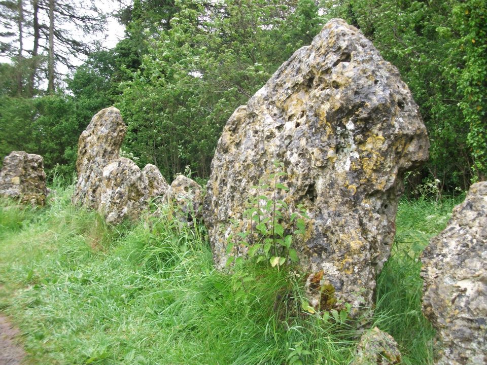
The King’s Men is a near-perfect circle of oolitic limestone uprights. Thought for centuries to be the memorial site of some victory by the Danish King Rollo, they have been described by many historians, travellers and antiquarians from the 14th century upwards. Several early writers described a sort of “avenue” running from the circle, not unlike the one perceived at Stonehenge and elsewhere. Evidence for this cannot be fully disregarded, as there are some recumbent monoliths along the road beside the stone complex, known as the Jurassic Way. This was a prehistoric trade route and it is more likely than not that some other uprights would have been nearby.
The Rollright Stones were used as the prime base for what was known as the Dragon Project: an exploratory examination of potential electromagnetic anomalies that were recorded at the standing stones here by scientists, geomancers and archaeologists who were involved daily monitoring work over many years. Much of this was published in Paul Devereux’s book, Places of Power – required reading for everyone who pretends an interest in megalithic sciences.
Northern section of the ring
The Rollright complex today consists primarily of three sites: the Whispering Knight’s portal dolmen, the King’s Men stone circle, and the King Stone. Of these, it is the stone circle which draws most attention. Several alignments are connected with the complex. The original ritual use of the place would have, primarily, involved rites of passage and death rituals; though it seems obvious that menstrual rites were also an important social event here. After dark, this stone circle has distinctly ‘female’ spirit, sometimes manifesting in a quite wrathful form (please don’t confuse any of the modern witchcraft mythos with such things – they are fundamentally different in both social and ritual aspects). Women obviously played a large part in the ritual use and geomantic layout of the original complex. It also seems likely that the stone circle was used as a moot spot, which may have been in use until medieval times. The recent discovery of the carving of a family crest, at least 500 years old, implies this.
Until Tom Wilson and I lived in the hut at the circle in the 1990s, previous reports of ‘carvings’ at the stone circle were few and debatable. But two of the stones in the Rollright circle have quite distinct carvings on them. The most pronounced is etched on the tallest stone (stone 1 – Barnatt Survey) and comprises of a typical heraldic shield – although we cannot, as yet, ascertain the motif in the middle of the shield. This was first seen by a visiting tourist who wanted to remain anonymous, but the finding was written up in an article I wrote shortly afterwards. (Bennett 1999) The image below – reproduced courtesy of Alistair Carty’s Archaeoptics Limited laser scanning company – clearly shows the carving, which confirmed the initial discovery. The report of his findings can be read here.
Not unsurprisingly, since the discovery of the shield various screwy interpretations have been put forward to account for the design. My favourite has to be the one suggested by a pagan friend of the Rollright Trust, who, occult-like and all secret (y’ get the drift) reckoned it was all to do with King Arthur! Needless to say, my response of, “Y’ talking bollox mate!” was received somewhat nervously by pagan Karin Attwood and the twee little entourage who were discussing the shield, in the usual ‘secrecy – secrecy’ hush-hush tone of false witches and similar idiots!
A few months later I found another set of carvings on stone 62 (Barnatt survey), comprising a set of Ogham letters. These Ogham are very faint and are best observed before midday, when lighting conditions highlight them much clearer. If anyone can decipher them, it would be greatly appreciated. (though please don’t gimme some shit about King Arthur)
Folklore
Folklore ascribes that the number of stones in the complex cannot be counted (a motif found at other megalithic sites) and, intriguingly, of the surveys done here, no two are the same! One early illustration of the circle shows 30 stones, nother describes 46, and one survey describes just 22 stones! As the 20th century progressed the numbers increased dramatically, with surveys differing at 58, 60, 71, 72, 73, 77 and 105. The present-day ‘guesstimate’ is about 77. Weird!
Folklore tells that if you can count the stones three times in a row and get the same number, you may have any wish you choose. But recently this has become reversed and it is said to be a curse if you count three times the same. Intriguingly, modern visitors who allege no superstitious beliefs, will not count the stones a third time if the same number crops up twice.
The best-known folk tale of this place is of the King, his men and the knights, who “were once men who were changed into vast rocks and fossilised,” as Camden first put it in 1586. The King’s men sometimes go to drink at a well near Little Rollright, as does the king, but he only goes at certain times. At midnight however, on certain days, the King’s Men have sometimes been known to come to life, join hands and dance in a circle. This sounds more like a folk remnant of ritual use here.
Faerie folk are said to live beneath the circle, in great caverns, some of which are linked up to the single monolith across the road. Ravenhill [1926] described how local folk had sometimes seen the little people dancing around the circle by moonlight, but nobody has seen them of late.
References:
Anonymous, The Rollright Stones: Theories and Legends, privately printed, n.d.
Anonymous, ‘Oxfordshire Mysteries,’ in The Ley Hunter 86, 1979.
Aubrey, John, Monumenta Britannica, Milbourne Port 1980.
Barnatt, John, Stone Circles of Britain (2 volumes), BAR: Oxford 1989.
Bennett, Paul, ‘Remarkable Carving found at the King’s Men Stone Circle, Rollright, Oxfordshire,’ in Right Times 5, 1999.
Bennett, Paul & Wilson, Tom, The Old Stones of Rollright and District, Cockley Press: London 1999.
Bloxham, Christine, Folklore of Oxfordshire, Tempus 2005.
Bord, Janet & Colin, The Secret Country, Paul Elek: London 1976.
Bord, Janet & Colin, A Guide to Ancient Sites in Britain, Paladin 1979.
Brooker, Charles, ‘Magnetism and the Standing Stones,’ in New Scientist, January 1983.
Burl, Aubrey, A Guide to the Stone Circles of Britain, Ireland and Brittany, New Haven & London 1995.
Burl, Aubrey, Great Stone Circles, Yale University Press: New York & London 1999.
Burl, Aubrey, The Stone Circles of Britain, Ireland and Brittany, Yale University Press 2000.
Clayton, Peter, Archaeological Sites of Britain, Weidenfeld & Nicolson: London 1976.
Cooper, Roy, ‘Some Oxfordshire Leys,’ in The Ley Hunter 86, 1979.
Cowper, B.H., ‘Oxfordshire Legend in Stone,’ Notes & Queries (1st series), 7, January 15, 1853.
Crawford, O.G.S., Long Barrows of the Cotswolds, John Bellows: Oxford 1932.
D., A.J., ‘Rollwright or Rollright,’ in Notes & Queries, 2nd series, 7, 1859.
Devereux, Paul, ‘Is This the Image of the Earth Force?’ in The Ley Hunter 87, 1979.
Devereux, Paul, ‘Operation Merlin,’ in The Ley Hunter 88, 1980.
Devereux, Paul, ‘Operation Merlin 2,’ in The Ley Hunter 89, 1980.
Devereux, Paul, ‘The Third Merlin,’ in The Ley Hunter 92, 1981.
Devereux, Paul, Places of Power, Blandford: London 1990.
Devereux, Paul, The Sacred Place, Cassell: London 2000.
Devereux, Paul, Steele, John & Kubrin, David, Earthmind, Harper & Row: New York 1989.
Devereux, Paul & Thomson, Ian, The Ley Hunter’s Companion, Thames & Hudson: London 1979.
Dyer, James, Discovering Regional Archaeology: The Cotswolds and the Upper Thames, Shire: Tring 1970.
Evans, Arthur J., ‘The Rollright Stones,’ in Trans. Bristol & Glouc. Arch. Soc., 40, 1892.
Evans, Arthur J., ‘The Rollright Stones and their Folklore (3 parts),’ in Folklore Journal, 1895.
Graves, Tom, Dowsing, Techniques and Application, Turnstone: London 1976.
Graves, Tom, Needles of Stone, Granada: London 1980.
Graves, Tom (ed.), Dowsing and Archaeology, Turnstone: Wellingborough 1980.
Gray, William, The Rollright Ritual, Helios: Cheltenham 1975.
Grinsell, Leslie V., The Ancient Burial Mounds of England, Methuen: London 1936.
Grinsell, Leslie V., The Rollright Stones and their Folklore, Toucan Press: Guernsey 1977.
Hamper, W., ‘Observations on certain Ancient Pillars of Memorial, called Hoar Stones,’ in Archaeologia, 25, 1833.
Hawkes, Jacquetta, A Guide to the Prehistoric and Roman Monuments in England and Wales, BCA: London 1973.
Higgins, Geoffrey, The Celtic Druids, Rowland Hunter: London 1829.
Krupp, E.C., In Search of Ancient Astronomies, Chatto & Windus: London 1979.
Lambrick, George, The Rollright Stones: The Archaeology and Folklore of the Stones and their Surroundings, Oxford Archaeology Review 1983. (Reprinted and updated in 1988.)
The Cambridge biologist J. Havelock Fidler described finding three standing stones in the gorgeous little remote hamlet of Toscaig in his book Ley Lines (1983), which neither the Applecross Local History Society, myself, nor anyone else has been able to locate (the OS grid reference cited above is simply an approximation of their locality). In an updated version of his work, Mr Fidler seems to indicate they can be found a short distance south-east of the village, at the end of an alignment which is supposed to start at Fearnmore (NG 724 605), at the northern edge of the peninsula. If they exist, could anyone perhaps enlighten us as to their whereabouts…?
References:
Fidler, J. Havelock, Ley Lines – Their Nature and Property, Aquarian: Wellingborough 1983.
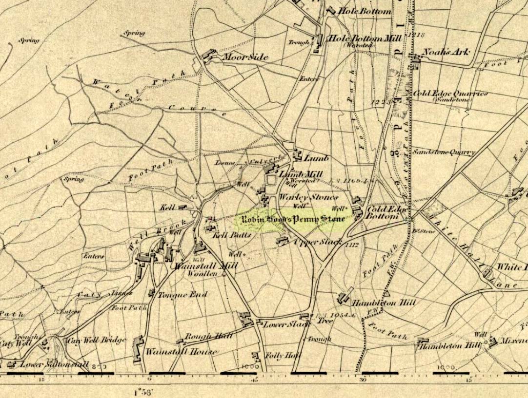
Stone Circle (destroyed): OS Grid Reference – SE 046 288
Archaeology & History
The Pennystone on 1852 map
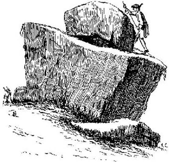
All remains of this site, first mentioned as a stone circle in 1836, have gone. The place could be found by the appropriately named Stone Farm at the top end of Wainstalls and was first mentioned by John Watson (1775), who strangely said nothing about any circle here. However, this changed when John Crabtree (1836) arrived and described a ring of stones surrounding a large boulder in the centre (illustrated here). The boulder itself was actually called the Robin Hood Penny Stone.
Folklore
Watson’s 1775 drawing
This was one of the many legendary sites from where our legendary outlaw practiced shooting his arrows. He was also said to have picked up and thrown a large standing stone from this spot, until it landed three-and-a-half miles away on the hillside on the other side of the Calder Valley. (this was known as the Field House, or Sowerby Lad Standing Stone)
Crabtree, John, Concise History of the Parish and Vicarage of Halifax, Hartley & Walker: Halifax 1836.
Dobson, R.B. & Taylor, J., Rymes of Robyn Hood, Alan Sutton: Gloucester 1989.
Faull, M.L. & Moorhouse, S.A., West Yorkshire: An Archaeological Guide (4 volumes), WYMCC: Wakefield 1981.
Varley, Raymond, “A Stone-Axe Hammer, Robin Hood’s Penny Stone and Stone Circle at Wainstalls, Warley, near Halifax,” in Yorks. Arch. Journal 69, 1997.
Watson, John, The History and Antiquities of the Parish of Halifax, T. Lowndes: London 1775.
From Litton Cheney go north up the White Way road until it meets the main A35 crossroad. Go across the road, then get over the fence on your right and onto the rise in the hill. These earthworks, or timber circle remains, are under your feet!
Archaeology & History
Lay-out of site by O.G.S. Crawford, 1939
Shown on modern OS-maps as an ‘earthwork’, but ascribed elsewhere as a timber circle, when Stuart & C.M. Piggott visited and surveyed this site in the 1930s, they thought it to be the remains of stone circle. Found on a prominent rise in the landscape with excellent views all round here, the Piggott’s description of the site told:
“It consists of a shallow ditch with internal bank, enclosing a somewhat oval area measuring 75 feet from north to south, and 63 feet from east to west. The ditch, which lies on the southeast, where the ground has been disturbed, does not reach a depth of more than about one foot, while the bank rises nowhere above 2.5 feet. It is possible there was an entrance on the southeast, but the bank is disturbed at this point. On the crest of the bank on the southwest are 3 almost circular depressions, some 6 feet in diameter, and placed 20 feet distant from one another along the circumference of the bank. Another similar depression is on the northeast, while yet another may have existed in the disturbed portion of the bank on the southeast.”
It was these finds which led them to suppose a ring of stones originally surmounted this small hillock, twelve in all.
Ground-plan by O.G.S. Crawford
Another site — which they called ‘Litton Cheney 2’ — was found less than 50 yards to the east of here by a Mr W.E.V. Young and the Piggotts. These remains comprised of, “a very shallow and regular ditch surrounding a circular area 47 feet in diameter. A single sarsen lies on the inner lip of the ditch on the southeast” which, they thought, may have been the solitary remains of yet another stone circle. Three other sarsen stones were found 90 feet south of here, but they were unsure whether they related to the circle or not.
Archaeological remains from here dated from 2200-1400 BC and local researcher Peter Knight (1996) thought that the sites ascribed here as megalithic rings to be correct. He also found that tumuli visible some 5 or 6 miles southeast of here, on top of Black Down Hill (where the Hardy Monument’s found), “marks out the winter solstice sunrise.” A dip in the horizon to the northwest, he claims, also marks the summer solstice sunset from here. Knight also mentions how “both Litton Cheney sites lie close to a ley line going to the Nine Stone Circle and beyond.”
References:
Knight, Peter, Ancient Stones of Dorset, Power: Ferndown 1996.
Piggott, Stuart & C.M., ‘Stone and Earth Circles in Dorset,’ in Antiquity, June 1939.
The best way to get here it is to head from the Cow and Calf Hotel up the hillside to where the great rock is sticking out (the Pancake Stone). From here, head straight onto the moor toward the Idol Stone — close to the Idol Rock which you can see 400 yards south in front of you. From here, follow the footpath up the hill before you and keep on the path towards Lanshaw Lass. About 100 yards on, turn straight west into the heather and keep your eye towards the south. About 250 yards on, about 100 yards away from the Green Crag Top cup-marked boulder, you’ll see it!
Archaeology & History
One of very few solitary standing stones on Ilkley Moor, and one which I relocated after The Old Stones of Elmet (2001) had gone to press — which was a great pity. Nearly four feet tall, this is a good chunky monolith which stands close to being on line with the summer solstice alignment from the nearby Twelve Apostles stone circle. (I was gonna call it the Summer Stone, but thought better of it!)
There’s another recumbent stone, more than five feet tall when erected, 200 yards northwest of here. (This is also very close to being in line with with our chunky monolith, plus the Twelve Apostles. Anyone out there with a GPS who can check if this possible alignment is the last remnant of a summer solstice stone row? It probably isn’t, but it’d be good to find out.) On the same moorland level, heading back down, when the heather’s burnt back you’ll find a number of prehistoric tombs along the edge of the ridge. These don’t appear to be in the archaeological registers.
Found a few miles south of Banbury and running in a southeast to northwest alignment, Paul Devereux wrote that,
“the crop marks of this cursus fragment were first photographed by James Pickering in 1972…between the villages of East Adderbury and Bodicote…close to the River Cherwell. The southeast end is square; the other terminus is unknown.”
References:
Pennick, Nigel, & Devereux, Paul, Lines on the Landscape, Hale: London 1989.
There’s two real ways to get up here: one from the Oban-Kilmartin roadside; the other from Ford village. I’d go for the latter as it avoids the traffic. Walk up the track to Salachary from the village centre, heading west. It’s a gradual uphill climb and after about half-a-mile (past six or seven cup-marked rocks) the great hill rises to your left. Dun Dubh is to your right. Climb over the fence and head for the hilltop.
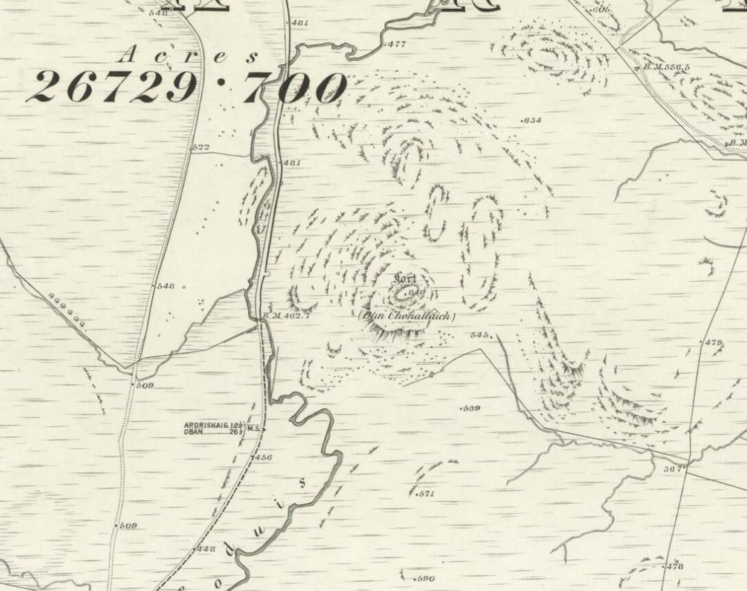
Archaeology & History
It’s my opinion that this fort, above all others in the region apart from Dunadd, was of paramount importance to our prehistoric ancestors. The reason being that it’s the great pyramidal hill to which the line of tombs in the Kilmartin Valley align, three miles to the south. This prehistoric alignment was quite intentional (if you’ve got your doubts, gerrup there & have a look for y’self — you’ll soon change yer mind).
Curious carved stone found here
The main part of the structure is an irregularly-shaped construction with walling on all sides, measuring about 40 yards by 20 yards. Much of it is pretty well defined – though has been vandalized by various doods in the past: one bunch being a film-crew who used the site in the early 1980s! Inside the main walled fortress are several ruins. The Royal Commission (1988) report told:
“Much of the interior is occupied by a rock spine which is surmounted by a modern cairn, but the NW half is relatively level and it contains, in addition to the modern round-house…and and an S-shaped structure associated with film-making, a number of ruined stone foundations. On the north side there is a rectilinear building, and between the modern round-house and this rectilinear building, there is a further structure…an arc of walling, but its precise shape cannot now be determined without excavation.”
Dun Chonallaich means “the fort of King Connal’s people,” and although much denuded, is well worth the clamber for a short archaeological day out. A curious “gaming-board” was found here (see photo). A portable cup-marked stone in the fort’s southern wall is a modern artifact.
It’s a lovely view from up here too. This is one of many places I’ve sat during a raging thunderstorm. One helluva buzz, believe me!
References:
Gillies, H. Cameron,The Place-Names of Argyll, David Nutt: London 1906.
Royal Commission for Ancient & Historic Monuments, Scotland, Argyll – volume 6, HMSO 1988.


")


")

")