Holy Well (destroyed?): OS Grid Reference – NS 7787 9252?
Archaeology & History
A small but ancient chapel once existed in Cambusbarron, long ago, located about one hundred yards east of the Chapel or Christ’s Well. William Drysdale (1904) told that, apart from the Chapel Well and nearby St. Thomas’ Well, “several other wells in the locality were believed to possess healing virtues.” It was J.S. Fleming (1898) who said that, “attached to Cambusbarron Chapel two other holy but nameless wells are stated to have been in existence in 1866, on the brink of Glenmoray Burn, near the chapel itself.”
A writer for the Stirling Observer in 1871 told that one of these holy wells was in fact to “be seen near the brink of a little burn which trickles from the miniature glen of Glenmoray, visible on the hillside, just below the lowest reservoir” above Touch, more than a mile away (heading up towards St Corbet’s Well). The other was said to be near Johnnie’s Burn, a mile to the west. In Fleming’s (1898) opinion however, neither of these sites were feasible, as he walked all along the course of both burns and could find no other wells. Does anyone know any different?
References:
Drysdale, William, Auld Biggins of Stirling, Eneas Mackay: Stirling 1904.
Fleming, J.S., Old Nooks of Stirling, Delineated and Described, Munro & Jamieson: Stirling 1898.
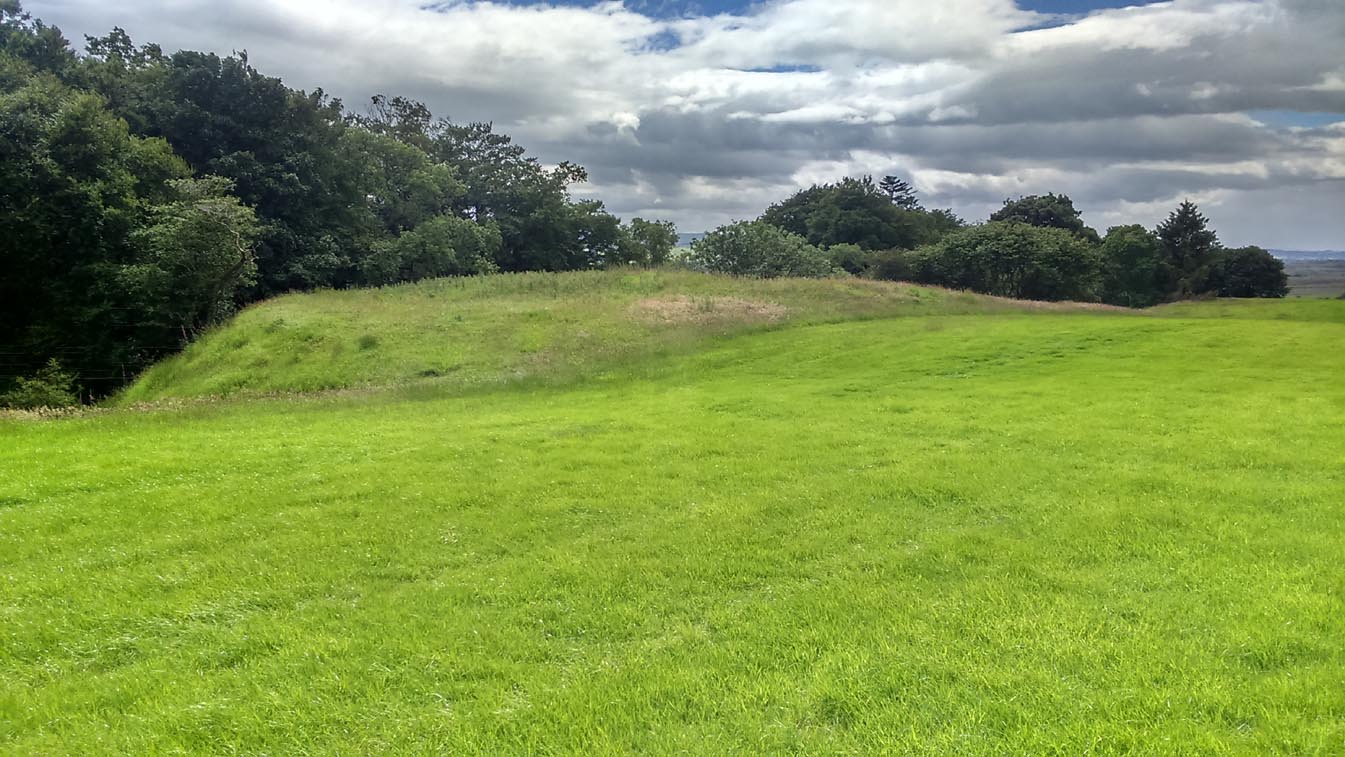
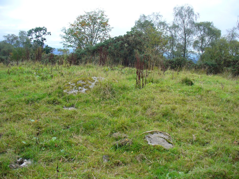
Take the A873 from Thornhill to Aberfoyle, and literally 1 mile west of Thornhill turn right up the track up and past Easter Borland farm (as if you’re heading up to Auchensalt). 250 yards past the farm, a large field opens up. Walk 100 yards east along the side of the wall towards the trees and follow the tree-line upstream 250 yards (don’t go into the lovely little glen) until, on your right, you’ll see a reasonably large area of grassland that rises up, with a steep-ish slope down to the burn below. This is the remains of the broch.
Archaeology & History
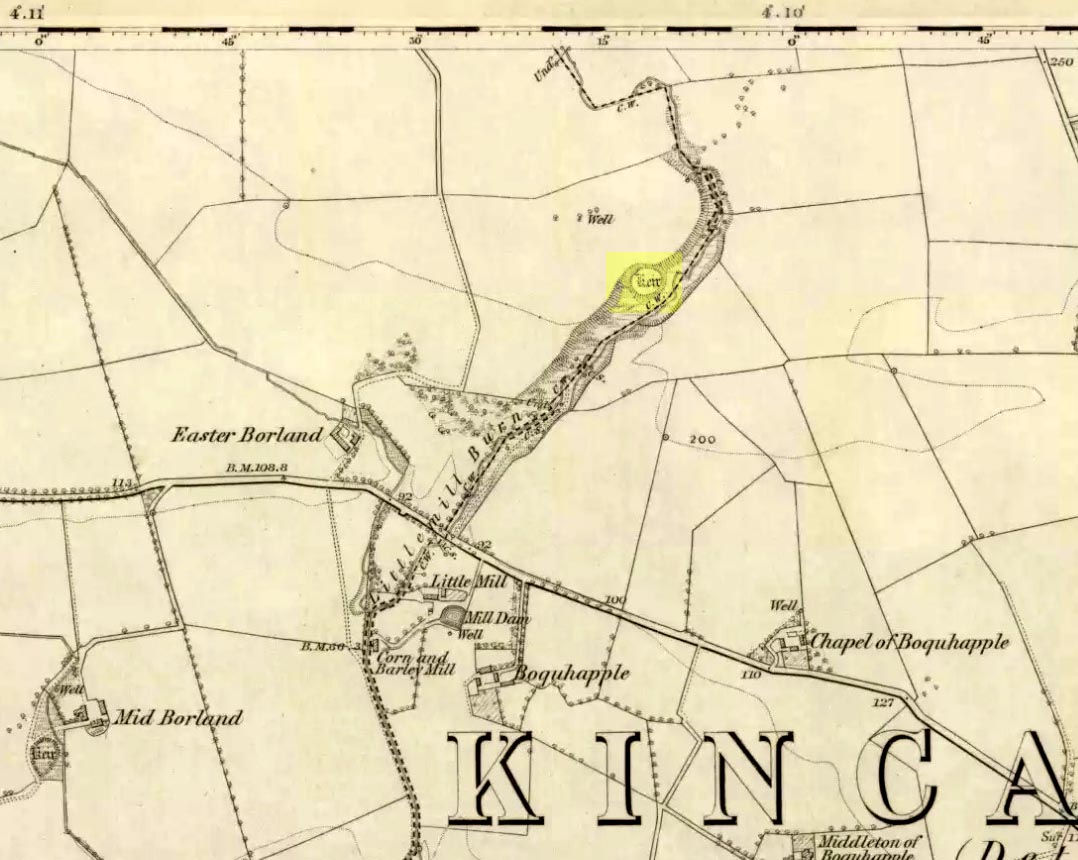
Shown as a ‘Keir’ on the 1866 OS-map, this is an old Scottish dialect word, barely used at all nowadays (folk need to start using it again!) which meant “an ancient fortification” or “rude forts”. The word is mentioned in early Statistical Accounts in 1795 and in the Second Account of 1845 the “Kiers at Auchinsalt” are mentioned specifically, albeit in passing….
Auchinsalt ‘Keir’ on 1866 map
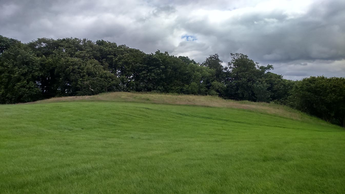
When we visited the site yesterday, very little could be seen due mainly to the summer vegetation covering the area. A very small section of open walling was noted on its western side, and beneath the undergrowth a roughly oval structure was in evidence on the rise between the edge of the field and the drop into the small glen below. Something obviously man-made lies beneath the grasses, but in the last 100 years or so there has been debate as to whether it was a fort, a dun or a broch. The consensus at the mo, tells Euan Mackie (2007), is that it’s a broch!
Auchinsalt broch, looking east
Measuring some 25 yards across, the walling that makes up the broch was between 4-6 feet wide all round, and about 2 feet high. There seemed to be aggregates of large scattered stones inside and outside the main oval feature. If there was an entrance, it seemed to be at the western side, but I wasn’t sure about this. In truth, unless you’re a hardcore broch fanatic, you’d be truly disappointed with the dilapidated state of this monument. Much better ones can be seen just a few miles away…
References:
Chrystal, William, The Kingdom of Kippen, Munro & Jamieson: Stirling 1903.
Grant, William (ed.), The Scottish National Dictionary – volume 5, SNDA: Edinburgh 1960.
MacKie, Euan W., The Roundhouses, Brochs and Wheelhouses of Atlantic Scotland c.700 BC-AD 500, BAR: Oxford 2007.
Along the A84 road betweeen Callander and Lochearnhead, take the small road west when you reach Balquhidder Station, towards Balquhidder village. Go along here for 1½ miles (2.5km) as if you’re gonna visit the Puidrac Stone; but 200 yards past this, go through the gate on the south-side of the road into the boggy field for about 150 yards towards the River Balvag. You’re looking for several stones, as in the photos. You’ll find ’em. (you may get soaked though!)
Archaeology & History
The stones, looking NW
After many thousands of years, this innocuous-looking group of small stones found in the very boggy field immediately west of the Puidrac Stone looks nothing like it once did. Some modern academics would have you think there was nothing here of prehistoric interest, but oral tradition and earlier writings tell otherwise. Although not shown on the early OS-maps, it was first described in James Gow’s (1887) articulation on the antiquities of the area, in which he told:
“A short distance east from the present (Balquhidder) parish church, in the haugh below the manse, there are seven stones remaining of a circle which appears to have been about 30 feet in diameter; only one stone is in its original upright position, but there are fragments of others lying about; as usual, they are known as “Clachan-Aoraidh,” or worshipping stones, and are not likely to be disturbed during the lease of the present tenant.”
Looking E, with Puidrac Stone just visible left of telegraph post
A few years later when Thomas Ross (1919) visited the area with a Prof Cooper and others, they reported the single standing stone still in position and the anglicized name of the Worshipping Stones was still in evidence amongst locals.
Arc of fallen stones by the trees
Nowadays the site is in ruin. Two of the stones stand out when the rushes aren’t too high, with one earthfast and its companion prostrate; but as you can see in the photo (right), there remains a sunken arc of two other stones laid down, running away from the larger ones, with a fifth overgrown and nearly covered by vegetation and the young trees. In all probability, tradition is probably right here: this is the remains of a stone circle.
Folklore
The field in which these denuded megalithic remains are found, was, wrote Thomas Ross (1919),
“the site of a long-popular market called ‘Feill Aonghais’, i.e., St Angus’ Fair. It was held, according to Mr Campbell, in May; according to Mr Gow, on “the Saint’s Day, the 6th of April.” It was quite the custom…to hold a fair after divine service on the Patronal Feast. The folks came to “kirk and market” on the same day, and mixed good fellowship and manly sport with their worship and their business.”
If you were to hold a fair there nowadays, likelihood is it would get flooded! Christian myths tell of a “St. Angus” taking over whatever the heathen traditions were in this domain, more than a thousand years back.
The archaeology and traditions ascribed to this ancient tree (exact position unknown) is based on words that were first penned two hundred years ago. It was thankfully recorded with a reasonable description when William Nimmo wrote about the great Sir William Wallace in the second edition of his Stirlingshire (1817) work. Known about in oral tradition by local people, Nimmo told how:
“Torwood was a place where he and his party, when engaged in any expedition in this part of the country, often held their rendezvous, and to which they retreated in the hour of danger. Here is still to be seen an aged oak, well known by the name of Wallace’s Tree; which seems to have been, even then, rotten and hollow within, and is said to have often afforded a lodging to him and a few of his trusty friends. It is supposed to have been one of the largest trees that ever grew in Scotland. It is now almost quite decayed; but, from its ruins, appears to have been of an uncommon size. The remaining stump is no less than eleven or twelve feet in diameter. It stands upon the summit of a small eminence, which is surrounded on all sides by a swamp. A rugged causeway runs from the south through the swamp, and leads up to the tree. Some other vestiges of the stonework are discernible, surrounding the tree in a circular form, and leading to the conjecture that this oak is of a very high antiquity; and that, having been much frequented by Druidical priests, amongst whom the oak was sacred, the causeway had been laid for their approach to it, and the performance, underneath its branches, of religious rites.”
Nimmo may have a point here. Not necessarily of druids (although druidic traditions and reality is known from many old tracts to have continued in many of the hidden places in Scotland), but certainly in relation to the paved track leading to a what may have been a recognised moot-hill, on top of which this great oak once stood. Great trees and ancient meeting places were held in high esteem, not only in the legends of druidism and more established animistic pantheons, but in the recognised pragmatism of local tribal gatherings, in Scotland, Wales, England and in traditional cultures all over the world. (Gomme 1880) The traces of stonework leading to the hill strongly implies an archaeological site in the paving alone; but moreso, as an important site in the traditions of the Scottish people. The fact that these stone ruins were still visible when Nimmo visited the site in the latter-half of the 18th century in the context he describes, implies it may have been the remains of a possible crannog; or a moot hill; or even, with its great oak surmounting, a sacred grove! In my mind, it was probably being used as a gathering place long before William Wallace and his men gathered here…
In 1880, a 3rd edition of Nimmo’s Stirlingshire was published and edited by R. Gillespie. Herein were additional notes about Wallace’s Oak that had been uncovered by Mr Gillespie. Although he’d visited the place,
“Not the smallest vestige…of the Wallace oak remains. Even the ” oldest inhabitant” can say nothing of it save what he has gathered from tradition. Sir Walter Scott, in his Tales of a Grandfather, speaks of having seen some of its roots eighty years ago; and recently we were shown a treasured morsel of the tree in the Chambers’ Institute at Peebles. Wallace, undoubtedly, often chose the solitude of the Torwood as a place of rest for his army, raised and roused to oppose the tyranny of Edward. Here he concealed his numbers and his designs, sallying out suddenly on the enemy’s garrisons, and retreating as suddenly when afraid of being overpowered. While his army lay in these woods, “the oak” was his head-quarters. Within it, the illustrious hero generally slept, the hollow trunk being huge enough to afford shelter both to himself and one or more of his associates.”
When John Gibson (1908) came to write about it, he told that “Wallace’s Oak, which stood on another part of Woodside (low Torwood), has…vanished.” No roots, no lingering trunk—nothing. But although the tree has long since gone, William M. Stirling pointed out in 1817 that,
“A young tree is pointed out in the neighbourhood, as having sprung from an acorn of Wallace’s Oak.”
If and when we can locate the old toll-house of Broomage at Larbert, we get much closer to identifying the exact location of this long lost oak. Then, perhaps, a commemorative plaque should surely be placed there to remind people of their great history, and included on tours of sites relating to Sir William Wallace.
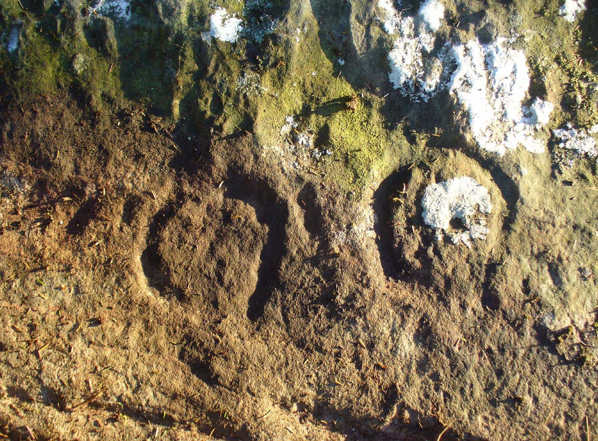
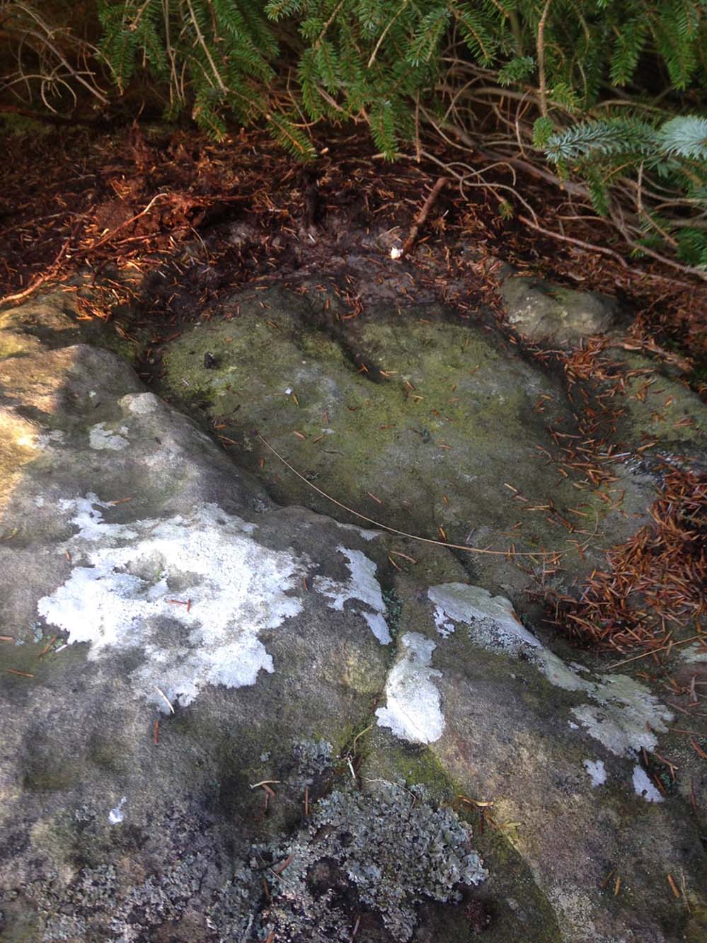
Take the A811 road between Stirling and Kippen and go up into Gargunnock, From the village centre, go along the Leckie Road (not the Main Street!) for half-a-mile, then turn left up the tiny road. ¾-mile (1.15km) along, a small bridge crosses the Leckie Burn (a.k.a. St Colm’s Burn). Walk up the footpath into the woods for 100 yards or so and cross the waters. When you see the large overgrown rocky rise of the Leckie Broch covered in pesky rhododendrons, walk up its left-side and, as it levels out, note the walling on your left. It’s just a few yards along.
Archaeology & History
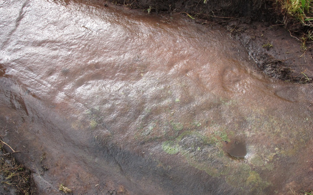
This cup-marked stone is only for the mad petroglyphic puritans amongst you! Rediscovered by Nina Harris on February 5, 2017, it can be seen when you look at the main southern wall of this rhododendron-infested broch, near the middle of one of the large cut-and-squared stones built into the upright face. The carving has at least two cup-markings on its vertical face—which are clearly visible on the photo. One is quite deep, whilst the other is quite faint. At either end of the stone are what may have been two other cups that were started but never finished, or just natural-occurring holes in the stone (I’m more of the opinion that they’re just natural, but would love to be wrong!). A possible third cup-mark can be seen along the top-edge of the stone.
There is no mention of this carving in Dr Mackie’s various writings on the Leckie Broch, which he excavated in the 1970s; only the recognised cup-and-ring stone (Leckie 02) on its northeast edge. The intriguing element (which can also be applied to the Leckie-2 carving) is that the Leckie Broch was constructed in the 1st century AD—and these cup-markings were probably carved around that time, much later than many others. It is likely that other unrecorded carvings will be hiding away nearby.
References:
MacKie, Euan, “The Leckie Broch, Stirlingshire,”, in Glasgow Archaeological Journal, volume 9, 1982.
Take the B822 Fintry to Kippen road and just over 2 miles (3.3km) north of Kippen, take the small country lane on your left. Parking is truly troublesome along here, so: nearly half-a-mile along, a road/track on your right takes you into the huge forestry plantation (or ‘tree farm’ as Nina Harris calls them). Go up here and, when you reach the tree-line, walk along the outer perimeter fence to your left. Keep walking – and walking – through bog and over fence – keeping all along to the outside of the forest for more than a mile. You eventually reach a rise on the Balfron side with huge views to the west – and just here is an opening into the trees on your right where a long ridge of rock is obvious. You’re here!
Archaeology & History
Main feature of the carving
Not far from the recently rediscovered Footsteps Stone (coming soon…), this large cup-and-ring carving was found by Paul Hornby on a TNA rock art venture in November 2016 on a journey to the petroglyphs on Balgair Muir, between Balfron and Fintry. Twas a damn good day indeed! We’d been up here the previous week, but the grey daylight gave little away. Upon revisiting the place, Paul eventually called us over and, beneath a mass of fallen tree foliage, the long raised rock gave up its ancient symbols once again.
Very faint partial cup&rings?Main feature, looking ENE (photo by Nina Harris)
Along the main face of the stone are a variety of geophysical undulations and small natural hollows—lots of them!—some of which give the impression of being primitive cup-markings, but they’re more the result of erosion. However, amidst these are several very possible cup-markings, and some photo-images show that at least one of them has portions of a distinct faint ring around it, possibly two of them. On the whole however, we’d need a geological specialist to tell us with certainty about the other doubtful ‘cups’ here (TNA neeeeds an in-house crazy geologist into petroglyphs and things!).
Balgair Muir Woods designMain feature, looking west
As the rock face slopes down on its northern edges, away from the many natural pits and nodules, Paul uncovered two large incomplete ‘rings’, each with short outer ‘lines’, distinctly carved. The ‘rings’ are somewhat larger than the average cup-and-ring motifs — but it also appears that at least one of the ‘rings’ is lacking an internal cup-mark.
Large semi-carved ‘bowl’ (photo by Nina Harris)
On the same piece of rock, several feet to the east and almost covered by an adjacent tree, we also found a large half-natural half-carved ‘bowl’ more than 12 inches (30cm) across with a possible cup-marking near its centre. Whoever carved this section of the petroglyph has definitely utilised the natural features in the rock and, it seems, may never have finished the work.
We need more visits to this area to find what more lies beneath the fallen forest debris.
Acknowledgements: Massive thanks to Paul Hornby for uncovering this carving. Huge thanks also to Nina Harris for her help and some of the photos; and also to Ann Rankin and Mick for all their relative help too. Until next time…
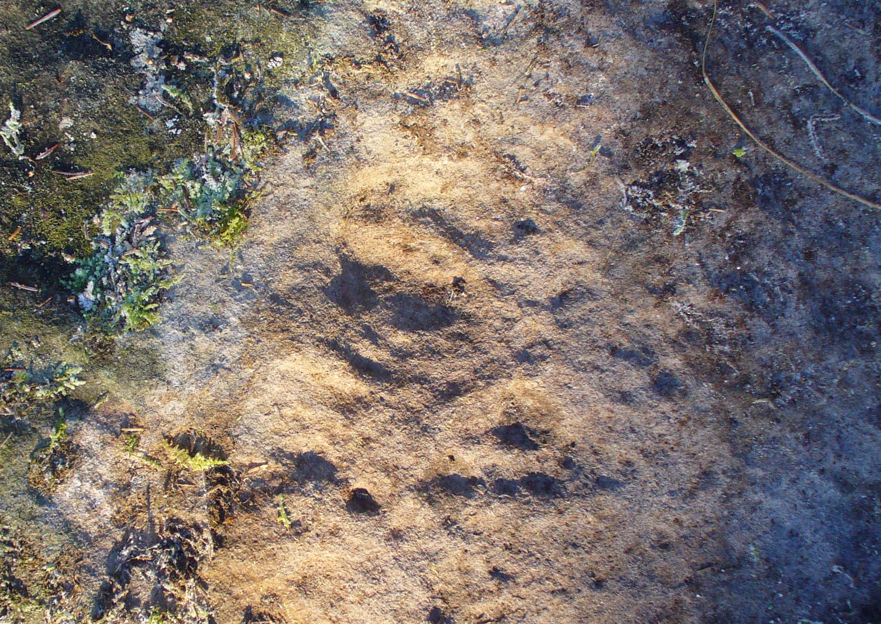
Take the same directions to locate the cup-and-ring stone of Ballochraggan 12. There are several rocks adjacent. The one immediately next to it, to the northeast, is the one you’re looking for. Be gentle and careful if you’re gonna look at it — deadly serious, be very careful indeed!
Archaeology & History
One of the most intriguing and most fascinating of all the prehistoric carvings I’ve yet to discover. Not that this was all my own work. If it hadn’t been for Paul Hornby, we might have simply walked past it as being little more than a single cup-marked stone—and in this area, single cup-marks tend to be little more than geological in nature.
After we’d looked over several of the registered carvings close by, I did my usual meandering back and forth, stroking stones and seeing if there were any carvings that had been missed by previous surveyors. And in walking past a small piece of smooth rock, a singular cupmark seemed to stand out. I walked past it, shouting across to my colleague.
“It looks like we’ve got a single cup-mark here Paul,” I said, “with possible half-ring.” Thankfully Mr Hornby gave it his better attention.
Mask Stone, with faint ‘urn’Close-up of features
The sun was still out and shining across the smooth rock surface, which tends to mean that you’re not seeing any carving on the stone quite as good as it actually is. Thankfully however, the sun was beginning to get lower and, when this happens, if we wet the rock, any carvings that might be there stand out much better. And this little fella just seemed to get better and more curious the more attention Paul gave it!
The first thing that became obvious were a series of faint carved lines above the single cup-mark. Initially these didn’t seem to merit much attention (straight lines on rock are usually more the product of geophysical action than that of humans), but as the rock got wetter, Paul saw something very distinct indeed.
“There’s a face on it!” he exclaimed. And indeed there was. A Rorschach response no doubt, but it was still very much like a face. This looked for all the world akin to the stylised olde English gentry sort of countenance, as in old cartoons. It was quite ‘distinct’, as such characters themselves insist on being! Yet around this initial face, more lines seemed to be emerging as the stone gave up more and more of its hidden story.
Standing back from an initial investigation, the carving was seen to consist of a triple-ring, but without the traditional ‘cup’ in its centre. Instead, the centre was marked simply by a small ‘dot’—perhaps, originally, being a small conglomerate hole formed as a result of another tiny harder fragment of stone falling away from its larger mass. But a ‘dot’ it was. The other carved ‘lines’ however, immediately below and attached to the triple-ring, gave us something almost unique—and another strong Rorschach response. As the photos clearly show, we have a distinct second ‘face’ made up of the same lines but in a quite different form. This ‘face’ has all the attributes we usually associate with pictures of mythical spirits, demons, or a mask—hence the name!
Paul took a series of fine photos, hoping that he could catch the image that our eyes could clearly see. And thankfully, his digital camera brought the image to life even better than our eyes did! The ‘mask’ is comprised of carved lozenge forms, akin to the more decorative ones we find at Kilmartin, and more especially around Newgrange, Ireland. We sat and talked about this: wondering and working out routes that we’d take over mountains and moors, from Ireland, to Kilmartin, then onto Ballochraggan, etching the same designs onto the rocks hereby and attaching similar mythic notions to them: of shamanism and kingship; underworlds and journeys—paradigms lost and certainly misunderstood in the non-polysemia of many modern academics.
Lozenges and rings
…The stone here was still slightly covered over and, beneath the loose grasses, another feature emerged of another petroglyphic rarity. At the topmost western side of the rock a straight line ran across the surface, seemingly marked by the hand of man, with a curious little line almost doubling back on itself for just an inch or so, and then feeling to run down the stone, towards the concentric rings and the face below. When we stood back and took the photos, this line and its tracer took on a form that I’ve only seen echoed in one of the Netherlargie tombs at Kilmartin, Argyll, 44.4 miles (73km) to the west. It is very distinct.
The beaker, rings & ‘face’
Spuriously ascribed as being ‘axe’ carvings (oh how archaeologists love this Rorschach projection), the Netherlargie North tomb cover-stone in Kilmartin has a series of burial ‘urns’ or beakers carved onto the rock, amidst a scattered collection of cup markings. (Beckensall 2005:73-4; Bradley 1983:92-3; Royal Commission 1971:68-70; Twohig 1972, etc) Here too at Ballochraggan we find another such symbol, but just a singular example, much larger and more clearly a beaker or urn, as are traditionally found within many old neolithic and Bronze Age tombs; although no tomb is immediately apparent at this Ballochraggan carving.
The entire carving is very faint indeed (you can’t even see it when you’re looking directly at it unless conditions are good) showing that it remained open to the elements for thousands of years. Other adjacent carvings lack the erosion that we find on this one, even on those which, as archaeologist Lisa Samson said, is “softer sandstone rock than this one”—implying that it’s one of the older carvings in this incredible cluster.
References:
Beckensall, Stan, The Prehistoric Rock Art of Kilmartin, Kilmartin Trust: Kilmartin 2005.
Bradley, Richard, Altering the Earth, Society of Antiquaries Scotland: Edinburgh 1993.
Royal Commission on the Ancient & Historical Monuments of Scotland, Argyll – volume 6: Mid-Argyll and Cowal, HMSO: Edinburgh 1971.
Twohig, Elizabeth Shee, The Megalithic Art of Western Europe, Clarendon: Oxford 1981.
Acknowledgments: Huge thanks again to Mr Paul Hornby for his considerable help with this site, and for use of his photos.
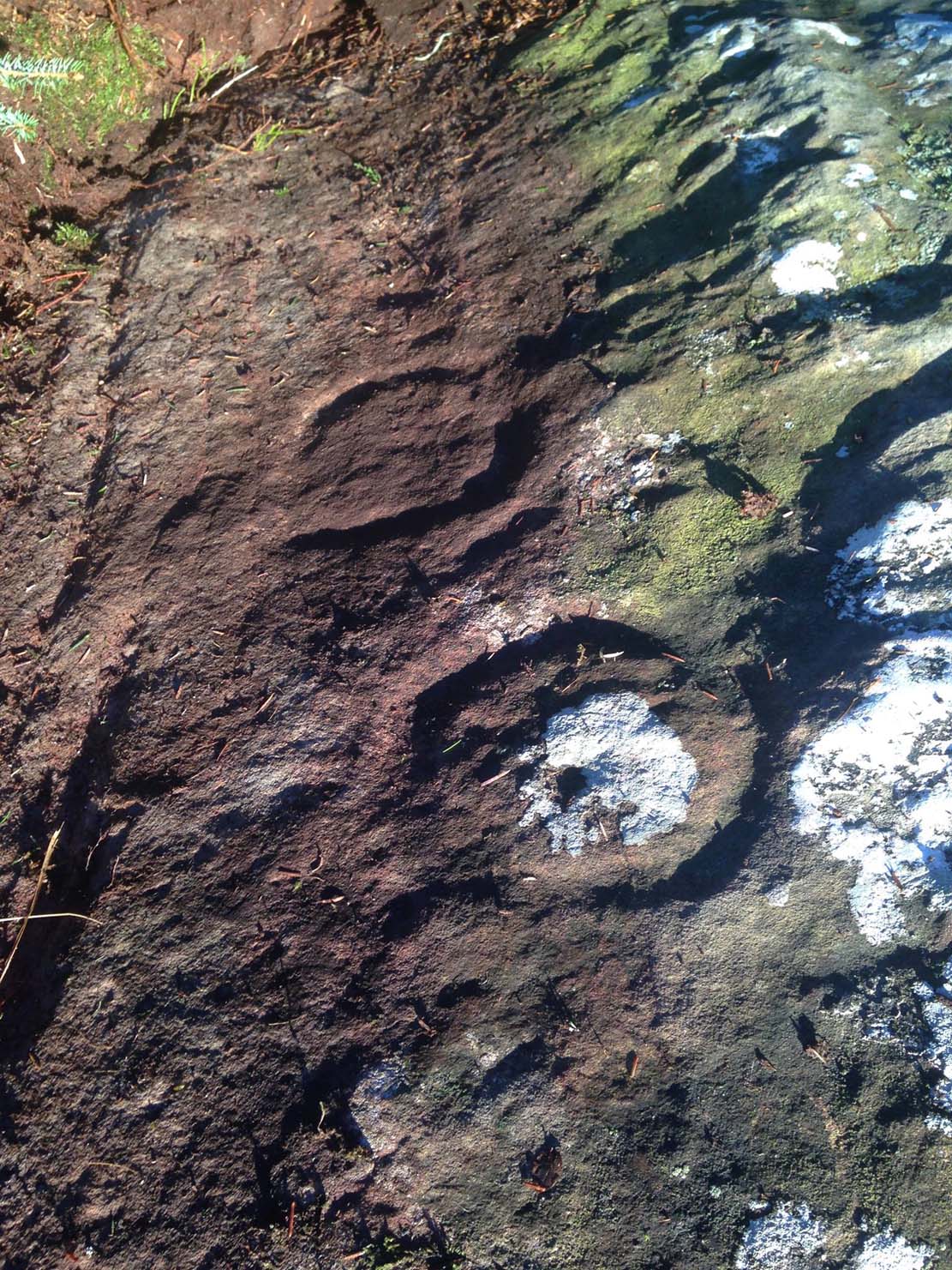
On the A81 road from Aberfoyle to Strathblane, about a mile south of Aberfoyle take the tiny right turn (keep your eyes peeled!) to Gartmore. At the end of the village, turn right at the T-junction. Just over a mile along the tiny road, just over the tiny road-bridge, turn right again up up the dead straight road to Drymen for nearly a mile and park up. A dirt-track is on your right: walk along here for ¾-mile (1.2km) and in a large field on your left a huge rock sits (no carvings on it). Keep walking on the track and where the field ends, a path to your left runs above a small burn. Naathen, 150 yards along here, look down at the waters and there’s a clump of large rocks. Check ’em out!
Archaeology & History
Morris’ old photo (from PSAS 1967)
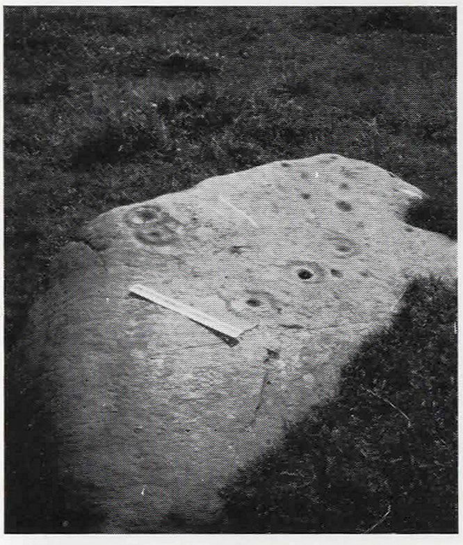
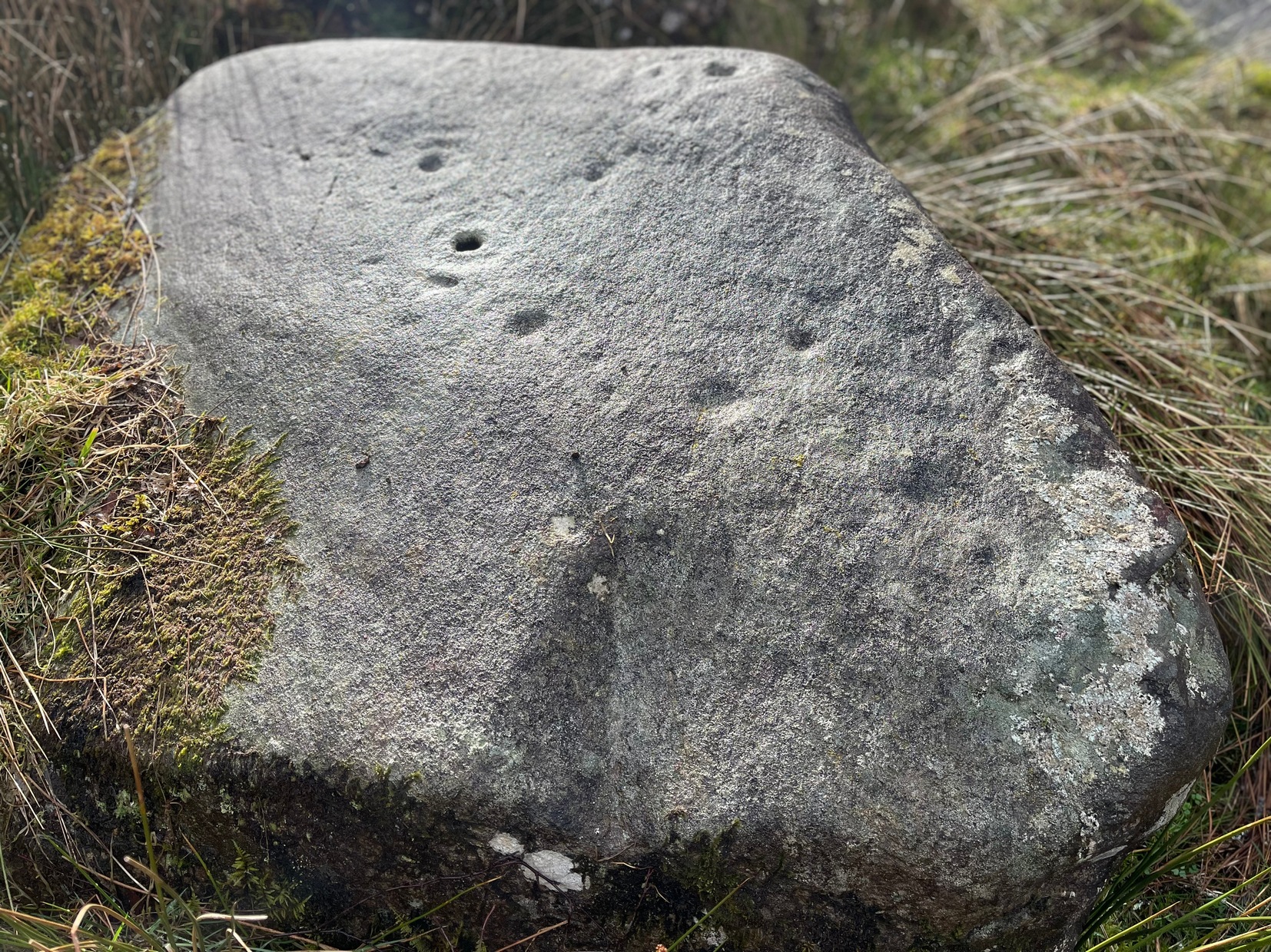
This stone and others were mentioned in MacNair’s (1973) essay in the popular history guide to the region, after it had seemingly been rediscovered a few years earlier by Ron Morris (1967; 1969), who listed it in his petroglyph catalogues. It was originally located at the top of the slope above the burn, but was rolled down here shortly after Morris discovered the cup-and-rings on it. The farmer at the time had made a bore-hole into the rock with the intention of blowing it up, but Morris found it just in time and the stone managed to survive!
Faint CnR’s just visible
It’s a large rock with a decent ornate design that was clearly visible when Morris surveyed it (see photo, right). It comprises of, “a cup-and-two-rings, 18cm (7in) diameter, 6 cups-and-one-ring (2 of which are tangential) and at least 8 cups. All rings are complete. Greatest carving depth 2cm (¾in).” There also appears to be a line of four or five small cup-marks running in a short line by one of the lower cup-and-rings, but these are very faint indeed. The double cup-and-ring mentioned by Morris is the one at the top-centre in my photo, but the next cup-and-ring down may also be a double-ring. At the top-right of the photo is where two cup-and-rings are conjoined.
Since being rolled down the slope to the side of the burn, the carving’s much more in the shadows and is more difficult to work out. Sadly on the day when I visited here, Nature bestowed on me a wet and cloudy firmament, so the design was even more difficult to see, as my photos illustrate.
Morris (1981) told that “other stones in the immediate vicinity bear possible cup-marks,” and one of these may exist just a couple of stones away (Corrie 2), leaning up into the grasses: this is another rock that has been pushed down the slope and has curious natural cup-markings on it, with one or two that could be man-made, but we need a geomorphologist to have a look at it and tell us one way or the other.
References:
Edlin, Herbert L. (ed.), Queen Elizabeth Forest Park, HMSO Edinburgh 1973.
MacNair, A.S., “History,” in Edlin’s Queen Elizabeth Forest Park, HMSO 1973.
Morris, Ronald W.B., “Stirlingshire: Corrie Farm (Gartnabrodnaig) – Cup Marks,” in Discovery & Excavation, Scotland, 1967.
Morris, Ronald W.B., “The Cup-and-Ring and Similar Early Sculptures of Scotland; Part 2 – The Rest of Scotland except Kintyre,” in Transactions of the Ancient Monuments Society, volume 16, 1969.
Morris, Ronald W.B., The Prehistoric Rock Art of Southern Scotland, BAR: Oxford 1981.
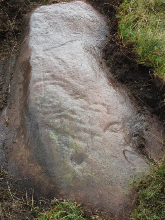
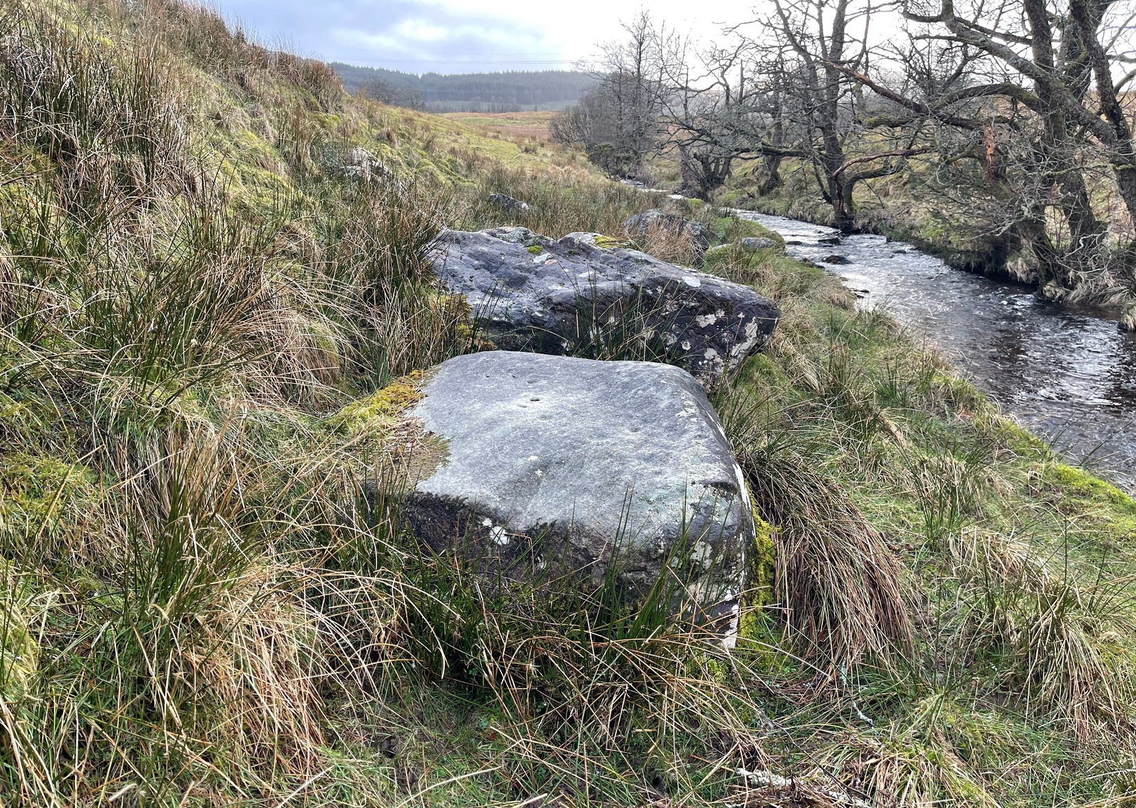
Take the same directions as if you’re gonna find the Pendreich Moor cairn up the hills behind and north of Stirling University (there are 2 very close to each other). Once upon the cairned hill, walk dead straight WNW for 100 yards or so, or down the slope into the small valley, then westwards. You’ll hit an overgrown length of very old walling. Keep walking along here and, below it, you’ll find these stones laying down in the shallow grasses on the south-side of the all-but dried stream. The large Cuparlaw Wood cairn is 0.4 miles west of here.
Archaeology & History
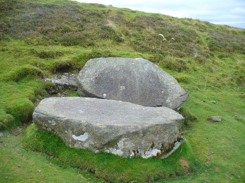
The Split Stone, Pendreich
This is something of an anomaly. There is no previous written history about the place (that I can find) and archaeologists and historians on The Prehistoric Society and CBA forums can offer no other explanation when asked: is this a standing stone that, many centuries ago, was cut and prepared to be erected, but never made it into the intended monument? (wherever that might have been) And so, I offer it onto TNA and ask the same of any readers, geologists or archaeo’s who might have an explanation for this curious, large split piece of stone, that lays silently on the western moorland edges of the Ochils, asking the same question.
When I first came across this site I was simply perplexed as to the why’s and wherefore’s of who had cut such a large rock into approximate halves. I must have walked around it many times, puzzling what the purpose would have been of doing such a thing, and how long ago the ‘split’ had been performed. About a year later I ventured up again and, when leaving to head back into Stirling, found no resolution to my puzzlement. It had me truly stumped!
It wasn’t until I visited the prehistoric Witches’ Stone about 15 miles away near Monzie Castle last year, that one of those ‘eureka!’ events occurred. The last thing on my mind was the curious split rock above Bridge of Allan. Fellow antiquarian Paul Hornby and I were taking photos of the Witches’ Stone, when one of us remarked how unusually flat and smooth one face of this upright standing stone was – in fact, incredibly flat and smooth – and that’s when it hit me! As I walked round and round the Witches’ Stone, the similarity between this upright example and the one laid on the ground about 15 miles away got stronger and stronger.
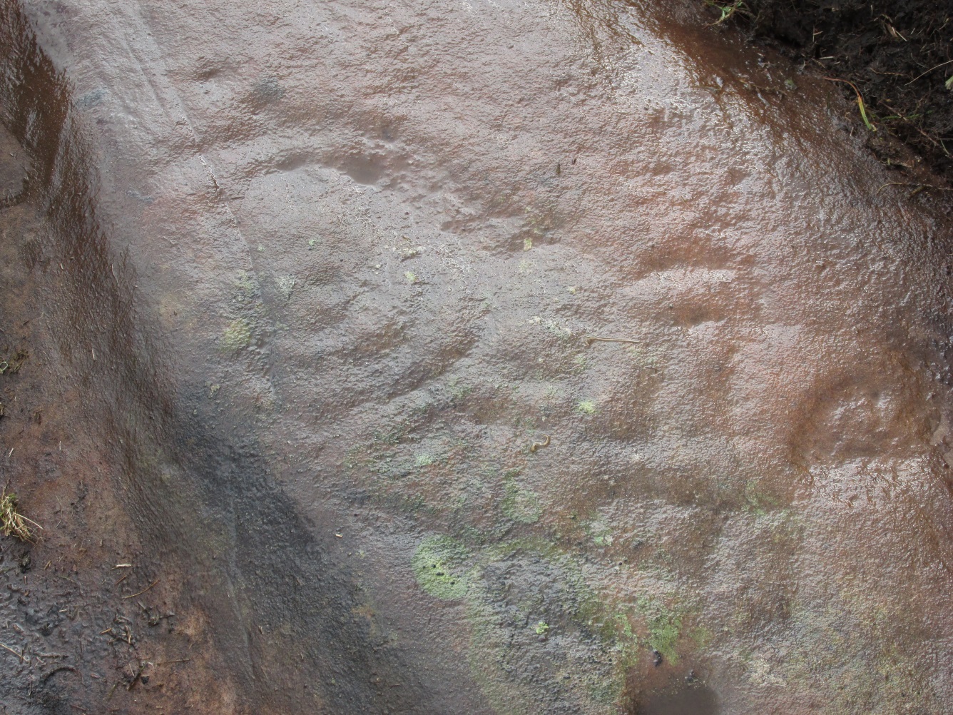
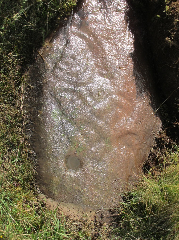
The Split Stone, looking east
A week or two later, archaeology student Lisa Samson and I went back to the Split Stone to have another look at it. Without doubt, the appearance and size and type of rock were one and the same. The only real difference between the Witches Stone and this Split Stone on the edge of Pendreich Moor, is that one stands upright and the other is laid down.
As you can see from the photos, we have a large rock, 5-6 feet long, which was, at some time many centuries ago, split almost straight down the middle, following a natural line of weakness or mineral deposit running through the stone. In all probability this was a standing stone prepared and ready to be used in some neolithic or Bronze Age monument not too far way—but for some reason it never made the journey to its intended spot.
The age of this split rock needs assessing correctly by geologists. Walking around the earthfast halves, it is difficult to see any recent evidence of mason marks that might help us determine when the rock was cut like this. In looking at erosion marks on cut-and-dressed quarried stone from post-medieval periods, we find no equivalent scars on this Split Stone. There is what may be faint evidence of some cuts into the stone at the top and side, but these are very debatable; and very probably it seems that the stone must have been cut a very long time ago, thousands of years back, in order to erode all obvious mason marks. But it would be good to get a geologist to have a look and confirm or deny such things.
…And, as if this isn’t a mystery unto itself: walk across the dried stream and go up the slope right in front of you immediately north. There’s a small, almost level ridge you’ll reach after 30 yards up, before the hill then rises further. If you notice, in the grasses and heather around you, there’s much more of the overgrown ‘walling’ here along this ridge—and some of it, with dips here and there and about three feet tall in places, is in a circle! It’s man-made, it’s a ring of stones, you can see it on GoogleEarth pretty clearly, and it’s not in any official record books.
From Bridge of Allan go down the main A9 road towards the University, but turn left up the Sheriffmuir road, 100 yards up turning right to keep you on track up the steep narrow dark lane, turning left at the next split in the road. Follow this for a mile or two all the way to the very end where the tell-tale signs of the unwelcoming english incomers of ‘Private’ now adorns the Pendreich farm buildings. There’s a dirt-track veering uphill diagonally right from here. Go up here and as it bends slightly left, look into the open copse of trees to the highest point here less than 100 yards to you right. That’s it!
Archaeology & History
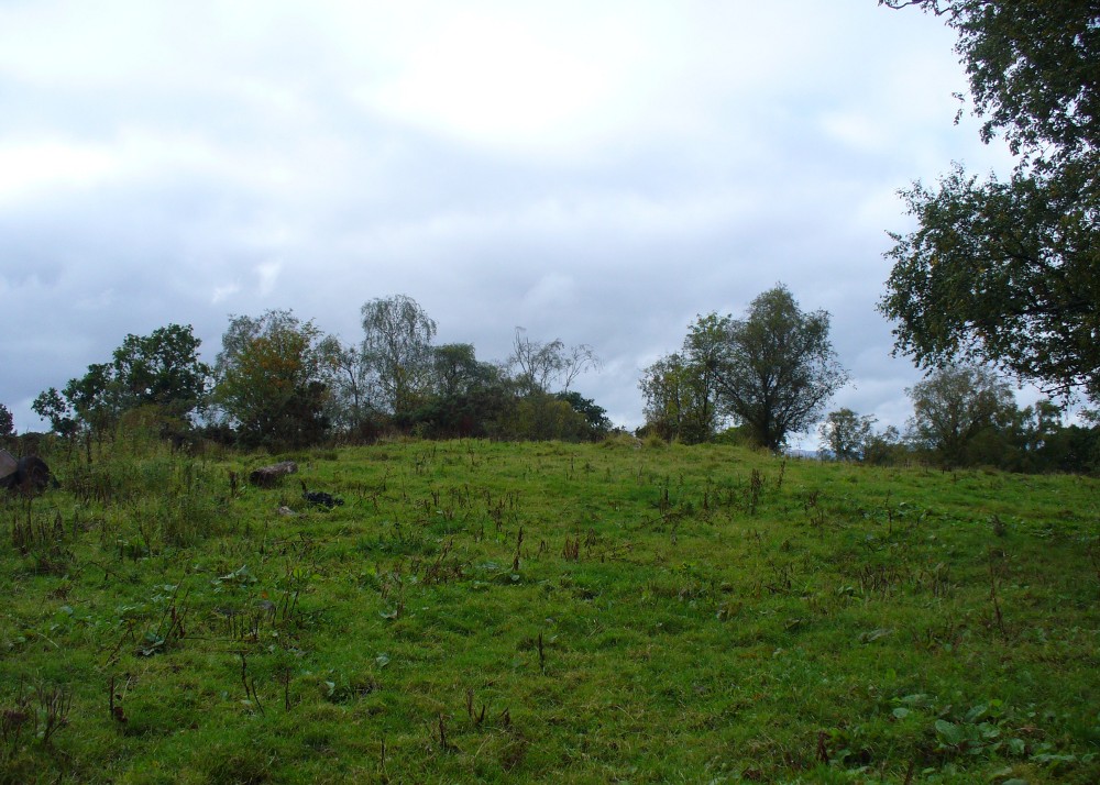
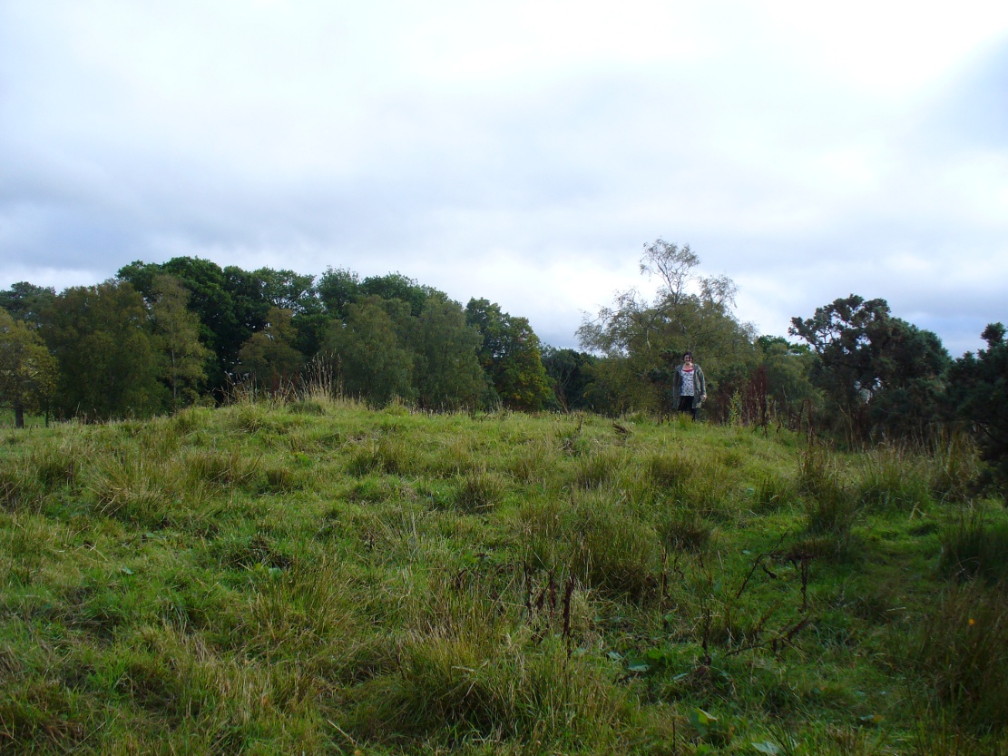
Lisa gives an idea of scale
The remains of this prehistoric tomb sits right on the very crown of the hill round the back of Pendreich, covered on its western edges by old gorse bushes. Its eye speaks with the nearby sites of the Fairy Knowe to the south, the fallen standing stone of Pendreich Muir to the northeast, the associated cairns to the east, and the Pictish fortress of Dumyat behind them. When I came up here for the first time last week with local archaeologist Lisa Samson, we found that the land upon which the cairn now lives is fertile with a variety of edible (Boletus, Amanita, etc) and sacred mushrooms (Panaeolina, Psilocybes, etc). And, despite being told by locals and the archaeology record as a place where very little can be seen, I have to beg to differ.
Fallen stone at the cairn edge
The crowning cairn is of course much overgrown and has been dug into in earlier years, but just beneath the grassy surface you can feel and see much of the stone that constitutes this buried site. The cairn itself rises a couple of feet beneath the grass and is clearly visible as you walk towards it. At its edges there seems to be the fallen remains of a surrounding ring of stones. Inside of this ring we can see and feel the overgrown rocky mass and open cists sleeping quietly, awaiting a more modern analysis to tell us of its ancient past. When the site was visited by the Royal Commission lads in the 1960s, they went on to tell us the following about the place:
“This cairn is situated on the summit of a low knoll within a felled wood, 170 yards ENE of Pendreich farmhouse at a height of 600ft OD. It consists of a low, grass-covered mound which measures 40ft in diameter and stands to a maximum height of 1ft 6in. The surface is disfigured by pits caused in 1926 when the cairn was opened and three cists were uncovered. Two of these contained no relics; in the third there were fragments of bones and a broken beaker, some sherds of which are preserved in the Smith Institute, Stirling.”
Although we find the scattered remains of old farm equipment lying round the edge of this tomb, it’s still a good site to visit and, I’d say, worthy of further archaeological attention.
References:
Royal Commission on the Ancient & Historical Monuments Scotland, Stirling – 2 volumes, HMSO: Edinburgh 1963.
Royal Commission on the Ancient & Historical Monuments of Scotland, Archaeological Sites and Monuments of Stirling District, Central Region, Society of Antiquaries of Scotland 1979.
Watson, Angus, The Ochils – Placenames, History, Tradition, Perth & Kinross District Libraries 1995.