Whether you come via Shipley Glen or Baildon, head for the Dobrudden caravan park on the western edge of Baildon Hill. As you get to the entrance of the caravan site, walk down (left) the footpath outside the park itself, looking across the grasslands, left, to the tree-lined wall a coupla hundred yards away. Head for that. Then go through the gate into the field where you’ll see a denuded line of walling, with what looks like some standing stones along it. That’s where you need to be!
Archaeology & History
First noticed on February 12, 2012, this simple cup-marked stone is another one that’s probably only of interest to the purists amongst you. Found below the southern end of Baildon Hill, due west of the lost Hope Farm cup-and-ring stone, the cup-markings here are on the north-face of an upright stone in an old wall. It’s obvious that this stone was once earthfast, when the carving faced the zenith or night sky, and has been cut in half and turned 90° making the cups more difficult to notice; and very obviously the rock was originally close to its present position in the walling.
Primary cupmark, right-side of stoneClose-up of cup/s
Found in an area rich in cup-and-ring stones, there’s just one singular cupmark that’s obvious on this stone; but as we looked back and forth, feeling the stone with our fingers, it seemed there may be a couple of others on the rock. We need to come back here again in better lighting conditions, as opposed to the old grey day She gave us yesterday, and see if the others are real or simple geological marks.
A prehistoric round barrow with an ancient literary pedigree, dating back to Anglo-Saxon records according to A.D. Mills (1989), when is was described in the boundary records of 833 AD as ‘on burg‘. It was described again in local records as Buleberwe in 1270, then more like the form we recognize today as the Bulbarowe in 1545, and variants thereof many times since then.
Measuring about 18 yards across and standing four feet high, Grinsell (1959) defined the monument as a ‘Bowl Barrow’, due to the shape of the mound. A brief description of the site by the Royal Commission (1970) lads told:
“Bulbarrow (77500574), bowl, lies at about 870ft above sea-level near the summit of the chalk escarpment, here known as Bulbarrow Hill. The centre of the mound has been dug into. Diameter 54tf, height 4ft.”
Grinsell and the Royal Commission both made note of a “sharpened bone of deer”, reported by Mr Woolls (1839), but pointed out there was an uncertainty whether the bone was dug “from this or the Bull Barrow in Holt” parish.
All early forms of the burial mound’s name strongly suggest it derived to a once great bull. The reason for this cannot be known for certain, but if we follow Conrad (1959) or Eliade’s (1986) rationale, the animal here was very likely a sacred bull — akin to the more famous Bull of Minos, or Apis, or Nandi. The religious importance of sacred animals was just as widespread in the British Isles as it was elsewhere in the world (examples of bulls relating to prehistoric remains scatter the British Isles with a similar association: see the Bull Stone, Guiseley; the Creagantarbh stones and hillfort, Argyll, etc.). It would be good to know of any local folklore relating to oxen or other bovines in the Woolland area.
References:
Conrad, Jack Randolph, The Horn and the Sword: The History of the Bull as Symbol of Power and Fertililty, MacGibbon & Kee: London 1959.
Eliade, Mircea, Zalmoxis, University of Chicago Press 1986.
Grinsell, Leslie V., Dorset Barrows, Dorset Natural History & Archaeological Society 1959.
Mills, A.D., The Place-Names of Dorset – part 3, English Place-Name Society 1989.
Royal Commission on Historical Monuments (England), An Inventory of Historical Monuments in the County of Dorset – Volume 3: Central Dorset, Part 2, HMSO: London 1970.
Cup-and-Ring Stone: OS Grid Reference – SY 6800 8601
Also Known as:
Winterborne Came 18b Carving (Grinsell)
Archaeology & History
Charles Warne’s 1848 drawing of the old tumulus
On January 27, 1848, the great Dorsetshire antiquarian Charles Warne sent a letter to the British Archaeological Association about a series of three large tumuli he’d explored south of Dorchester in Dorset, within which he’d found some fascinating remains. And in what he called “the last of these mighty mounds (and well do they merit the appellation from their vastness),” which “measured rather more than ninety feet in diameter, and sixteen feet in height,” the most intriguing remains emerged. In the middle of what L.V. Grinsell (1959) catalogued as the Winterborne Came 18b tumulus, Mr Warne told:
“About the centre, at a depth of some three feet from the surface, was found lying flat a rough unhewn stone, with a series of concentric circles incised; this, on being removed, was seen to have covered a mass of flints from six to seven feet in thickness, which being also removed we came to another unhewn irregular stone, with similar circles inscribed, and as in the preceding case, covering another cairn of flints, in quantity about the same as beneath the first stone.”
“…It will be seen that the most singular feature connected with this tumulus, is that of the incised stones: examples of which I am not aware have before been met with in like situations. It may be as well to forego any attempt at an elucidation, which must be purely hypothetical; but it seems more reasonable to believe that they bore some mystic reference, rather than that they were the unmeaning amusement of some Celtic idler.”
One of 2 carved stones found in the tumulus
Sir James Simpson (1867) described these carved stones in his 19th century magnum opus, giving an early illustration of one of them, as shown here. You’ll note that the carving is devoid of any central ‘cup’ as commonly found, consisting simply of a mere series of concentric rings.
If anyone knows the whereabouts of this and its companion stone today, it would be good to see them. Are they kept in some local museum?
References:
Grinsell, Leslie V., Dorset Barrows, Dorset Natural History & Archaeological Society 1959.
Royal Commission on Historical Monuments (England), An Inventory of Historical Monuments in the County of Dorset – Volume 2: South-East, HMSO: London 1970.
Simpson, James, Archaic Sculpturings of Cups, Circles, etc., Upon Stones and Rocks in Scotland, England and other Countries, Edmonston & Douglas: Edinburgh 1867.
Warne, Charles, “Removal of Three of the Large Tumuli on the Came Estate, near Dorchester,” in Journal of the British Archaeological Association, volume 3, 1848.
‘Standing Stone’ (destroyed): OS Grid Reference – TQ 282 804
Also Known as:
Oswald’s Stone
Ossul Stone
Archaeology & History
Described as far back as 1086 in Domesday — as Osulvestane — this old stone was mentioned in numerous old documents, but its ancestral importance had long since been disregarded by modern Londoners. Probably heathen in nature, the stone was referenced in various texts as Osulfestan (1167 and 1168), Osolvestone (1274), Oselstone (1290), Ossulstone (1610) and variants thereof all the way through literary accounts until the emergence of the self-righteous judaeo-christian Industrialists in the 19th century, bringing about its destruction. (they’ve never really stopped to be honest) The grand place-name masters Gover, Mawer & Stenton (1942) told us a bit about the old stone, saying:
“This was probably a stone marking the meeting-place of the Hundred. It has been surmised that its site was near the present Marble Arch, but in 1484…there is mention of Westmynster lane leading between Tyburn and les Osilston Pyttes. Westmynster lane is the later Park Lane…and in a Grosvenor Estate map of 1614… Osolstone is marked as a field-name about halfway down Park Lane on the east side just beyond the present South” Street.
According to the Victoria County History of London (volume 1), the stone was actually in position up to 1822, “but was then earthed over.” However, it was resurrected during the construction of the modern Marble Arch in 1851 and stood up against the monument for several years until its eventual demise around 1869.
W.H. Black’s isosceles triangle, showing Oswulfs Stone at ‘O’
One intriguing commentator on Oswulf’s Stone suggested a more recent Roman origin, due to him finding that the monolith played an important part in a precise isosceles triangle. In a talk given to a meeting of the London & Middlesex Archaeological Society on 10 January, 1870, William Black (1871) reminded his audience that he had,
“already shown that the sculptured and inscribed marble sarcophagus or sepulchral monument…at Clapton had served as a geometric point from which numerous measures extended to boundary points of Hackney and its neighbouring townships.”
And when he explored this potential at Oswulf’s Stone he found even more geometry. Alexander Thom and Alfred Watkins would have been proud of him! His research led him to compare two relative antiquities, both of which he deemed to be Roman:
“Of these two monuments the first is Ossulstone, from which the great Hundred…derives its name. Its position and identity I had discovered some years ago by reversing my method of determining the uses of geometric stones: that is, by finding, from the proper boundary points, a centre where lines of proper quantities unite, so as to make them serve as radii from such centre to the said boundary points…
“Ossulstone is figured in Sir John Roque’s great map of 1741-1761, sheet XI, in the very spot to which my process on other maps had led me; and it is there called the ‘Stone where soldiers are shot,’ situate near the northeast angle of Hyde Park. It was afterwards covered with an accumulation of soil, and is now dug up and lies against the Marble Arch, as stated in my petition, presented last session to the House of Commons, for the protection of ancient uninscribed stones, mounds and other landmarks…
“The second line leads to the well-known sculptured stone, undoubtedly of Roman work, formerly uninscribed, but now bearing an English inscription below the sculpture dated ‘1685’, which (now) forms part of the front wall of a house on the eastern side of Payner Alley… I had already found…that this stone had geometric uses… Now I find that this stone is equally distant from the newly-discovered Sepulchre as that is from Ossulstone.”
But the position of William Black’s stone and that mentioned in the early records described by Gover, Mawer & Stenton, are two different sites—albeit by only 700m—meaning that Black’s triangle never initially existed even if it was a Roman milestone. The likelihood is that the stone was moved about as London slowly grew on top of the once fair Earth. (the OS grid-reference given for the site is an approximation based on the 1614 Grosvenor map) Does anyone know owt more about the place, have any old drawings, or have copies of the old maps showing where the stone once stood?
References:
Black, William Henry, “Observations on the Recently Discovered Roman Sepulchre at Westminster Abbey,” in Transactions of the London & Middlesex Archaeological Society, 4:1, 1871.
Gover, J.E.B., Mawer, Allen & Stenton, F.M., The Place-Names of Middlesex, Cambridge University Press 1942.
Sharpe, Montague, Middlesex in British, Roman and Saxon Times, G. Bell: London 1919.
Healing Well (lost): OS Grid Reference – TQ 315 817
Also Known as:
Fagge’s Well
Archaeology & History
First described in local church records from around 1190 AD (Webb 1921) as Fageswelle; then again a few years later in early crime records of the region (Hardy & Page, 1892) as Fackeswell, there were a number of other references to this lost water source, which could once be found near the Skinners Well and the more famous Clerks Well, Finsbury. Gover, Mawer & Stenton (1942) believed the site owed its title to some long-forgotten local name, though could give no specifics. (i.e., they didn’t know!) The old dialect word ‘fag’, relating to old grass is as good a meaning as any!
The site was described by John Stow in his Survey of London, 1603, saying it was “near unto Smithfield by Charterhouse, lately dammed up.” In Mr Foord’s (1910) excellent work on the subject, he told that,
“In 1197 certain lands are described as lying between the garden of the Hospitallers and Smithfield Bar, “super rivulum de Fackeswell,” and other lands as between that brook and ‘Chikennelane’… This fixes the position of Faggeswell Brook as approximately at the boundary of the City.”
Further information about this site would be much appreciated. The grid-reference for this site is an approximation.
References:
Foord, Alfred Stanley, Springs, Streams and Spas of London: History and Association, T. Fisher Unwin: London 1910.
Gover, J.E.B., Mawer, Allen & Stenton, F.M., The Place-Names of Middlesex, Cambridge University Press 1942.
Hardy, W.J. & Page, W. (eds), A Calendar of Feet of Fines for London and Middlesex, 1197-1569 – volume 1, Hardy & Page: London 1892.
Sunderland, Septimus, Old London Spas, Baths and Wells, John Bale: London 1915.
Webb, E.A. (ed.), The Records of St. Bartholomew’s Priory, and of the Church and Parish of St. Bartholomew the Great, West Smithfield – volume 1, Humphrey Milford: Oxford 1921.
Healing Well (lost): OS Grid Reference – TQ 313 822
Archaeology & History
Like oh so many of the healthy old springs and streams in that dreadful metropolis, the blood and natural health of Skinner’s Well was killed long ago by the self-righteous arrogance of Industrialists. Even its precise whereabouts seems to have been forgotten… So we thank the written words of antiquarians to keep its memory alive.
Mentioned as far back as 1197 AD in early fine records of the region (Hardy & Page, 1892) as Skinnereswell — and thereafter in various local history records from 1200, 1244, 1385 and constantly from thereon — the place-name authorities Gover, Mawer & Stenton (1942) told that the prefix ‘skinner’, “clearly derive from personal names,” from “the occupational name skinner, of Scandinavian origin.” But this isn’t to everyone’s etymological fancy! When A.S. Foord (1910) sought for information on this healing spring, he found the same 1197 account, in which
“Skinners’ Well is there described as lying in the valley between the Nun’s Priory and the Holeburn, in which was a large fish-pond… Strype, in his continuation of Stow’s Survey (1720) say, ‘Skinners’ Well is almost quite lost, and so it was in Stow’s time. But I am certainly informed by a knowing parishioner that it lies to the west of the church (of St. James, Clerkenwell), enclosed within certain houses there.’ The parish would fain recover the well again, but cannot tell where the pipes lie. But Dr Rogers, who formerly lived in an house there, showed Mr Edmund Howard…marks in a wall in the close where, as he affirmed, the pipes lay, that it might be known after his death.”
Mr Sunderland (1915) thought Skinners Well a probable holy well, “because Mystery Plays were were performed yearly around it by the Skinners of London.” Citing as evidence the earlier words of John Stow in his Survey of London, 1603, which he narrated:
“In the year 1390…I read, the parish clerks of London, on the 18th July, played interludes at Skinners Well, near unto Clerkes’ Well, which play continued for three days together; the king, queen and nobles being present. Also in the year 1409…they played a play at the Skinners Well, which lasted eight days, and was of matter from the creation of the world. There were to see the same the most part of the nobles and gentles in England, etc.”
Whether this “matter from the creation of the world” was a tale of a Biblical nature, or more related to indigenous creation myths of the waters and lands around Skinners Well, we have no way of knowing.
References:
Foord, Alfred Stanley, Springs, Streams and Spas of London: History and Association, T. Fisher Unwin: London 1910.
Gover, J.E.B., Mawer, Allen & Stenton, F.M., The Place-Names of Middlesex, Cambridge University Press 1942.
Hardy, W.J. & Page, W. (eds), A Calendar of Feet of Fines for London and Middlesex, 1197-1569 – volume 1, Hardy & Page: London 1892.
MacLagan, David, Creation Myths, Thames & Hudson: London 1977.
Sunderland, Septimus, Old London Spas, Baths and Wells, John Bale: London 1915.
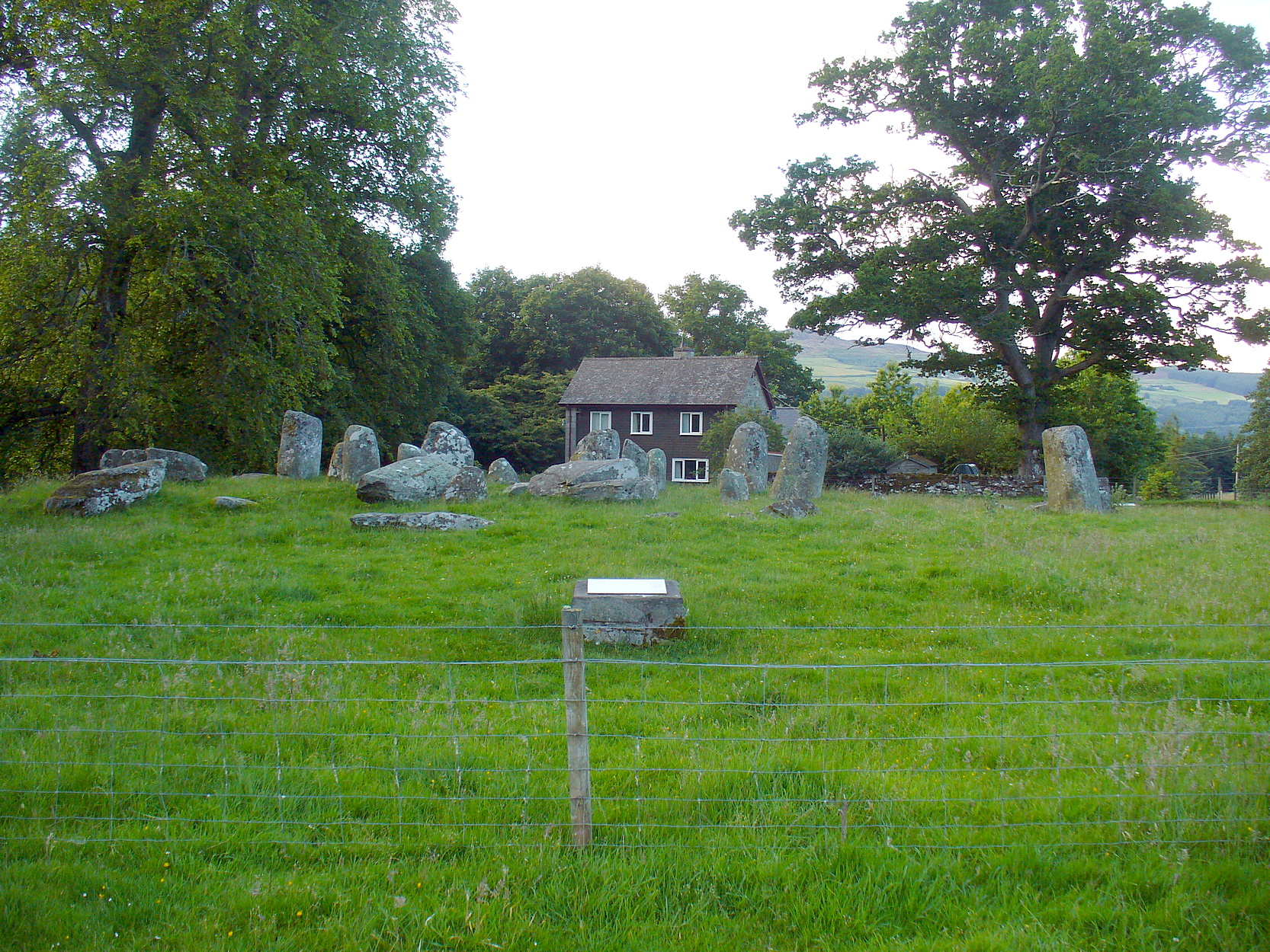
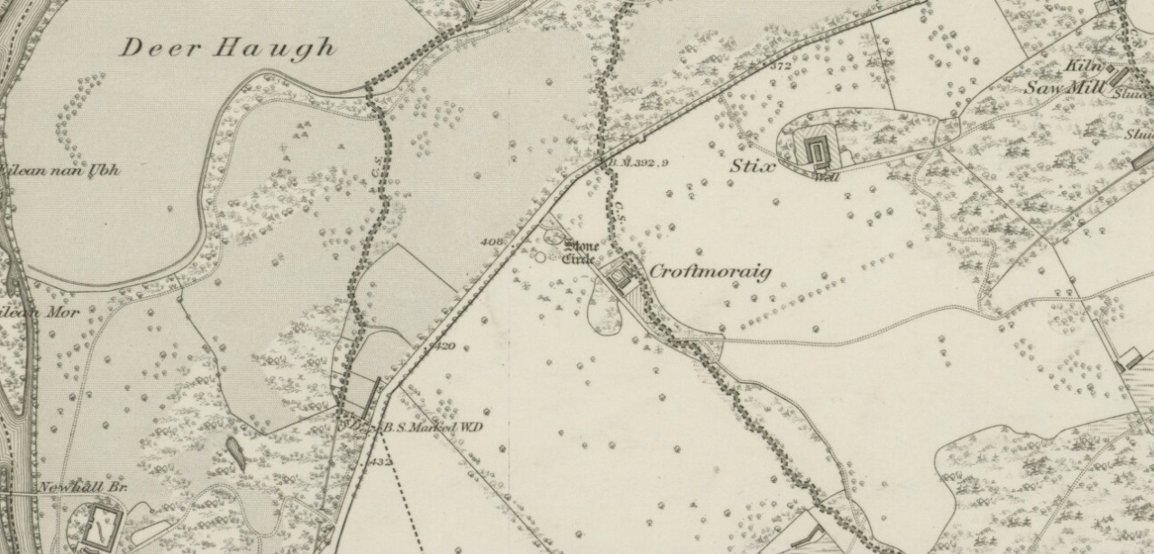
Take the A827 road that runs from Kenmore (top-end of Loch Tay) to Aberfeldy, and about 2 miles outside Kenmore, once you come out of the woodland (past the hidden standing stones of Newhall Bridge) and the fields begin on the east-side of the road, a small dirt-track leads you slightly uphill to the farm and house of Croftmoraig. The stone circle is right in front of the house less than 100 yards up the track (you can see it from the road).
Archaeology & History
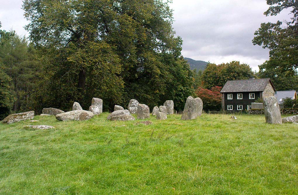
A truly fascinating site, whose history is much richer than its mere appearance suggests. It has mythic associations with both moon and sun, a cup-marked stone to the southwest, and an earlier structure that had Aubrey Burl (1979) suggesting was possibly “the dwelling-place of a priest, a witch-doctor, a shaman.” Not bad at all!
Croft Moraig on 1867 map
The sad thing today is its proximity to the increasingly noisy road to Aberfedly whose begoggled drivers care little for the spirit of place or stones. Here sits a feel of isolation and tranquility broken. But at least the cold information of its architecture is available for tourists and archaeologists alike; at least their depersonalized appreciations are served!
Described first of all (I think) in the old Statistical Account by Colin MacVean (1796), he told Croft Moraig to be one of “several druidical temples” in the area, “perhaps the largest and most entire of any in Scotland,” he thought:
“It is about 60 yards in circumference, and consists of three concentric circles. The stones in the outermost (ring) are not so large as those in the inner circles, and are not, like them, set on end.”
Hutcheson’s 1889 planCroft Moraig, looking N
The first decent archaeocentric evaluation of Croft Moraig was done in the 19th century by Alexander Hutcheson (1889), who gave us not only the first decent ground-plan of the site, but was also the first person to note that there were some faded cup-and-ring markings at the circle. After first directing his antiquarian readers to the site, he described the multiple rings of stones here, that had been built on top of an artificial platform of earth and stones:
“The circles are concentric, three in number, and occupy a little plateau which may be artificial, as the outer circle just covers it, on the gentle slope which here rises towards the south from the public road.
“I have prepared and exhibit a plan of the circles, and for reference have distinguished the stones by numbering them in the plan. The inner circle consists of eight stones all standing, with one exception, No. 3, which presumably has fallen inwards. The next or second circle consists of thirteen much larger stones, nine of which stand erect; Nos. 3 and 5 have presumably fallen in, while Nos. 7 and 9 have fallen outwards. The outer circle is formed by a number of smaller stones placed so as to form a sort of rampart. These are recumbent, and lie generally with their larger axes in the direction of the rampart. The circle measures, over the stones, as follows:
“Inner circle, West to East, 25 ft. 6 ins., North to South, 22 ft. 6 ins.
“Second circle, West to East, 40 ft North to South, 41ft 3in
“Outer circle, West to East, 58 ft North to South, 58ft
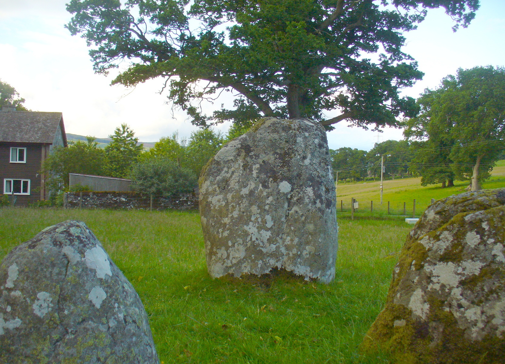
The stones are all rounded or water-worn boulders of dolerite, granite, schist, &c. The stones marked A and B are large blocks, 6 feet 6 inches high, 4 feet broad, and 2 feet 6 inches thick, standing upright. C seems to be a large (section) which has fallen from B, and lies flat on the ground.
“At the south-west side and in the line of the outer circle lies the cupmarked stone… If, as has been suggested, the two large blocks A and B formed the entrance to the circles, then the entrance faced towards the south-east. The blocks vary in height from 3 feet to 7 feet above ground, while of those which I have supposed to have fallen, their dimensions are, naturally from the ground-hold having to be added, much greater, amounting in one of them to 9 feet 6 inches long. There is a longish low mound of small stones, like an elongated cairn, which might yield something if it were to be searched. It lies just abreast of the cup-marked stone. I have referred to the recumbent stones in the two inner circles as having probably stood at one time erect. This I have presumed for several reasons, the principal being that one end of each of these stones corresponds in position with the circle formed by the standing stones; and while this is the case the recumbent stones do not preserve a uniformity of direction, but lie indifferently outwards and inwards from the lines of circularity, and at differing angles from these lines…”
Fred Coles’ site planOne of the cup-marked stones
Some twenty years later, the legendary northern antiquarian Fred Coles (1910) brought his lucidity to Croft Moraig and with it, even greater attention to detail. In a lengthy description of each and every aspect of the circle that has yet to be equalled he gave the reader the most detailed description we have. I hope you’ll forgive me adding Mr Coles’ prolonged description, but it is most valuable for anyone wanting to explore the site in greater detail. He wrote:
“As will be seen from the plan…the structural portion of Croft Morag consists, first, of a roughly circular, earthen mound (lettered in small type a-t), some 3 feet high, which is marked off by several stones of a more or less slab-like character, set irregularly upon a circumference of, approximately, 185 feet. This outermost setting, or revetment of stones is visible now only at certain fragments of the arcs; i.e., it is well-defined on the SW at a, where a long Stone, 6 feet 5 inches by 2 feet lies flat, and bears numerous cup-marks…; on the S arc there are five small Stones (b, c, d, e, f) all earthfast and flattish; on the SE are three similar Stones (g, h, i); on the E arc, four (j, k, l, m); on the N arc, very slightly to the west, one very large Stone (n) flush with the ground at the edge of the bank and a good deal overgrown with grass, measuring 8 feet 6 inches by 3 feet 3 inches; farther to the NW are five stones more (o, p, q, r, s), the last three having only very small portions visible; and, still farther round, is the last of what I consider to be these ridge-slabs (t) close under the edge of the great fallen sloping stone D. Thus the total number of measurable and separate stones now resting on the outermost ring is twenty.
“The stones of the intermediate ring constitute the imposing feature of the circle. They are thirteen in total number in the present condition of the circle, but they probably numbered eighteen when the circle was complete. Nine of them are the tallest in the whole group; four of these are prostrate on the W arc. By striking a radius from the common centre of the circle through the centres of these great stones which are erect, to the outermost circumference, the following measures are obtained: from centre of E, the NNW stone, to the ridge 14 feet 6 inches; from F, NNE stone to the ridge 13 feet 4 inches; from G to ridge 14 feet 4 inches; from H to ridge 13 feet 4 inches; and from I, the SE stone, only 10 feet 6 inches. The four fallen blocks, lying as shown A, B, C, D, no doubt stood on this intermediate ring, the diameter of which measured from centre to centre is 38 feet. Now, it must be observed that between A and B and A and I there are Stones (shaded in the plan); these two are erect, the one near B measuring 3 feet in length, 2 feet in breadth, and 3 feet 4 inches in height; it is quite vertical, and is undoubtedly in situ. The other small erect Stone midway between A and I has much the same size’ and features. Between B and C there is shown in outline another of these small stones ‘in line’ with the great pillars which remain on the E arc; and it is quite clear that if this remarkable and novel feature of alternating each tall stone with a very small but vertical block was originally carried out all round this intermediate ring, there would have been eighteen stones in all. Without the most arduous and careful excavation in these interspaces however, it would be extremely difficult, if not impossible, to prove that these small blocks did once stand on the eastern semicircle.
“As illustrating the general size of the great stones, when fully exposed to view, the dimensions of the four fallen blocks are here given: A, 7 feet 7 inches by 4 feet 10 inches, and fully 2 feet thick; B, 9 feet 2 inches by 3 feet 9 inches (on the upper face), and 2 feet 9 inches thick; C, 8 feet by 4 feet, and 3 feet fi inches thick; D, 7 feet by 4 feet 6 inches, and 3 feet thick at its vertical outer edge.
“The five upright stones of the intermediate ring measure as follows: I, the SE stone, 5 feet 6 inches in height, and in girth 11 feet; H, the east stone, 5 feet 8 inches in height, pyramidal in contour, and in girth 11 feet 4 inches; G, the NE stone, 5 feet 3 inches in height and 11 feet in girth; the next stone, F, 5 feet 7½ inches in height and 13 feet 6 inches in girth; and stone E, nearest to the north on the W arc, stands 6 feet 3 inches in height and measures round the base 9 feet 3 inches.
“The stones forming the inner ring, which is a broad oval in form, are eight in number, quite erect, with one exception; the fallen one (shown in outline) is due south of one set at the north point and the distance between these two is 23 feet 8 inches. If however, the distance between the N Stone and the E one at the SSE be taken, this diameter is 26 feet, as against one of 21 feet taken between the NW and SE stones. Measured from the centre of the fallen stone a space of 10 feet 3 inches divides that from the centre of the erect stone on the east, and an equal space divides it from the centre of the stone on the west. Between the N stone and that on its southwest an equal space of 11 feet 3 inches exists as between that stone and its SE stone; but between these last two there is a third almost exactly midway. The fallen stone measures 5 feet 10 inches by 3 feet 9 inches; the NW stone is 4 feet 6 inches in height, the SW stone 3 feet 6 inches, the N stone 3 feet 4 inches, the NE one 2 feet 6 inches, and the stone between it and the fallen block 3 feet 4 inches in height.
“In addition to the feature above noticed, of tall stones alternating with much smaller ones, Croft Morag possesses another noticeable arrangement in the presence of two great massive monoliths (U and V on the plan) standing like the remains of a portal, nearly eight feet outside of the boundary ridge on the SE. Neither of these stones is now absolutely vertical, stone U leaning considerably out towards the SE, and V having a very slight lean inwards to the circle. The former is 6 feet 2 inches in vertical height with a basal girth of nearly 12 feet, which is probably an under-estimate, for there are two large fragments (w and x) which appear to have been severed from this stone, the edges of which nearest the fragments are rough and sharp. The latter (V) stands 6 feet 4 inches in height and girths 11 feet 8 inches…
“…Besides its complexity of arrangement and the great number of measurable stones, forty-two in all, this circle is emphasised by the existence of a cup-marked stone set in a portion of its structure…on the SW arc… There are nineteen cups in all, only two of which differ much in diameter and depth from the rest, and there does not appear to be anything in their design to suggest a meaning or lend a clue to their symbolism.”
When the monument was excavated by Stuart Piggott and his mates in 1965, it was found to have been built over many centuries. As Aubrey Burl told:
“The first phase, of the late neolithic, consisted of about 14 heavy posts arranged in a horseshoe shape about 25ft 10in x 22ft 10in (7.9 x 7m) with a natural boulder at its centre. Burnt bone was found near this. Outside was a surrounding ditch and at the E was an entrance composed of 2 short rows of posts.
“In the second phase the timbers were replaced by 8 stones graded in height towards the SSW, also erected in a horseshoe 29ft 10 x 21ft (9.1 x 6.4m). A rubble bank was heaped up around it. On it at the SSW was a prostate stone with over 20 cupmarks carved on it. Other cupmarks were ground into the NE stone.
“Finally a circle of 12 stones, about 40ft (12.2m) is diameter, was erected around the megalithic horseshoe with a pair of stones forming an entrance at the ESE. Graves may have been dug at their bases later.”
Fred Coles mentioned a couple of other local names given to the site, one of which – Mary’s Croft – he thought may point “to a dedication to the Virgin.” Another curious place-name next to the site is called Styx,
“which appears to be the modern abbreviated form of the Gaelic word stuicnean. This, Mr Dugald McEwan affirms, meant ground full of overturned forest-trees; and it is therefore probable that in the remote past all the land surrounding the Stone Circle was a deep forest, and perhaps because of its seclusion, this site was selected as the most fitting for the erection of the principal Circle of the district.”
Alex Thom’s ground-plan
When the engineer and archaeoastronomer Alexander Thom (1967) came to examine Croft Moraig, he found the outlying stones to the southeast could have been solar alignment indicators, albeit poor ones. However, the geometric structure of the ring appeared to further confirm the use of his Megalithic Yard by those who built the circle. Thom’s illustration shows his finding, which he described briefly as follows:
“Two concentric circle and an ellipse. The circle diameters drawn are obviously too large and could be as small as 58.5ft outer circle and 41.0ft inner. Outer circle diameter58.5ft = 21.5 MY. Perimeter 67.5 MY = 27 MR. Inner circle diameter 41.0ft = 15.1 MY. Perimeter 47.3 MY = 18.9 MR. Ellipse drawn has major axis 11 MY, minor axis 8 MY, distance between foci is 7.5 MY. Perimeter is 30.0 MY = 12 MR. This ellipse looks slightly large but the triangle on which it is based and the perimeter are almost perfect.”
Folklore
Old lore told that the standing stones of Newhall Bridge 850 yards away (777m) were once connected with the Croft Moraig circle. William Gillies (1938) told this tradition saying,
“that at one time there was a paved way connecting the circle, of which these stones are the remains, with the great Croftmoraig circle.”
Croft Moraig, looking W
Fred Coles also noted that one of the stones in the circle (stone D in his plan) had “been polished by the sliding of generations of children”. This playful action on stones elsewhere in the UK and around the world sometimes relates to fertility rites (i.e., the spirit of the stone could imbue increased fertility upon the practitioner), but Coles made no mention of such rituals here.
References:
Burl, Aubrey, Rings of Stone, Frances Lincoln: London 1979.
Burl, Aubrey, The Stone Circles of Britain, Ireland and Brittany, Yale University Press 2000.
Follow the same directions for the Croft Moraig stone Circle. Then check out the elongated stone lying in the grass on the southern edge of the circle. It’s not that hard to find!
Archaeology & History
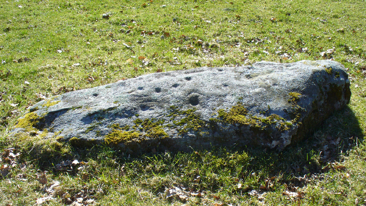
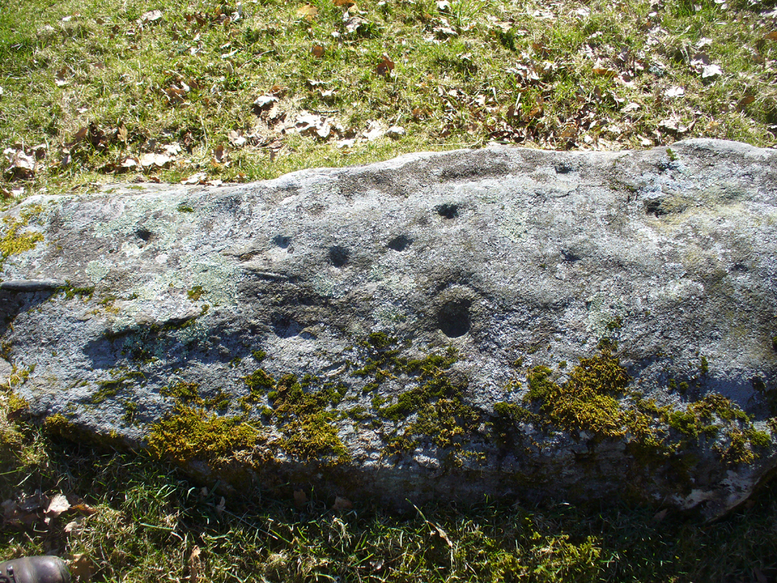
Nearly 13 yards (11.75m) south of the faded Croft Moraig 2 carving, this cup-and-ring stone on the SSW edge of Croft Moraig is one of at least four that have been found in this megalithic ring. It has been suggested that the stone on which the carving is found once stood upright. The earliest account I’ve found of it comes from Alex Hutcheson’s (1889) essay in which he wrote:
“At the south-west side and in the line of the outer circle lies the cupmarked stone. It is a recumbent stone, and like the others in that circle lies with its larger axis in the direction of the encircling line. It measures 6 feet 6 inches long by 2 feet broad, and bears on its surface 23 cups. Two of these are connected by straight channels. The largest cup is 2 inches in ‘diameter and f inch deep. Two of the cups are encircled, each with a concentric ring. None of the other stones exhibit any cups or other artificial markings.”
Cup-marks pointed outFred Coles 1910 drawing
…Although other cup-marks have subsequently been found on other stones within the circle. Consistent with the location of cup-and-ring marks elsewhere in the country, Hutcheson found the carved rock to be just in front of “a longish low mound of small stones, like an elongated cairn, which might yield something if it were to be searched.” Very little of this cairn remains today.
When Fred Coles (1910) came to explore Croft Moraig about 20 years later, he could only discern 19 cups on the stone, most of them the same size, “only two of which differ much in diameter and depth from the rest.” The cup-and-ring that Hutcheson described and the other missing cups had been overgrown by the grasses, Coles said. When Sonia Yellowlees described the carving in 2004, she said that 21 cups were visible, “one of which is surrounded by a single ring”—which you can clearly see in the photos below.
Carving 1 with cup-and-ringClose-up of design
When archaeologist Evan Hadingham (1974) looked at this site, he found deposits of quartz here and thought that their presence may have been relevant to the placement of the carving, noting how such a relationship is found at other circles in Scotland. In more recent years, rock art students Richard Bradley and others have found similar quartz deposits in or around some petroglyphs a few miles from here; as have fellow students Jones, Freedman and o’ Connor (2011) at some of the rock art around Kilmartin. In my own explorations of the carvings near Stag Cottage, hundreds of quartz chippings were found that had been pecked into the cups and rings.
References:
Burl, Aubrey, Rings of Stone, Frances Lincoln: London 1979.
The standing stone that could once be seen here is long gone. Its existence was reported in John Stuart’s (1854) short essay on stone circles of the region, in which he told:
“On the summit of the Hill of Balnoon, or rather on its neck towards the east, there was till lately a lofty upright stone called The Conwath or Conway Stone, and by some The Charter Stone. It was surrounded by a slight ditch.”
A recumbent stone in the field immediately north may relate to Stuart’s old report.
Folklore
In the same article, Mr Stuart told some interesting folklore which strongly implies the stone to have had importance for women. He said:
“It has been said that funerals coming from the west end of the parish were accompanied to this stone by the females of the family, and that the funeral here rested for a time, and the females returned (the stone being in sight of the churchyard). My informant (the minister of the parish) states, that a cairn on the hill of Auchinhamper was used for a similar purpose by funerals coming from the east end of the parish. On visiting the stone, however, I found that the churchyard was not visible from that spot.”
From Settle, take the same direction as if you’re visiting the giant Apronful of Stones cairn. Walk past it, keeping to the walling for 350 yards (319m) until you reach the gate on your right. Go through this and walk along the grassy footpath ahead of you for 75 yards (68.5m) and there, right by your left-hand side, you’ll see this low grassy circular embanked monument, or cairn circle.
Archaeology & History
This gorgeous, little-known cairn circle, hiding almost unseen beside the ancient grassy pathway that leads down to the haunted Borrins Wood, sits innocently, forgotten by those who would claim its importance. When this overgrown ring of stones was first built, the trees of Borrins Wood grew around the sacred court of this monument, watching rites committed to the ancestors, annually no doubt at the very least, under guidance of the Moon. But now such ways have been swept from the memory of those living, into worlds made-up of artifacts, linear time and dualist ideals, and our thoughts when brought here are encloaked by beliefs not worthy of such a place. Like many other small rings of stone, this was important for the rites of the dead. For here we can see a small stone-lined cist (grave) near the middle still growing from the Earth, with the small outer ring encircling the place of rites. It was obviously of ‘religious’ importance to those who lived here, probably even centuries after initial construction.
Embankment and central ‘grave’Central & southern section of the ring
Similar in size and structure to the Roms Law Circle on Burley Moor, this site on the hills above Giggleswick seems to be Bronze Age in nature. From outer-edge to outer-edge the rough circular monument measures approximately 14½ yards (13m) north-south, by 15½ yards (14m) east-west, with an outer circumference of about 49 yards (43m). The edges of the ring, as you can see in the photos, is made up of an embankment of thousands of small stones and rubble, measuring between 1-2 feet high and between 2-3 yards across. The old cist in the middle of the ring—about 1 yard by 2 yards—has been dug into at some time in the past and a small mound of stones surround this central grave. The entire monument is very much overgrown, but still appears to be in relatively good condition. A new excavation of this and nearby prehistoric monuments would prove worthwhile.
The ruined circle has a tranquil spirit, enclosed within a rich green panoramic landscape, enhanced with the breaking of old limestone and gnarled hawthorns. Other prehistoric cairns can be found nearby and the remains of a previously unrecorded prehistoric enclosure stands out on a small rise 164 yards (150m) southeast. We’ve found other unrecorded prehistoric remains in this arena which will be added to TNA, as and when…
References:
Speight, Harry, The Craven and Northwest Yorkshire Highlands, Elliott Stock: London 1892.


sm")
sm")
")


")