Danes Hills, Riccall, North Yorkshire

Tumuli:  OS Grid Reference – SE 645 377
Getting Here

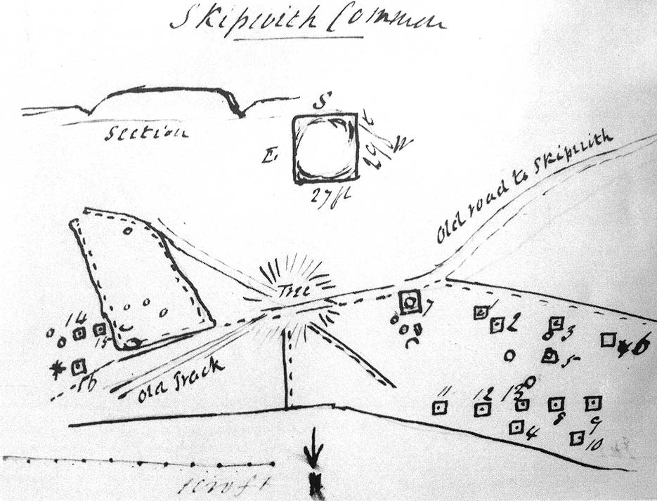
Sketch map of the Danes Hill tombs, 1849

Travelling up (north) the A19, just as you get to Riccal village, there’s a small road to your right: take this!  A mile along there’s a parking place just where the track veers into the woods.  That’s where you’re heading.  The remains of the tombs hereabouts can be hard to discern – but if your lucky you’ll either meet a local, or the virtue of patience will bring these overgrown tombs into focus!  There are other tumuli a few hundred yards east and north of here aswell.  If you wanna get a clear picture of them all, a full day would be a good bet!

Archaeology & History

Not to be confused with the other Danes Hills tombs a couple of miles northeast of here (as done on some other sites), the early Victorian geologist and explorer John Phillips (1853) was one of several early writers who described what, today, are known to be Iron Age tombs, scattered about a short distance east of Riccall village, saying:

“On Skipwith Common are many tumuli, old banks, and the slightly-marked foundations of ancient (turf or log?) houses or wigwams. These, by some error of tradition, are called ‘Danes’ Hills/ but, on opening the tumuli, no confirmation of so modern a date appeared. The tumuli are set in square fosses; the sides of the fossae range north and south and east and west (true). Similar facts appear in connexion with the tumuli on Thorganby Common adjacent. Burnt ashes and bones occur in the mounds; facts which suffice to overthrow the supposition of these hills being funeral heaps of the Danes of the llth century, for they then buried their dead. No instruments of metal, bone, or stone, or pottery were found.”

There were dozens of tombs that could be seen here in the past, but today many have been destroyed or are hidden by the cover of trees.  A sketch-map (above) showing the rough location of many of the graves was made by the Yorkshire Antiquarian Club after a visit here in 1849 (Proctor 1855), who opened several of the barrows.  Archaeologist Ian Stead (1961; 1979) defined these remains as being of the famous La Tene burials — though I’m unsure as to whether any of the tombs here had the great horse-chariots found in them, as found in the more famous Danes Graves tombs close to Driffield.

Folklore

The name of these small hills acquired their Danish title via a mix of real history and folklore.  History tells of the old Danish King Harald Hardrada, who moored his fleet of ships a few miles away from here before going into battle against the armies of Northumbria and Mercia. “Dane’s Hill,” said Bogg (c.1895), “still marks the spot where the fight took place.”  As John Burton (1758) told us:

“Ever since the aforesaid battle, it is by tradition to this day said, that the Danes were permitted to encamp here till they had buried their dead, and their ships at Riccal should be ready for their re-embarking for Norway.”

Local folk used to tell of the tradition of the local swamp — called Riccal Towdyke — being choked with the bodies of many slain in the battle hereabouts.  Many pieces of red cloth were found all around in the neighbourhood of these tombs.  However, despite this mix of fact and folklore, the tumuli were see marked on the modern OS-maps have been found to be Iron Age in origin.

…to be continued…

References:

  1. Bogg, Edmund, From Eden Vale to the Plains of York, James Miles: Leeds n.d.
  2. Burton, John, Monasticon Eboracense, N. Nickson: York 1758.
  3. Elgee, F. & H.W., The Archaeology of Yorkshire, Methuen: London 1933.
  4. Morrell, W. Wilberforce, The History and Antiquities of Selby, W.B. Bellerby: Selby 1867.
  5. Phillips, John, The Rivers, Mountains and Sea-Coast of Yorkshire, John Murray: London 1853.
  6. Proctor, W., ‘Report of the Proceedings of the Yorkshire Antiquarian Club, in the Excavation of Barrows from the Year 1849,’ in Proceedings of the Yorkshire Philosophical Society, 1855.
  7. Stead, I.M., ‘A Distinctive Form of La Tene Barrow in Eastern Yorkshire,’ in Antiquaries Journal, volume 41, 1961.
  8. Stead, I.M., The Arras Culture, Yorkshire Philosophical Society: York 1979.

© Paul Bennett, The Northern Antiquarian 

Barnhill, Jura, Argyll

Cairn:  OS Grid Reference – NR 7057 9700

Archaeology & History

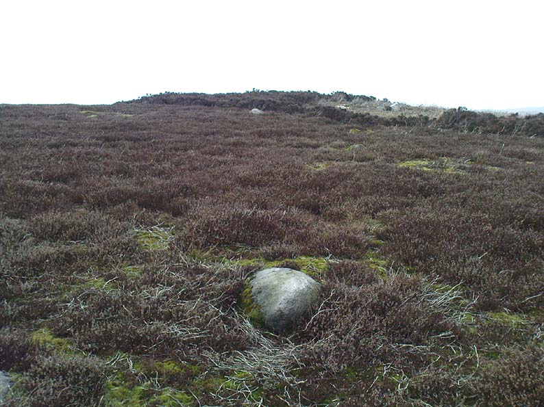
Very close to being at the top of the island.  If you do manage to get here take a gander at the legendary Gulf of Corryvreckan: one of the largest whirlpools on Earth, where the cailleach swirled her stuff when angry! This is the ‘hill where sorrel grows,’ and where George Orwell wrote 1984 – but more important for us is where the Royal Commission for Historic & Ancient Monuments of Scotland (Argyll, vol.5) designated that,

“a stony mound about 5.5m in diameter and 0.5m high, situated on the crest of the ridge east of Barnhill, appears to be a prehistoric burial cairn.”

Sadly I never managed to check this out when I was last up here as I didn’t know it was here!

References:

  1. Royal Commission on the Ancient & Historical Monuments of Scotland, Argyll: volume 5 – Islay, Jura, Colonsay and Oronsay, HMSO: Edinburgh 1984.

© Paul Bennett, The Northern Antiquarian


Cock Hill, Wadsworth Moor, West Yorkshire

Cist:  OS Grid Reference – SE 009 275

Also Known as:

  1. Mount Skip tomb

Getting Here

OK – OK – stop laughing at the title!  If you wanna check the hill out for yourselves, get to Hebden Bridge, then go up the long and very steep Birchcliffe Road.  Keep going all the way to the very top (a couple of miles uphill).  When you reach here, the building in front of you was the Mount Skip pub.  From here, walk up over the golf course and you’ll hit the disused quarries on the moor edge.

Archaeology & History

The grid reference given above is an approximation.  The tomb (long gone) was within 100 yards of the coordinate.  But don’t let that put you off having a good bimble around the moors here, cos there are several sites to see.

This long-lost burial was located in May, 1897, when quarrying operations were being undertaken behind the Mount Skip Inn, on the edge of Wadsworth Moor.  Ling Roth (1906) told that

“the first indications were the rolling down of pieces of urns which the delvers called flower pots.  Then in digging a hole to fix the leg of a crane, human bones were discovered.”

Geoffrey Watson (1952) later echoing Mr Roth’s comments wrote that,

“a grave containing a skeleton was discovered at a quarry about Mount Skip Inn.  The grave was about 6ft long, 14-18 in wide, and about 2ft deep.  The bones, which were exceedingly brittle, crumbled on handling.  Within the grave, and mainly at the ends, there appeared to be about 6 in of mixed charred wood and bones.  The larger portion of a small earthenware vessel was picked up and retained by one of the quarrymen.”

According to Mr Roth, the “earthware vessel picked up…by one of the quarrymen” was “picked up by a man named Thomas Greenwood, of Shawcroft Hill.”   What became of it, I do not know! If anyone knows, please let us know!

The description telling that “the grave was about 6ft long, 14-18 in wide, and about 2ft deep,” implies it to have been a stone cist – although this is quite long.  The nearest of any similar form would be the giant cairns at Low Bradley, 12½ miles (20km) to the north  This may have been the last remnants of a giant cairn (its landscape position would allow for this).

References:

  1. Roth, H. Ling, The Yorkshire Coiners…and Notes on Old and Prehistoric Haifax, F. King: Halifax 1906.
  2. Watson, Geoffrey G., Early Man in the Halifax District, Halifax Scientific Society 1952.

© Paul Bennett, The Northern Antiquarian


Mini-Skirtful of Stones, Ilkley Moor, West Yorkshire

Cairn:  OS Grid Reference – SE 1346 4606

Getting Here

Follow directions to get to the Pancake Stone.  From here walk SE on the footpath that runs on the edge of the moor.  After about 200 yards you’ll hit a small footpath which heads into the moor (south).  Walk on here for about 200 yards and notice the small rise in the land to your right (if you cross the small stream where the land dips into a very small valley, you’ve gone past).  That’s it!  The Little Haystack Rock is less than 100 yards away down the slope from here.

Mini-Skirtful of Stones, looking north

Archaeology & History

Of approximately eighty prehistoric cairns that have been alleged to exist along the Green Crag Slack ridge on Ilkley Moor, this site in particular is worthy of note, due mainly to its size. As independent archaeological researcher Paul Bowers said of it when he first saw this cairn-spoil, “it seemed too big to have not been discovered in the past.”  Too right!

Mini-Skirtful, looking west

When we tracked across Green Crag Plain a few days ago, it was Michala Potts that called our attention to it.  Half-covered in full heather growth, only the eastern edge was exposed.  At first it seemed that it was loose prehistoric walling, but then I realised it was on the edge of small knoll and the stone work was deeper and wider than walling.  As we explored through the heather atop of the knoll, it was obvious that there was a more extensive gathering of stones scattered all over the top of this small rise, and it seemed that we were looking at the remains of a reasonable sized cairn. Its extent carries about ten yards down the slope from the small hillock, but only a few yards either side of it.  It seems likely that the extended loose stones have, over the centuries, simply slipped further down the slope.  However, not until a decent excavation occurs will we know anything certain.  It is possibile that this is simply the scattered remains of damaged neolithic or Bronze Age walling, but only a more detailed exploration of the site will tell us for sure.

Cowling (1946) mentioned the numerous cairns and scattered walling reaching across this part of Ilkley Moor, but gave no specific information relating to this mini-skirt full of stones! (blame Mikki for the title!)

References:

  1. Cowling, E.T., Rombald’s Way, William Walker: Otley 1946.

© Paul Bennett, The Northern Antiquarian


Cat Heaps, Swanston, Edinburgh, Midlothian

Cairns (destroyed):  OS Grid Reference – NT 2447 6828

Archaeology & History

Not far from the giant cup-marked Caiy Stone, there used to be two very large prehistoric cairns, which local historian Daviid Shankie told us “were foolishly broken up by some sacriligious hand and used for road metal”!  Not good…  Remains of human bones and several fragments of old weapons were found in them.  Fred Coles (1903) told us that:

“In the neighbourhood of this [i.e. Morton Hall], but further southwest, on the grounds of Comiston, were found, in forming the public road, under large heaps of stones, various sepulchral stone enclosures, in which were deposited urns with dead men’s ashes, and divers warlike weapons.” And again, when speaking of the levelling of a part of the ground close to the old (so-called Roman) road, by Sir John Clerk of Pennycuick, the same writer adds, there ” were discovered several stone coffins with human bones.”

Folklore

According to Shankie (1902), these two great cairns were built upon lands previously known as the Templelands of Swanston and commemorated a great battle that was fought “between the ancient Picts and Scots.”

References:

  1. Coles, Fred, ‘Notice of…Cairns and Standing Stones in Midlothian and Fife,’ in PSAS 37, 1903.
  2. Harris, Stuart, The Place-Names of Edinburgh, Gordon Wright: Edinburgh 1996.
  3. Royal Commission for the Ancient & Historical Monuments of Scotland, Midlothian and West Lothian, HMSO: Edinburgh 1929.
  4. Shankie, David, The Parish of Colinton, John Wilson: Edinburgh 1902.

© Paul Bennett, The Northern Antiquarian


Harlaw, Fairnington, Roxburghshire

Stone Circle (destroyed):  OS Grid Reference – NT 666 286

Archaeology & History

One of those site place-names with a familiar ring to it: Har, boundary; law, tumulus (though it can also be used to mean ‘a meeting place’).  Nevertheless, whatever the precise origin of the name, the site here seems to have been destroyed.

Although listed by the Royal Commission in 1956 as a stone circle, John Barnatt thinks it may have been a tomb of sorts – which is what the place-name infers if we’re puritanical about it.  Alexander Jeffrey (1864) told us the most, saying that:

“A field to the east of Fairnington village is called Harlaw, from a circle of large stones which stood within it, but which have been removed to serve farm purposes.”

Its exact location is unknown, though the Royal Commission lads thought it probably “stood somewhere near the present Harelaw Plantation,” about a mile east of the village.  Any more info on this lost site would be most welcome!

References:

  1. Burl, Aubrey, The Stone Circles of Britain, Ireland and Brittany, Yale University Press 2000.
  2. Gelling, Margaret, Place-Names in the Landscape, Phoenix: London 2000.
  3. Jeffrey, Alexander, The History and Antiquities of Roxburghshire – volume 3, Seton & MacKenzie: Edinburgh 1864.
  4. Royal Commission on the Ancient & Historical Monuments of Scotland, Roxburghshire – volume 2, HMSO: Edinburgh 1956.

© Paul Bennett, The Northern Antiquarian 


Haulgh, Bolton, Lancashire

Tumulus (destroyed):  OS Grid Reference – SD 7242 0899

Archaeology & History

This single-grave burial — described by Barnes (1982) as a kerbed or revetted cairn — close to the very centre of modern-day Bolton, was once an impressive prehistoric tomb.  It was described by a local historian, Matthew Dawes, amidst a variety of prehistoric remains in and around Bolton, most of which have long-since been forgotten.

“Near Haulgh, about a quarter of a mile south-east from Bolton Parish Church, on a piece of high flat land, on the east bank of the Croal, and about fifty feet above the river, was a tumulus, about thirty feet in diameter, and four feet deep, consisting of small boulders… It was discovered in September, 1826, in forming a branch of the new road leading from Bolton to Bury. It was probably much depressed in its formation and was covered with a few inches of mound. The cop or fence crossed it in a north and south direction. About the centre of this tumulus was a cist-vaen, about four feet six inches long and one foot deep, formed of four upright stones and a coverer, and its length was nearly north and south. In this cist-vaen was a skeleton, with the legs doubled up, and the head to the north. Near the head, and on the west side, was found an urn, inverted, four and a half inches in the widest diameter, and three and a quarter inches high, and perforated by four small holes in the widest part. On the other side of the head was a bronze spear-head, four and three-eighths inches long, and one and three-eighths inch wide, of which the point was bent back, and a piece of the side chipped away. The urn and spear-head were taken to the Countess of Bradford, the Earl of Bradford being the owner of the land.”

Intriguingly, if you’re from the Bolton region, Mr Dawes also told that, “A man in the employ of the Earl of Bradford, the superintendent of the work, who made the discovery, informs me (1862) that two other tumuli were found shortly after the one just described, a few yards to the south of it, in the same fence.”  As yet I have no more information about these other tombs (gimme time though!)

References:

  1. Barnes, Bernard, Man and the Changing Landscape, Unversity of Liverpool 1982.
  2. Dawes, M., ‘British Burial Places near Bolton,’ in Trans. Hist. Soc. Lancs & Cheshire, volume 4, 1852.
  3. Scholes, James C., History of Bolton, Daily Chronicle: Bolton 1892.

© Paul Bennett, The Northern Antiquarian


Old Woman’s Well, Guisborough, North Yorkshire

Holy Well (lost): OS Grid Reference – NZ 610 180

Getting Here

The grid reference here is an approximation, but the old well was definitely somewhere very close by, as evidenced by the place-name of the farmhouse. But if you wanna get here and wander about in the hope that you can re-locate this once sacred water source, go up the B1269 road north of Guisborough for about a mile. Carling Howe farmhouse is on the left-hand side of the road. Obviously the old well is somewhere close by…

Archaeology & History

The information I have of this site comes from old place-name listings. I found the reference in the directory for North Yorkshire by A.H. Smith (1928), in his entry for the etymology of ‘Carling Howe’ at Guisborough.  Smith ascribes the references of ‘Kerlinghou’ (which itself appears to have been lost) to mean the ‘Old woman’s mound’ and variants thereof, also saying, “There is an unidentified place in this township called Kerlingkelde,” (12th century ref. Guisborough Cartulary)—the ‘Old Woman’s Well’.  Very commonly in this part of Yorkshire—as at many other locations in northern England—a hou or howe (and variants thereof) relates to a prehistoric tomb – which is probably what we had here: a prehistoric Old Woman’s Grave with an associated Old Woman’s Well in close attendance.

The ‘old woman’ element in this name very probably relates to that primal mythic deity, the cailleach, the great prima mater of indigenous heathen folk, beloved mainly in Scottish and Irish lore, where her copious name and tales resonate to this day. This “well of the Old Woman, or cailleach“, would have been a place of particular importance in the mythic cosmology of our ancestors, but its precise whereabouts seems forgotten. There is a plentiful supply of water around Carling Howe Farm, one or more of which may once have been the site of this well. However, a lot of quarrying operations occurred here in the not-too-distant past, and this may have irreparably damaged our ability to accurately find the site – though perhaps a perusal of old field-maps could be productive.

It would also be good if we could locate the original whereabouts of the old tomb here which gave the place its name – the ‘Carling Howe’.  Other ‘howe’ sites in East and North Yorkshire turn out to be prehistoric burials and I have little doubt that the same occurred here.

References:

  1. o’ Crualaoich, Gearoid, The Book of the Cailleach, Cork University Press 2003.
  2. Smith, A.H., The Place-Names of the North Riding of Yorkshire, Cambridge University Press 1928.

© Paul Bennett, The Northern Antiquarian


Blackhill, Hazelbank, Lanarkshire

Standing Stone (destroyed): OS Grid Reference – NS 829 442

Archaeology & History

No longer here, but about 200 yards north of the old farmhouse of Blackhill (with its ancient tumulus still in attendance across the road) could once be seen a decent standing stone, “fully six feet high.” It seems that this was sadly uprooted sometime before 1954.

References:

  1. Royal Commission on the Ancient & Historical Monuments of Scotland, Lanarkshire: An Inventory of the Prehistoric and Roman Monuments, HMSO: Edinburgh 1978.

© Paul BennettThe Northern Antiquarian


Scale House, Rylstone, North Yorkshire

Tumulus:  OS Grid Reference – SD 97088 56870

Getting Here

Pretty simple really.  Go up the B6265 Skipton-Rylstone road for about 3 miles, past the Nettlehole Ridge woodland on your right.  The next turn along to your right, up the track, is Scale House.  Go past this until you get to Scale House Farm.  The remains of the burial mound is in the field to your left, just before the farm.  Knock on the door and ask!

Archaeology & History

This ‘tumulus’ (as it’s marked on the OS-map) was one of the many explored by the legendary reverend William Greenwell (1864) in the middle to latter-half of the 19th century.  His description of the finds at Scale House were considerable; thankfully our old Yorkshire antiquarian Edmund Bogg (1904) shortened it and told us the following:

“The tumulus was 31 feet in diameter and about 7 feet high; it opened from the southeast; the soil immediately under the sod consisting of yellow clay to a considerable depth; then layers of blue clay… Exactly in the centre…at a depth of 7 feet, and on a level with the plane of the field, was found an oak coffin, formed out of a tree, split and hollowed-out, and placed due north and south, the head being placed to the south, as that as the larger part of the tree. After being exposed to the air for about 2 minutes, the bared coffin parted at the sides, and could not be moved except by detached pieces. The body had been wrapped in a cloth or shroud of texture resembling wool and coarsely-woven, of which there was a considerable quantity remaining; but the body itself was dissolved… The interment was considered to be that of an ancient Briton… The learned antiquary said it was the only instance (except the one at Gristhorpe, near Scarborough) where an interment in an oak tree hollowed out had a tumulus placed over it. It was more than 6 feet in length inside and about 7 feet 6 inches outside. The remains were carefully replaced and the mound restored to its former shape; a small leaden tablet being placed within, stating that it had been opened in AD 1864.”

Folklore

Jessica Lofthouse (1976) listed this as one of the places reputed to be an old fairy haunt, wherein “the folk of Scale House discovered a fairy kist or chest.”

References:

  1. Bogg, Edmund, Higher Wharfeland, James Miles: Leeds 1904.
  2. Greenwell, William, British Barrows, Clarendon Press: Oxford 1877.
  3. Lofthouse, Jessica, North Country Folklore, Hale: London 1976.

Links:

  1. Out of Oblivion: Archaeology and Notes – Directions and notices on this once giant tomb.

© Paul Bennett, The Northern Antiquarian