Park up at the Nick of Pendle and follow directions to the Devil’s Apronful of Stones, but about halfway along the path, bear to the right along a swerving footpath which eventually takes you to another guiding cairn. On the OS-maps there’s the Chartist’s Well 100 yards due west of this old overgrown tomb.
Archaeology & History
The much-overgrown Lower Apronful cairn
Seemingly excluded from all previous archaeological surveys, this is a very large structure indeed. Crowned with a small modern cairn on its top marking a small footpath crossing the site, this very large cairn-like structure is about four feet tall at the highest. I first came across it at the end of August, 2006, after going through some folklore records which then led to exploring the area in the hope that there might be some archaeological ruins in the region — and we weren’t to be disappointed!
Outline of extended monument
This giant cairn structure is larger than the denuded remains of the Devil’s Apronful cairn that can be seen a few hundred yards further uphill, but is almost entirely overgrown with grasses. It measures at least 31 yards (east-west) by 29 yards (north-south) and is just like an overgrown Little Skirtful of Stones on Burley Moor. Parts of its eastern side have been dislodged and the main rock structure is plainly visible where the vegetation has come away. A ringed embankment is also very clear, mainly on the north and eastern sides of this large structure (as one of the photos here shows), but on the whole it is overgrown and ruinous. It’s a brilliant spot though and sorely needs some proper archaeological attention. In the event that this site aint a prehistoric cairn, please lemme know so I can delete it from TNA.
Follow the same directions for getting to the Black Hill Round Cairn. It’s less than 100 yards away – you can’t miss it!
Archaeology & History
This is a superb archaeological site — and it’s bloody huge! It’s big and it’s long and it sticks out a bit – which is pretty unique in this part of the Pennines, as most other giant cairns tend to be of the large round variety. Although the site was originally defined by Arthur Raistrick (1931) as a long barrow, J.J. Keighley (1981) told how, “it was found to be a round cairn imposed on a long cairn.” And it’s an old one aswell…
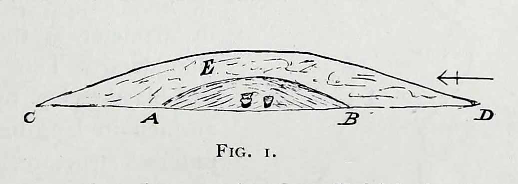
Near the SE end of the giant cairnClose-up of the main cist
More than 220 feet long and 80 feet in diameter at its widest southeastern end, as we walk along the length of the cairn to its northwestern edge, its main body averages (only!) 45 feet in diameter. Made up of tens of thousands of rocks and reported by Butterfield (1939) to have had an upright stone along its major axis, the “height varies from 4-8ft, but the cairn has been much despoiled and disturbed,” said Cowling in 1946. He also told how,
“Excavation revealed that almost in the centre of the mound were the remains of a cist made of roughly dressed stone flags and dry walling, covered by a large stone. Under a stone slab, laid on the floor of the cist, were fragments of (burnt and unburnt) bone and a small flint chipping.”
This is a very impressive site and deserving of more modern analysis. The alignment of the tomb, SE-NW, was of obvious importance to the builders, believed to be late-neolithic in character. The tomb aligns to two large hills in the far distance in the Forest of Bowland which we were unable to identity for certain. If anyone knows their names, please let us know!
Folklore
The older folk of Bradley village below here, tell of the danger of disturbing this old tomb. In a tale well-known to folklorists, it was said that when the first people went up to open this tomb for the very first time, it was a lovely day. But despite being warned, as the archaeologists began their dig, a great storm of thunder, lightning and hailstones erupted from a previously peaceful sky and disturbed them that much that they took off and left the old tomb alone. (I must check this up in the archaeo-records to see if owt’s mentioned about it.)
References:
Ashbee, Paul, The Earthen Long Barrow in Britain, Geo Books: Norwick 1984.
Butterfield, A., ‘Structural Details of a Long Barrow on Black Hill, Bradley Moor,’ in YAJ 34, 1939.
Cowling, E.T., Rombald’s Way, William Walker: Otley 1946.
Keighley, J.J., ‘The Prehistoric Period,’ in Faull & Moorhouse’s West Yorkshire: An Archaeological Survey, I, WYMCC: Wakefield 1981.
Raistrick, Arthur, ‘Prehistoric Burials at Waddington and Bradley,’ in YAJ 30, 1931.
The faded remains of this old burial mound can vaguely be seen just off the right-hand (east) side of the B1248, across the road from the track which leads down to Burdale North Wold farmhouse, between Fimber and Wharram-le-Street.
Archaeology & History
Known as Towthorpe Barrow No.1 in the Mortimer survey (1905), there are a number of prehistoric tombs and other remains close to this site (which will be described on TNA as time goes by). Some of you might think the lengthy description here a little unworthy, but I believe the extensive archaeological notes on this site by an archaeological legend, J.R. Mortimer, is a good indicator of the dedication and interest to which he gave each and every tomb that he opened (this’ll be the first of many). His slightly edited account told:
“This mound is situated near the centre of the (Towthorpe) group, close to High Towthorpe. Here the green lane…is crossed by the high road from Malton (B1248), through Wharram-le-Street… Part of this road, for some distance south and north of the barrow, is called ‘High Street’ by the old inhabitants of the neighbourhood…
“On 4 May, 1863, the writer, with the assistance of R. Mortimer and two workmen, commenced to open this mound. It was the first British barrow he had the pleasure of examining. A trench 10 feet wide was cut across its centre from the northern to the southern margin…
“The upper portion E, to a depth of 16 inches, consisted chiefly of the surface soil of the neighbourhood, the bottom part of which was reddened as if by the action of fire. Close below this was a stratum of wood and ashes and other dark matter, 2-3 inches in thickness; and then a lenticular bed of tough drab-coloured clay, 29 feet in diameter, and 12-14 inches thick in the centre, gradually thinning towards the circumference. The upper part of this bed of clay, which was in contact with the stratum of wood ashes, was reddened by fire; its under surface had a similar appearance and rested upon what seemed to be a second stratum of burnt and decayed matter, 2-3 inches in thickness, similar to that already described. The clay forming this lenticular bed contained numerous small fragments of grey flint, characteristic of the chalk of the neighbourhood. It must have been obtained from one of the valley bottoms (either Burdale, Wharram-le-Street or Duggleby), in which are exposures of the Kimeridge clay. In these places, angular pieces of flint and chalk crumble from the hillside, and mix with the clay, imparting a greyish colour to it. This is especially the case at Burdale, where there is a fine spring at the base of the chalk, and a small pond resting on the Kimeridge; and it is probably from this place that most of the clay for the construction of this barrow was obtained. It is not easy to explain the method by which the clay was transported, but several tons had evidently been used in this case. Many other instances in which material from a distance has been used in the erection of the barrows of this neighbourhood are recorded in (the Yorkshire Wolds).
“In the centre of the mound, at the base of the lenticular bed of clay and below the ashes (which probably represent the residue of a funeral pyre) stood two food vases, close together, and near to these, decayed bones (the remains of a human body) and a chipped flint. The smaller and more ornamented vase was situated to the south of its fellow. It measures 4.5 inches in neight, 5.5. inches in diameter at the top, and about the same across the shoulders. The ornamentation had been impressed on the plastic clay by a thin square-ended tool, about half-an-inch in length, which showed in the impression of a fine notched structure, and was equally divided into ten ridges about the size of the indentations on the milled edge of a shilling, and almost as truly cut. In the lower groove which runs round the vase are four pierced projections.
“The other vase is about 5 inches high and about 6 inches in diameter at the top and across the shoulders. Three encircling lines of short vertical cuts, rudely and apparently hastily made, previous to baking the vase, represent its entire ornamentation.
“During the excavation we collected from the material of the mound a dozen hand-struck flint flakes of various sizes, and a small splinter from the cutting-edge of a green-stone celt.”
Mr Mortimer returned to do further excavations here on Christmas Eve and Christmas Day in 1865, with the hope of finding more — but apart from a finely-cut knife made of black flint, nothing else was located. This was the first of Mortimer’s hundreds of diggings into the tombs and dykes of East and North Yorkshire.
References:
Marsden, Barry M., The Early Barrow Diggers, Tempus: Stroud 1999.
Mortimer, J.R., Forty Years Researches in British and Saxon Burial Mounds of East Yorkshire, A. Brown: London 1905.
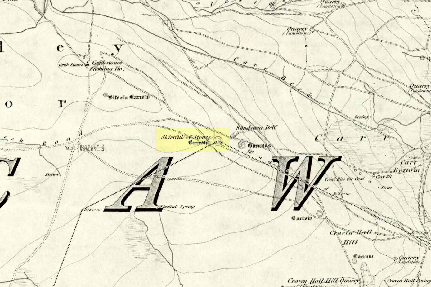
Follow the directions to reach the Great Skirtful of Stones giant cairn (very worryingly being encroached upon, illegally [it’s a protected monument], by employees of Bradford Council digging tracks into its edges). Walk less than 100 yards to the east, down the slight moorland slope (Leeds & Otley Chevin are in the distance). You’re here!
Archaeology & History
This is a very intriguing site. Intriguing because we don’t actually know what it is! It’s best seen at the end of winter, shortly after the heather-burning’s been done; but if there’s been no burning here, after a year or two it’s almost impossible to find!
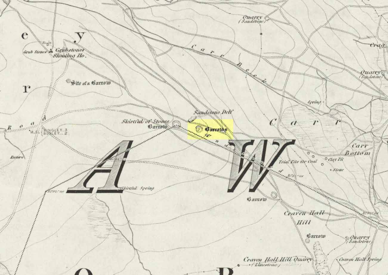
Great Skirtful Ring on 1851 mapColls’ 1846 plan
Despite it being only a short distance east of the Great Skirtful giant cairn, very little has been written about it (a surprise in itself!) – but this is down the failings of archaeological professionals in the area, who still neglect this incredible prehistoric arean. It was first described in Mr J.N.M. Colls’ (1846) survey of sites in the region, where he thought it to be a prehistoric camp. Several years later the Ordnance Survey lads visited here and deemed it to be prehistoric barrows, which doesn’t seem true. Nearly a hundred years later, the great northern antiquarian Eric Cowling (1946) who saw fit to describe it as an “enclosure” — so I’m copying his idea so I don’t get into too much trouble! Thinking it to be a Bronze Age monument, he wrote:
“On the main ridge of Rombald’s Moor and about eighty yards to the east of the Great Skirtful barrow, is a small circular enclosure with a diameter of twenty yards. There appears to have been an entrance on the eastern side, which is protected by a short length of banking to the east.”
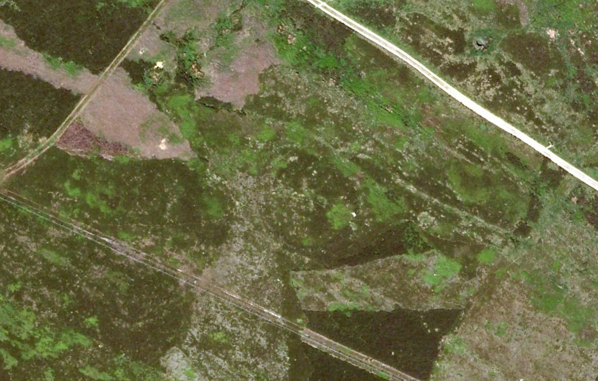
Aerial image, 2002Aerial image, 2009
The “length of banking” he described didn’t seem apparent when we visited the site yesterday (23.3.09), but we intend a further exploration of this and the adjacent monuments in the coming weeks and hope to locate it!
Interestingly, the archaeologists Faull & Moorhouse (1981:1:103), in their otherwise fine survey, actually doubted this place as having any prehistoric status, without giving any reason why—which was a big mistake. No doubt they spent too much time in offices and board meetings instead of getting out a bit more! Unless evidence to the contrary can be strongly presented, this site must be classed as undoubtedly prehistoric in nature (Bronze Age or Iron Age certainly) and almost certainly had something to do with rituals of the dead.
Great Skirtful Ring embankmentSouthern edge of the ring
From outer edge to outer edge the ‘ring’ measures 102 feet across, N-S, and with a rough maximum 101 feet E-W, being diameter, being some 300 feet in circumference. When you look at the site at ground level it appears to be an almost perfect ring, consisting of an embankment little more than 2 feet high at the most, with entrances both east and west. However, as the aerial images show, the perfect circle aint quite so perfect! But at ground level, there’s a certain uniformity about it. The embankment is in very good condition around much of the ring, with only slight damage in certain parts. The western opening strongly implies a direct relationship with the Great Skirtful cairn — which would infer this monument to have more of a ritual nature rather than the simple domestic enclosure, inferred by Colls and Cowling. Adding to this we find a tumulus 100 yards east and the remains of several other cairns nearby, making the site almost hemmed in by death-sites. A prehistoric cemetery is a short distance further down the moorland slopes to the east. Add also the fact that the Burley Moor stone avenue runs immediately south and the death-motif has to be increased.
What do I think it is? Not sure! The thought that it’s a previously unrecognized henge has crossed my mind…but henge monuments aren’t things that I’m very clued-up on, so wouldn’t like to say for sure. If there are any university archaeology students out there who are into getting their feet dirty, give this site a look-over. It’s intriguing, in very good condition, and could do with an accurate ID!
References:
Bennett, Paul, The Old Stones of Elmet, Capall Bann: Chieveley 2001.
Colls, J.N.M., ‘Letter upon some Early Remains Discovered in Yorkshire,’ in Archaeologia, volume 31, 1846.
Cowling, Eric T., Rombald’s Way, William Walker: Otley 1946.
Faull, M.L. & Moorhouse, S.A. (eds), West Yorkshire: An Archaeological Survey – volume 1, WYMCC: Wakefield 1981.
Although I describe this site in association with the township of Kilmartin, it is in fact several miles north of there – but I reckoned that if I say it’s near Kilmartin, then those of you who don’t really know this region, will have some idea of its locale. So – from Lochgilphead, go up north thru Kilmartin, another coupla miles on, till you reach the small road to your right (signposted ‘Ford’). Just keep driving for a couple more miles until you hit the village. If you park by the only shop, you’re just past the old tomb. Diagonally across on the opposite side of the road from the Ford Hotel, right by the road-junction, just before the little shop, you’ll see a notable rounded mound overgrown in shrubs. Embedded in this are the remains of an old tomb.
Archaeology & History
Ford tumulus (photo, couresty J. Reid)
This typical-looking fairy-mound just by the road junction in the village is where me and my daughter used to scramble around, sometimes playing and sometimes seeing if we could find anything of note in this ancient hillock, but all trace of any prehistoric stonework seems to be well-buried. When excavators explored the site in bygone times, a small stone cist was found, which aligned (yet again) north-south and measured internally, roughly, 3ft x 2ft. Only small!
A food vessel in Edinburgh’s central museum, “found in a cist in the neighbourhood of the lower end of Loch Awe” is thought to have come from this tomb.
References:
Royal Commission on the Ancient & Historical Monuments of Scotland, Argyll – volume 6: Mid-Argyll and Cowal, HMSO 1988.
Best approached by taking the same direction to the unexcavated Foster Clough ‘enclosure.’ From here, walk towards the walling about 100 yards to your east. Follow it along on the moorside for another 100 yards then follow the small sheep-path up the angle of the slope onto the moor itself. Once you’re at the top and on the level, it’s right ahead of you! If the heather’s deep though, you might as well give up before y’ start! (honest – I went there a while back for a night’s sleep & couldn’t find the damn thing!) But if you’ve made the effort getting here, wander 200 yards towards Crow Hill and keep yer eye out for the large heather-clad tumulus.
Archaeology & History
This site was rediscovered in October 1995, when I was bimbling about on the southern side of Crow Hill. It was one of those good periods, when the heather had been extensively burnt back, so enabling a better examination of the moors for any potential prehistoric remains. I unknowingly walked right into the middle of this small ring of stones with a fella called John Billingsley, who seemed quite unaware of what I was getting excited about until I pointed out to him exactly what we were standing in the middle of! (he couldn’t see what was under his nose, which was a bit weird considering he edits an earth-mystery mag) But I wouldn’t have even been looking for this site, were it not for what happened just a few days earlier…
I was on one of my many ambles across the moortops, which to many people watching would seem like some seemingly aimless, lost soul – an apt description at times! – wandering across the hills (those who know me well, have long called such seemingly aimless treks, Barmy Bennett Expeditions!). It was a lovely day: a shallow snow-cover lay across the moors and as the wind brushed across the earth and up, Her wisps of breath were freezing. But I was well-wrapped and sat, upon occasion, behind the small rock outcrops I was checking for cup-and-rings for shelter when needed. But as the day fell on and the sun touched the western hills, I had to turn for home as the cold was strengthening. Being on the moors at night, in this sort of weather, is never a good idea unless you’ve got your gear with you — and this day I hadn’t. So I set off back for home in Hebden Bridge, in that dreamy sort of state which the hills elicit after a day’s ambling. The colours of Earth and Sky were crisp in the bracing air and as I headed for the footpath towards the old stone known as Churn Milk Joan, I gazed at Crow Hill a half-mile or so away…
Without warning, it came like a thunderbolt up through my dreaming mind: ‘There’s a stone circle over there!‘ came the words. And though the words were quiet and simple, their effect was anything but! I focused quickly – very quickly! My mind staggered out of the dreaming and into the ego state, trying quick to rationalise what had just emerged from my unconscious. An adrenalin rush hit me and amidst the snow-filled hills I started to bound, gazelle-like, across the wibbling moors, straight towards Crow Hill. But then I stopped!
“Wait… She’s nearly dark,” I said to myself. “You’ve no food and there’s gonna be no no light. Come back in a day or two and you’ll have all the time you need to explore.”
And so I wandered back in the dark to the warmth of fire and home and waited a few days, for the Earth to drink Her snow, and hope that the curious intuition — as it had been on numerous other occasions — proved fruitful. And so it did…
If you can find the place (almost impossible when the heather’s in full growth), you’ll see that this ‘cairn circle’ is little more than 32 feet across, with the tallest stone in the ring little more than 2 feet tall. A curious small squared circle of loose stones exists in the south side of the ring and a raised embankment surrounds the site. Scatterings of small, football-sized stones are found both in, out and at the edge of the circle. (Please note – to those of you who wanna cross-reference – that the photos alleging to show this site on The Megalithic Portal are not of the right place.)
Close by are other neolithic remains, including extensive walling, 2 or 3 other small standing stones and a large tumulus which one rather myopic hobbyist (Mike Haigh) reckoned – in a poor attempt at sarcasm – might be the burial tomb of a successful local farmer. Hmmmm…..
The site was later described in an article by the same Mike Haigh (in Billingsley’s Aspects of Calderdale) as being discovered by John Billingsley himself, which wasn’t just a mistake but a rather huge lie. John was there with me when I found it, as he knows full well. But it seems here we have an example of people who like to try give themselves credit for discovering things that they did not do.* Even sillier, Mr Billingsley then moaned when I described the site (in my Old Stones of Elmet) without mentioning his name! But in all honesty, if that’s the disreputable way in which they go about their business, what do they expect in return!? (What’s worse is that the site was first described in an article in his own Northern Earth Mysteries mag in 1995, which I co-authored, and then when I asked if he could point out the error and correct it, he ignored the request in just the same way politicians do. Pure bloody ignorance no less. But then, he is one of those incoming Southern-types – y’ know the sort…)
This aside: the entire region hereabouts requires considerable archaeological attention as we have here the remains of either a neolithic settlement, or graveyard, or both!
* see the note at the bottom of the ‘About TNA‘ page on such issues.
In a short article, ‘Dolmens in Scotland’, written by Dr H.O. Forbes in the esteemed Antiquity journal of June 1929, Dr Forbes reported the former existence of a dolmen-like monument that stood,
“some 70 years ago…at the north or northwestern extremity of Battle Hill which looks down on the town of Huntly on the River Bogie in Aberdeenshire. In walking from Drumblade to the town, about 3 miles off, one usually took a short cut over Battle Hill. This bypath diverged from the turnpike road leading north to Banff and led to the top of Battle Hil (400ft), close past the edge of the wood, a few yards within which stood this monument. It was a typical dolmen, of which I retain a perfectly clear recollection, with its large granite capstone supported by three massive, rudely shaped pillars. On the aspect towards the bypath, there were some blocks of stone on the ground which may have constituted a fourth pillar or the ruins of a dromos, otherwise the dolmen was in excellent preservation. It stood about 6 to 7 feet high above the ground level, for I remember it took some climbing for me as a small boy to get on top.”
Folklore
Dr Forbes also described several legends attached to this long forgotten old tomb. He told “that it was a ruined druid’s altar; that the stones were dropped down through a hole in the devil’s apron when on his way to Knock Hill to deposit the cloven-stone there (a large glacial erratic); and that it is the tomb of a great warrior.” A story that we find at a number of prehistoric tombs in both Britain and abroad. At some nearby tumuli, legend told that they stood on the site of a great battle.
References:
Forbes, H.O., ‘Dolmens in Scotland,’ in Antiquity journal, volume 3, June 1929.
Grinsell, Leslie, Folklore of Prehistoric Sites in Britain, David & Charles: Newton Abbot 1976.
Various routes to this giant tomb, which happens to be a way off the roads (thankfully!). Probably the easiest way is from the Menston-side: up Moor Lane, turn left at the end, go 200 yards and take the track onto the moor. Just keep walking. If you hit the rock-outcrop nearly a mile on, you’ve gone past your target. Turn back for about 400 yards and walk (south) into the heather. You’re damn close!
Archaeology & History
Great Skirtful of Stones cairn looking east to Otley Chevin
Due north of the Skirtful Spring water source, this is one of Ilkley Moor’s major prehistoric sites: ‘major’ for a number of reasons – not least of which is the size of the thing! Although getting somewhat overgrown these days as more of the heathlands encroach the mass of rocks that constitute the central ‘tomb’, it is still a formidable heap. Another reason this site is of importance is its position in the landscape: it can be seen as the peak or ‘nipple’ on the landscape from considerable distances north, south and east of here, rising up on the horizon and catching the eye from many miles away. This was obviously quite a deliberate function of the site when it was first constructed – thought to be in the Bronze or Iron Age period (sadly we have no decent excavation here to tell us just when it was made). Another reason for its importance is its position relative to a once huge prehistoric graveyard immediately east. And right next to it we also find a curious circular monument that has never been properly excavated, whose function is unknown. It is also the seeming focal point of at least one, though possibly three prehistoric trackways: one of which goes right past it, though swerves on its southern edge quite deliberately so as to not touch the monument. This trackway appears to have been a ceremonial ‘road of the dead,’ along which our ancestors were carried, resting for some reason at the nearby Roms Law, or Grubstones Circle, a few hundred yards to the west.
Wrongly ascribed as a “round barrow” by archaeologist Tim Darvill (1988), the Great Skirtful cairn was named in boundary changes made in 1733, where one Richard Barret of Hawksworth told that the site was “never heard go by any other name than Skirtfull of Stones.”
In 1901 there was an article in the local ‘Shipley Express‘ newspaper — and repeated in Mr Laurence’s (1991) fine History of Menston and Hawksworth — which gave the following details:
“Mr Turner led the way across Burley Moor to the Great Skirtful of Stones, a huge cairn of small boulders, nearly a hundred tons on a heap, although for centuries loads have been taken away to mend the trackways across the moor… The centre of the cairn is now hollow, as it was explored many years ago, and from the middle human bones were taken and submitted to Canon Greenwell and other archaeologists” – though I have found little in Greenwell’s works that adequately describe the finds here. Near the centre of the giant cairn is a large stone, of more recent centuries, which once stood upright and upon which is etched the words, “This is Rumbles Law.” The Shipley Express article goes on: “Mr Turner explained that ‘law’ was always used in the British sense for a hill, and Rumbles Hill, or cairn, was a conspicuous boundary mark for many centuries. He had found in the Burley Manor Rolls, two centuries back, that on Rogation Day, when the boundaries were beaten by the inhabitants, they met on this hill, and describing their boundaries, they concluded the nominy by joining in the words, “This is Rumbles Law.””
Great Skirtful on 1851 map
Several other giant cairns like this used to be visible on the moors, but over the years poor archaeological management has led to their gradual decline (and in editing this site profile in 2016, have to report that poor archaeological and moorland management is eating into and gradually diminishing this monument to this day). We still have the Great Skirtful’s little brother, the Little Skirtful of Stones, a half-mile north of here. The very depleted remains of the once-huge Nixon’s Station giant cairn can still be seen (just!) at the very top of Ilkley Moor 1½ miles (2.65km) west.* And we have the pairing of the giant round cairn and long cairn a few miles west on Bradley Moor, near Skipton. The tradition of such giant tombs on these hills was obviously an important one to our ancestors.
Folklore
We find a curious entry in the diaries of the Leeds historian Ralph Thoresby, in the year 1702, which seems to describe the Great Skirtful of Stones, adding a rather odd bit of folklore. (if it isn’t the Great Skirtful, we’re at a loss to account for the place described.) Mr Thoresby told how he and Sir Walter Hawksworth went for a walk on Hawksworth’s land and said how,
“he showed us a monumental heap of stones, in memory of three Scotch boys slain there by lightning, in his grandfather’s, Sir Richard Hawksworth’s time, as an old man attested to Sir Walter, who being then twelve years of age helped to lead the stones.”
As far as I’m aware, this old story of the three Scottish boys is described nowhere else.
Like many giant cairns, the Great Skirtful has a familiar creation myth to account for its appearance. In one version we hear that it was made when the local giant, Rombald (who lived on this moor) and his un-named wife were quarrelling and she dropped a few stones she was carrying in her apron. A variation swaps Rombald’s wife with the devil, who also, carelessly, let the mass of stones drop from his own apron to create the ancient cairn we still see today.
According to Jessica Lofthouse’s North Country Folklore (1976), a Norse giant by the name of Rawmr, “fell fighting against the Britons of Elmet and is buried, they say, on Hawksworth Moor” – i.e., the southeastern section of Rombald’s Moor, very probably at the Great Skirtful of Stones. I’ve yet to explore the history and etymology of the name Rawmr…
References:
Bennett, Paul, The Old Stones of Elmet, Capall Bann: Chieveley 2001.
Cowling, Eric T., Rombald’s Way, William Walker: Otley 1946.
Darvill, Timothy, Ancient Britain, AA: Basingstoke 1988.
Laurence, Alastair, A History of Menston and Hawksworth, Smith Settle: Otley 1991.
* Whoever is/was supposed to be responsible for the care of the Nixon’s Station giant cairn monument should be taken to task as it’s been virtually obliterated since when I first came here 30 years ago. Which useless local archaeologist and/or council official is responsible for its destruction? Who allowed it to happen? Why are Ilkley Moor’s prehistoric monument’s being so badly looked after by those who are paid to ensure their maintenance? Are their heads up their arses, in the sand, or—don’t tell me—the prawn sandwiches are to blame!?