Corrycharmaig (9), Killin, Perthshire

Cup-and-Ring Stone:  OS Grid Reference – NN 52976 35894

Archaeology & History

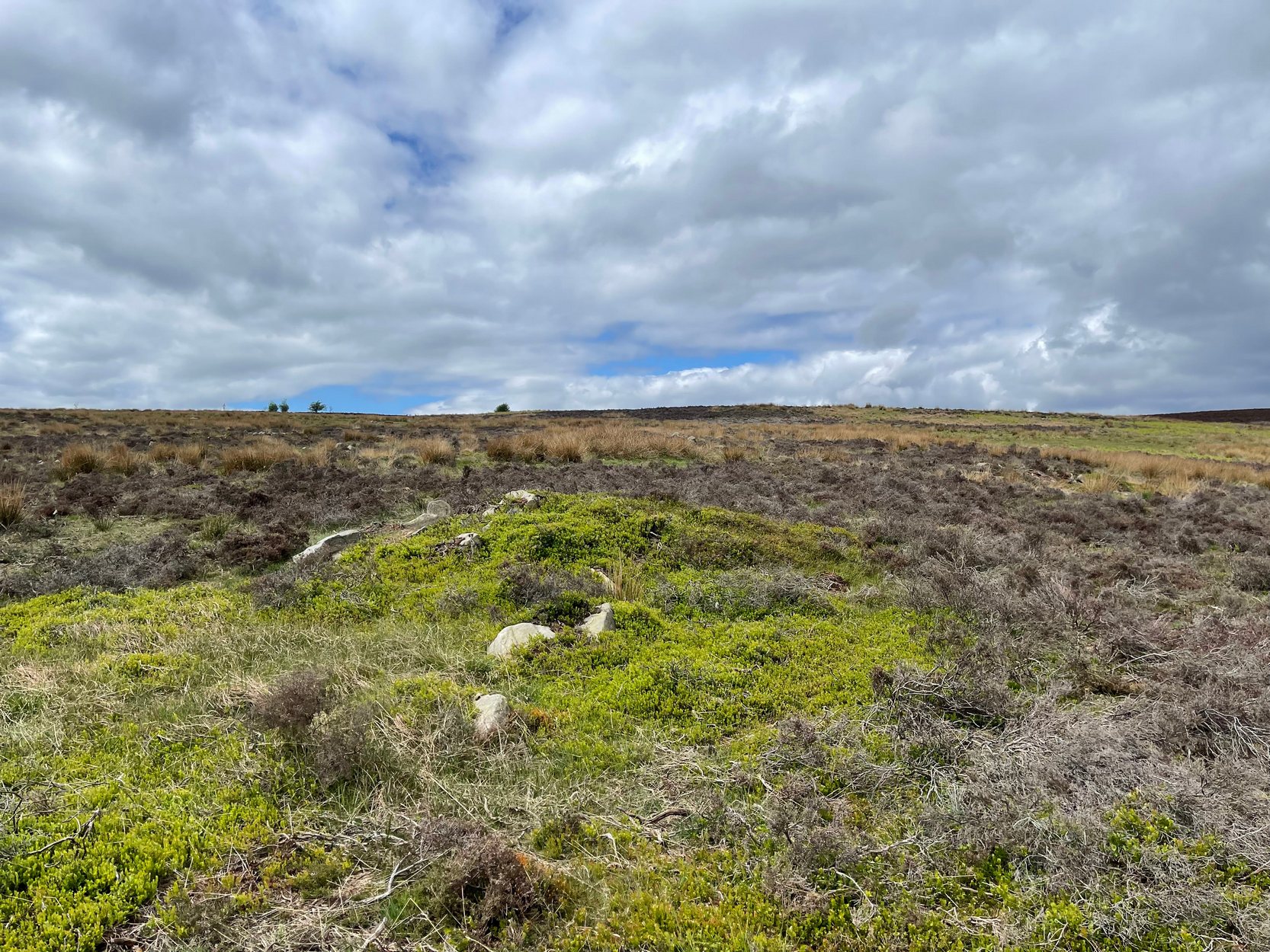
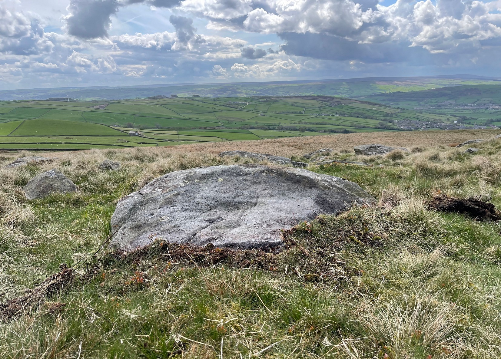
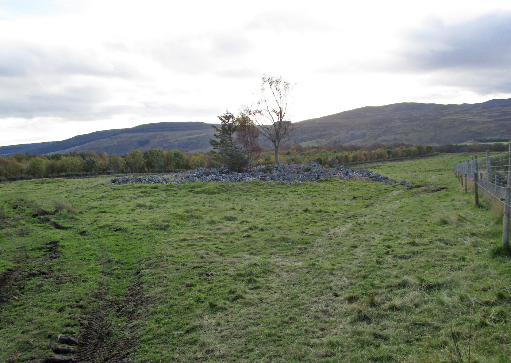
This is a relatively new find that was uncovered in 2019 by members of the Association of Certified Field Archaeologists, on the western edge of a small bowl of blackthorn trees, just past one of the Corrycharmaig East carvings — and it’s a bit of a beauty!

Topmost part of carving
Corrycharmaig (9) stone

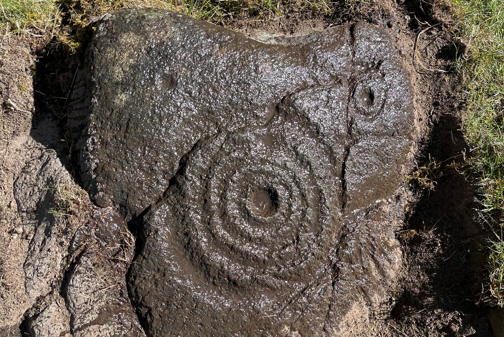
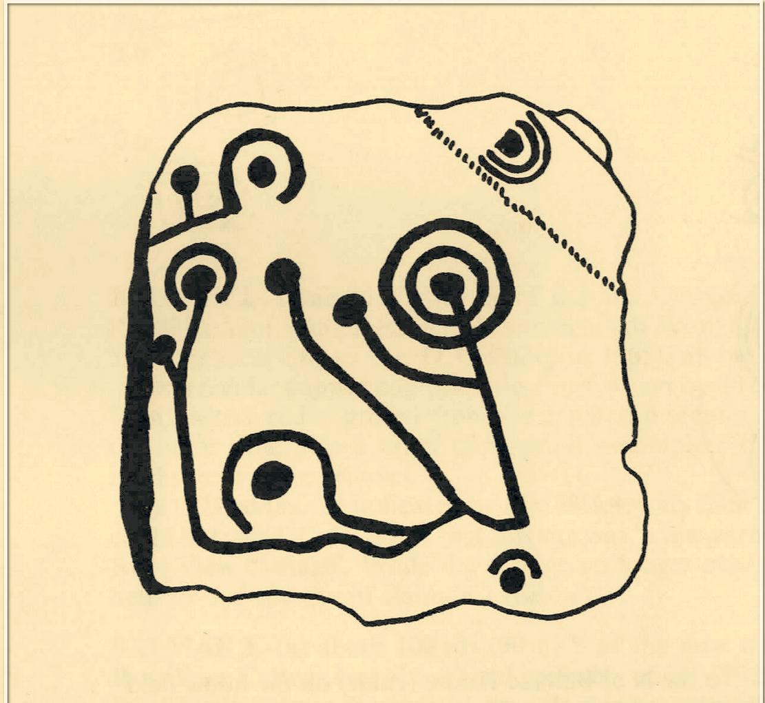
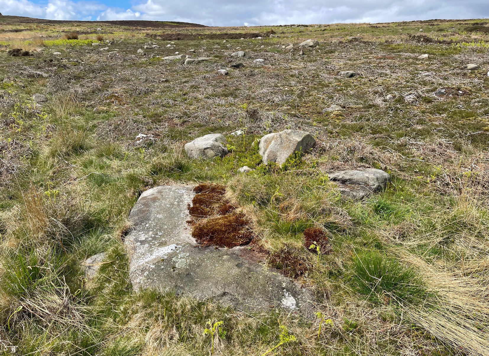
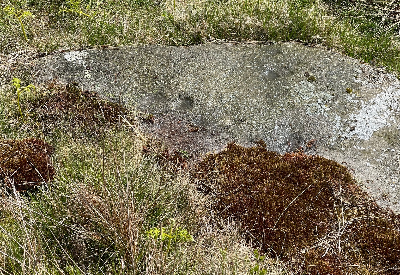
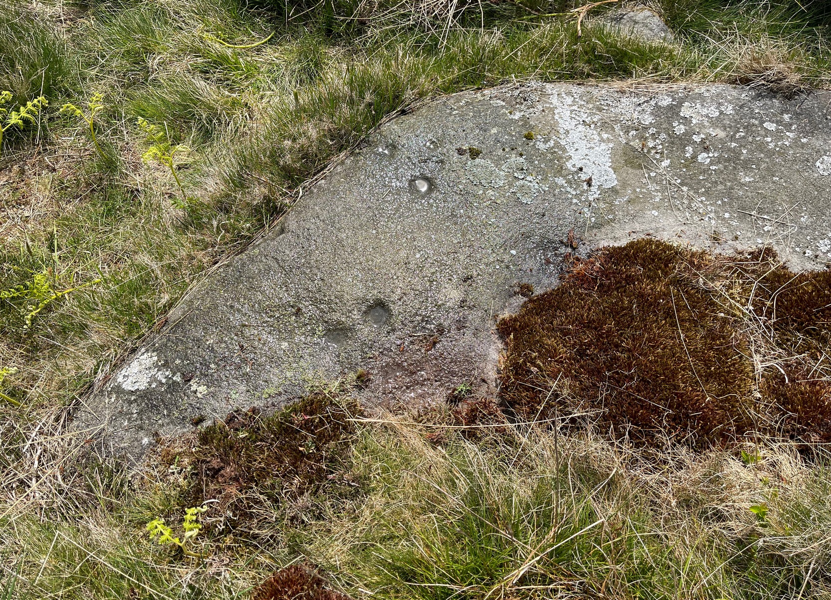
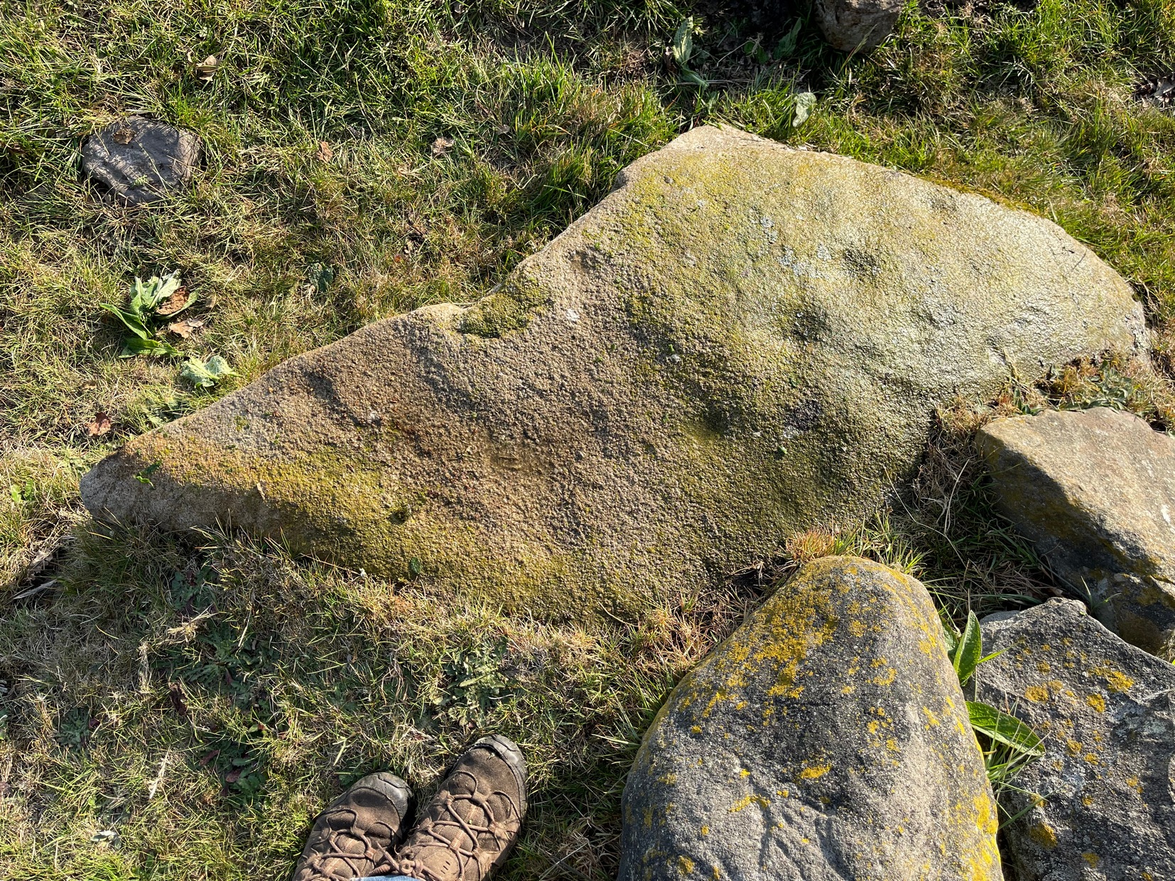
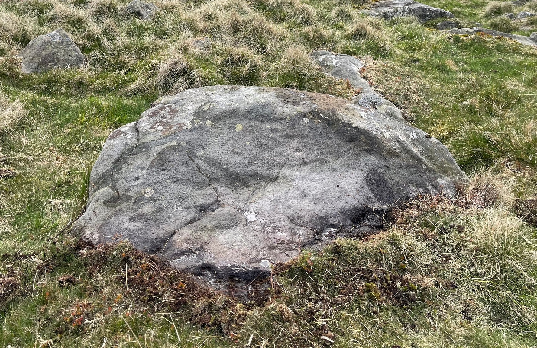
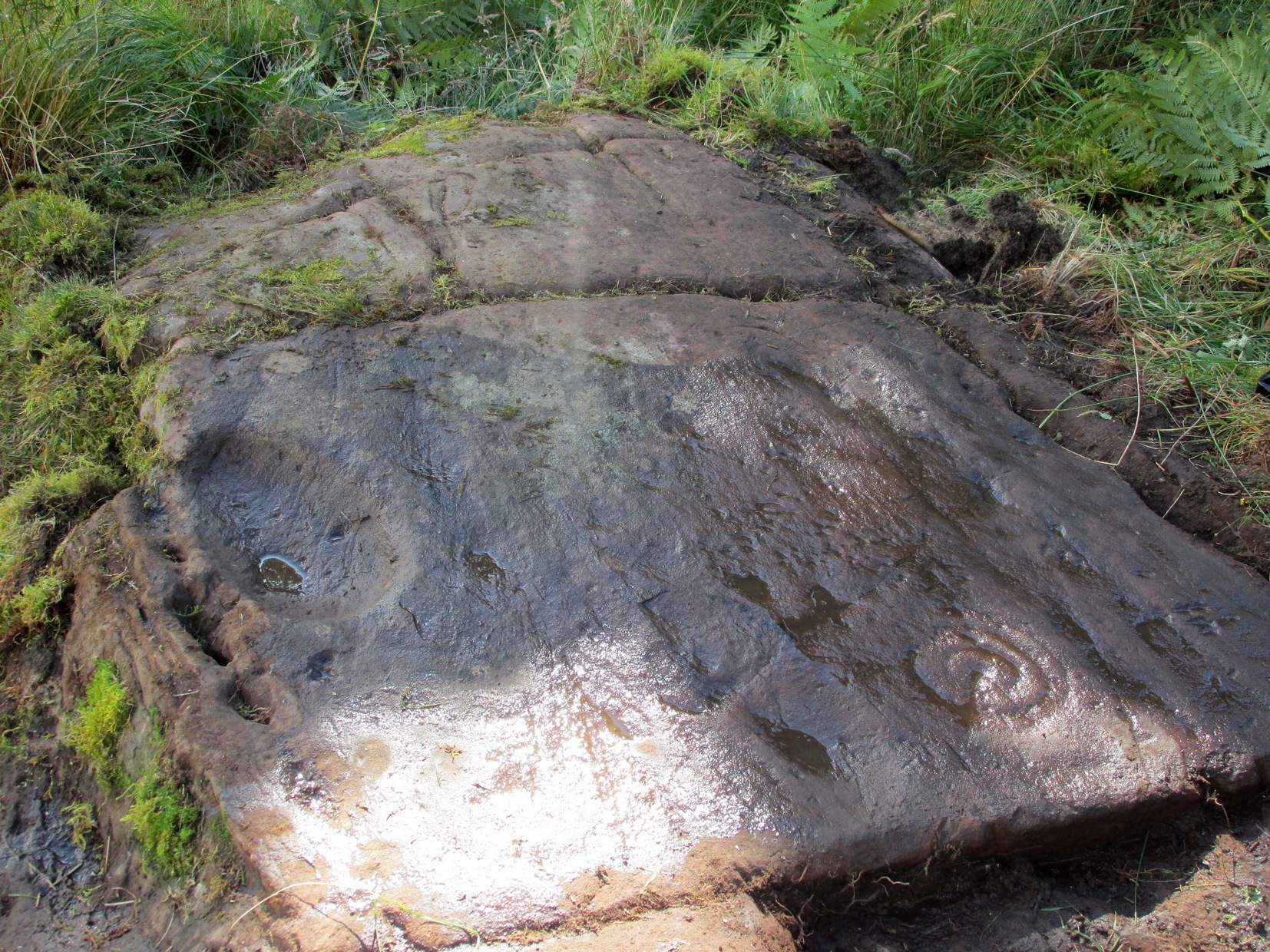
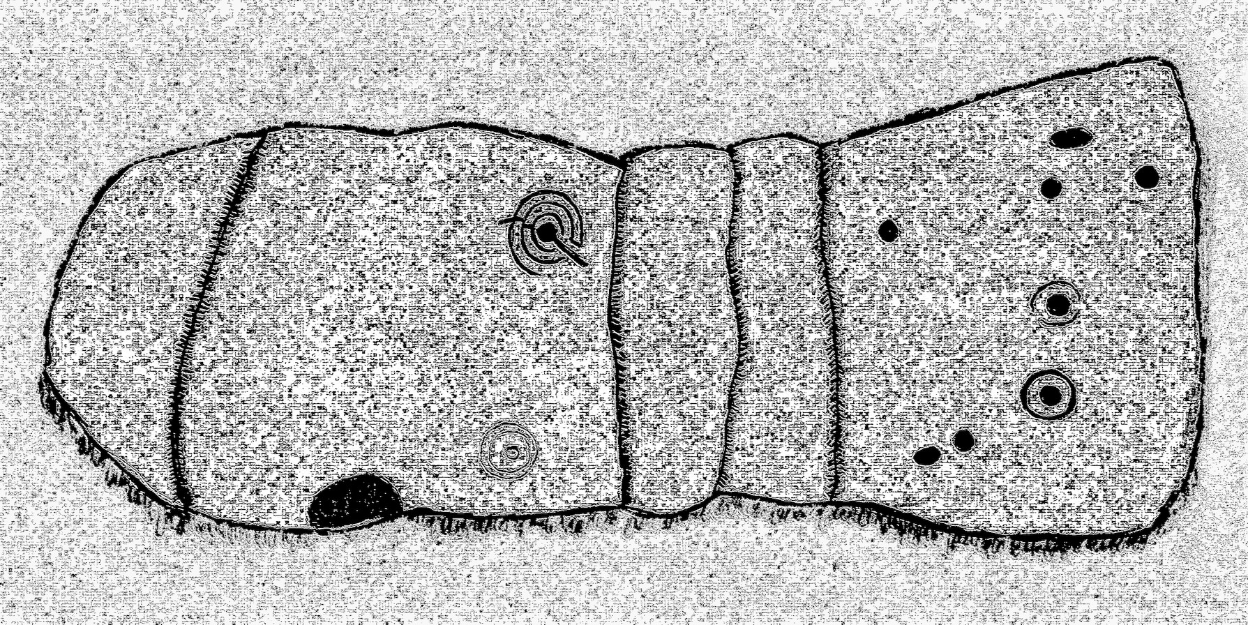
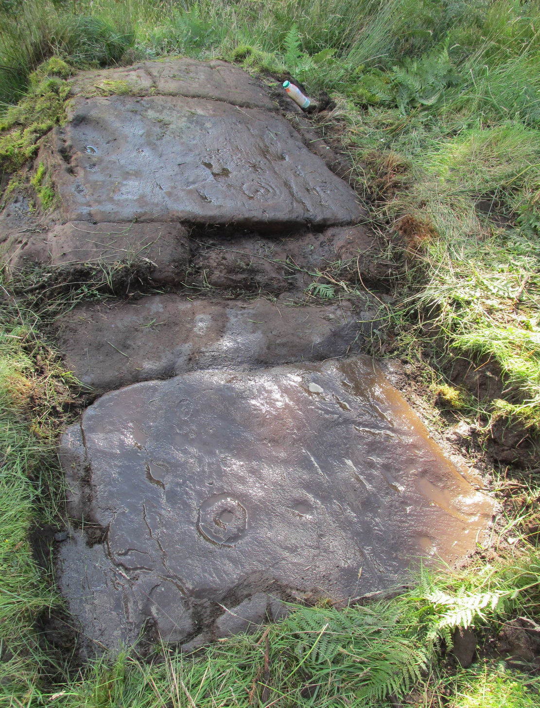
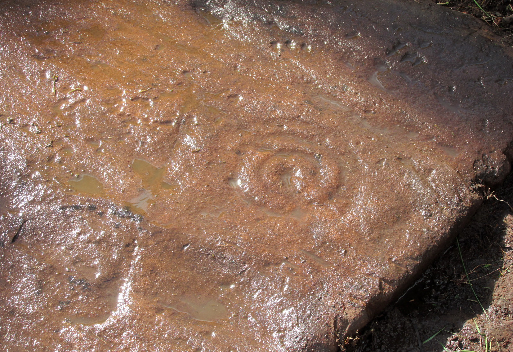
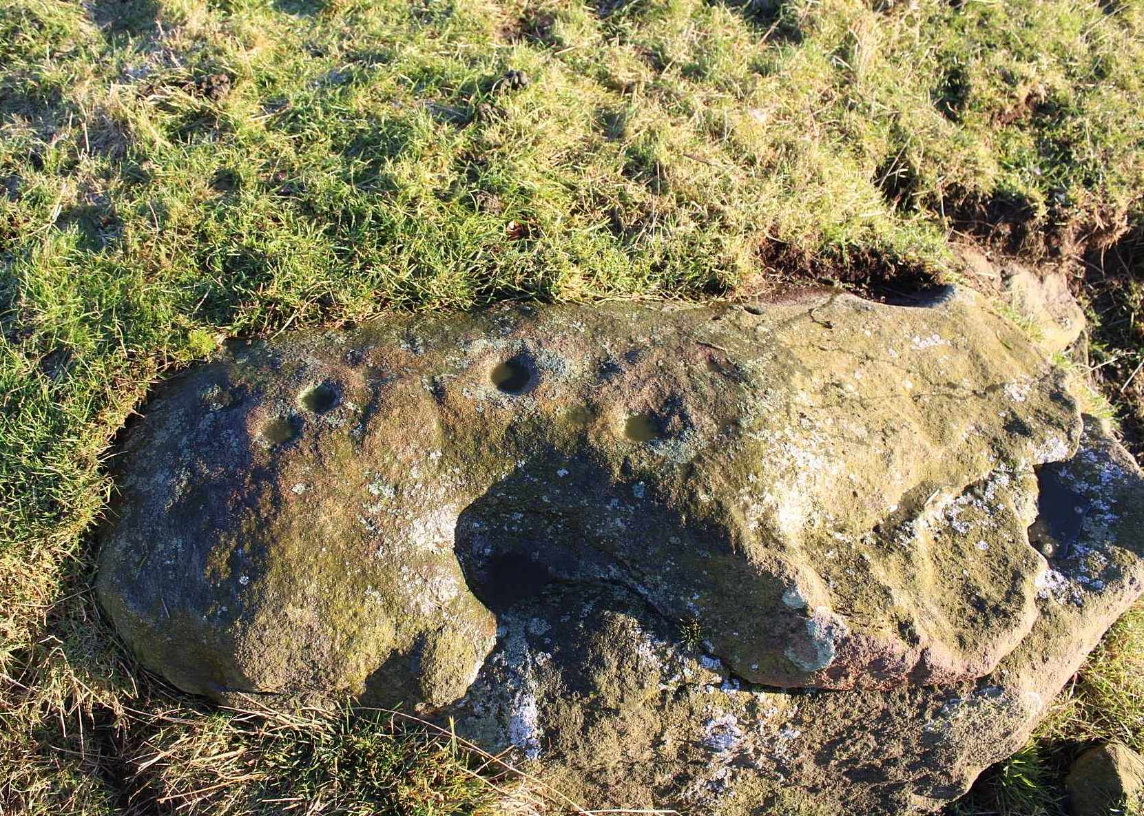
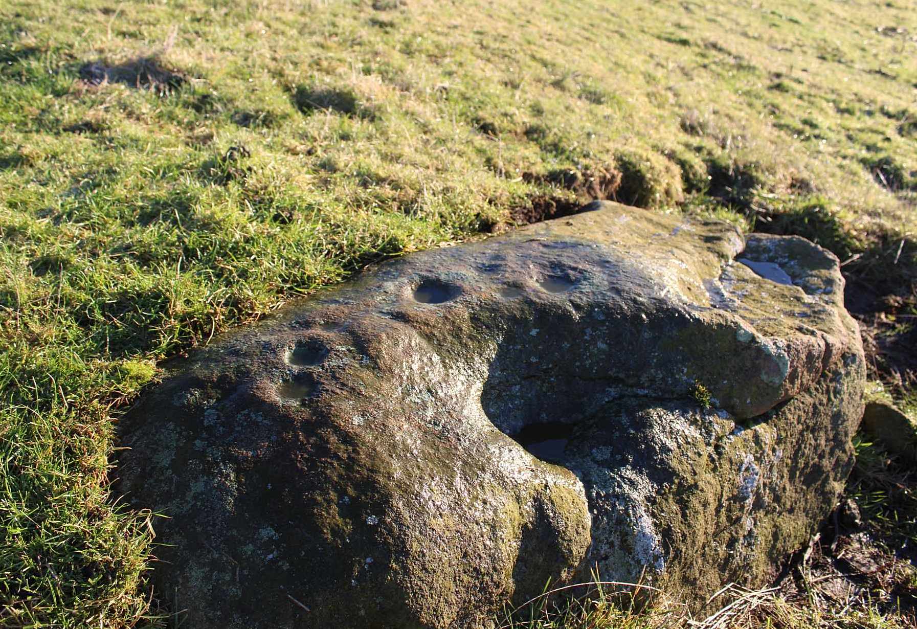
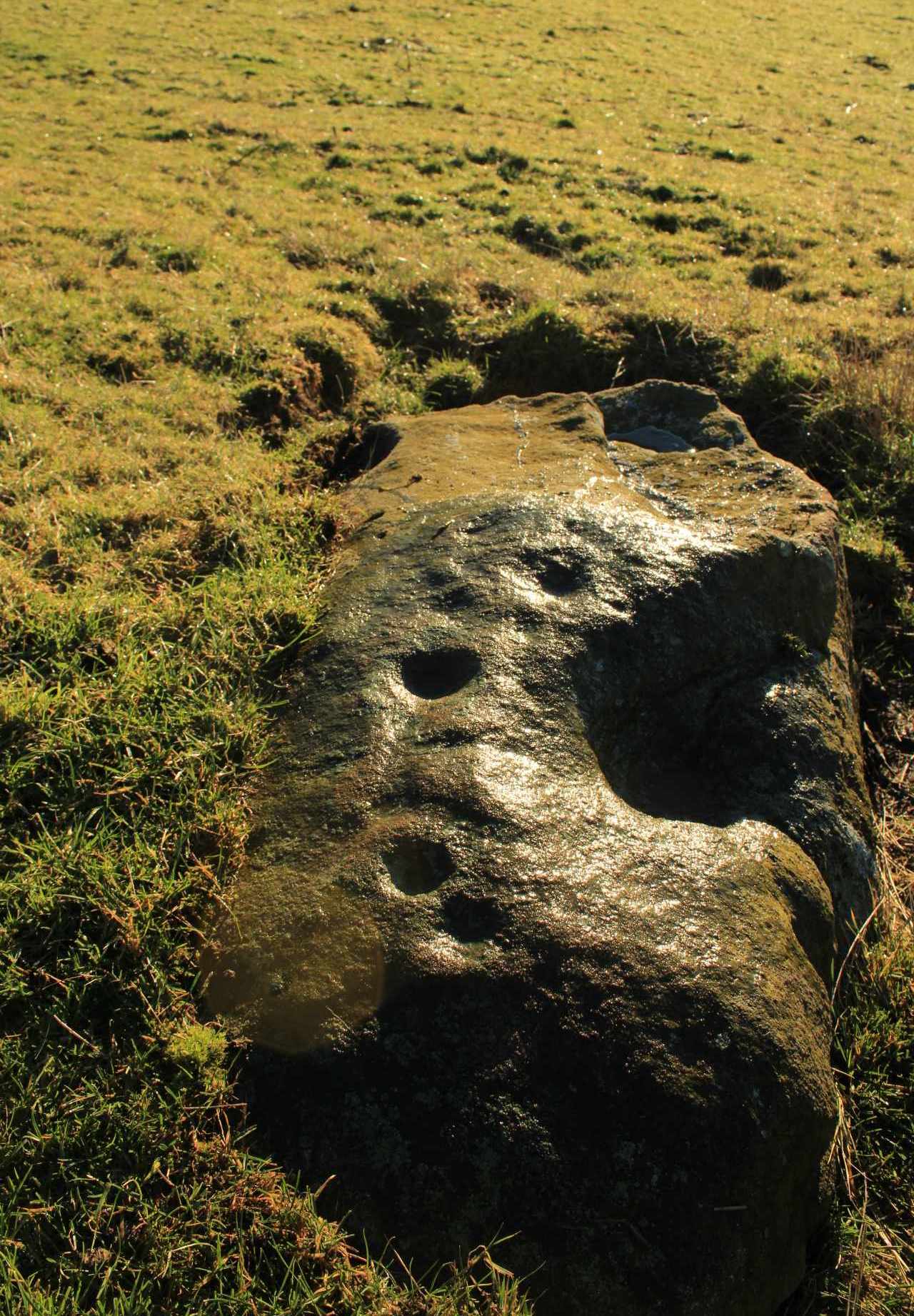
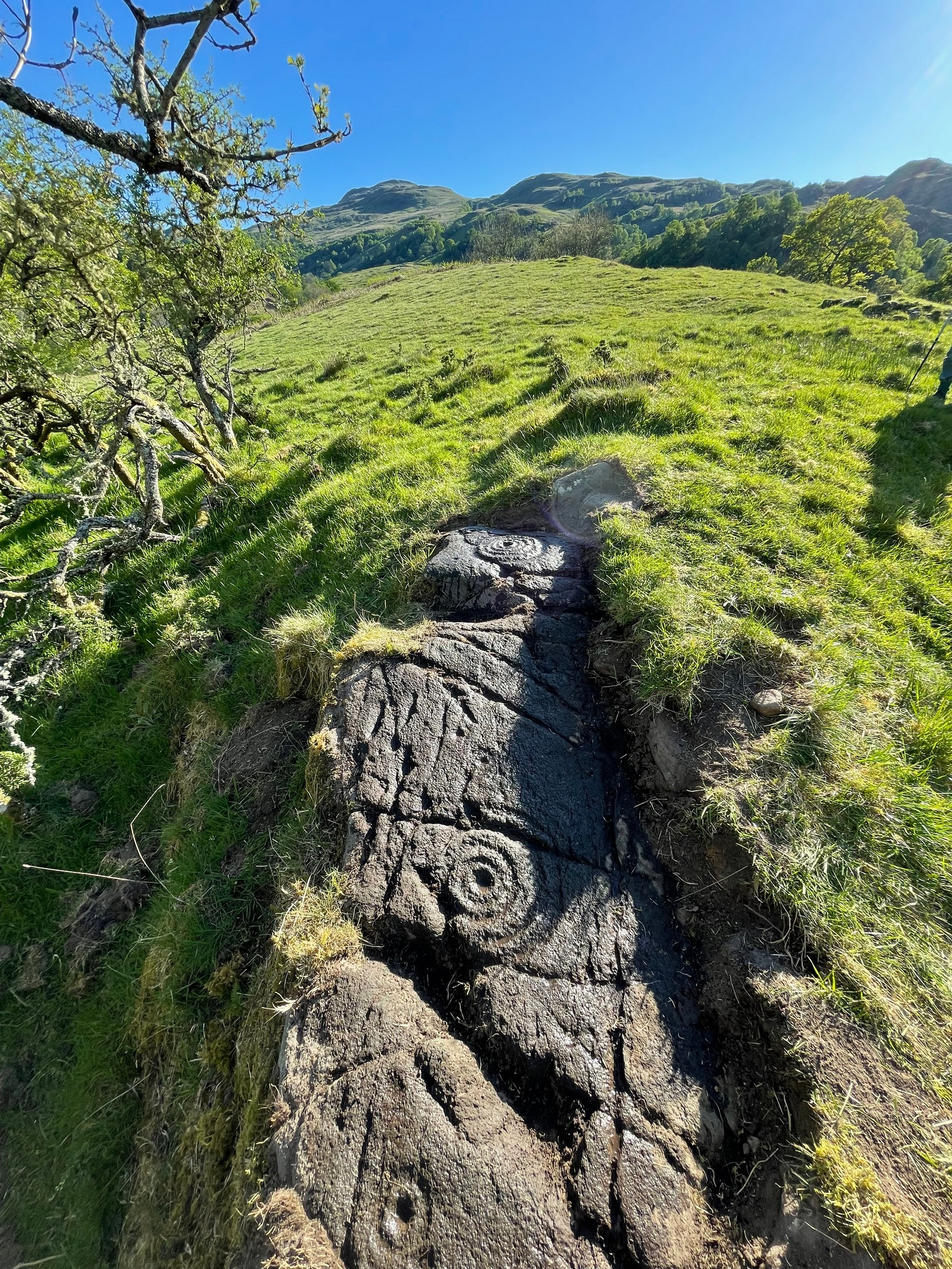
Described, albeit briefly, in the superb survey by Gardiner, King & MacInnes (2024), the carving here has been cut into a sloping straight line of rock along the ridge of a very tiny cliff and consists of cups, single rings and multiple rings.  At its crown, so to speak, where the rock surface levels out and is flat, a very well-preserved multiple cup-and-ring greets our senses: a cup-and-four rings to be precise.  The outermost edge of the rings cuts into a natural crack that runs to the edge of the stone; and close to where this crack reaches the edge, another standard cup-and-ring rests against it.  On this same section you’ll see a single cup which, by the look of it, was intended to have a much wider ring surrounding it—but for some reason it was never executed.

Second multiple-ringer
Second multiple-ring

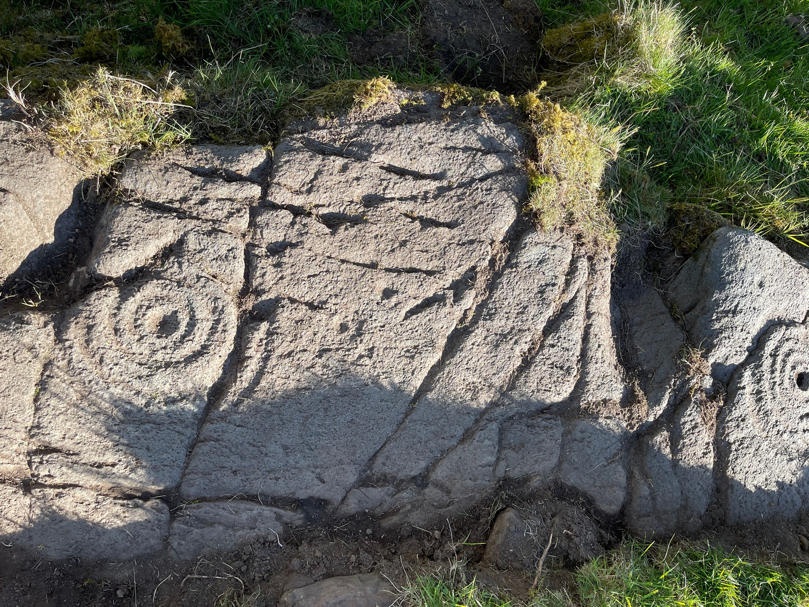
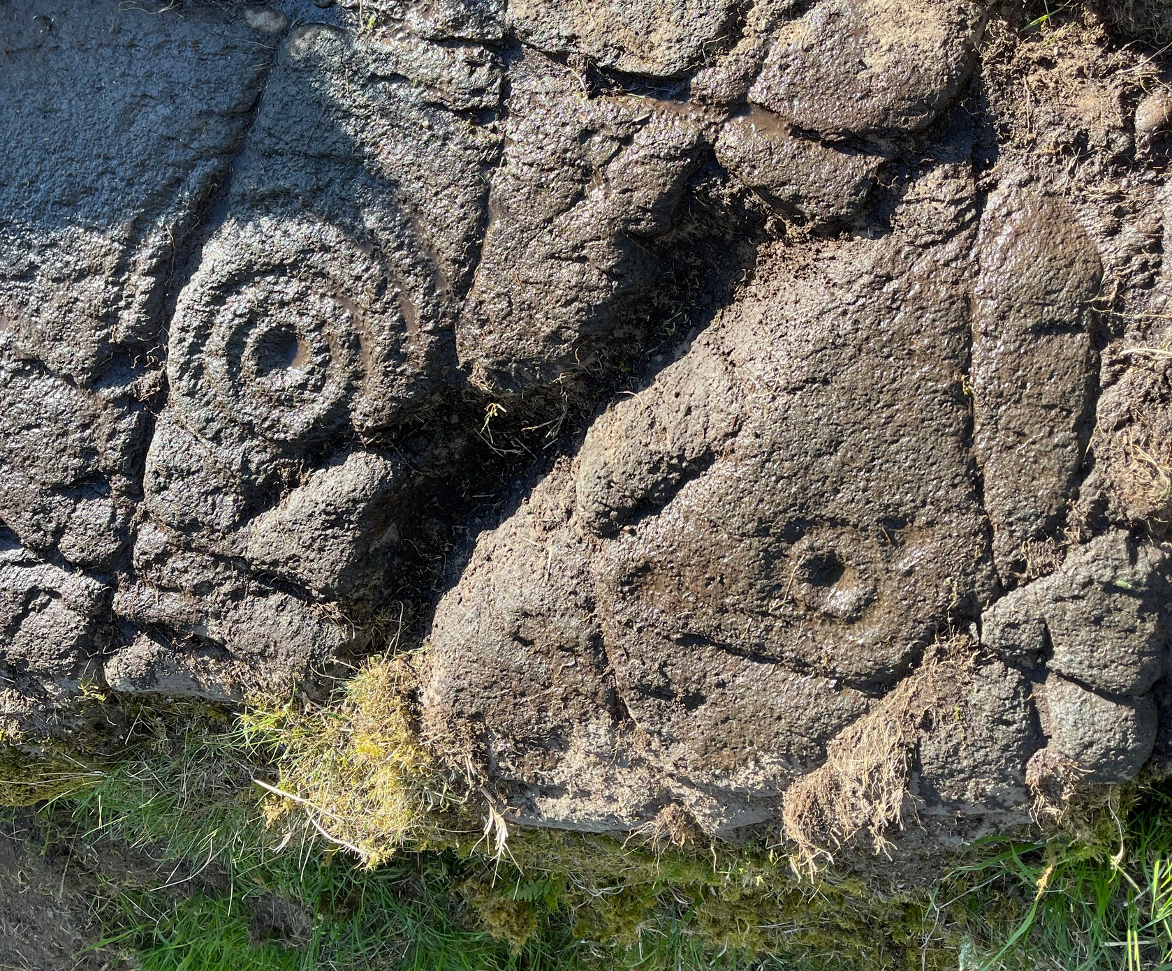
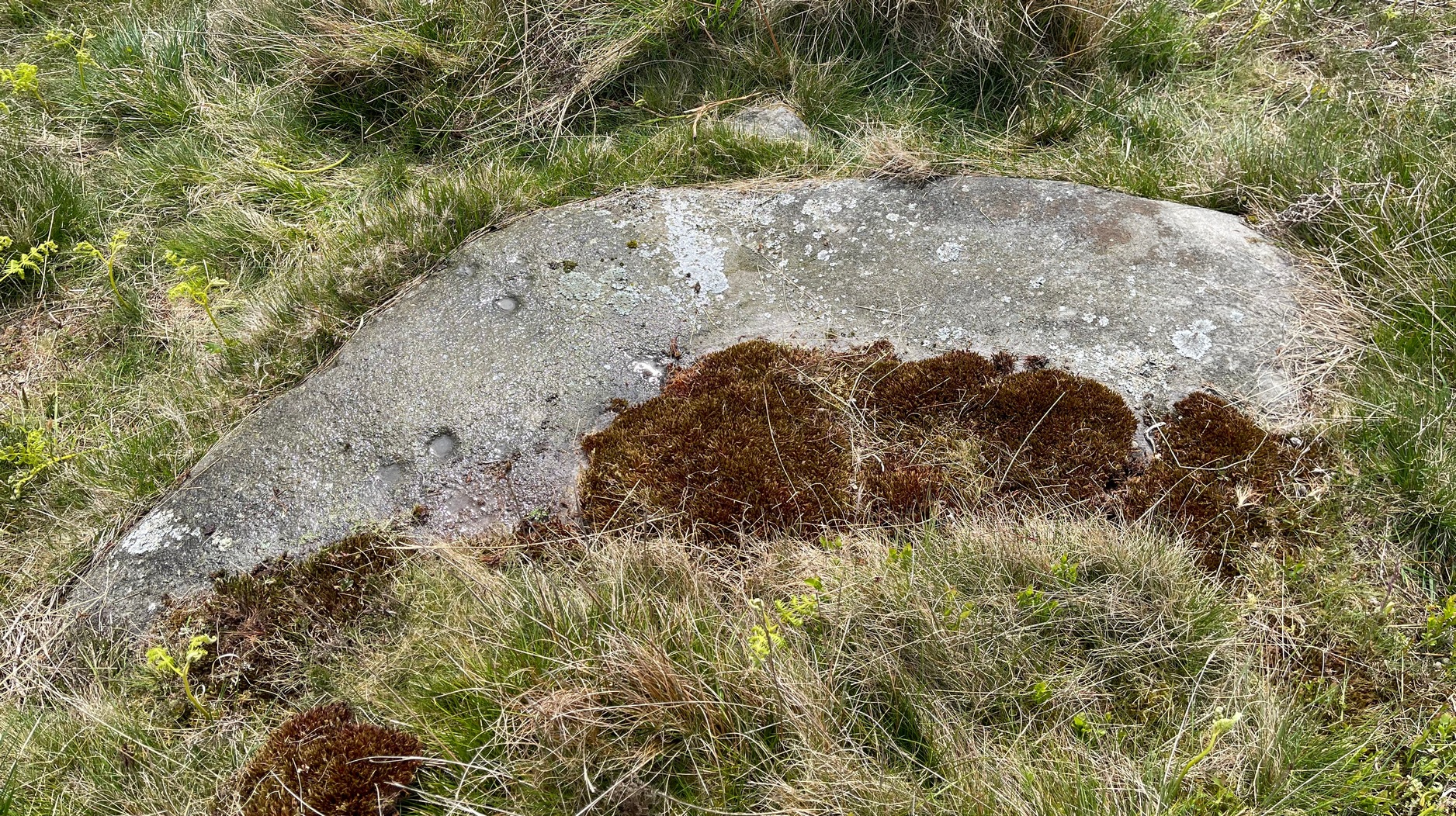
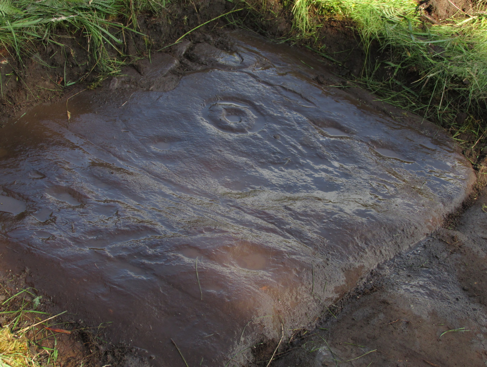
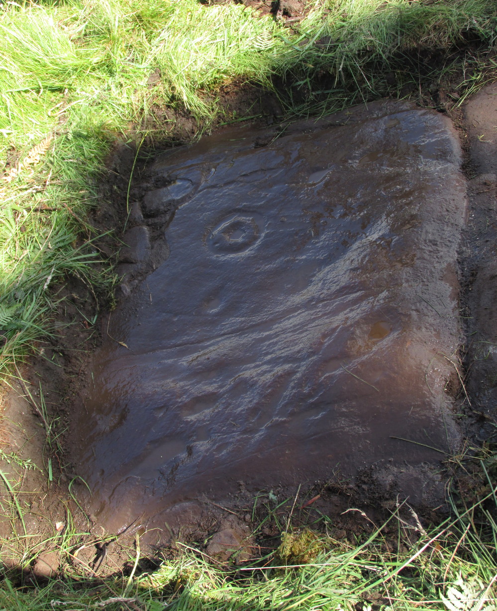
From the topmost section, the rock then slopes gradually downward and the design is broken by several natural splits in the stone before we reach a single unfinished cup-and-ring and a solitary cup-mark.  These occur shortly before we reach a near-duplicate of the multiple-ringer that we’ve just seen on the flat top of the stone.  The outer ring of this is broken and the edges of it are intruded (again) by natural cracks in the stone (a not uncommon feature).  The erosion level of this and its fellow four-ringed compatriot at the top are much the same, suggesting that the two were executed at around the same time.

Lower-half with cup&rings
Close-up of cup&rings

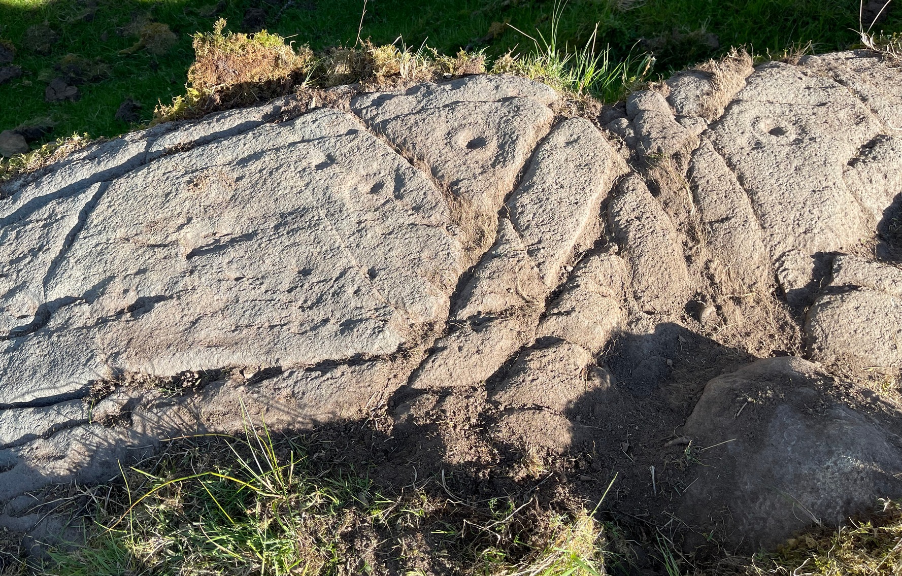
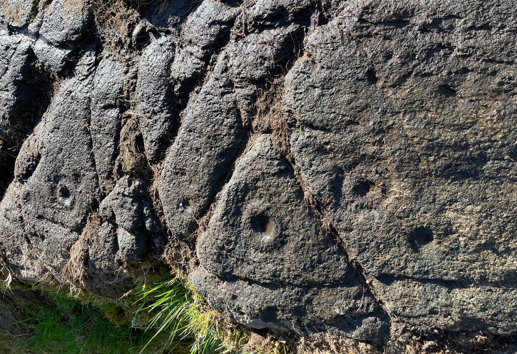
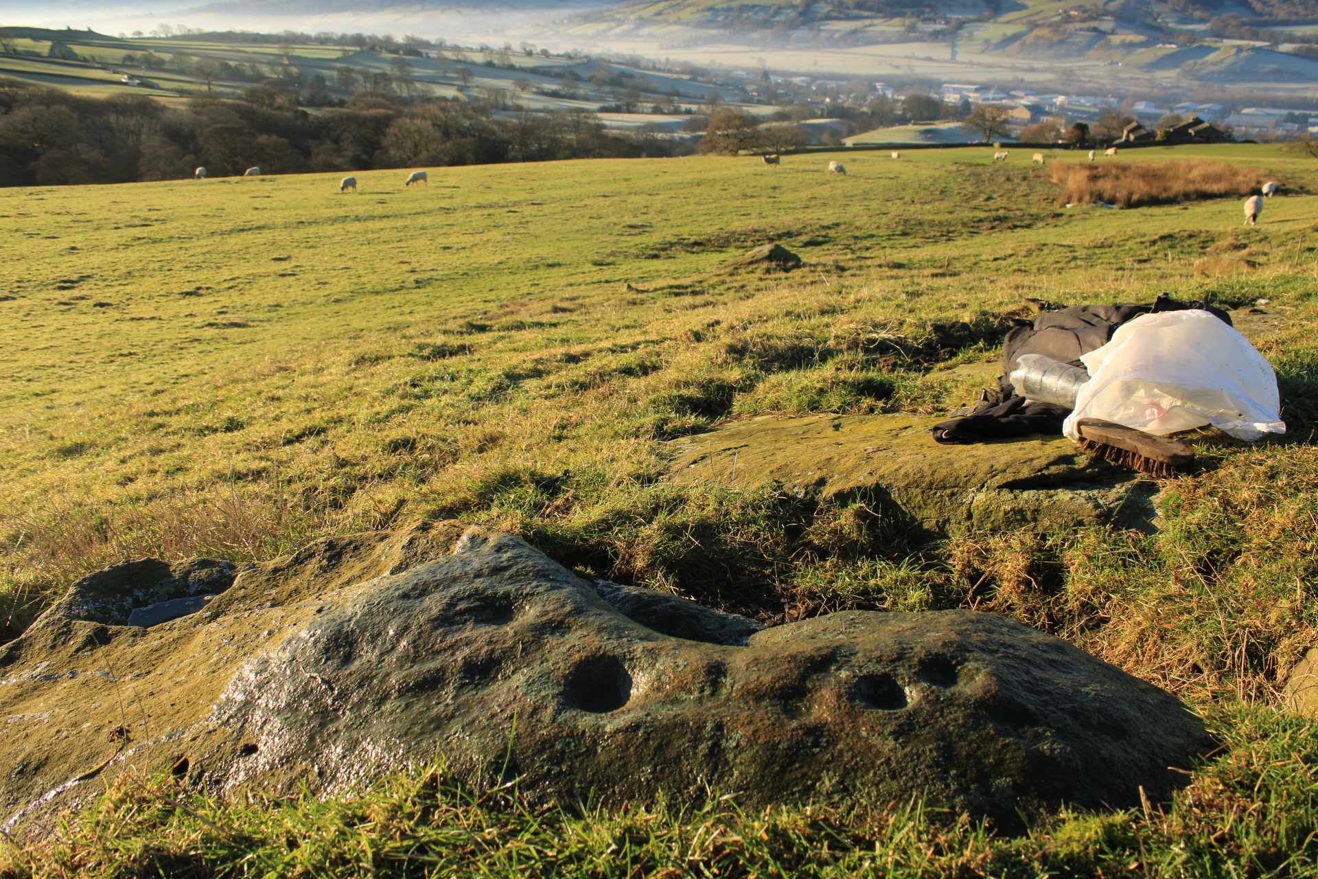
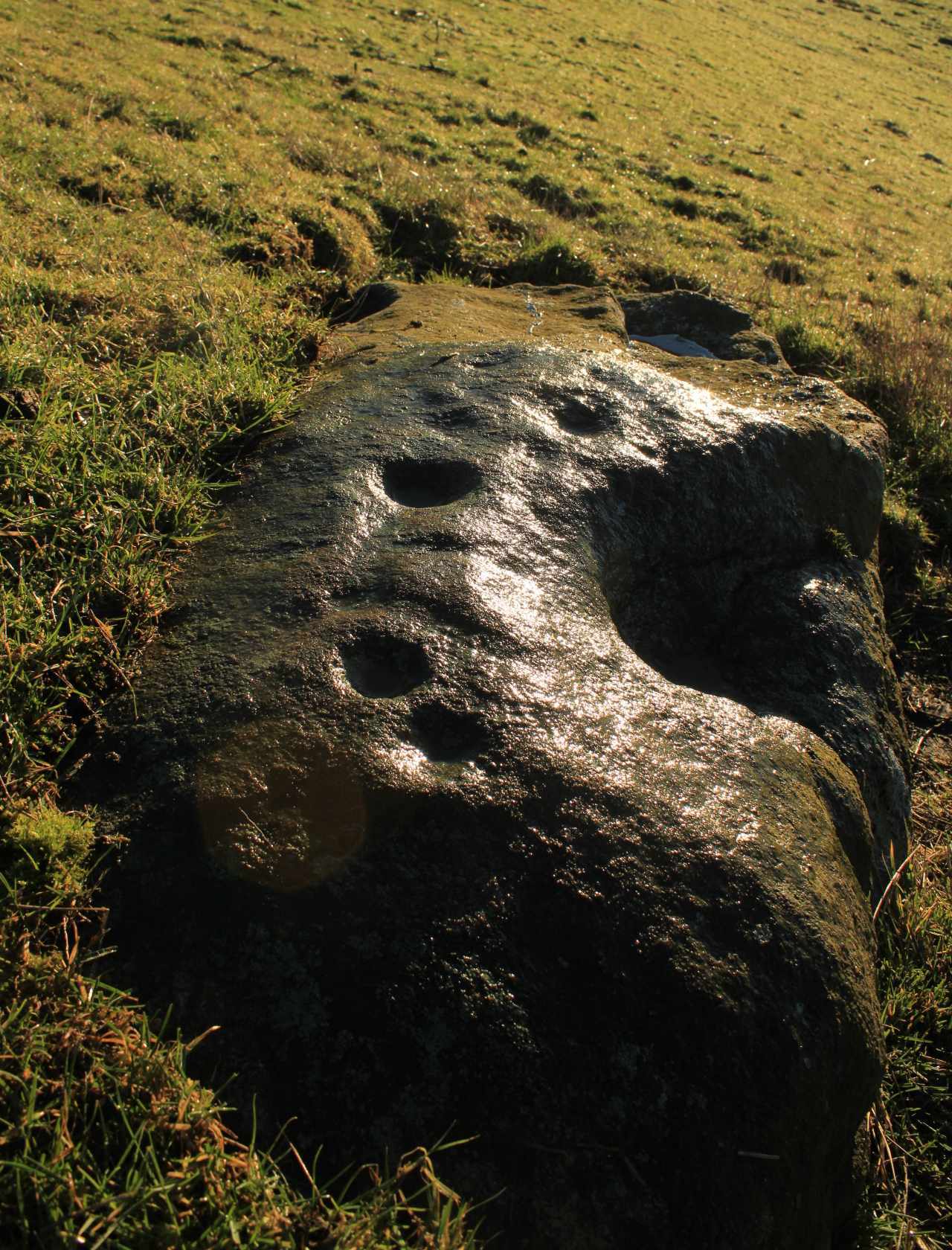
As we move down the slope of the rock with its veritable scattering of geological splits, the rest of the design consists of several single cup-and-rings—at least three of them—over its lower-half, almost in a gentle arc over the surface.  The one closest to the four-rings has a single cup-mark attached to its outer edge and another single one just a few inches away from it.  The others don’t seem to have any additional carved features attached to them; although one or two other singular cup-marks can be seen on this, the lowest section of the carving.

Looking to the hills
From the bottom up

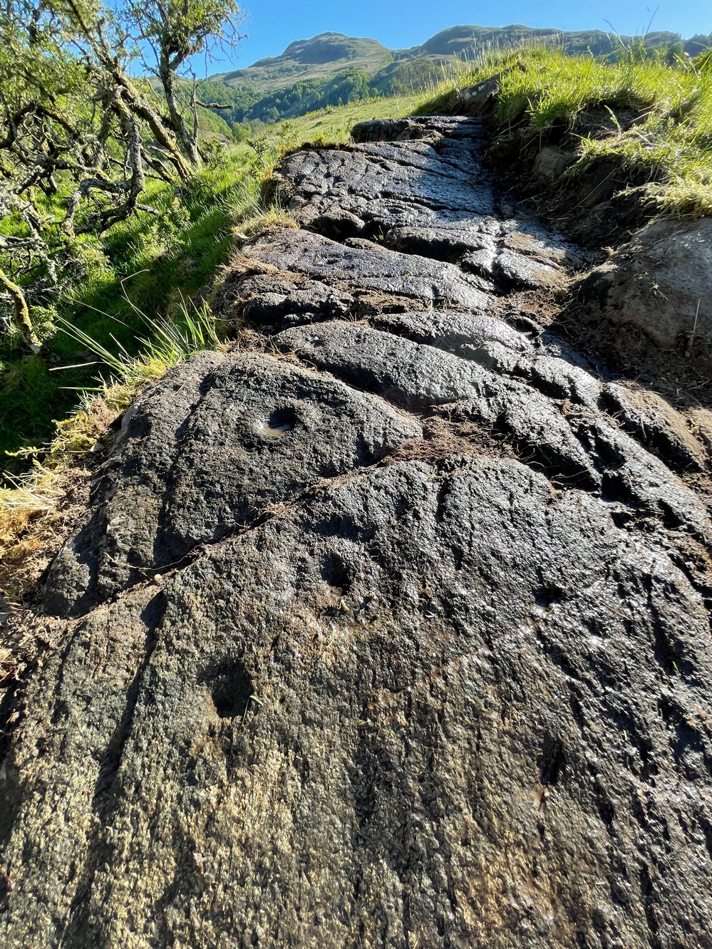
An interesting feature noted here is the direction that this line of rock points to: a dip between two distinct rocky peaks on the horizon and which is close to the winter solstice sunset.  I should point out however, that the relationship between open air petroglyphs and astronomical alignments (in Britain at least) is very debatable.  Even alignments from one carving to another are pretty meaningless, despite the attempts of some modern archaeologist to show otherwise.  In my younger days when I raced into rock art studies, I threw everything I had to show astronomical and other alignments were involved in these carvings—but it turned out not to be…. Instead, it turns out that some of these seeming ‘alignments’ (and only a few) relate to pathways and ancient routes: pointers, if you like, to the way ahead.  Makes sense…

References:

  1. Gardiner, M., King, L. & MacInnes, Dugald, In the Glen of the Dark Goddess, Bell & Bain: Glasgow 2024.

Acknowledgements:  Huge thanks for use of the Ordnance Survey map in this site profile, reproduced with the kind permission of the National Library of Scotland

© Paul BennettThe Northern Antiquarian

Bardristane (1), Anwoth, Kirkcudbrightshire

Cup-and-Ring Stone (lost):  OS Grid Reference – NX 529 528

Also Known as:

  1. Bardriston

Archaeology & History

In a region possessed with a good number of cup and ring stones, this one on the lower slopes of Barholm Hill may have once been part of a prehistoric tomb, or cist cover.  A fairly decent design had been carved onto a small flat slab of stone which, when uncovered in the 19th century, doesn’t seem to have been in its original position.  As the great Fred Coles (1894) told us:

Coles’ 1895 sketch

“The Bardristan slab…was removed from amongst the stones of an old drain in 1889, and, through Mr Kinna’s care, it is now preserved at Bardristan.  The evident attempt to square the stone itself; the extreme smallness of the rings ; the direct connection of the grooves, in all cases but one, with cups; and lastly, the vivid sharpness of the whole sculpturing, in which the tool-work is clear much beyond the ordinary, all combine to render this Bardristan slab unusually interesting and valuable.”

Less than twenty years after Coles’ description, the Royal Commission (1914) lads visited the site hoping to make their own assessment, but the carving had already been lost.  Referring to Coles’ account, they told how,

“inquiry there failed to elicit information concerning it, and it appears to have been lost. Mr Coles’ illustration…shows in the general intercommunication of the various cups a feature which characterises the stone at Kirkclaugh, about ¼ mile to the south of Bardriston.”

In the subsequent commentaries on this carving by Ron Morris (1967; 1979) and A.E. Truckell (1961), its whereabouts remained a mystery and, to this day, we know not what became of it…

References:

  1. Coles, Fred R., “A Record of the Cup-and-Ring Markings in the Stewartry of Kirkcudbright,” in Proceedings of the Society of Antiquaries Scotland, volume 29, 1895.
  2. Morris, Ronald W.B., “The Cup-and-Ring Marks and Similar Sculptures of South-West Scotland,” in Transactions of the Ancient Monuments Society, volume 14, 1967.
  3. Morris, Ronald W.B., The Prehistoric Rock Art of Galloway and the Isle of Man, Blandford: Poole 1979.
  4. Morris, Ronald W.B. & Bailey, Douglas C., “The Cup-and-Ring Marks and Similar Sculptures of Southwestern Scotland: A Survey,” in Proceedings of the Society of Antiquaries, Scotland, volume 98, 1967.
  5. Royal Commission Ancient & Historical Monuments & Constructions of Scotland, Inventory of Monuments and Constructions in Galloway – volume 2: County of the Stewatry of Kirkcudbrightshire , HMSO: Edinburgh 1914.
  6. Truckell, A.E., “Cup-and-Ring-Marked Slabs in the Cairnholy and Auchinlarie Area,” in Transactions of Galloway & Dumfriesshire Natural History & Antiquarian Society, volume 40, 1961.

Acknowledgements:  Huge thanks for use of the Ordnance Survey map in this site profile, reproduced with the kind permission of the National Library of Scotland

© Paul BennettThe Northern Antiquarian

Snowden Carr, Askwith, North Yorkshire

Cairnfield:  OS Grid Reference – SE 1777 5099

Getting Here

Cairns, front & rear

Park up at the singular dusty car-park on the east-side of Askwith Moor Road.  If you walk to the sloping eastern edge of the car-park and then go down and over the collapsed fence onto the moorland immediately east, walk in the direction of the Tree of Life Stone to the north-east (be aware that there’s no footpath here and it’s boggy as fuck in places) .  Just over halfway towards the carving, nearly 400 yards from where you’ve parked, you’ll begin to see various ruinous piles and scatters of stone.  You can’t really miss them!

Archaeology & History

Cairn, looking north

In a region teeming with prehistoric sites, the great Eric Cowling (1937) seems to have been the person who stumbled across this “barrow group”, as he called it, during one of his rock art forays in this neck o’ the woods.  Little has been written of them since.  Not to be confused with the Snowden Moor cairnfield more than 350 yards to the north, at this place we find at least a dozen quite distinct cairns scattered around the grid-reference cited, most of them much larger in size than the cairns to the north, ranging between five to twelve yards across and up to three feet high.  They have all been opened and robbed, with considerable disturbance on the largest of the ‘barrows’.  We know not who may have done this, but there’s been a history of quarrying close by and it may have been some of the workmen who did the damage, knowingly or otherwise.

Large scatter of cairn-spoil
Cairn covered in bilberries!

As far as I’m aware, no burial or funerary remains have been found here—but there’s been negligible archaeological attention given to any of the sites on this moorland, meaning that we can draw no real conclusions about the nature of the cairns.  They seem to be far too large to be clearance cairns; and the proximity of large scale prehistoric settlements and rock art all round here would strongly suggest they possessed a funerary nature.  Several impressive petroglyphs exist right at the edge of this group, literally yards away from them.  Check them all out out the next time you see the Tree of Life stone

References:

  1. Cowling, Eric T., ‘Cup and Ring Markings to the North of Otley,’ in Yorkshire Archaeological Journal, volume 33 (part 131), 1937.
  2. Cowling, Eric T., Rombald’s Way: A Prehistory of Mid-Wharfedale, William Walker: Otley 1946.

© Paul BennettThe Northern Antiquarian

Snowden Carr (596), Askwith Moor, North Yorkshire

Cup-Marked Stone:  OS Grid Reference – SE 17959 51141

Getting Here

Carved stone in foreground

If you’re looking for this carving, you’ll have been to the impressive Tree of Life stone first.  From there, you need to walk further away from the walling, 30-35 yards southwest, across the other side of the footpath.  There’s a scattered mass of stones all over the ground here: you’re looking for a low-lying long curved stone—longer than most of them hereby.  If the heather’s grown back over the stone, it might take some finding!

Archaeology & History

Close to a line of prehistoric walling (seemingly a section of a settlement), this typically curvaceous female stone is possessed of two pairs of faint cup-marks on the eastern side of the rock.  It was included in Boughey & Vickerman’s (2003) survey where they described the carving as being, “two small cups visible and two further cups under heather.”  A third possible cup exists close to one of the pairs. The carving is found in an area rich in untouched prehistoric remains. 

References:

  1. Boughey, Keith & Vickerman, E.A., Prehistoric Rock Art of the West Riding, WYAS 2003.

© Paul BennettThe Northern Antiquarian


Intake Farm, Hawksworth, West Yorkshire

Cup-Marked Stone:  OS Grid Reference – SE 15867 41244

Getting Here

Intake Farm carving

In Hawksworth village, less than 100 yards past the primary school, take the footpath on your left into the open fields.  200 yards down the fields, go over the stile on your right, into the next field and walk diagonally across it (SW) for 250 yards until you reach the wall; then walk alongside it, west, for another 150 yards where the walling goes due south and walk down here for 135 yards, going through the gate at the bottom into the next field and, at the bottom of this one go through the gate and bear right.  OK, now walk along the wall-side for 55 yards and you’re just about standing on it!  Alternatively you can reach it via the Hawksworth Spring (1) and (4) carvings, following the wall along for roughly 150 yards till you reach the gate. Go through here and walk diagonally NNW across the field for nearly 150 yards where you’ll see the stone stuck out in front of the wall.

Archaeology & History

My first sight of this came about as I walked alongside the walling.  Approaching the stone, I noticed what looked like a recent cup-like marking with a curved line emerging from it on its eastern surface; but it didn’t look too old and was more like the scratch-marks you see sometimes when farmers have been dragging rocks along to be used in walling.  So I shrugged in slight disappointment—until the far-side, the western-side of the stone came into view.

Line of cups

Main scatter of cups

Sloping ever-so-slightly down into the ground, the surface of the stone had a cluster of quite worn, shallow, but distinct cup-markings between one and two inches across, four of which ran in a line from the top to the edge of the stone in a slight curve.  As I walked round it, looking from different angles, it became obvious that two or three other cups existed—mainly from the top to the western side of the rock.  One seemed to exist near the edge, whilst two other faint ones sat to the side of the line-of-four—almost creating a square formation.  From some angles it looked as if there may be faint lines running between some of the cups but (as usual) the sunlight didn’t really help highlight them and they could just be faded erosion lines.

Looking down at the cups

Water & sunlight & cups

It was obvious that a section of the stone on its southern edge had been broken off in the not-too-distant past, raising the idea that the design may originally have been larger than its present form.  This thought returned when I walked another 60 yards west along the wall and came across a broken section of stone that had been placed into it, pretty recently, and on its vertical face noticed a single cup-mark in a good state of preservation, indicating that it had either been cut recently or instead been dug out of the ground not too long ago and shown intself to the world after a sleep of several millenia.  Look at it when you have a gander at the main carving here and make up your own mind….

© Paul BennettThe Northern Antiquarian

Millstone Hill, Bradley Moor, Skipton, North Yorkshire

Cup-and-Ring Stone:  OS Grid Reference – SE 01343 50223

Getting Here

Millstone Hill carving

In High Bradley village, you need to go up Mill Lane for 140 yards and then bear left up High Bradley Lane for just over a half-mile, past the last row of houses on your left where it becomes a dirt-track and park-up a short distance up here. 400 yards up, in the field past the new house on your left, walk up the hill over the field, past the wall at the top and head for the large protruding boulder a few hundred yards further up on the near skyline.  Once here, walk to the right of it and there’s a scatter of rocks and stones.  Look around!

Archaeology & History

In an area that was extensively cut up by the Industrialists in the 18th and 19th century, Thomas Cleland came across this scarce example of a cup-marked, possibly cup-and-ring marked stone in March 2025 high up on Millstone Hill, where extensive views reach out to the south, east and west, gazing with particular attention to the mightily impressive King and Queen’s cairns, more than 1½ (2.6km) south of here—and which would have stood out much more back then than they do today.

Close-up of faint arc

An arc of cups is faintly visible on the more western-side of the stone—five, perhaps six of them.  Several others are in a typically chaotic scatter across the rock, with one or two looking as if they may have been affected by the heavy industrial actions that occurred up here.  When Tom first found the carving, he could see a faint ring around one of the cups near the middle of the stone, but on our visit here the sun was near its apogee and due to the slope of the rock to the north where the cups are carved, this was nigh on impossible to make out.  Near the bottom edge however (as shown in the photos), a cup-and-incomplete ring seems evident; although we didn’t notice this on our visit here and it may just be a fortuitous play of the light (but I hope I’m wrong!).  This is a design that mainly comes to life, so to speak, is more easily visible, when the sun is either rising or setting. (typical of many petroglyphs on flat rocks)

Acknowledgements:  Huge thanks to Thomas Cleland for use of his photos in this site profile. 

© Paul BennettThe Northern Antiquarian

Riffa Wood, Leathley, North Yorkshire

Cup-Marked Stone (lost):  OS Grid Reference – SE 2556 4687

Also Known as:

  1. Carving no.556 (Boughey & Vickerman)

Archaeology & History

We know very little about this carving, which was first highlighted on Eric Cowling’s (1940) map of Wharfedale petroglyphs.  Described simply as one of the “cup-marked rocks”, he mentioned it briefly in Rombald’s Way (1946) as being “the most easterly carving” in mid-Wharfedale—which it was at the time (a very recent find by Benn Potts of a cup-marked stone at Weeton has pushed the boundary further eastwards).  Oddly for Cowling, he left no further notes nor sketch of the carving and when Stuart Feather (1961) came to write of it, he merely copied Cowling’s earlier words.  It’s not been seen since.  In Boughey & Vickerman’s (2003) survey, they could find no cup-marked stone in the wood but thought instead that,

“this may be due more to confusion than to loss of the carving.  Riffa Wood does contain a carving: of a Native American on a conspicuous rock alongside one of the many woodland paths. Furthermore, one or two local residents recall a German prisoner carving something on a rock in Riffa Wood during the Second World War.  Presumably, this is the origin of the Native American carving.  Could it be that this man added something of his own to what was already a carved rock, in which case the Native American as he now appears is the site noted by Cowling before the War?”

No cup-marks exist on this Native American carving, and it’s highly unlikely that Cowling would have made such an elementary mistake.  The carving no doubt lies covered in woodland vegetation waiting, once more, for the day that someone comes along and exposes its visage to the world again.  Let us know if you manage to find it…

References:

  1. Boughey, Keith & Vickerman, E.A., Prehistoric Rock Art of the West Riding, WYAS: Wakefield 2003.
  2. Cowling, E.T., ‘A Classification of West Yorkshire Cup and Ring Stones,’ in Archaeological Journal, volume 97, 1940.
  3. Cowling, E.T., Rombald’s Way: A Prehistory of Mid-Wharfedale, William Walker: Otley 1946.
  4. Feather, Stuart, “Mid-Wharfedale Cup-and-Ring Markings,” in Cartwright Hall Archaeology Group Bulletin, volume 6, no.3, March 1961.

Acknowledgements:  Huge thanks for use of the Ordnance Survey map in this site profile, reproduced with the kind permission of the National Library of Scotland

© Paul BennettThe Northern Antiquarian

Over Glenny (13), Port of Menteith, Stirlingshire

Cup-and-Ring Stone:  OS Grid Reference – NN 57047 02878

Getting Here

Over Glenny (13) section with ‘bowl’

Along the A81 road from Port of Menteith to Aberfoyle, watch out for the small road in the trees running at an angle sharply uphill, nearly opposite Portend, up to Coldon and higher. Keep going, bearing right past Mondowie and stopping at the dirt-track 100 yards or so further up on the left (ignore the english fuckers up here who tell you it’s a pwivate road and they don’t want you parking there—unless you’re blocking the road obviously!).  Walk up up here for ⅔-mile, as if you’re visiting the Over Glenny (5) carving, but as you get close to the defining sycamore tree, walk past it for about 60 yards towards the ruinous buildings. You’re looking for a reasonably large earthfast rock with a notable bowl about 12-inch across at the edge of the stone.  That’s your defining feature.

Archaeology & History

Arty sketch of the design

This is another decent design in the mass of petroglyphs on this plain overlooking the Lake of Menteith.  On our first visit here ten yeas ago, only one half of the rock was visible—and half of that was covered with grasses!  But with patience, we slowly rolled back the turf and slowly uncovered more and more, eventually seeing the main elements you can see in these photos and the arty sketch I’ve made here. (the Over Glenny [14] carving a few yards further east may be just be a continuation of this design)

Full length of the stone

The triple cup-and-ring

When the carving was first noticed by George Currie (2010), he only noticed “a cup mark surrounded by two penannulars, an arc and a single radial”—ostensibly meaning, a cup-and-triple ring, with the outer ring incomplete, and a line running out from the central cup.  But there’s more, obviously.  On our second visit, a very faint but distinct cup-and-double-ring was noticed in low light on the same section of the rock where the triple-ringed element is carved.  We weren’t able to get a photo that showed it, as the light wasn’t doing as we needed, but I’ve highlighted it on the sketch, where it’s to the right of the large ‘bowl’ at the very edge of the rock.  This ‘bowl’ probably had utilitarian functions, whether it was for just crushing herbs or grains, or to make organic paints: and this function most likely had some relationship with the petroglyph—but we know not what!  It’s possible that the people who lived in the adjacent ruin, several centuries ago, may also have made use of this.

East-end of the design

East-end angular pose

When we exposed the other half of the carving, a very well-cut and well-preserved cup-and-ring sat beside another much more eroded partner, which was almost impossible to see from some angles. You can just make it out in the photos here.  You’ll also notice a scatter of several other cup-marks and elongated ‘cups’ on the same section of rock.  It was difficult to work out whether some of these marks in the stone were Nature’s handiwork, or the result of human hands.  Some were obviously man-made, but we need to look at it again when the daylight conditions are good, so that we can make a more accurate assessment.

References:

  1. Brouwer, Jan & van Veen, Gus, Rock Art in the Menteith Hills, BRAC 2009.
  2. Currie, George, “Port of Menteith: Upper Glenny (UG 1), Cup-and-Ring Marked Rocks”, in Discovery & Excavation, Scotland, New Series – volume 11, 2010.

Acknowledgements:  Huge thanks to the crew: Paul Hornby, Lisa Samson & Fraser Harrick in making this carving come to life, and for use of a photo or two. 

© Paul BennettThe Northern Antiquarian

Grey Cairn carving, Kirkmichael, Perthshire

Cup-Marked Stone:  OS Grid Reference – NO 10058 57013

Archaeology & History

When the Grey Cairn above Balnabroich, Kirkmichael, was explored in the second-half of the 19th century by John Stuart (1865) and a number of local labourers, they found the floor of the tomb had been paved with a number of large boulders.  Near its centre, along with finding remains of charred wood, they moved some of the rocks and,

“On turning over the stones a circular disc of stone with a hole in the centre was found, and also a small boulder with a cup on its flat face.”

Grey Cairn at sunfall

He made no further remarks about the carving and no intimation that it was removed, so we must presume it is still there, at the botton of the cairn.  Any visitors to the site might want to have a look at the massive scatter of surface stones that make up the cairn to see if any further cup-marks exist on them.  It’s not uncommon to find them on such giant tombs.

Folklore

A very curious folktale was known of the cairn in the 19th century, whose theme is recognized at numerous other prehistoric sites, but the mythic creature involved here is very much different from the ones we’re used to.  Mr Stuart told that,

“The popular belief is that a mermaid is buried beneath it. This mermaid used to throw stones at people who were coming from church at Kirkmichael, and she could only be seen through a hole in the knot of the pine tree.  At last she was chased to the hill at Balnabroch on her flight to the waters of Loch Marech, on the other side of the hill, and there killed, when the Grey Cairn was raised over her.”

References:

  1. Royal Commission on the Ancient & Historical Monuments of Scotland, North-East Perth: An Archaeological Landscape, HMSO: Edinburgh 1990.
  2. Stuart, John, “Account of Excavations in Groups of Cairns, Stone Circles and Hut Circles on Balnabroch, Parish of Kirkmichael, Perthshire,” in Proceedings Society Antiquaries, Scotland, volume 6, 1865.

Acknowledgements:  Huge thanks for use of the Ordnance Survey map in this site profile, reproduced with the kind permission of the National Library of Scotland

© Paul BennettThe Northern Antiquarian

Cleland Stone, Skipton, North Yorkshire

Cup-and-Ring Stone:  OS Grid Reference – SE 00076 50540

Getting Here

Cleland Stone, Skipton

From near Skipton town centre, at the Cross Keys Inn along Otley Road, go up Short Bank Road all the way to the very top and then into the trees onto the Dales High Way footpath.  Walk up for literally ¼-mile (0.4km) and where the path bends and heads ENE, notice here a footpath that takes you over the wall.  Once on the other side, the path splits with one heading SE and the other roughly alongside the walling to the SW, which is where you need to go.  About 200 yard on, go through the gate into the field and then another 375 yards on you’re into another field (copse of trees in front of you).  Just as you’ve gone into this field, walk immediately left, uphill, by the walling for about 100 yards, over the marshy dip, then head into the field where, about 75 yards in, you’ll see some rocks scattered about…

Archaeology & History

Cleland Stone, looking S

In an area that’s had some considerable quarrying done to it, we’re lucky to find that this carving still exists.  It was rediscovered by Thomas Cleland (hence its name!) in the summer of 2024.  It consists of four distinct cups, with a possible fifth (and maybe more?) on its smooth elongated surface.  The cups, as we can see, are quite deep and unmistakable.  An incomplete ring seems to be around at least one of the cups; and there seems to be a carved straight line running between another two of them.  A simple but distinct design and in a lovely setting gazing cross the Airedale valley from here.

There are very few other carvings in this neck o’ the woods (the Great Laithe Wood carving aint too far away), but the fact that this has been found would suggest that others are probably hiding away in the undergrowth.  Check out the Iron Age Horse Close Hill enclosure while you’re up here too.

Acknowledgements:  A huge thanks to Thomas Cleland, not only for finding the carving, but also for allowing use of his photos in this site profile.

© Paul BennettThe Northern Antiquarian