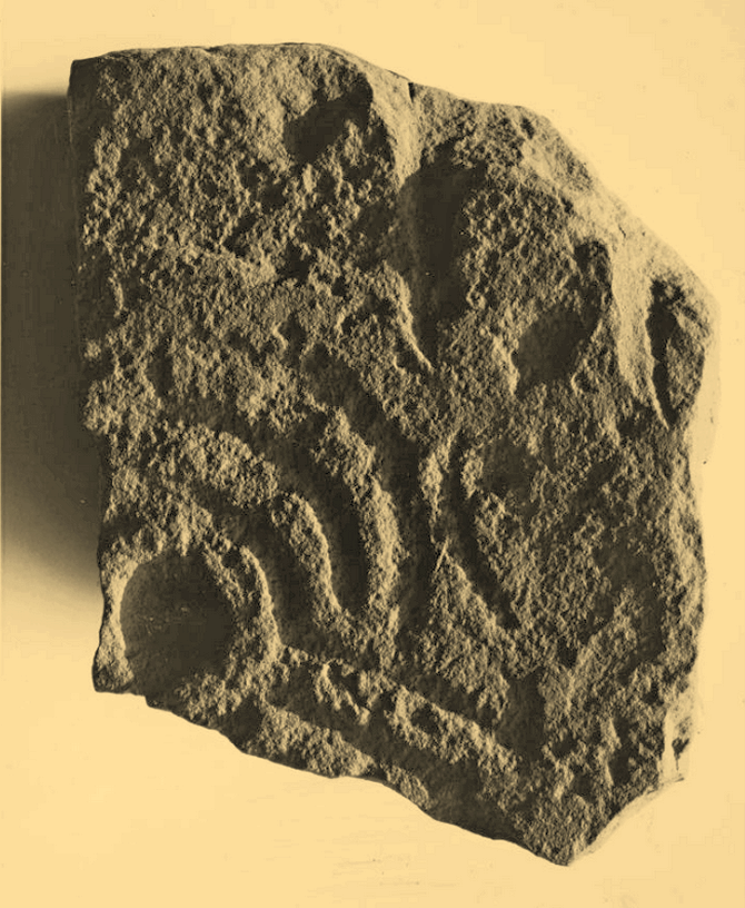
When the Grey Cairn above Balnabroich, Kirkmichael, was explored in the second-half of the 19th century by John Stuart (1865) and a number of local labourers, they found the floor of the tomb had been paved with a number of large boulders. Near its centre, along with finding remains of charred wood, they moved some of the rocks and,
“On turning over the stones a circular disc of stone with a hole in the centre was found, and also a small boulder with a cup on its flat face.”
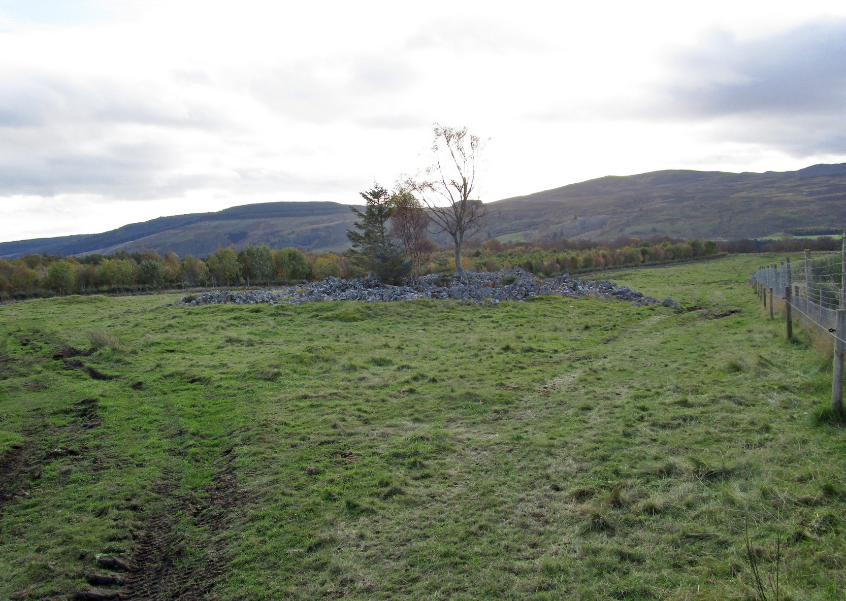
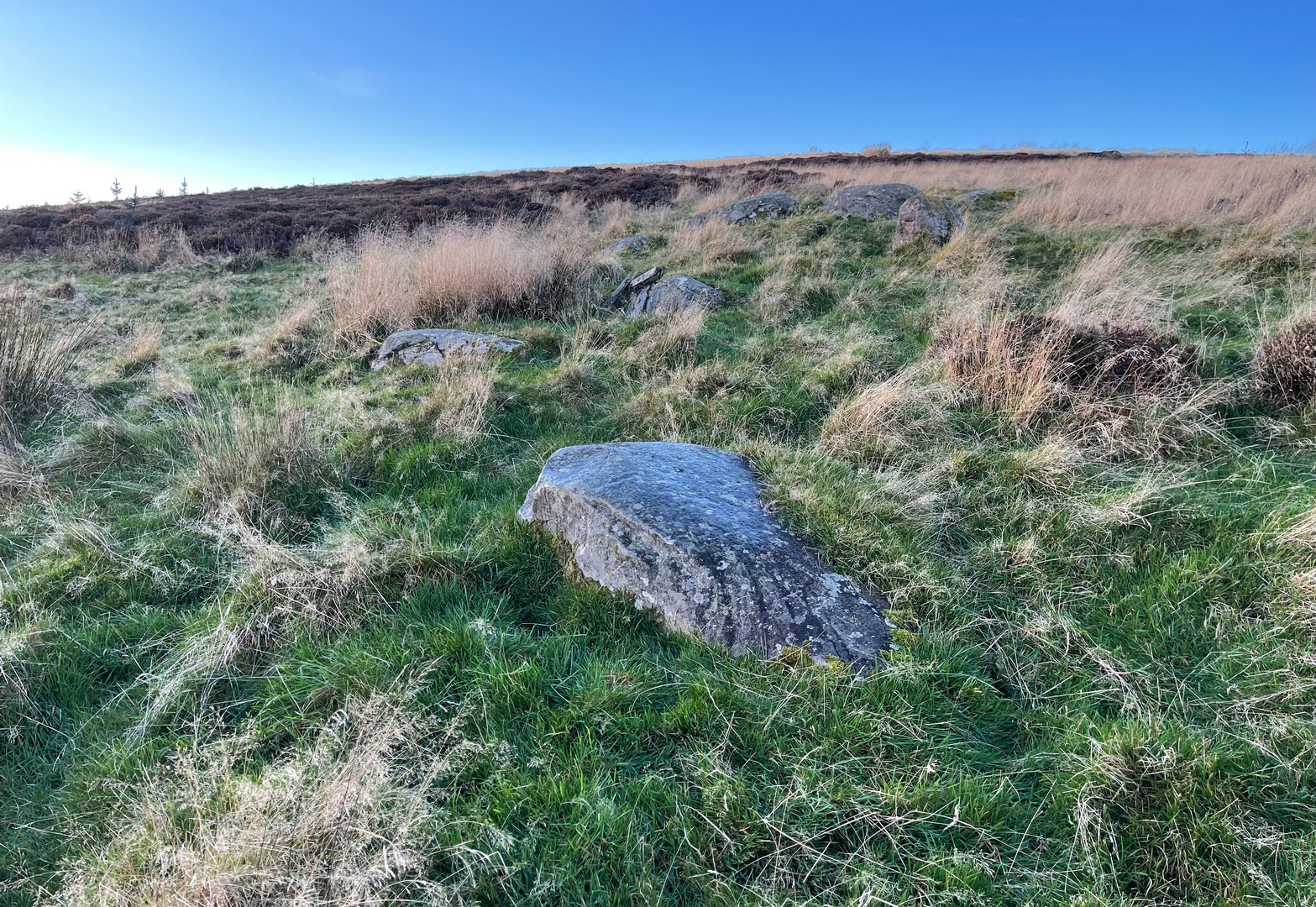
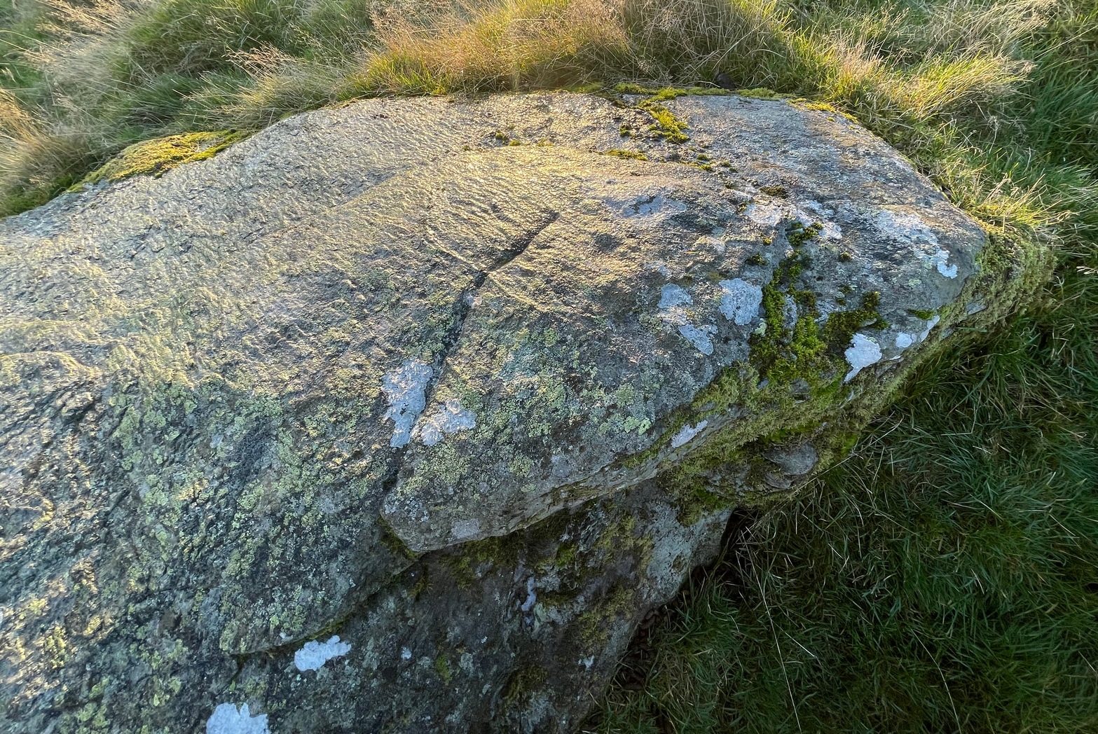
Grey Cairn at sunfall
He made no further remarks about the carving and no intimation that it was removed, so we must presume it is still there, at the botton of the cairn. Any visitors to the site might want to have a look at the massive scatter of surface stones that make up the cairn to see if any further cup-marks exist on them. It’s not uncommon to find them on such giant tombs.
Folklore
A very curious folktale was known of the cairn in the 19th century, whose theme is recognized at numerous other prehistoric sites, but the mythic creature involved here is very much different from the ones we’re used to. Mr Stuart told that,
“The popular belief is that a mermaid is buried beneath it. This mermaid used to throw stones at people who were coming from church at Kirkmichael, and she could only be seen through a hole in the knot of the pine tree. At last she was chased to the hill at Balnabroch on her flight to the waters of Loch Marech, on the other side of the hill, and there killed, when the Grey Cairn was raised over her.”
References:
Royal Commission on the Ancient & Historical Monuments of Scotland, North-East Perth: An Archaeological Landscape, HMSO: Edinburgh 1990.
Stuart, John, “Account of Excavations in Groups of Cairns, Stone Circles and Hut Circles on Balnabroch, Parish of Kirkmichael, Perthshire,” in Proceedings Society Antiquaries, Scotland, volume 6, 1865.
Acknowledgements:Huge thanks for use of the Ordnance Survey map in this site profile, reproduced with the kind permission of the National Library of Scotland.
From near Skipton town centre, at the Cross Keys Inn along Otley Road, go up Short Bank Road all the way to the very top and then into the trees onto the Dales High Way footpath. Walk up for literally ¼-mile (0.4km) and where the path bends and heads ENE, notice here a footpath that takes you over the wall. Once on the other side, the path splits with one heading SE and the other roughly alongside the walling to the SW, which is where you need to go. About 200 yard on, go through the gate into the field and then another 375 yards on you’re into another field (copse of trees in front of you). Just as you’ve gone into this field, walk immediately left, uphill, by the walling for about 100 yards, over the marshy dip, then head into the field where, about 75 yards in, you’ll see some rocks scattered about…
Archaeology & History
Cleland Stone, looking S
In an area that’s had some considerable quarrying done to it, we’re lucky to find that this carving still exists. It was rediscovered by Thomas Cleland (hence its name!) in the summer of 2024. It consists of four distinct cups, with a possible fifth (and maybe more?) on its smooth elongated surface. The cups, as we can see, are quite deep and unmistakable. An incomplete ring seems to be around at least one of the cups; and there seems to be a carved straight line running between another two of them. A simple but distinct design and in a lovely setting gazing cross the Airedale valley from here.
There are very few other carvings in this neck o’ the woods (the Great Laithe Wood carving aint too far away), but the fact that this has been found would suggest that others are probably hiding away in the undergrowth. Check out the Iron Age Horse Close Hill enclosure while you’re up here too.
Acknowledgements: A huge thanks to Thomas Cleland, not only for finding the carving, but also for allowing use of his photos in this site profile.
Cup-and-Ring Stone: OS Grid Reference – NT 200 522
Also Known as:
La Mancha
Archaeology & History
Simpson’s 1867 drawing
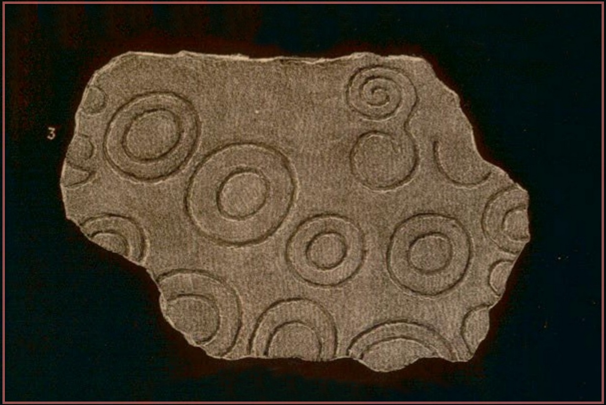
This is what I’ve come to term dyslexic cup-and-rings, due simply to the fact that it’s a cup-and-ring stone carving, but the cup in the centre hasn’t been carved out or pecked away. They’re rare – but for some odd reason, a small cluster of them occurs in this part of lowland Scotland. The Drumelzier carving 13 miles SSW is one; the Carnwath carving 14 miles west is another; 14 miles to the south, the multiple-ringed carving in the Woodend cairn had no defined pivotal cup; and in Childe & Taylor’s (1938) short piece on the Hawthornden petroglyphs near Roslyn (less than 10 miles northeast), they noted—like Simpson & Thawley (1972) years later—the peculiarity of “the complete absence of cups”, akin to Lamancha’s carved rings. (although we should be cautious about the archiac nature of the Hawthornden carvings)
The carving here was first mentioned by one of the great petroglyphic pioneers James Simpson (1866; 1867):
“A broken slab, about two feet square, covered with very rude double rings and a spiral circle, was found by Mr Mackintosh, at La Mancha, in Peeblesshire, in digging in a bank of gravel. There were some other large stones near it; none of them marked. Possibly this stone, therefore, is sepulchral in its character.”
Lamancha carving (G. & A. Ritchie, 1972 )
Eoin MacWhite (1946) was somewhat sceptical of Simpson’s “sepulchral” association, simply due to there being no account of a burial here. But in Simpson & Thawley’s (1972) survey of passage grave art, they thought the Lamancha carving was from “a possible cist slab.” We might never know for sure one way or the other.
The carving ended up living in Edinburgh’s National Museum where it should, hopefully, still be on display. As a result of this, it received the attention of the Royal Commission doods who gave a good description of the design in their Peeblesshire Inventory (1967). They state that it
“is irregular in shape and has maximum dimensions of 2ft 6in by 1ft 10in; it averages 4in in thickness. The markings, which have all been formed by the pecking technique, occur mainly on one face, the most common symbol being single or double rings. There are four complete double-ring symbols, in which the outer rings measure from 5in to 7in in diameter, and the inner rings from 2in to 4in. Round the margin of the face there are the broken arcs of five more double-ring symbols and of five single rings and one small V -shaped figure. As well as the ring markings there is a double-spiral, each lobe of which measures about 4in in diameter. In one lobe the spiral has two and a half turns and in the other only one turn. In addition, in a space which is otherwise free of markings, there is an area, about 4in square, heavily pitted with punch-marks measuring one-eighth of an inch across and one-sixteenth of an inch in depth. A remarkable feature of the stone is that three incomplete single ring symbols have been made on one edge. They have been formed by the same technique and measure 3in across; as in all the other symbols, the grooves themselves measure about half an inch in width and about one-eighth of an inch in depth.”
McWhite, Eoin, 1946 “A New View on Irish Bronze Age Rock-Scriblings”, in Journal Royal Society Antiquaries, Ireland, vol. 76, 1946.
Morris, Ronald W.B., “The Cup-and-Ring Marks and Similar Sculptures of South-West Scotland,” in Transactions of the Ancient Monuments Society, volume 14, 1967.
Morris, Ronald W.B., “The Cup-and-Ring and Similar Early Sculptures of Scotland; Part 2 – The Rest of Scotland except Kintyre,” in Transactions of the Ancient Monuments Society, volume 16, 1969.
Morris, Ronald W.B., The Prehistoric Rock Art of Southern Scotland, BAR: Oxford 1981.
Ritchie, Graham & Anna, Edinburgh and South-East Scotland, Heinnemann: London 1972.
Royal Commission on the Ancient & Historical Monuments, Scotland, Peeblesshire – volume 1, Aberdeen University Press 1967.
Simpson, D.D.A. & Thawley, J.E., “Single Grave Art in Britain,” in Scottish Archaeological Forum, no.4, 1972.
Simpson, J.Y., “On Ancient Sculpturings of Cups and Concentric Rings,” in Proceedings of the Society of Antiquaries, Scotland, volume 6, 1866.
Simpson, James, Archaic Sculpturings of Cups, Circles, etc., Upon Stones and Rocks in Scotland, England and other Countries, Edmonston & Douglas: Edinburgh 1867.
Cup-and-Ring Stone (removed): OS Grid Reference – NT 1872 4072
Archaeology & History
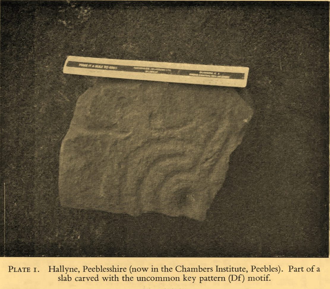
Included in the standard catalogues by Ronald Morris (1967; 1969), this carving was brought to light fortuitously by the local farmer who, thankfully, recognized its archaeological importance. Etched into a small flat broken block of stone, he noticed a cup-marking and the remains of a triple-ring around it, with grooves running out from the central cup. It was described in detail by the Royal Commission (1967) lads in their county survey where they told:
R.W.B. Morris’ 1967 photo
Hallyne carving in Peebles Museum
“During the excavations at the Roman fort at Lyne…in June 1959, a stone bearing cup-and-ring markings was found lying beside the fence that crosses the North Annexe. According to local information it was found while ploughing in the field on the NE side of the fence. It is a sandstone block, measuring 1ft 5in by one foot, and with an average thickness of 8in. It is clearly a mere fragment of what must have been a larger slab, but it is impossible to estimate its original dimensions. The markings consist of a single well-formed cup, 2in in diameter and three-quarters of an inch in depth, now partly surrounded by the broken arcs of three rings, which, if complete, would measures about 4in, 7in and 10in in diameter respectively. The rings are all half an inch in width and one eighth of an inch in depth. From the innermost ring two radial grooves, set one inch apart, extend outwards for a maximum distance of 4in. They interrupt the two outer rings, which stop short on either side of them, leaving a gap of about half an inch. The grooves are slightly narrower and shallower than the rings. The whole symbol has been formed by the pecking technique and punchmarks are still remarkably fresh. Outside the outermost ring there is a very shallow depression, one inch in diameter, which may be another cup-mark; in addition there are several recent scars caused by the plough.”
It was moved to the museum in Peebles shortly after being found and remains there to this day, apparently. I’ve not seen it.
References:
Morris, Ronald W.B., “The Cup-and-Ring Marks and Similar Sculptures of South-West Scotland,” in Transactions of the Ancient Monuments Society, volume 14, 1967.
Morris, Ronald W.B., “The Cup-and-Ring and Similar Early Sculptures of Scotland; Part 2 – The Rest of Scotland except Kintyre,” in Transactions of the Ancient Monuments Society, volume 16, 1969.
Morris, Ronald W.B., The Prehistoric Rock Art of Southern Scotland, BAR: Oxford 1981.
Royal Commission on the Ancient & Historical Monuments of Scotland, Peeblesshire – volume 1, HMSO: Edinburgh 1967.
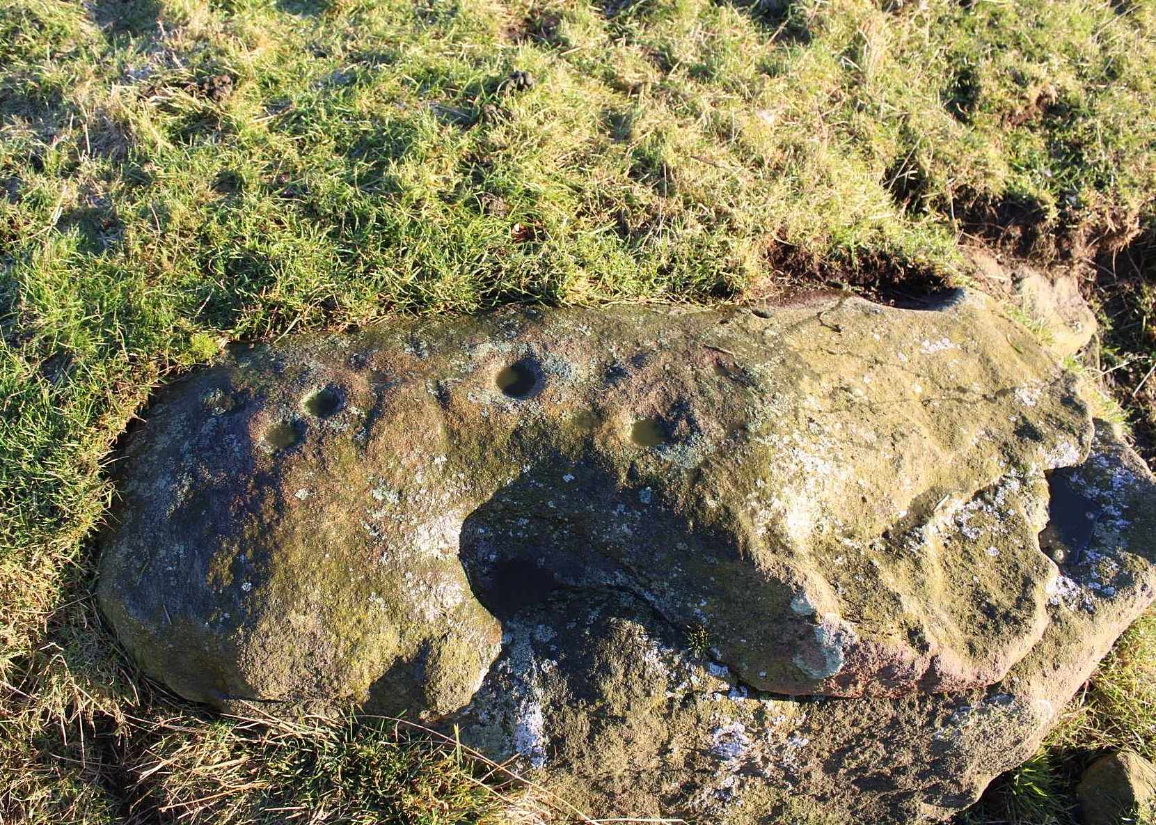
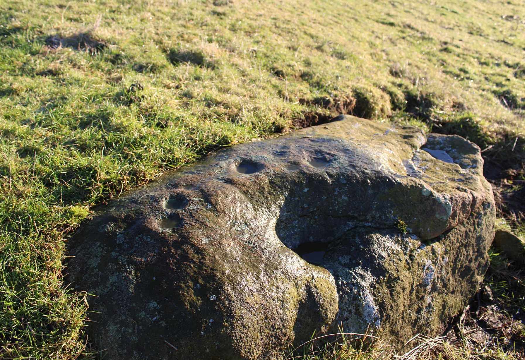
If you can make your way to the Stroness (2) carving, then walk down the slope for less than 50 yards past quite a few other earthfast stones, you’ll eventually run into the stone shown here in the photos. You’ll find it easily enough.
Archaeology & History
This carving was found when I was heading down the hillside to meet up with my antiquarian colleague 500 yards lower down. The sun was just setting, so visibility wasn’t good, but as I rushed from stone to stone feeling each one in the hope of finding a carving, this one gave my fingers that distinct feedback of a cup-marking; then another; and what seemed like another. I had a small amount of water left in a bottle and quickly sprayed it over the surface of the stone and saw that there were indeed a number of cups on it. Two or three certainly – but possibly as many as five. I laid on the wet ground and looked across its even surface from several angles and caught what seemed to be a very faint semi-circle around one of the cups. But I wasn’t sure it was real. However, on a number of quick photos I took, several of them do appear to show such an arc around one of the cups. But I’m very cautious about it. Only when we (or you) go back up and have a look at it in good light will we be able to affirm or discount it.
One additional feature that needs mentioning is a small low arc of walling just above this stone. It’s man-made, it’s very old, but I couldn’t work out what it might be: hut circle, cairn (there’s one further up the hill), enclosure walling. I’m not sure, but it needs to be looked at when we have a full day.
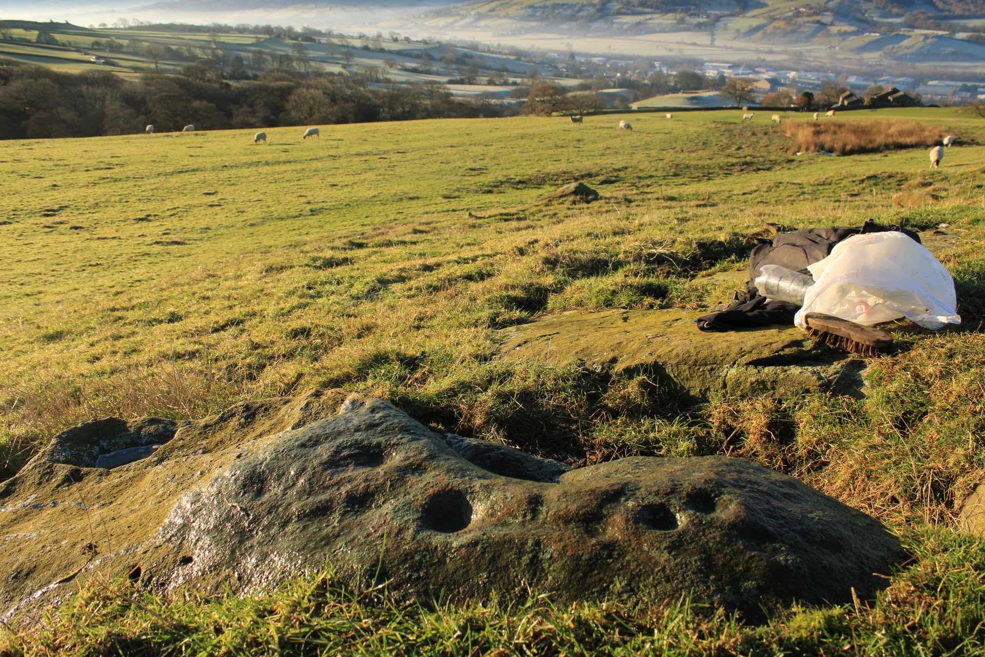
The minor road that runs roughly north-south between the hamlets of Fowlis Wester and Buchanty is probably your best bet. Nearly 2 miles north of the village up the tiny winding lane, where the moorland at the roadside finishes and the fields begin – is where to take the track, left, up onto the hillside. But after just 75 yards, go left over the rickety-gate and follow the walling until your reach the burn. Follow this up all the way to its source (it’s boggy as hell) and, once you’re there, walk due north for 250 yards until you reach a cluster of rocks. Look around!
Archaeology & History
It’s a long way to come to see such a simplistic design —but for the real petroglyph researchers among you, it’s worth it the trek. It’s had scant attention. George Currie (2004) seems to have been the only person to mention this stone, giving the standard bland description typifying archaeology. He wrote:
“SE-facing slope, 1.2m long pointed rock aligned E-W; three shallow cups, 30-40 x 6-10mm.”
Inspiring stuff, ey?! Anyhow… As usual, there’s more to it than that. If we assume that the carving described above is the same one I visited yesterday (Mr Currie’s grid-ref is slightly different), even despite the poor daylight, it was obvious there was more than three cup-marks on this.
Lower cups & upper cups
Cups on top
When I got to this stone, the evening sun was literally touching the horizon and so the light cutting across half the rock highlighted very little indeed. I was rushing, trying to fondle and see as much as I could before the darkening sky clouded everything, and as I almost frenetically sprayed showers of water across its surface, the two or three cups that I could see near the crown of the stone suddenly doubled in number. Two cups along one edge became three; whilst the sloping surface above these that had one cup suddenly seemed to have a companion. On the highest part of this gently sloping stone, the form of one of the two distinct cup-marks that first caught my eye seemed to slowly morph into one of the carved “footprint” designs, akin to those clustered on the Ardoch (2) carving 1½ miles south-west of here. However, this element needs looking at again, as it may have been a curious playful trick between stone and light showing me something that wasn’t there! Things like that happen with stones.
Altogether there are at least six cup-marks on here, but perhaps as many as eight. Obviously, if we (or you) visit the site when the light is much better, an even larger design might emerge from this old rock.
I spent perhaps just five minutes here, before heading back down to meet my companion 500 yards below in the midst of the boggy moorland. Usually a carving gets my fondles for a an hour or two, but conditions weren’t good for us to form a healthy relationship. And so, as I headed downhill, another unrecorded cup-marked stone appeared beneath my rushing feet (Stroness [3] carving)— and I spoke with that for only a couple of minutes. We need to come back up here and zigzag to find other companions that lay sleeping, forgotten for countless centuries…
References:
Currie, George, ‘Buchanty Hill (Fowlis Wester parish): Cup-marked Rocks’, in Discovery & Excavation Scotland, volume 5, 2004.
Cup-Marked Stone (destroyed): OS Grid Reference – SE 152 393
Also Known as:
Carving no.195
Archaeology & History
A basic cup-marked stone could once be seen up near the top of the slope behind the Bay Horse pub as you’re heading up to Baildon village. The site would seem to have been destroyed following the demolition of buildings thereby. A photograph of the carving was taken and it was described, albeit briefly, by Sidney Jackson (1961), who told:
“A small boulder with two cups in it was found at the junction of a narrow bye road leading to 30 Lane Ends, Baildon, with the road which runs behind the Bay Horse Inn, on 12 April (1961), by Mr Alan E. Rowe, 10 Beaufort Grove, Bolton, Bradford and a photograph of it was taken for the Museum Reference Collection.”
Years back I contacted the Bradford Museum about this photo and they were about as helpful as a zionist in Palestine! – i.e., I never got to see it. It would be good if someone could locate the image.
References:
Boughey, Keith & Vickerman, E.A., Prehistoric Rock Art of the West Riding, WYAS: Wakefield 2003.
Jackson, Sidney, “Cup-marked Boulders, Baildon Finds,” in Cartwright Hall Archaeology Group Bulletin, volume 6, no. 6, 1961.
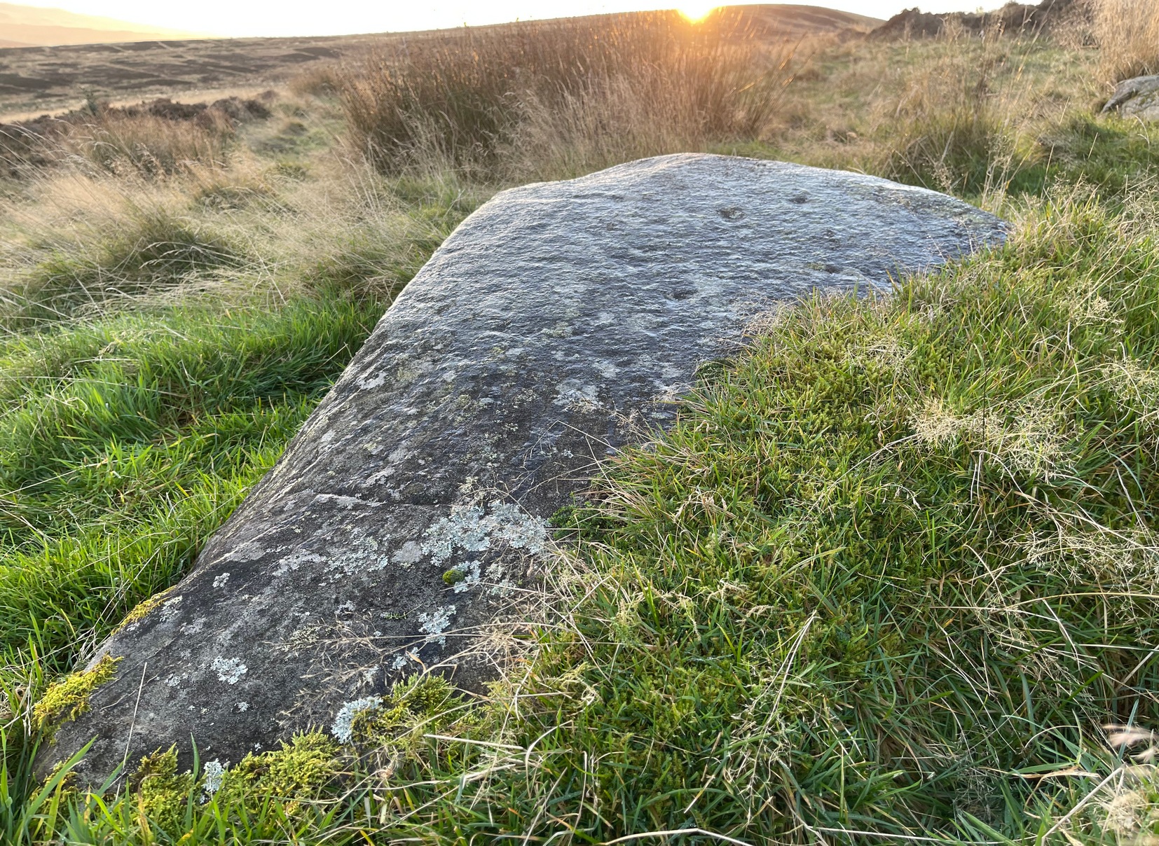
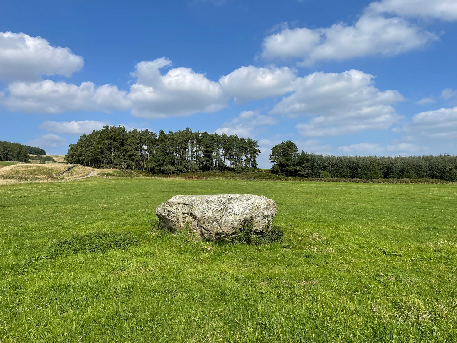
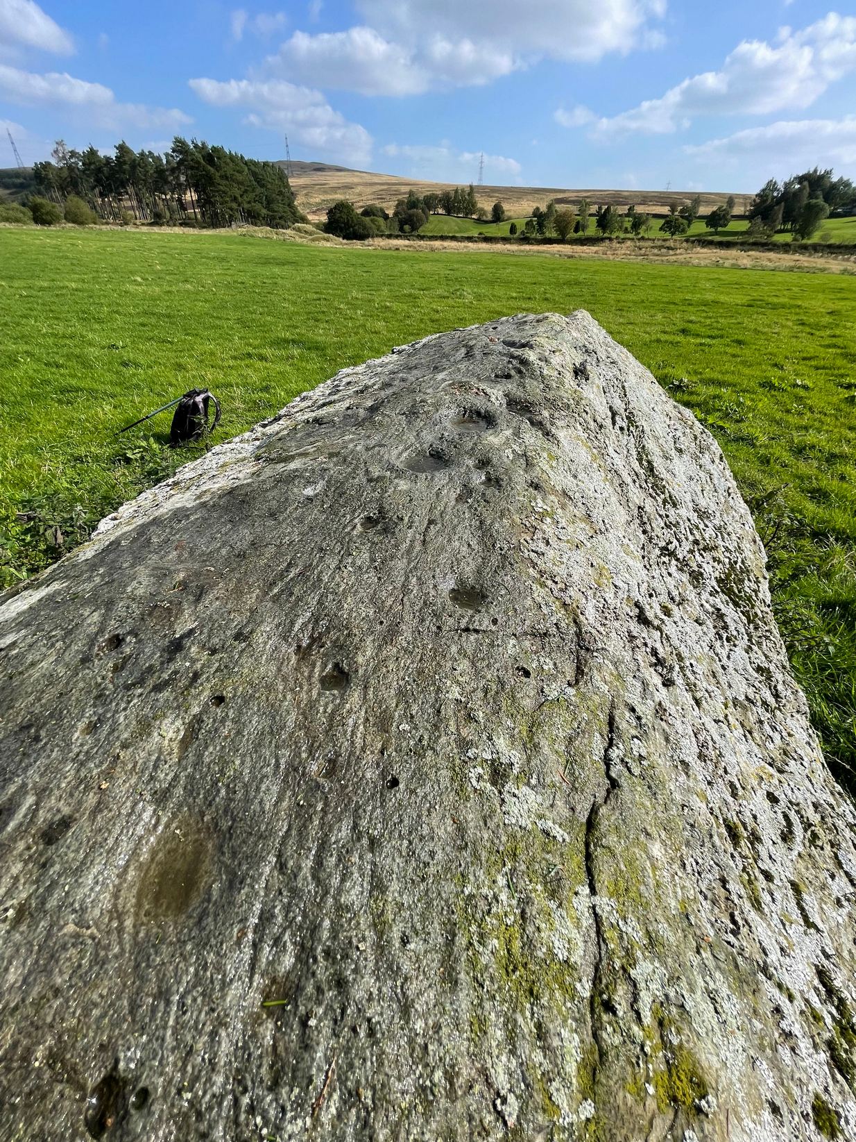
Take the A85 road east out of Crieff and after roughly 2 miles at Gilmerton, turn left up the A822 Dunkeld road. Go along here for nearly 2½ miles, where you’ll reach the Foulford golf course on the right-hand side of the road. Directly opposite the entrance into the golf course, a dirt-track leads you into the fields where, laying alone and standing out like a sore thumb about 300 yards away, you’ll see a large rounded boulder sitting there minding it’s own business. You can see it quite clearly from the roadside. Nice n’ easy.
Archaeology & History
For such a large conspicuous stone, you’d think there’d be quite a lot written about it as well as hope for a good ornate design—but alas!, both hopeful expectations are lacking. Although, as usual, there’s more to it than is described in the official records—although not much more….
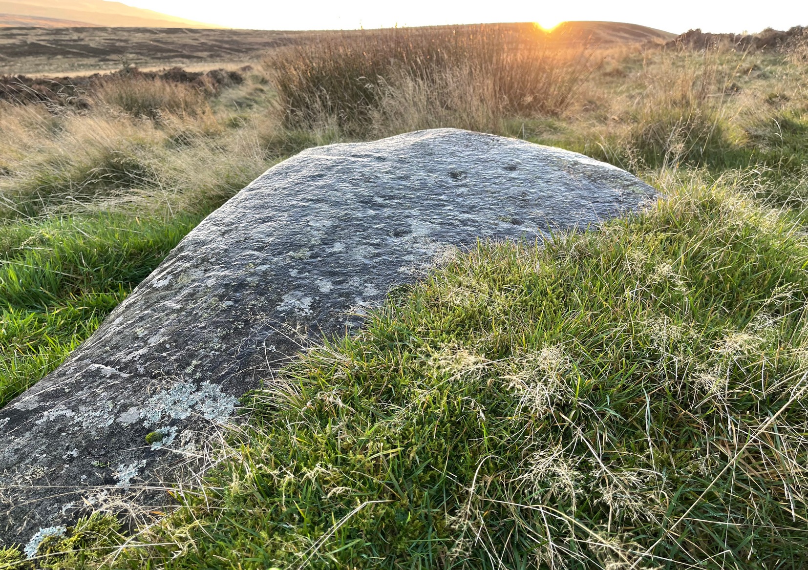
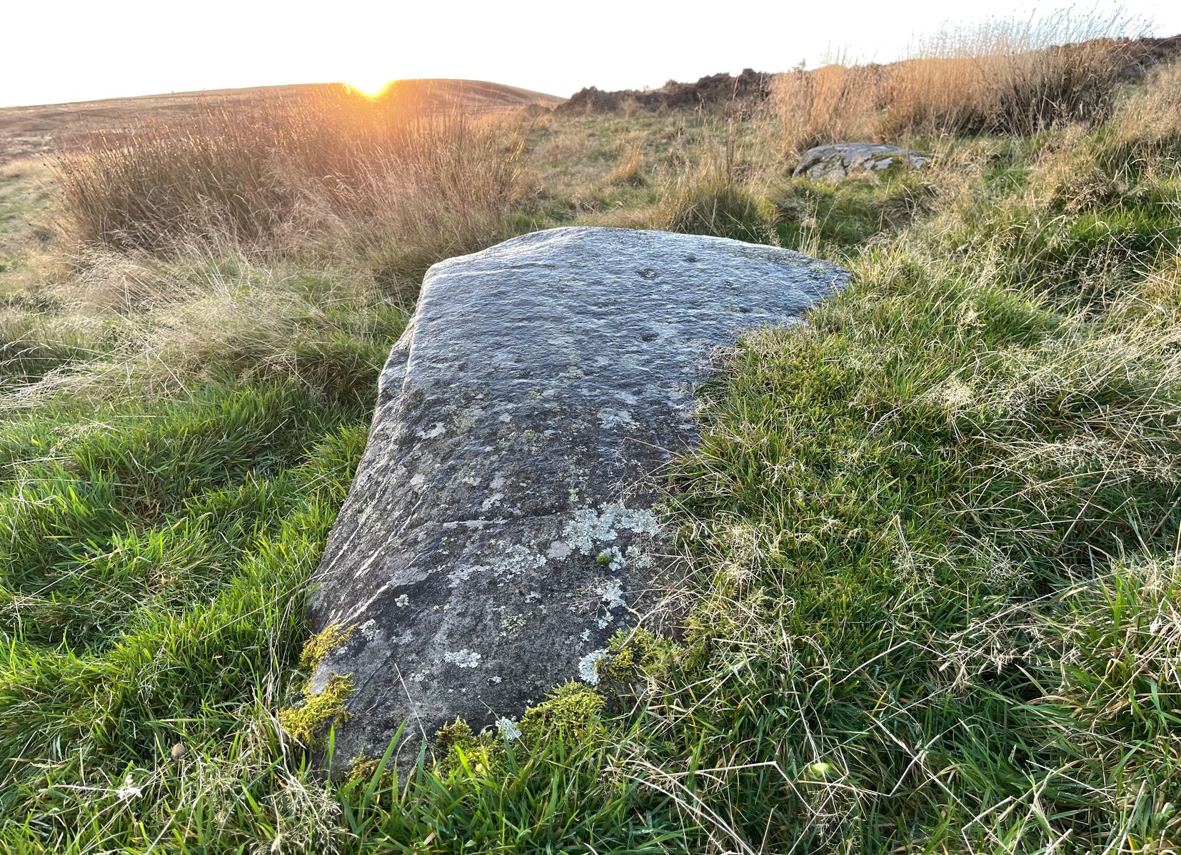
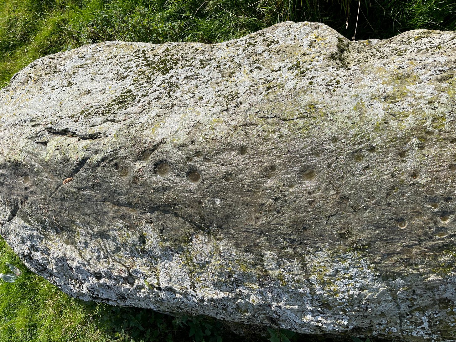
Long stone & its cupmarks
Cups along the spine
As you walk towards it, it seems as if a rounded earthfast boulder is in front of you, but once you reach it you realise that it’s nothing of the sort. Indeed, the more you looked at the stone, the more it seems as if it might have stood upright not too many centuries ago; the prevalence of other standing stones in the area being well known. But, along the spine of this long stone, a number of cup-marks speak out to you: at least seven of them, perhaps eight. There are a number of smaller “cups” roughly along the same length of stone, but these are Nature’s handiwork; but, it looks as if one or two of the man-made cups might have started their lives as Nature’s indentations and been worked into the symbols that still remain to this day.
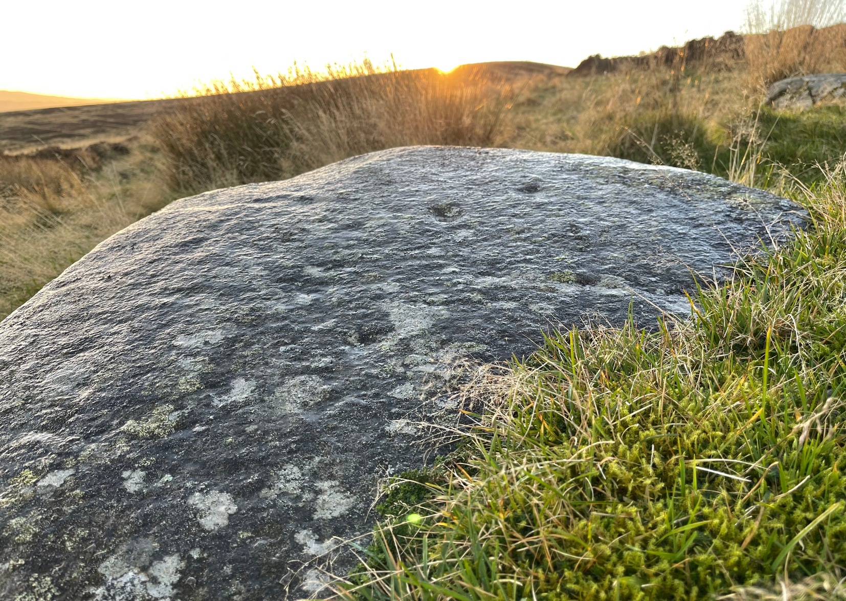
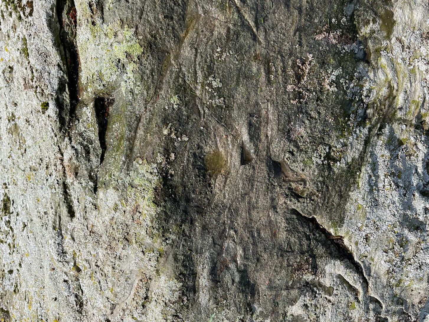
Faint ring around a cup
Nose of stone, looking E
The official records tell us of the cup-marks, but says nothing of the faint but distinct rings around two or three of the cups. The most notable one, albeit faint, is near the southeastern part of the stone, where the ring seems to be an artistic partnership of Nature and man. You can make it out in the photo, albeit not too clearly. Nearer to the middle of the stone at least one of the cups has a semi-circle around it and, just to the side of it, a natural crack in the stone has been enhanced and carved into a short line. On the whole, it’s not a visually impressive carving and the design is troublesome to see if the lighting isn’t right (as usual), but is worth having a look at if you’re in the area. Very little’s been written about it apart from brief notes in the regional megalithic surveys of both Finlayson (2010) and Watson (2006).
References:
Finlayson, Andrew, The Stones of Strathearn, One Tree Island: Comrie 2010.
Watson, David, A Simple Introduction to the Stone Circles and Standing Stones of Perthshire, Photoprint 2006.
Acknowledgements:Huge thanks for use of the Ordnance Survey map in this site profile, reproduced with the kind permission of the National Library of Scotland.
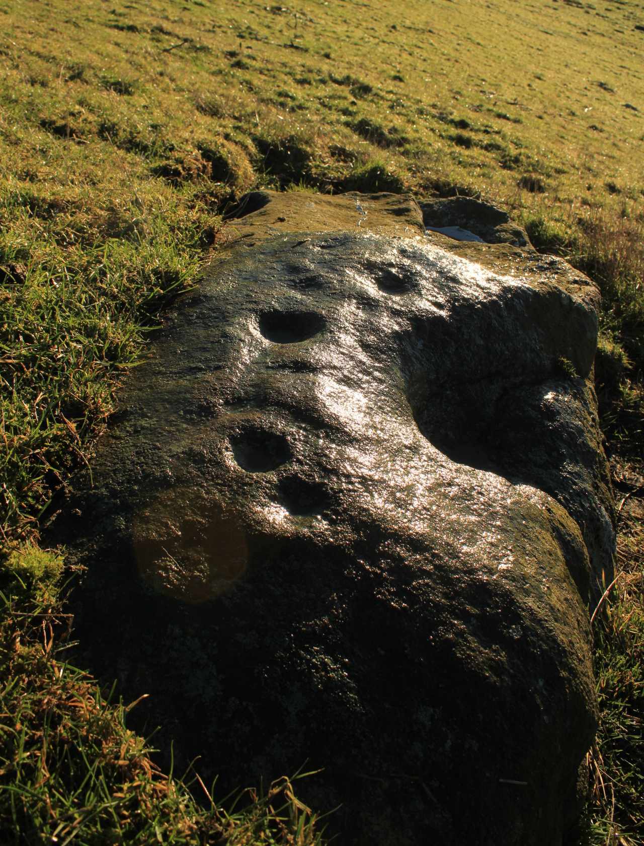
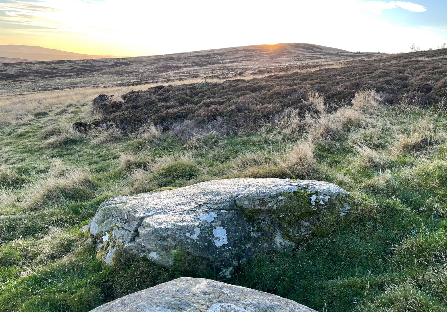
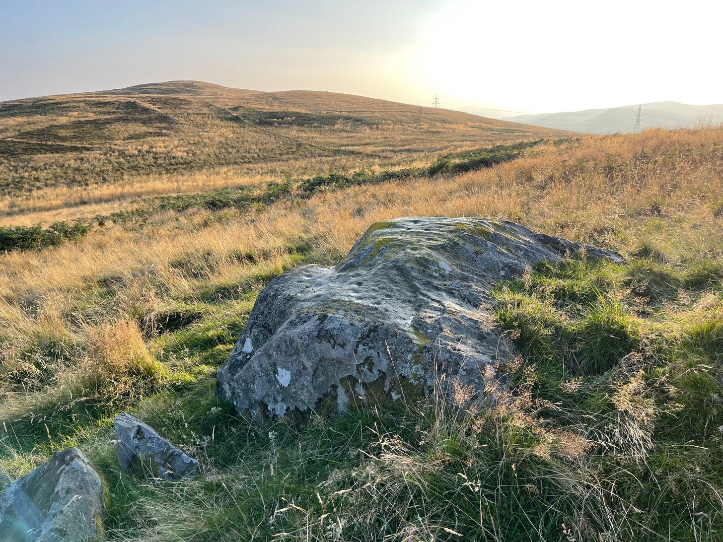
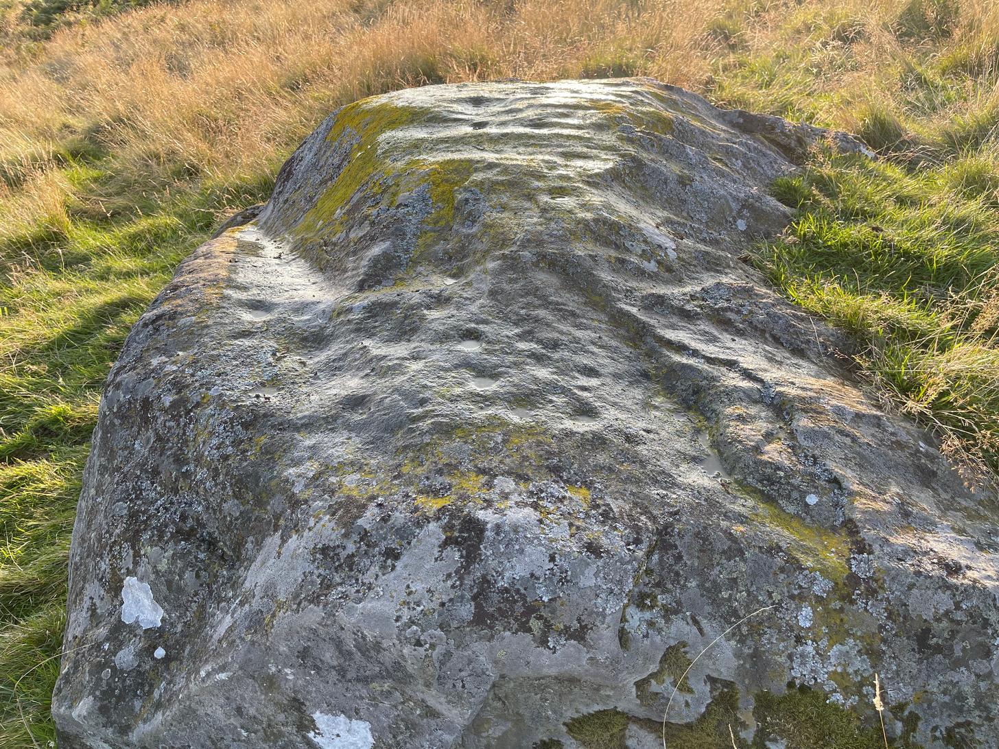
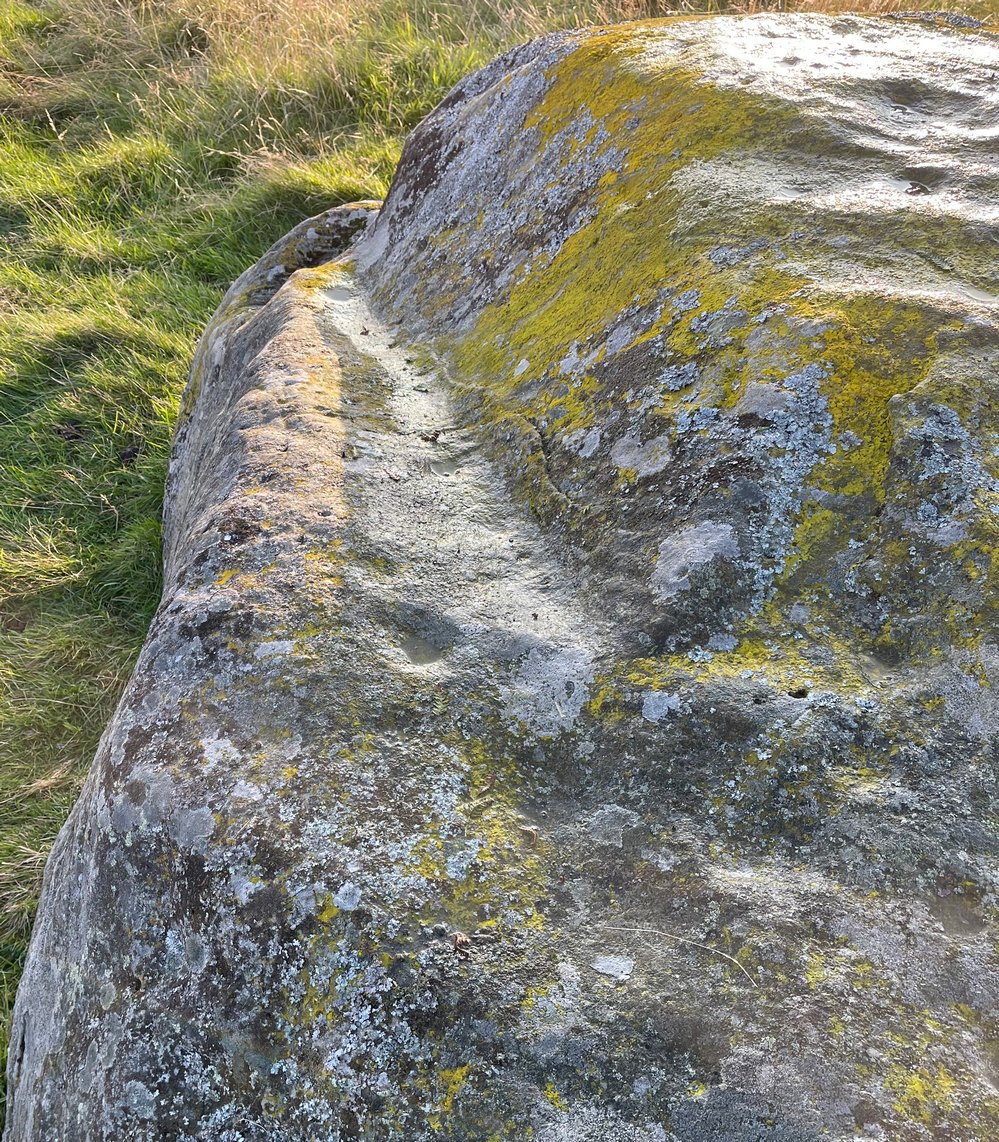
Take the same direction as if you’re visiting the Ardoch (2) carving, starting from the Foulford golf course on the A822, roughly halfway between Gilmerton and the entrance to the Sma’ Glen. From here, take the track eastwards into the hills and literally ¾-mile along you reach the pylon; keep going along the same track for another 200 yards and on your left watch out for the track-cum-footpath going up the slope past Ardoch (2), onto the hilltop, then through the gate and down the path northeast for about ⅔-mile until you reach the burn. Keep going uphill for 80 yards and through the cronky gate, head 70 yards to your left to the large single rounded boulder.
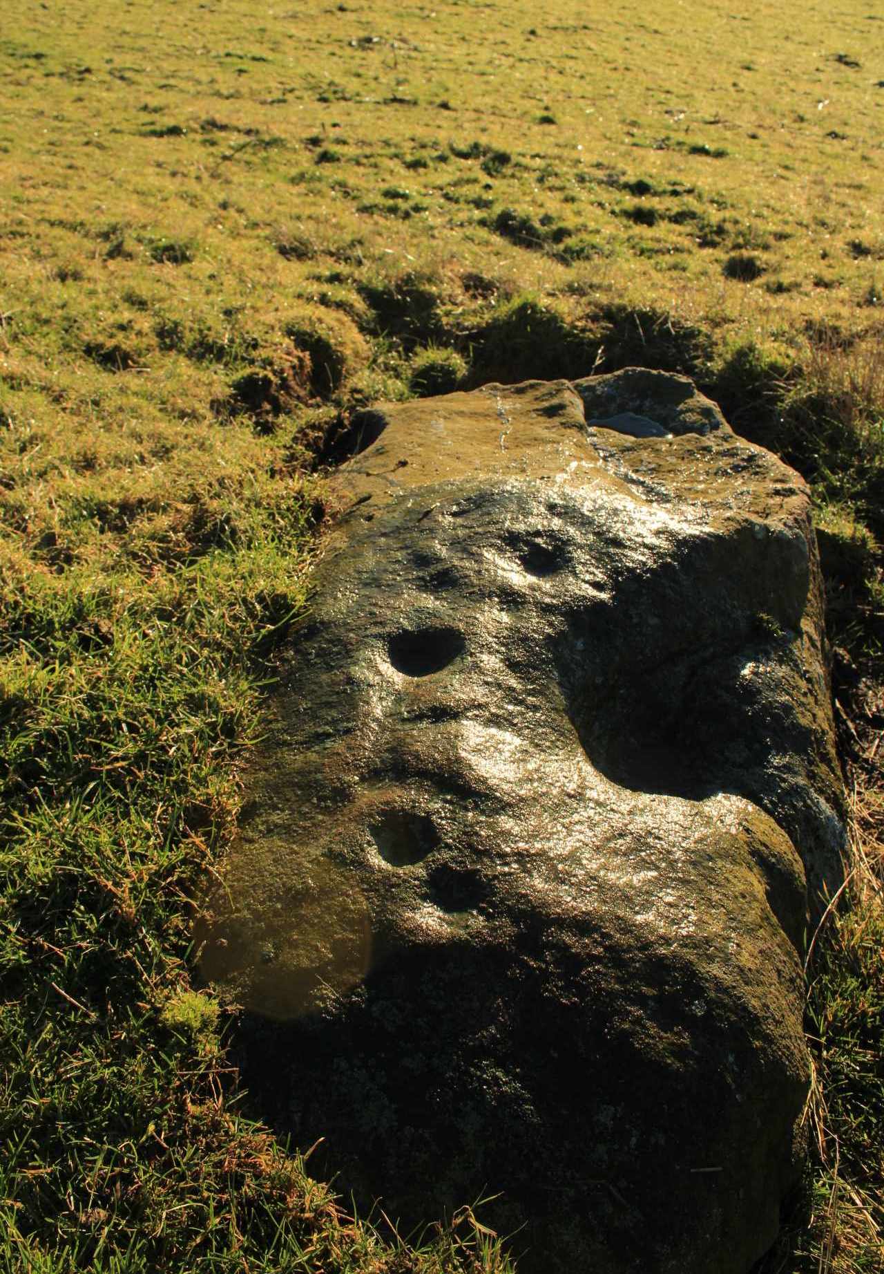
Archaeology & History
Main scatter of cups
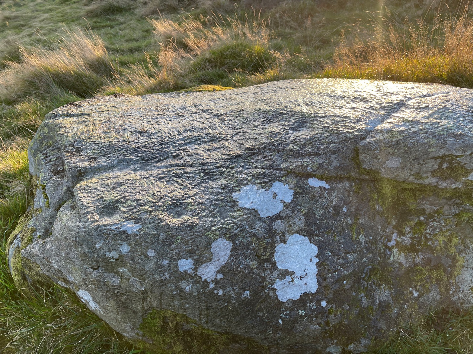
One of several petroglyphs in the area, this is the most notable in terms of its size. It rests just below the two Stroness hut circles which sit on the small level piece of ground nearly 100 yards further up the slope. A considerable scatter of cup-marks cover much of the upper surface of the boulder, some faint, some not so faint, with a number of them painted in a slight cover of lichens at the topmost section of the rock. The carving was first described somewhat blandly by George Currie (2004), who simply wrote:
“Large boulder, 2 x 2m, just W of hut circles; 16+ cups, 40–50 x 14–20mm.”
Faint line near the edge
Cups among the lichens
It’s actually south of the hut circles; and there are certainly more than sixteen cup-marks, as the photos here indicate. At the time of my visit here recently, the sun was falling and was just below the level that permitted a perfect highlighting of the cup-marks, but there seemed to be at least 25 of them, scattered in no particular order over much of its upper surface. One curiosity that seemed apparent was a long carved line running along a long slender edge along on the southern side of the stone, from a large cup-mark down to near the southwestern edge, meeting another smaller cupmark. I not 100% certain that it’s actually been carved and it may just be one of Nature’s scratches along the rock, but it does seem to have that “man-made” stamp on it. Another visit in differing light will show us one way or the other.
References:
Currie, George, ‘Buchanty Hill (Fowlis Wester parish): Cup-marked Rocks’, in Discovery & Excavation Scotland, volume 5, 2004.
Ardoch (2) carving, with Milquhanzie hillfort behind
We took the long route to get here, via Fowlis Wester village, up to the car-park near the standing stones, then walk for 1¾ miles along the track: past the stones, veering right to go downhill then uphill, past the Ardoch (1) petroglyph and bearing right at the next split in the track, then right again at the next split. Then, crossing a small burn and curving round the next bend, keep your eyes peeled for the track-cum-footpath that reaches uphill on your right (NE). A shorter route is via the Foulford golf course (found along the A822 roughly halfway between Gilmerton and the entrance to the Sma’ Glen): take the track from there, eastwards into the hills, and literally ¾-mile along you reach the pylon; keep walking along the track for another 200 yards and on your left watch out for the same track-cum-footpath. Walk up there for about 400 yards and, 35 yards to the right of the fence, you’ll see a large flat stone.
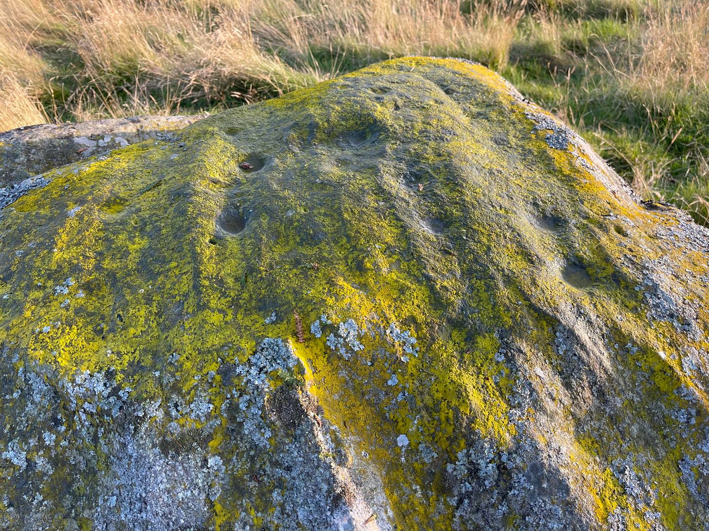
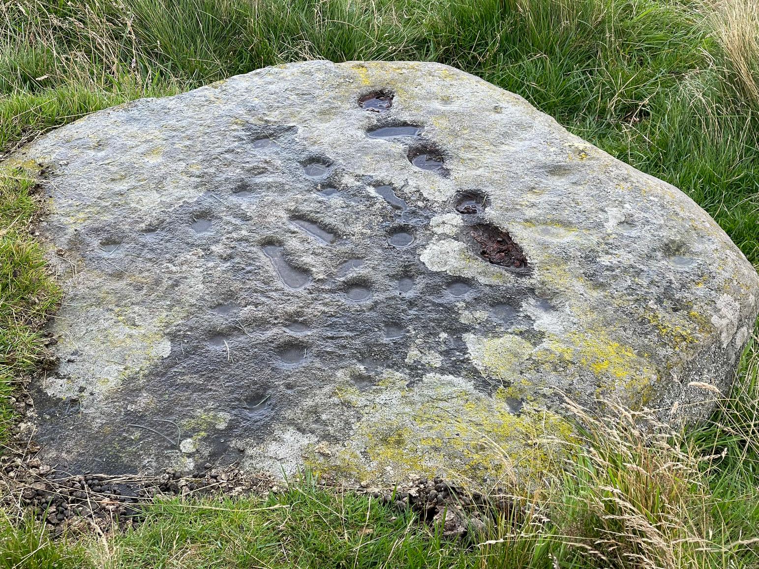
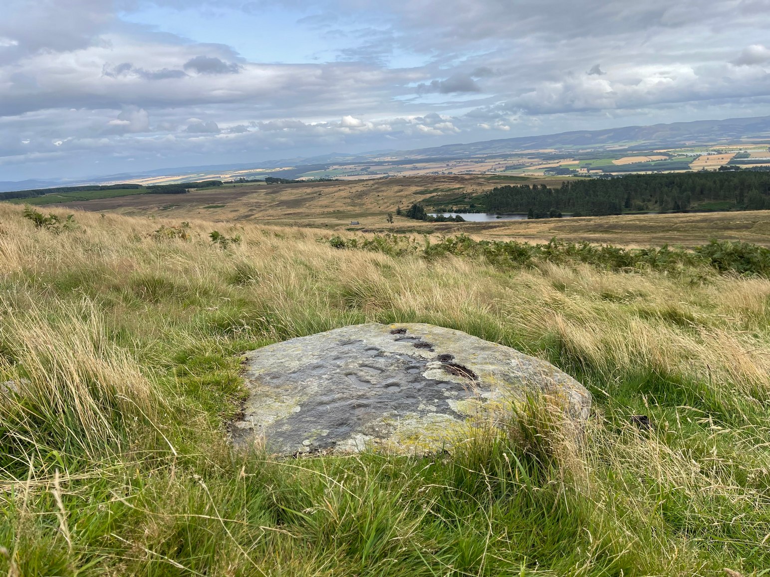
Archaeology & History
This is a most curious design, sitting way up near the top of this unnamed hill on its western face. It’s curious as there are number of odd elongated cup-marks which, to me at least, should be described as footprints. We find such designs on a few carvings (such as the one at Dunadd, and St. Columba’s Stone, etc), but they’re pretty rare. The best can be found on the Cochno Stone a few miles north of Glasgow, with additional toes on the design… but that’s for another site profile – and an essay, perhaps, should I ever get round to writing it! Anyhow…
It was first described, albeit briefly, by a Mr Comrie in 1972, who told us that,
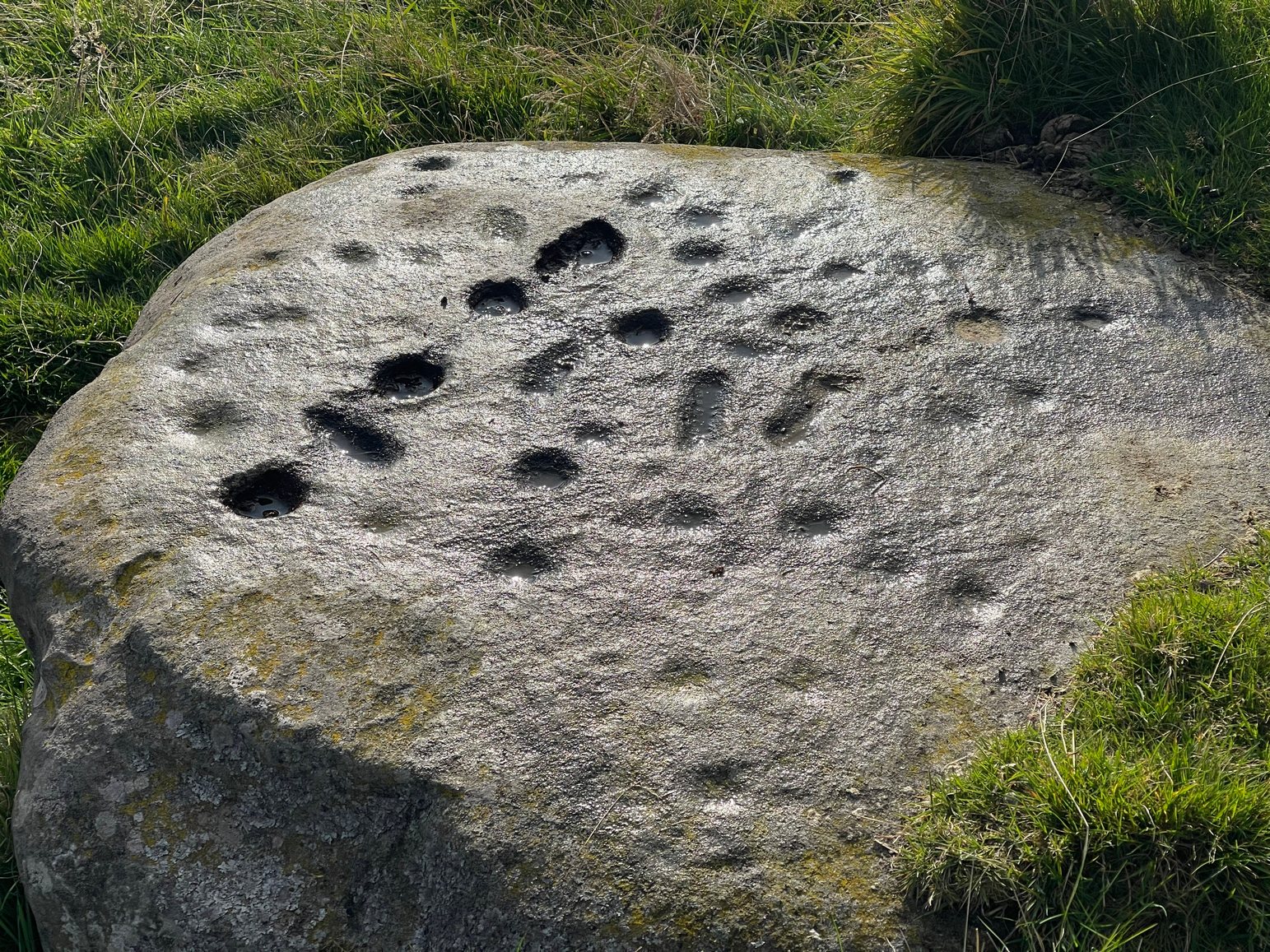
“On a south-west facing slope of Buchanty Hill at 950ft is a boulder measuring 1.60m x 1.40m with 22 cups and 11 dumb-bells, 6 of which are distorted by a fault of quartz in the stone.”
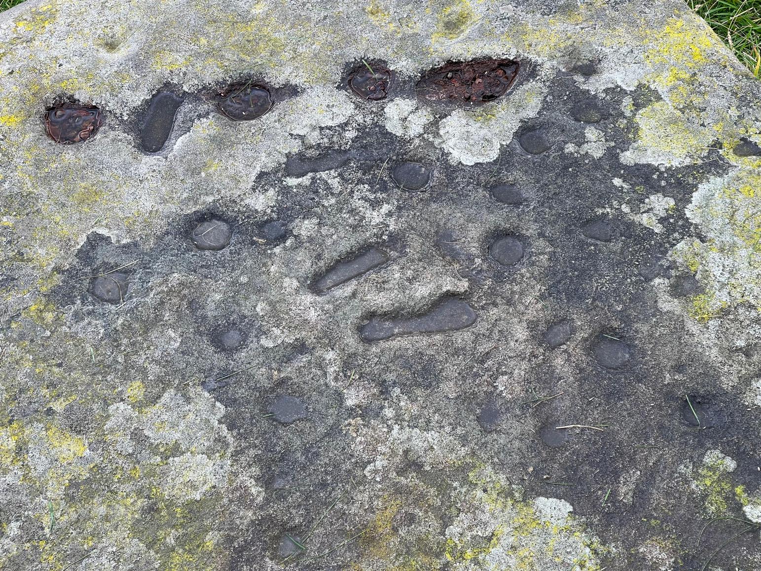
Central “footprints”
“Footprints” & cup-marks
But his description of what he saw as eleven “dumb-bells” is somewhat extravagant. Six, perhaps seven would seem the more probable. I was hoping to find that the Scottish Rock Art Project doods might have spent some of their million quid in doing a computer enhancement of this carving in order to confirm it one way or the other, but this was one of hundreds that they never looked at. Very poor… (and they only described two so-called dumb-bells here!) The only other mention I’ve found of the place is in Finlayson’s (2010) fine survey of local megaliths, but only in passing.
The dumb-bells or “footprints” on this carving are small: fairy footprints, one might say. The main ones are seen near the middle of the stone on its flat smooth surface. Another—perhaps two—occur along a curious geological cut that runs in a straight line, north-south (roughly) over the rock. This curious line has a series of deeply cut elements, mainly cup-marks, which give the impression of being enhanced or worked upon in much more recent centuries, looking almost as if they possessed some utilitarian function. They’re most odd and are certainly much younger than the very worn cup-marks that are scattered across the stone in no particular order. One of them seems to have a very faint ring around it. You can just make it out in one of the photos.
Looking southeast
A nice close-up
So we’re looking at a multi-period carving done (probably) over several centuries. Some of the cup-marks are barely visible unless the light is just right. On my first visit here, the day was grey and overcast and some elements of the design were all but invisible; but on my second visit, on a beautiful evening, when wetting the rock, it shone out in all its splendour…. Well – as good as could be expected considering it may be five thousand years old! But the footprints are the stand-out features of the design.
In a lengthy essay on this motif that’s found on numerous European petroglyphs, Miroslav Verner (1973) points out several traditional and theoretical meanings ascribed to the symbol, which may be relevant to the stone here. The footprints may mark the rock as a pilgrimage site; or a representation of the location of a theophany, or genius loci. In some places it can be a signature of the so-called artist; or a symbol of victory; and even a symbol which possesses the power to cure fevers and other ailments. This latter tradition was known to have been practiced at the mightily impressive Blarnaboard (3) carving near Aberfoyle.
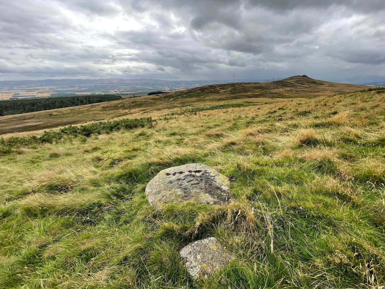
Another important feature of this carving its position in the landscape: more than a thousand feet above sea level, you sit here and the vista ahead of you reaches far far away into the distance from east to south to west. The skies above and around it are open and seemingly endless from here. It’s impressive and, most likely, these attributes are mythically significant to its meaning. Have a look at the place: take a day out and sit here for a while and get your own impression of the place. You’ll like it…