Cup-Marked Stone (lost): OS Grid Reference – NO 0617 2328
Archaeology & History
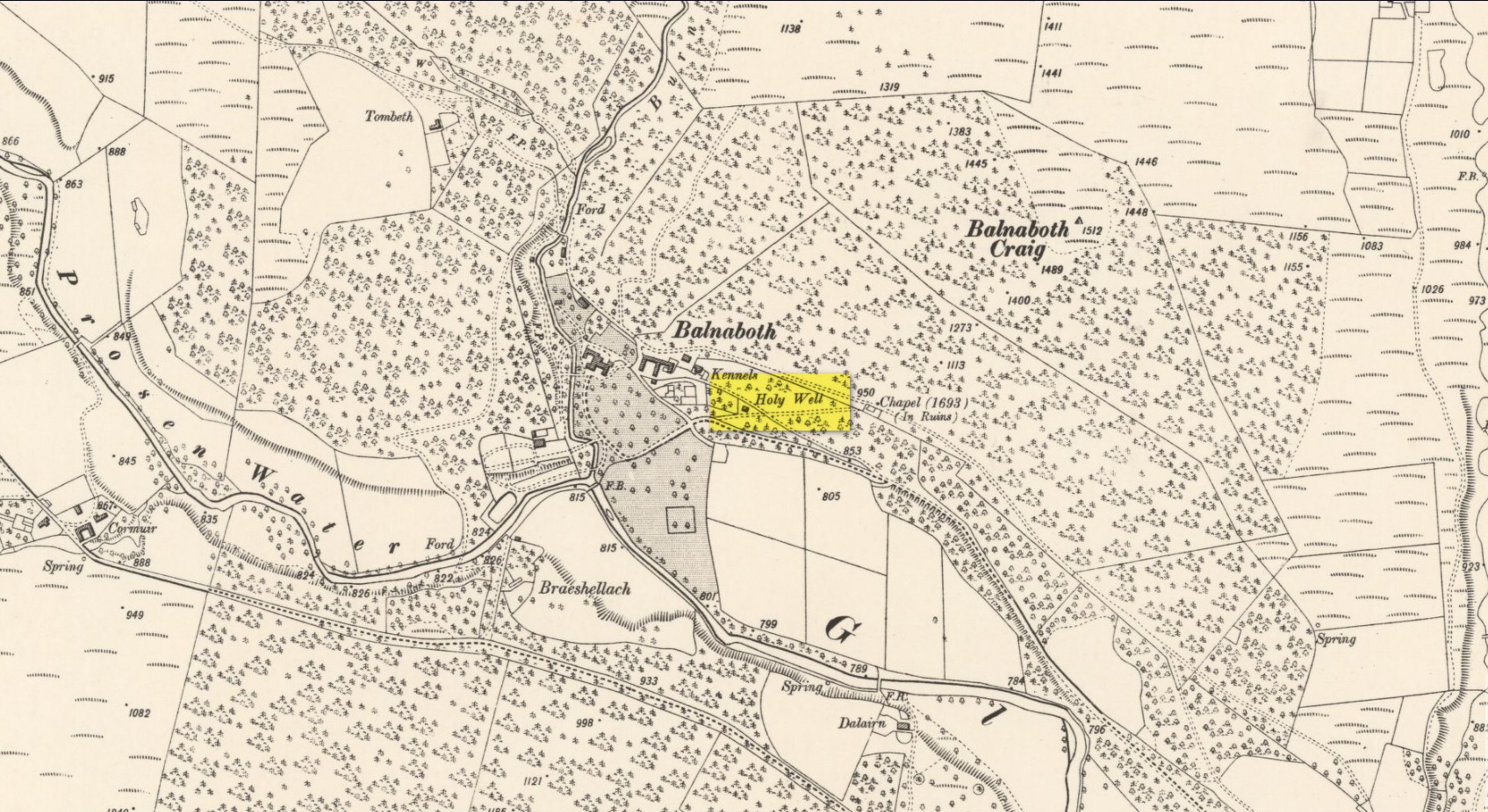
Site shown on 1933 map
First highlighted on the 1933 OS-map of the area, it was located alongside the old fence-line hereby, but no subsequent description of the carving has been made since then. A small boulder and a number of other stones can be found along the line of fencing, but none seem to be possessed of petroglyphs and apart from it being shown on the old maps, I can find no reference or description of it. It may have been destroyed. Some researchers have wondered if the carving was mistakenly marked at this spot by surveyors who confused it with another one more than 500 yards to the southeast (and described by Fred Coles in 1903), but this would seem an unlikely error to have been made. Whilst this was described as a simple “cup-marked stone”, its neighbour at West Lamberkine (2) was a distinct and more complex cup-and-ring design.
References:
Coles, Fred, “Notices of …(4) of Some Hitherto Undescribed Cup-and-ring-marked Stones…” in Proceedings Society Antiquaries Scotland, volume 37, 1903.
Acknowledgements:Many thanks for use of the Ordnance Survey map in this site profile, reproduced with the kind permission of the National Library of Scotland.
A long long way to go for a single little spring! From Kirriemuir town centre go up the B956 Kinnordy Road, going straight across at the crossroads up the countryside lane towards Lednathie (signposted 8 miles): dead straight, long-and-winding, up-and-over…. Stick to this single road, all along, ignoring all turn-off junctions until, once reaching the hamlet of Easter Lednathie, stay awake for the turn up to Glenprosen, 2 miles along, over the bridge. Turn left and a few hundred yards along go over the next little bridge until you reach the “Private Road” sign, then walk up the track past Katy’s Cottage. ¾-mile along just before Balnaboth, keep your eyes peeled to the left for a splatter of quartz rocks with a spring of water thereby. At long long last, you’ve reached your destination!
Archaeology & History
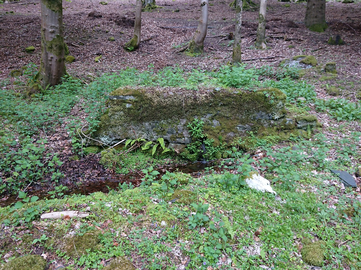
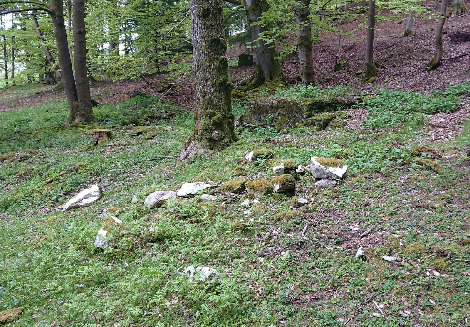
A “splatter of quartz rocks”
Miles to the winding north of Kirriemuir, in the depth of the olde mountains, this clear spring of iron-bearing water (still fresh and drinkable) was, earlier in the 20th century, covered over by someone-or-other and surrounded by straight slabs of stone. The waters were maintained however, by the builders who cut a small hole into the moss-embolded rock allowing this pure water to still run freely for all to use…
Shown on the early OS-maps, its sacrality or holy association would seem to be lost from the tongues of the older folk, most of whom seem long gone from this beautiful glen-to-nowhere. The only remaining religious connection we might have relating to the place comes from the ruined 17th century chapel less than 250 yards away to the west on the slope above the track, from where a singular stone-lined footpath runs dead straight to the well.
Site shown on 1900 OS-map
But another important feature found here is the large scatter of quartz rocks a few yards away from the water source. They are in disarray but would seem to have once been built around the spring where it first emerged from beneath the ground, then being cast aside to their present positions when the more modern stone structure was built above it. We can’t prove this with any certainty, but there are a number of other holy wells with this quartz-defining feature elsewhere in Scotland: the St Mary’s Well at Callander and Beltane Well of Kenmore to name just two.
References:
Robertson, D.O., Long-Ago Legends of Clova, W.P. Nimmo: Edinburgh 1872.
Acknowledgements:Huge thanks for use of the Ordnance Survey map in this site profile, reproduced with the kind permission of the National Library of Scotland.
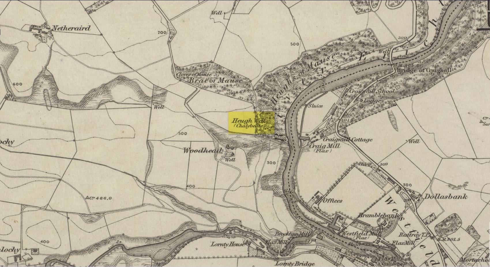
This little-known iron-bearing spring can still be found in the woodland known today as the Heugh of Mawse, a mile north of Blairgowrie. It was included in the Object Name Book of 1863, where they referred to an earlier account in the New Statistical Account, which told that,
“On the south end of it is a chalybeate spring much resorted to by the people of the locality. “There are one or two chalybeate springs in the parish; but they have never been chemically analyzed. There is one very fine spring called the “Heugh Well” It springs from the face of the “Heughs of Mause” (a mortar cliff of singular appearance; which descends abruptly into the bed of the river with an almost perpendicular declivity of about 200 feet) and judging from its colour, contains a considerable quantity of ferruginous matter. The use of its water has been found to be very beneficial in cutaneous eruptions, & affections of the Stomach.””
Heugh Well on 1867 map
Subsequently highlighted on the 1867 OS-map, a singular footpath led to the site and no further. It was mentioned by the regional historians J.G. McPherson (1885) and John MacDonald (1899), albeit briefly, where they respectively told that its waters were “formerly much resorted to by persons in the neighbourhood.” It possessed considerable medicinal properties which, according to tradition, were “found very beneficial for skin diseases and derangement of the stomach”! Doubtless such attributes will still be effective.
Holy Well (destroyed): OS Grid Reference – NO 180 452
Archaeology & History
The Well Meadow in the middle of Blairgowrie was once the place where the 5th century Apostle of the Southern Picts, or St Ninian, baptised local folk into the so-called “new faith”. It’s long since gone. The local historian John MacDonald (1899) told that it was located opposite the buildings on the north-side of the square, adding:
“St Ninian, one of the earliest Christian Celtic missionaries, on his tour through Scotland, pitched his camp where the Wellmeadow now is, and quenched his thirst at an old well or spring which ever afterwards bore the name of “St Ninian’s Well,” until it was covered in and the water led into the town drains.”
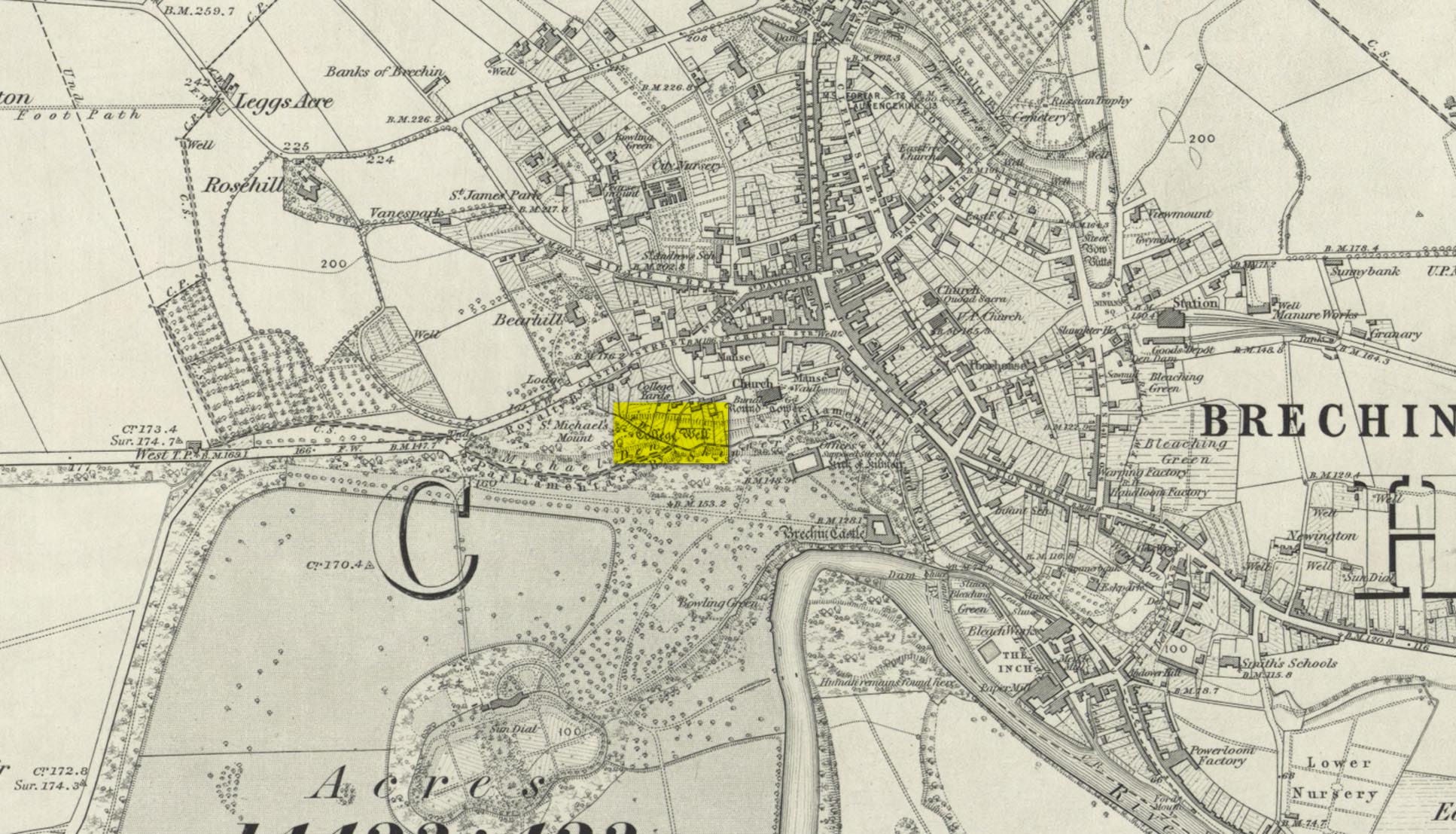
Highlighted on the 1865 OS-map, this lost water source was located between the Brechin cathedral/round tower and the curiously-named St. Michael’s Mount, whose history seems to be lost. It would seem to be the well which Ruth & Frank Morris (1981) name as the ‘Ancient Well’ in their survey.
Folklore
The reason behind this site being classified as a sacred (or holy) well is based on the tradition that the Culdees had a religious convent here in the 12th century and, according to David Black (1839),
“This convent is believed to have stood a little to the west of the present parish church, in the gardens now belonging to the kirk-session, still called “the College Yards.” A small well of delightfully pure water in these gardens receives the name of the College Well, and is reported, by tradition, to have been the well of the Culdee convent.”
On the issue of St. Michael, students of folklore will know that, in the christian cult, he was an early dragon-slayer. His annual commemoration day is September 29. One of his shamanistic functions “relates to the very old tradition of Michael as the receiver of the souls of the dead.” (Attwater 1965)
References:
Black, David D., The History of Brechin, Alexander Black: Brechin 1839.
Gibson, Colin, Folklore of Tayside, Dundee Museum c.1968.
Acknowledgements: Huge thanks for use of the 1st edition OS-map in this site profile, Reproduced with the kind permission of the National Library of Scotland.
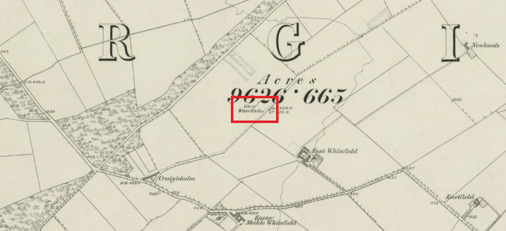
Travelling north from Perth on the A94, take the left hand turn to Strelitz as you go into Burrelton, and follow that road for two miles, and park up about 300 yards past the turning to Gallowhill. The circle stood at the far end (south-east) of the field on your left. Keep the distant gap in the hills in sight and the probable site of the circle is in a dip in the land in front of the ditch.
History & Archaeology
The circle had been destroyed by the middle of the nineteenth century, but was remembered by locals who gave this description to the Ordnance Survey bods:
‘The authorities quoted says that this is the site of a number of standing stones, they formed a circle, and one stood in the centre and according to tradition they were the remains of a Druidical Temple.’
In 1969 an Ordnance Survey archaeologist wrote:
‘There is no trace of this circle, the site being in a level arable field. Immediately to the SE in a ditch running parallel to the fence are about a dozen large boulders cleared from the field, possibly from the site of the circle.’
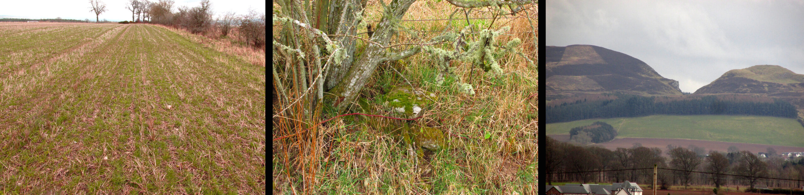
The boulders have now gone but there are some broken stones on the banks of the drainage ditch which may or may not be the sorry remains of some of the stones. There is a depression in the field just in front of the ditch which is the likely site of the circle based on the position shown on the 1867 map.
Left – A faint cropmark which may show the position of the circle in this winter view. Centre – Shattered stones in the ditch bank. Right – View looking south-east from the probable site of the circle – the gap between Black Hill, left and Dunsinane, right
What is interesting is the gap in the horizon facing south east from the site of the circle. On the left of the gap is Black Hill, and on the right Dunsinane Hill of Macbeth fame. My reading of the angle from the probable site of the circle to the gap using a hand held compass was around 135° to 140°, and that may indicate a midwinter sunrise alignment from the lost circle. Something to be checked out when winter comes.
And there is a legend of a giant who leaped from Black Hill to Dunsinane who also tossed a boulder which stands between the two hills – whether this legend has anything to do with the possible solstitial sighting line from East Whitehill is an intriguing question.
Acknowledgements: Big thanks for use of the 1st edition OS-map in this site profile, Reproduced with the kind permission of the National Library of Scotland.
Turn right off the A93 at Cargill onto the side road by Keepers Cottage and up the hill to Gladsfield Wood at the top on your right. Park up at the top side of the Wood and walk straight along the narrow track for around 450 yards and what may be the remains of the stone will be seen between a pair of mature trees.
Archaeology & History
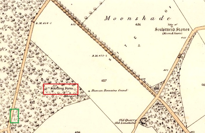
In 1862 the stone was described in the Ordnance Survey Name Book for Perthshire:
‘And about 150 yards from the same object [Hangie’s Well], in a north-westerly direction, there is a small Standing Stone, having the appearance of the ancient monumental standing stones.’
It seems the stone had been removed by the time Fred Coles (1909) came to see it nearly fifty years later. He told us:
“On the day of my visit the mist was so abnormally dense and confusing that it was with considerable difficulty the wood itself was identified; and as its interior is an utter wilderness of trees, shrubs, brambles, broom, wild roses and tall grass, besides being a pheasantry, it is just possible that the monolith searched for evaded my zeal. I think not, however, because, hearing a hedger at work on the Newbigging side of the wood, I made for him; and after plying him with various questions, could get no statement to the effect that he had, though living so near, ever seen any conspicuously tall Stone in the wood.
“On retracing my steps, I searched a fresh portion of the wood, and noticed one biggish block of whinstone lying on the grass in a slight hollow of the ground. It was somewhat cubical, about 2 feet 6 inches square, and fractured. This may he a portion of the former monolith, possibly; and with this dubious result I had to be content.”
In 1967 the archaeologist O.G.S. Crawford described “a sharp-edged boulder standing near the spot marked on the map,” but was not certain if it was the stone. It had no markings on it.
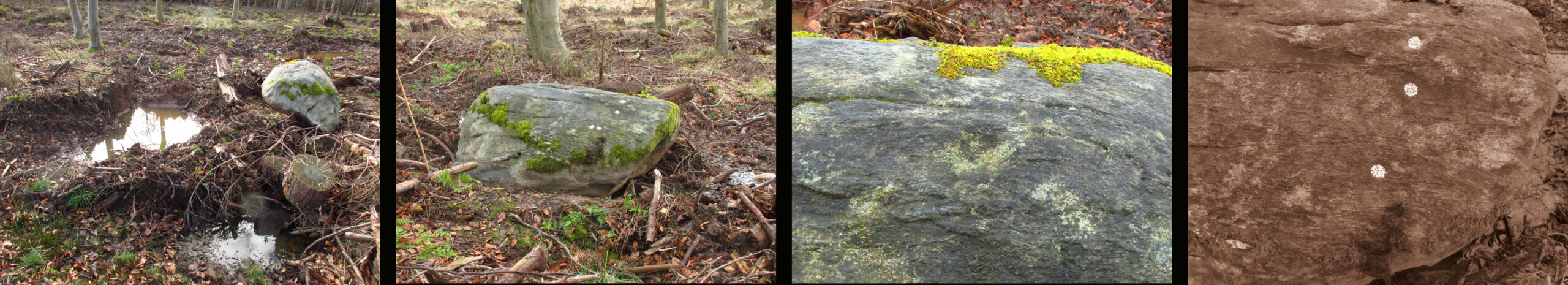
25 in OS map of 1866 showing original position of stone outlined red and position of possible remains of stone in green
Moving on to 2020, and I found the same impenetrable jungle that Coles described more than a century earlier. When a site has been destroyed I can normally take a photograph of where it once was, but not in this case. I continued westward over difficult and potentially ankle snapping terrain that had recently been replanted with conifer saplings, until I got out of the planting area to a line of mature trees next to the track through the wood.
One large elongated stone presented itself that had clearly lain there for many years judging from the moss growth, a short distance away at NO 15641 35478. Could this be the top part of the standing stone, dragged from its original position some 500 feet to the north-east? It is of grey whinstone, heavily veined at the base, with white quartz and tapering to a pointed tip. It has a squarish base measuring approximately 3 feet across by at least 2 feet deep and is some 7 feet in length. It doesn’t look to be natural, so is it a likely candidate for our missing stone? Felled by a man with a hammer and chisel and dragged by a heavy horse to the edge of the field as part of the ‘improvements’, so beloved of nineteenth century landowners…
We can’t prove it is the remains of Hangie’s Stone which may, after all, still lie buried in the boscage…
The possible remains of Hangie’s Stone
The stone in its original position was next to the Roman road from Camelon via Stirling and Muthill to Kirriemuir near to the junction of a road to Inchtuthill Roman Fort, so may have once been a way marker, although it is not of Roman origin.
Turn right off the A93 at Cargill onto the side road at Keepers Cottage and up the hill. Gladsfield Wood is at the top of the hill on your right. Park up at the top side of the Wood and walk along the narrow track to where it crosses another track, look 45º to your right and you’ll see the stone.
Archaeology & History
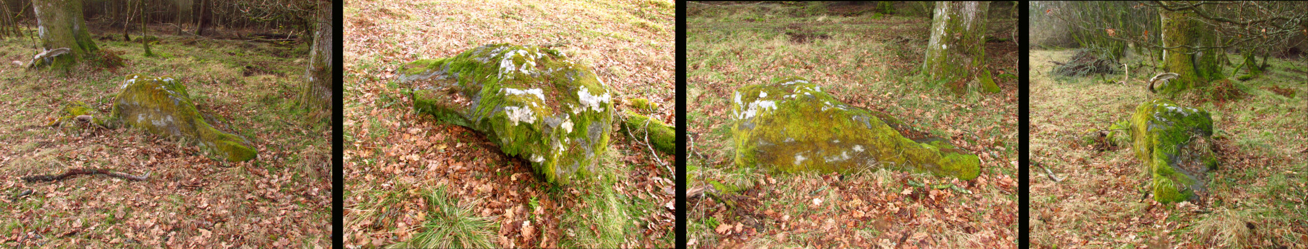
One of those chance finds that turns up when you’re looking for something else. Recent forestry work had dislodged the stone from its original earthfast position of millenia, only a few feet away. It may have been rotated from its original position. The grey whinstone rock measures around 5′ 8″ (1·75 m) long, 3′ 9″ wide (1·15 m ), 2′ 9″ (0·85m) high, and the moss shows its original depth in the ground. Fortunately the cup marks weren’t damaged in what appears to have been a quite brutal move. On what is now the north east facing side there are three definite and one possible very shallow fourth cup mark. The top cup is the most prominent, while the possible fourth cup is just to the left of the bottom one.
L-R 1. The original position of the stone 2. The stone showing the possible fourth cup 3. The prominent top cup 4. The three definite cups
One for the enthusiasts really, in an area of Strathmore quite rich in megaliths and rock art; whatever the future holds for this dislodged stone in the savage world of agri-business, it is now recorded for posterity!
From the centre of Meigle village, you need to head along the country lane south-west towards the village of Ardler (do not go on the B954 road). About three-quarter of a mile (1.25km) along—past the entrance to Belmont Castle—you’ll reach a small triangle of grass on your left, where a driveway takes you into the trees. Walk down the drive and past the very first house—behind which is the stone in question. A small path takes you through the trees allowing you to get round to it. You can’t really miss it!
Archaeology & History
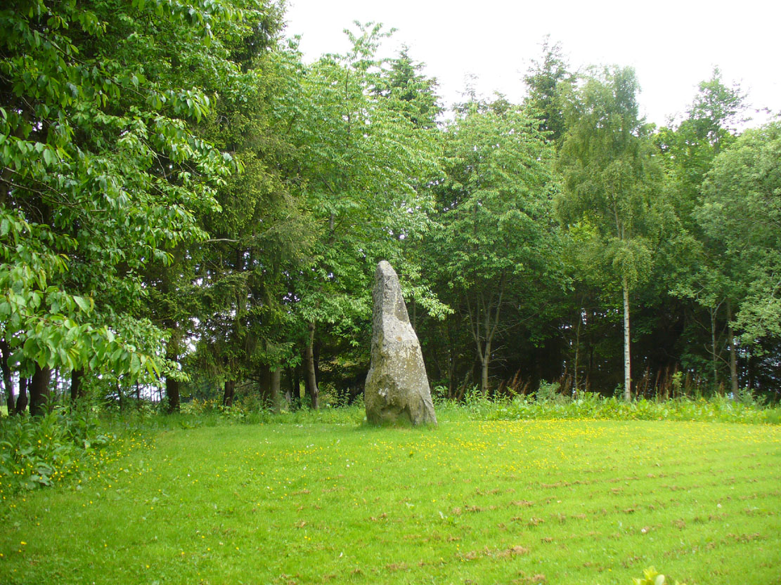
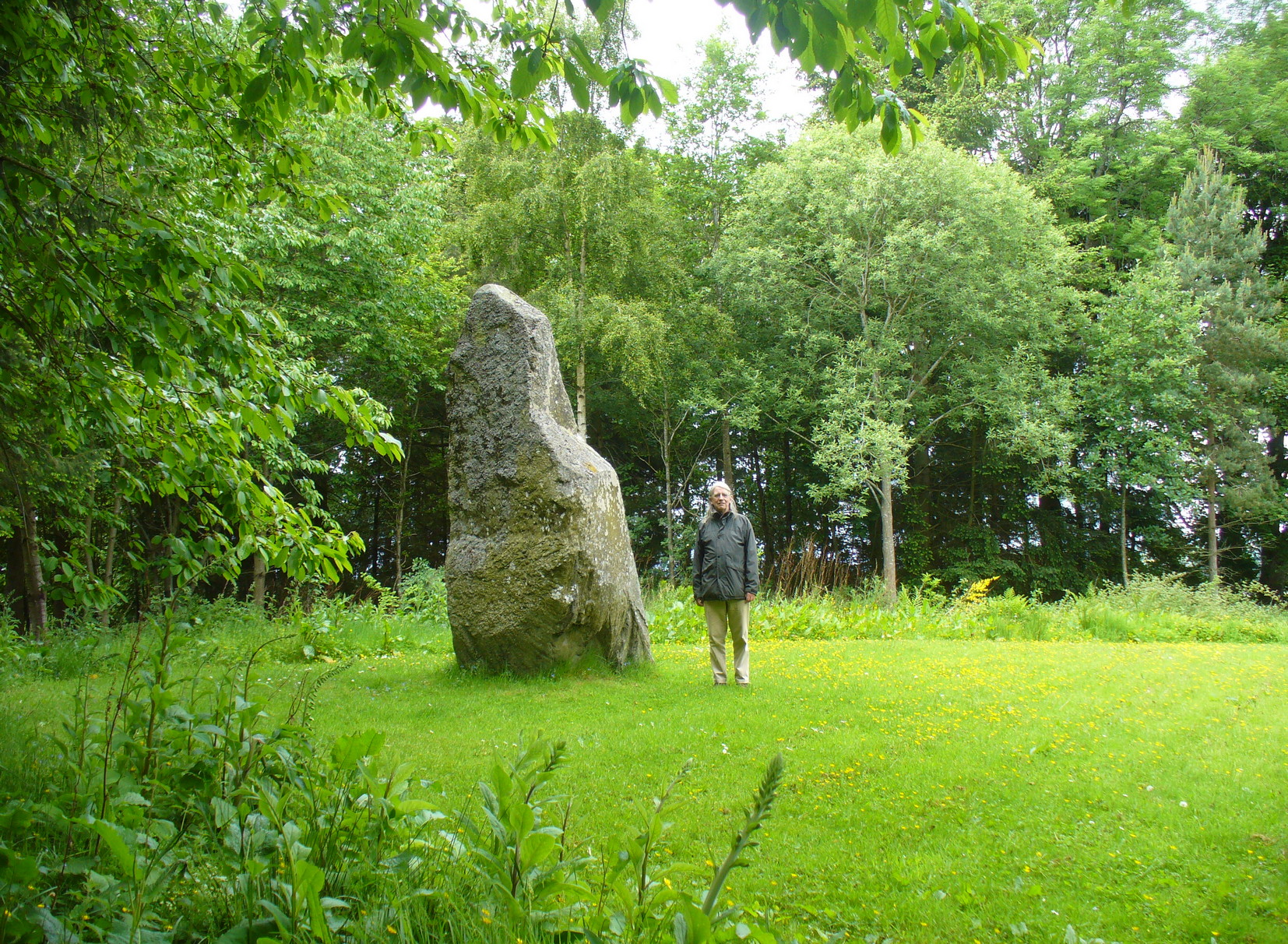
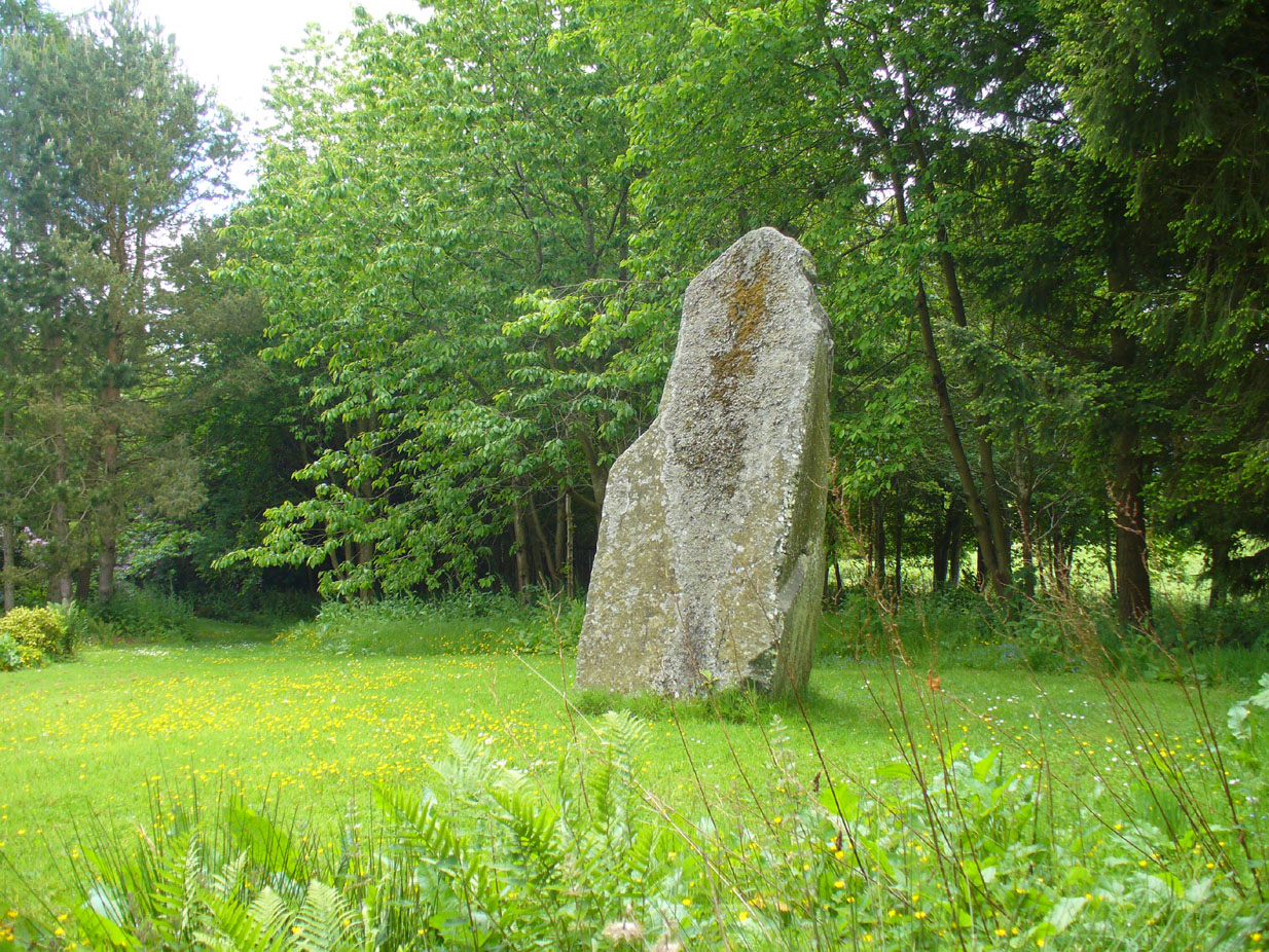
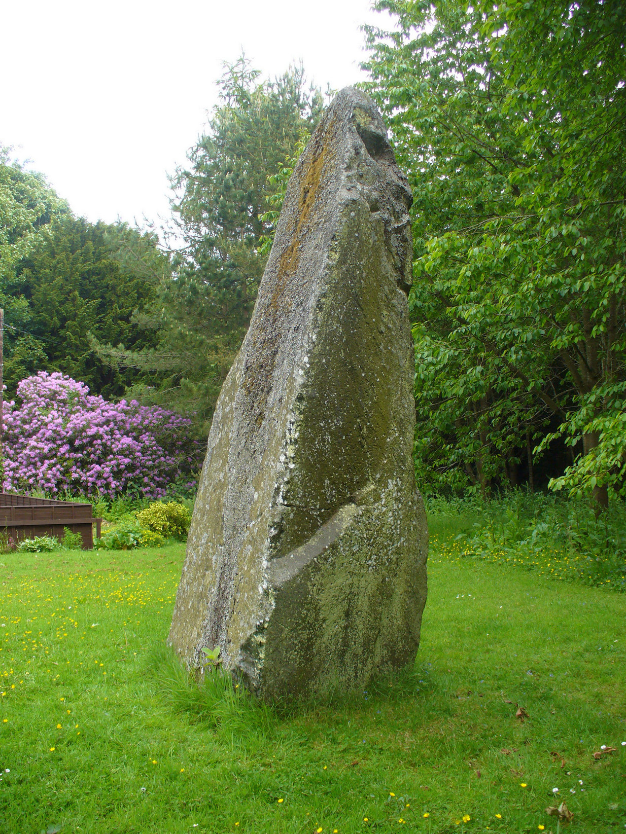
This is a magnificent site. A giant of a stone. Almost the effigy of a King, petrified, awaiting one day to awaken and get the people behind him! It has that feel of awe and curiosity that some of us know very well at these less-visited, quieter megalithic places. Its title has been an interchange between the Scottish King MacBeth and the witches who played so much in his folklore, mixed into more realistic local traditions of other heathen medicine-women of olde…
The first account of this giant standing stone came from the travelling pen of Thomas Pennant (1776) who, in his meanderings to the various historical and legendary sites of Meigle district, wrote that
“In a field on the other side of the house is another monument to a hero of that day, to the memory of the brave young Seward, who fell, slain on the spot by MacBeth. A stupendous stone marks the place; twelve feet high above ground, and eighteen feet and a half in girth in the thickest place. The quantity below the surface of the Earth is only two feet eight inches; the weight. on accurate computation amounts to twenty tons; yet I have been assured that no stone of this species is to be found within twenty miles.”
Site shown on 1867 mapA human & MacBeth!
It was visited by the Ordnance Survey lads in 1863, several years after one Thomas Wise (1855) had described the monolith in an article on the nearby hillfort of Dunsinane. But little of any substance was said of the stone, and this is something that hasn’t changed for 150 years, despite the huge size of this erection! Local historians make mention of it in their various travelogues, but the archaeologists haven’t really given the site the attention it deserves. Even the Royal Commission (1994) report was scant; and apart from suggesting it to have a neolithic provenance, they merely wrote:
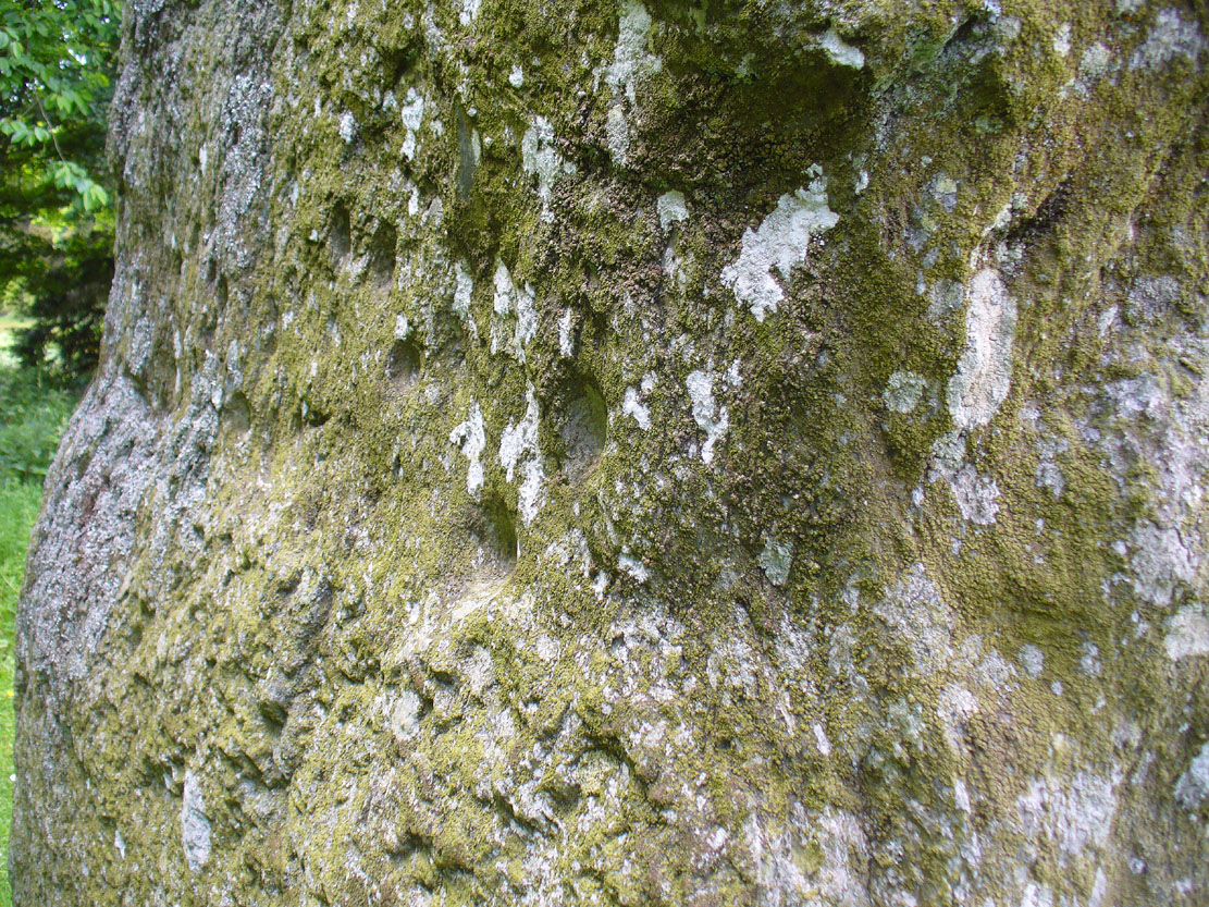
“Rectangular in cross-section, the stone tapers to a point some 3.6m above the ground; each of its sides is decorated with cupmarks, as many as forty occurring on the east face and twenty-four on the west.”
East face of MacBethMacBeth Stone (Wise 1884)
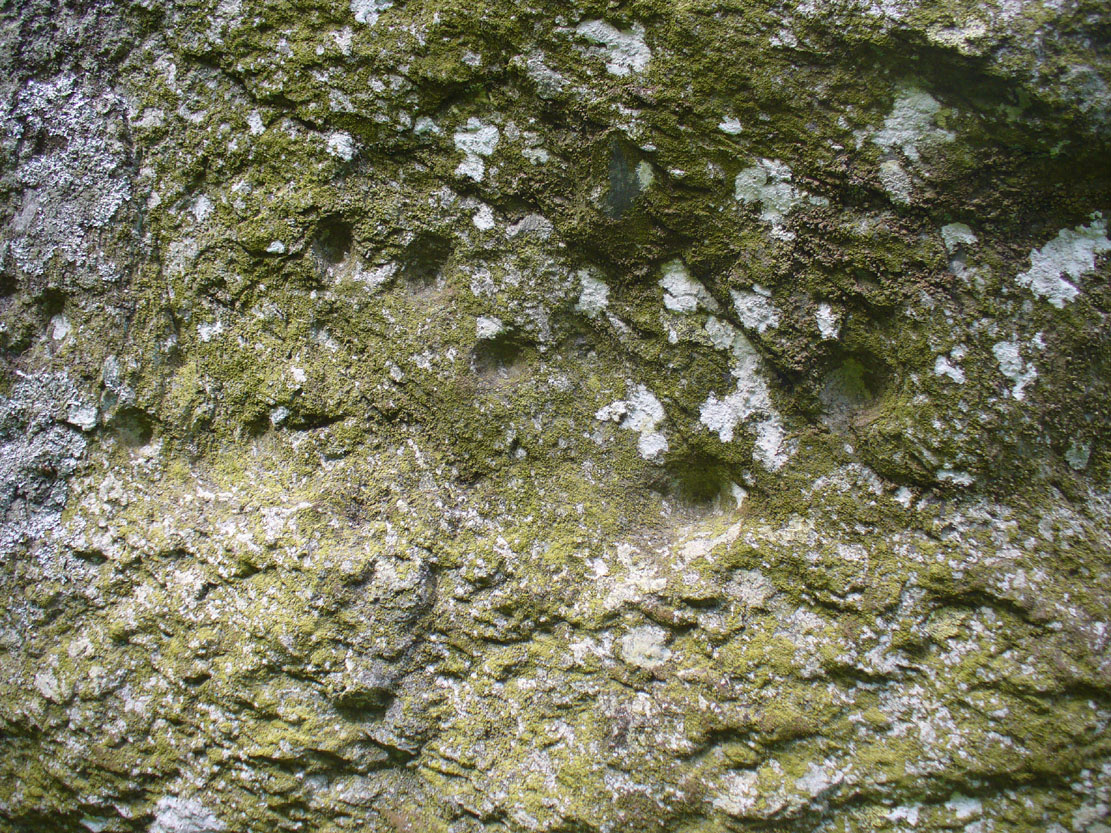
Thankfully, the fact that there are cup-markings on the stone has at least given it the attention it deserves amongst the petroglyph students. The first account of the cup-markings seem to have come from the pen of Sir James Simpson (1867) who mentions them, albeit in passing, in his seminal work on the subject. A few years later however, the same Thomas Wise visited MacBeth’s Stone again, and not only described the carvings, but gave us our first known illustration in his fascinating History of Paganism (1884). He told it to be,
“A large boulder, some 12 tons in weight, situated within the policies of Belmont Castle, in Strathmore, Perthshire…is supposed to have been erected on the spot where MacBeth was slain. Two feet above the ground this boulder has a belt of cups of different sizes, and in irregular groups. None of these cups are surrounded by incised circles or gutters. This boulder was probably intended for some sacred purpose, as it faces the SE.”
Running almost around the middle of the standing stone, on all four sides, are the great majority of the cup-markings (no rings or additional lines are visible). They were very obviously etched into the stone after it had been erected, not before. This is in stark contrast to the cup-and-rings found on the standing stones at Machrie, Kilmartin and elsewhere, where we know the carvings were done before the stones were stood upright.
Cup-marks on west sideCup-marks on west face
On the northern face of the stone is one possible cup-marking, and three of them are etched onto its south face; but the majority of them, forty, are on its western face, and twenty-five on its eastern side. The great majority of them on the east and west sides occur roughly in the middle of the stone, almost like a ‘belt’ running across its body. Those on the eastern face are difficult to discern as a thick layer of lichens covers this side, so there may be even more beneath the vegetation.
One of the notable features of the monoliths across this region, and echoed again here, is that one side of the standing stone is smooth and flat—and here in the case of MacBeth’s Stone, the flat face is the eastern one. Whether this feature was deliberately intended (it seems to have been) and what it might imply, we can only guess. It might simply relate to the geophysics of the stone, making it easy to crack horizontally….
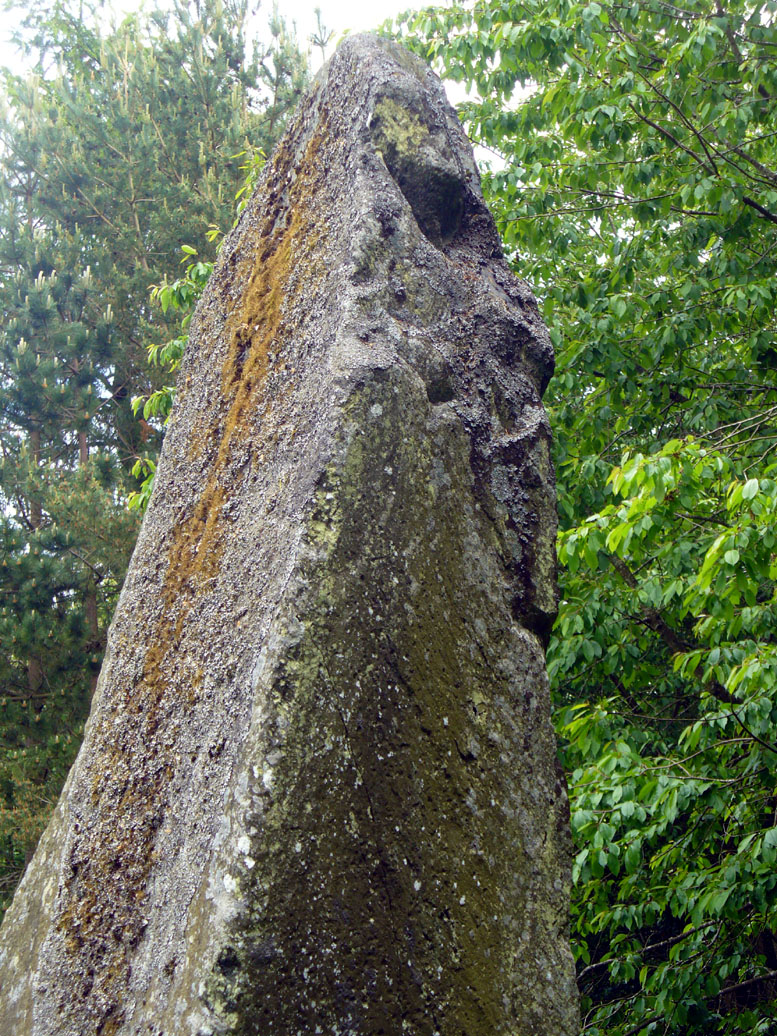
The ‘face’ in the top of the stoneClose-up of Macbeth’s face
Another fascinating feature at this site was noticed by Nina Harris of Organic Scotland. Meandering around the stone in and out of the trees, she called our attention to a fascinating simulacra when looking at the upper section of the stone on its southern side. At first it didn’t seem clear – but then, as usual, the more you looked, the more obvious it became. A very distinct face, seemingly male, occurs naturally at the top of the stone and it continues as you walk around to its heavily cup-marked western side. It’s quite unmistakable! As such, it has to be posited: was this simulacra noticed by the people who erected this stone and seen as the spirit of the rock? Did it even constitute the reason behind its association with some ancestral figure, whose spirit endured here and was petrified? Such a query is neither unusual nor outlandish, as every culture on Earth relates to such spirit in stones where faces like this stand out.
But whatever your opinion on such matters, when you visit this site spend some time here, quietly. Get into the feel of the place. And above all, see what impression you get from the stony face above the body of the stone. Tis fascinating…..
Folklore
Known locally as being a gathering place of witches, the site is still frequented by old people at certain times of the year, at night. The stone’s association with MacBeth comes, not from the King himself (whose death occurred many miles to the north), but one of his generals. In James Guthrie’s (1875) huge work on the folklore of this region, he told that this giant
“erect block of whinstone, of nearly twenty tons in weight…(is) said to be monumental of one of his chief officers”,
which he thought perhaps gave the tale an “air of probability about it.” But Guthrie didn’t know that this great upright was perhaps four thousand years older than the MacBeth tradition espoused! However, as Nick Aitchison (1999) pointed out in his singular study of the historical MacBeth,
“another MacBeth was sheriff of Scone in the late twelfth century and it is possible that he, and not MacBeth, King of Scots, is commemorated in the name.”
He may be right. Or it the name may simply have been grafted onto the stone replacing a more archaic relationship with some long forgotten heathen elder. We might never know for sure.
When Geoff Holder (2006) wrote about the various MacBeth sites in this area, he remarked that the folklore of the local people was all down to the pen of one Sir John Sinclair, editor of the first Statistical Account of the area—but this is a gross and probably inaccurate generalization. Nowhere in Holder’s work (or in any of his other tomes) does he outline the foundations of local people’s innate subjective animistic relationship to their landscape and its legends; preferring instead, as many uninformed social historians do, to depersonalise the human/landscape relationships, which were part and parcel of everyday life until the coming of the Industrial Revolution. Fundamentally differing cultural, cosmological and psychological attributes spawned many of the old myths of our land, its megaliths and other prehistoric sites. It aint rocket science! Sadly, increasing numbers of folklore students are taking this “easy option” of denouncement, due to educational inabilities. It’s about time researchers started taking such misdirected students to task!
References:
Aitchison, Nick, MacBeth – Man and Myth, Sutton: Stroud 1999.
Coutts, Herbert, Ancient Monuments of Tayside, Dundee Museum 1970.
Royal Commission on the Ancient & Historical Monuments of Scotland, South-East Perth: An Archaeological Landscape, HMSO: Edinburgh 1994.
Simpson, James, Archaic Sculpturings of Cups, Circles, etc., Upon Stones and Rocks in Scotland, England and other Countries, Edmonston & Douglas: Edinburgh 1867.
Acknowledgements: With huge thanks to Paul Hornby for his help getting me to this impressive monolith; and to Nina Harris, for prompting some intriguing ideas.
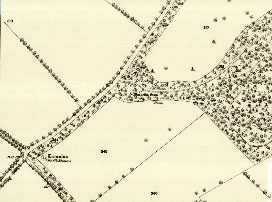
Going north-eastish from the city of Perth, take either the A93 or A94, turning west along the A93 a mile south of Guildtown, or east at Balbeggie on the A94, until you reach St. Martin’s hamlet and park up just below the church opposite the old cottages. Walk up the track below the cottages (not the one above them!) for ⅘-mile (1.35km) [past the ruined Cupar Stone Circle], and where the land has levelled out and in the huge flat field on your left, you’ll eventually reach a gate and see the odd-looking ‘rock’ about 250 yards away in the middle.
Archaeology & History
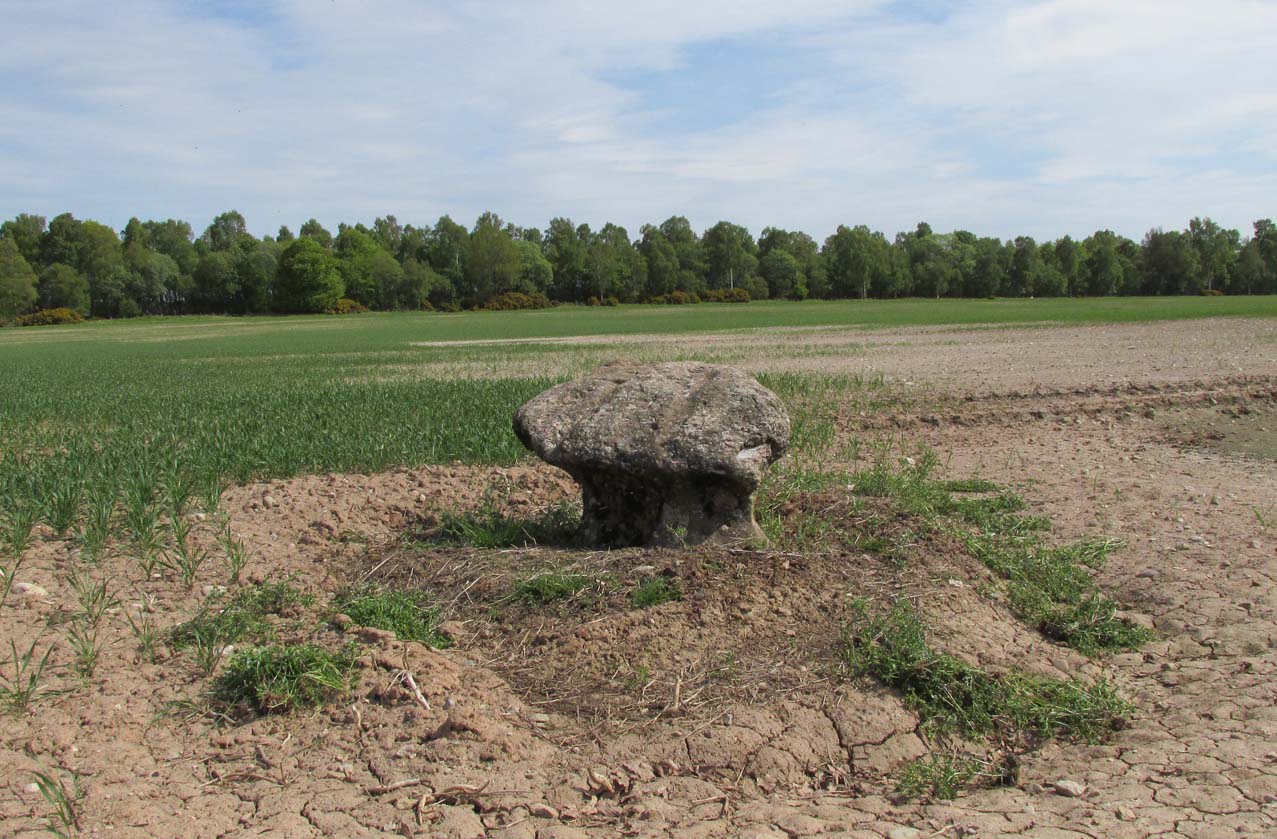
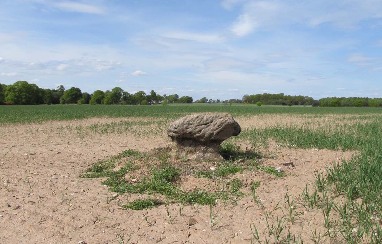
A fungal morel turned to stone
In a quiet and little-known parish that was once littered with about a dozen stone circles, there remains a most curious and fascinating stone which, in earlier days, was to be seen on the open moorlands at this spot. The area was then forested and then the agriculturalists came with their farming and destroyed the forests, leaving the old stone as it presently stands, isolated, above the hamlet of St. Martin’s to the south. Although it was described in the 19th century as being “four feet high”, it stands barely three feet tall, is very curiously-shaped—just like a morel mushroom from some angles—and in the middle of an extensive piece of flatland where the crops barely grow.
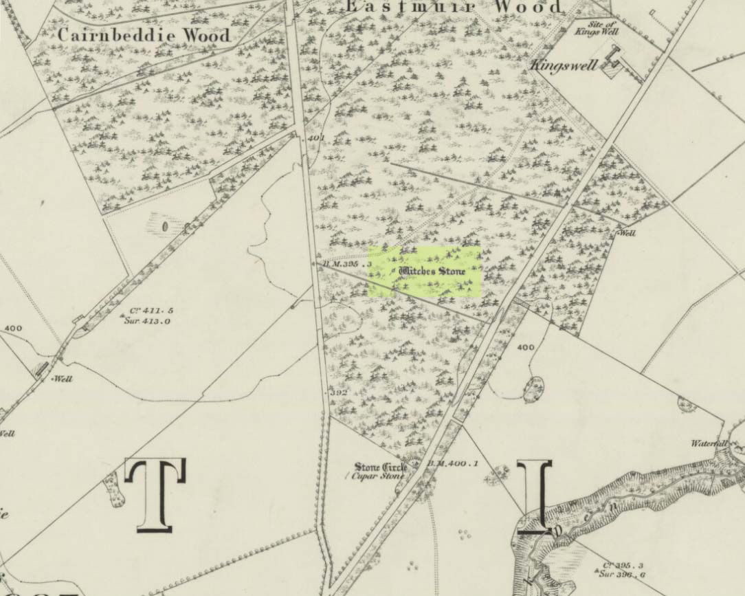
Witches Stone on 1866 map
Witches Stone, looking west
The stone was highlighted on the first OS-map of the parish in 1866, showing it in the woodland plantation of Eastmuir. It may have been some sort of northern outlier related to the now-destroyed stone circle of Cupar 400 yards south; and if this was the case, its position in the landscape relative to the circle would give the Witches Stone an airt (virtue ascribed to cardinal directions) in the cycle of the year that relates to darkness and death. (Perhaps oddly—perhaps not—the name of parish St. Martin’s relates to that dark period in the calendar, as St. Martin’s day in the old calendar was Samhain or Halloween: old New Year’s Day, when the spirits of the dead moved across both land and skies.)
It was erroneously described by the Canmore lads as being little more than “a glacial erratic”, but the stone here is quite earthfast; and their idea that “its peculiar shape has probably been caused by wind erosion”, is also somewhat dubious considering the shape of other monoliths and megalithic rings in the region. The stone has an appearance similar to some Bull Stones, where the animal was chained to rocks such as this and then baited by dogs, although I can find no such lore here. Indeed, the history and archaeology of the stone seems all but silent. Its folklore however, would have the Shakespearian romanciers amongst you flocking to the place…
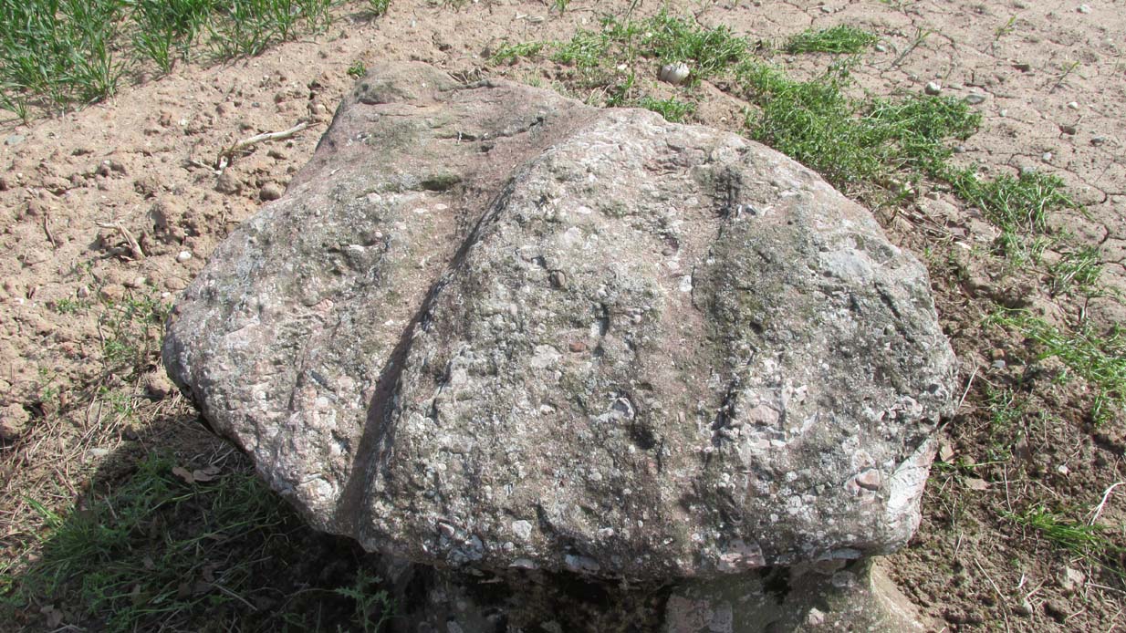
Deep grooves atop of the stone
The top of the stone has some very distinct and deep-cut lines running across it at angles, and has the appearance of being cut into at some time in the dim and distant past. By whom, and for what reason, we cannot say.
Folklore
William Richie (1845) told us that in the 11th Century when Scotland was having to deal with the english disease of stealing land and spreading its violence, King MacBeth—whose castle stood within this parish at Cairnbeddie (NO 1498 3082)—took that advice of two witches, and that
“they met him one night at a place still called ‘the Witch Stane’ (where a remarkable stone still stands), about a mile from his old residence, and warned him to beware, ‘Till Birnam forest come to Dunsinane.’”
The 1860 Name Book told us that,
“The Moor where the witches met, which is in St. Martins Parish is yet pointed out by the country people, and there is a stone still preserved, which is called the Witches Stone.”
References:
Scott, Aleander, St. Martin’s and Cambusmichael, Perth 1911.
Richie, William, “St. Martins and Cambusmichael,” in New Statistical Account of Scotland – volume 10: Perthshire, William Blackwood: Edinburgh 1845.
Acknowledgements: Huge thanks to Prof Paul Hornby for showing me this site. Cheers matey!