Holy Well: OS Grid Reference – NO 3172 6681

A long long way for a single little spring, go from Kirriemuir town centre up the B956 Kinnordy Road, going straight across at the crossroads up the countryside lane towards Lednathie (signposted 8 miles): dead straight, long-and-winding, up-and-over…. Stick to this single road, all along, ignoring all turn-off junctions until, once reaching the hamlet of Easter Lednathie, stay awake for the turn up to Glenprosen, 2 miles along, over the bridge. Turn left until and a few hundred yards along go over the next little bridge until you reach the “Private Road” sign, then walk up the track past Katy’s Cottage. ¾-mile along just before Balnaboth, keep your eyes peeled for a splatter of quartz rocks with a spring of water thereby. At long long last, you’ve reached your destination!
Archaeology & History

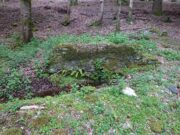
Miles to the winding north of Kirriemuir, in the depth of the olde mountains, this clear spring of iron-bearing water (still fresh and drinkable) was, earlier in the 20th century, covered over by someone-or-other and surrounded by straight slabs of stone. The waters were maintained however, by the builders who cut a small hole into the moss-embolded rock allowing this pure water to still run freely for all to use…
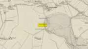
Shown on the early OS-maps, its sacrality or holy association would seem to be lost from the tongues of the older folk, most of whom seem long gone from this beautiful glen-to-nowhere. The only remaining religious connection we might have relating to the place comes from the ruined 17th century chapel less than 250 yards away to the west on the slope above the track, from where a singular stone-lined footpath runs dead straight to the well.

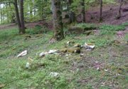
But another important feature found here is the large scatter of quartz rocks a few yards away from the water source. They are in disarray but would seem to have once been built around the spring where it first emerged from beneath the ground, then being cast aside to their present positions when the more modern stone structure was built above it. We can’t prove this with any certainty, but there are a number of other holy wells with this quartz-defining feature elsewhere in Scotland: the St Mary’s Well at Callander and Beltane Well of Kenmore to name just two.
References:
- Robertson, D.O., Long-Ago Legends of Clova, Edinburgh 1872.
Acknowledgements: Huge thanks for use of the Ordnance Survey map in this site profile, reproduced with the kind permission of the National Library of Scotland.
© Paul Bennett, The Northern Antiquarian
