St. Margaret’s Well, Binsey, Oxford, Oxfordshire

Holy Well:  OS Grid Reference – SP 486 080

Archaeology & History

A sacred water source that is thought to have taken its name from the adjacent church of St. Margaret (makes sense!).  The site was described at some length in the fine work of Robert Charles Hope (1893), where he quoted extensively from earlier works:

“At the west end of this chappel, about three yards distant, is the well or spring, antiently and to this day called St. Margaret’s Well, being the very same that she by her prayers at the building of the chapple opened. Of which heare a certaine old English poet, who in the life of St. Frideswyde in the legend of English saints, speaking of her various fortunes and of her passage from Bampton to this place, saith thus:

Ther fer with her [fellows.] she be laft ther
And to serve Jhesu Christ . a chapel leet [raise.]
Ther as is yit a fayr cort . and a cherche fayr and swete
Arerid in the honour . of her and Seynte Margrete
As this mayde [lived.] ther . in holy lyf and clene
The maydenes that were with her . gone hem ofte be [bemoan.]
That water was sum del to fer . hem ofte for smale dede
And cride on Seynt Friswid . that she schold hem therof [rid]
This mayde Seynt Friswid . bad our lordis sonde
That he water thorw his gras . hem sente ner honde
So sprong ther up a welle . cler [enough] and clene
That fond hem water inowf . tho dorst hem nought be mene
That beside the cherche is [it] . in the west syde
That mony a mon hath bote do . and that men seggeth wide.

Over St. Margaret’s Well was a covering of stone, and thereon on the front the picture of St. Margaret (or perhaps St. Frideswyde), pulled down by Alderman Sayre, of Oxon, a little before the late war, 1639.

To this well also and her image and certaine reliques in the chapple did the people come on pilgrimage with as great devotion to ease their burdened soules and obtaine resolutions of their doubts, as they would to an oracle.

And here, also, when those maimed and unsound folke had bin cured either by bathing in, or drinking of; this water, hang up their crutches as a speciall memorandum of their cured griefs. For which end and purpose there were severall preists that inhabited here appointed by the Prior of St. Frideswide’s purposely to confess and absolve those pilgrims.

Near to this place it was that the Lady Edyne, of Wynton, the widdow of Sir William Lancelot, knight, had a vision. (See Twyne, xxi., 199.)

The well wee find almost to the last frequented by superstitious people, and especially about a hundred years before the dissolution.  Soe much, that they were forced to enclose it–as in old time before, they had defended it–with a little house of stone over it with a lock and a dore to it. But all decaying and going much to ruine, at the suppression of St. Frideswyde’s Priory, was at last –I meane the little house–about twenty-five years agoe, pulled downe and quite taken away. Soe that now being overgrowne with nettles and other weeds, and harbouring frogs, snails, and vermin, scarce owneth the name of a well; noe more than the old and small building joyning to the north side of the chapple doth–as formally it did–a court.

The well is now in better condition. When I visited it on 25th October, 1887, the churchyard was tidily fenced and very neatly kept. At the well a descent of some five steps brought one to an arched vault, beneath which, in the centre of the flooring, was a round basin containing the water of the well, the surface of the water being about six feet below the level of the ground.  On the wall above the arch was this inscription:

“S. MARGARET’S WELL.

S. Margaretae fontem, precibus S. Frideswidæ (ut fertur) concessum, nquinatum diu obrutumque in usum revocavit T. J. Prout, Aed. Xti alumnus, Vicarius, A. S. MDCCCLXXIV.

At the time of the restoration of this well, an Oxford wit, having regard to its proximity to the church, suggested for an inscription:

Ariston men hydor
When you open your pew-door,
This may comfort supply
Should the sermon be dry.

(Ibid., pp. 323-328, et seq.)

Denham Tracts, p. 151: The well of St. Margaret or St. Frideswide, in Binsey churchyard, scarce two miles from Oxford, is supposed to have sprung from the prayers of St. Frideswide, and many in olden times consulted it as an oracle on the state of their burdened souls; maimed and sick persons drank and bathed in the waters, and were cured by them. The stone edifice was in the last century destroyed, but has been restored.“

References:

  1. Hope, R.C., The Legendary Lore of the Holy Wells of England, Elliot Stock: London 1893.

© Paul Bennett, The Northern Antiquarian 


Clach na Sithean, Strathtay, Perthshire

Cup-Marked Stone:  OS Grid Reference – NN 895 531

Also Known as:

  1. Balendune
  2. Ballinduin

Folklore

This large cup-marked stone was known by local people as the Clach na Sithean, or the stone of the fairies.  Its smooth surface and well-cut grooves was said to be due to the fairies sharpening their knives upon it, and the straight cuts or grooves were tests of the keenness of their blades.

In addition to the fairies having hold over this stone, a brownie creature also roamed between here and the burn of Allt Mor.  Although a dutiful creature, he commonly used to scare the women when they returned from the ceilidhs by chasing them and screaming a curious noise at them. But as well as this, he would also enter the local houses and farms after nightfall and, when the local folk were asleep, would clean the supper dishes and put them in their rightful places. But if there was no work to be done once he had entered their homes, he would take the dishes out and place them on the floors where they would be found in the morning by perplexed householders.  Then they’d know that the brownie had visited. Sometimes he was a great help to the housewives, other times a nuisance.  He became known to local people as Puddlefoot, or Cas an Lubain, but so offended was he by the name when he heard it, that he let out an almighty scream and vanished, never to be seen again.

References:

  1. Kennedy, James, Folklore and Reminiscences of Strathtay and Grandtully, Munro Press: Perth 1927.

© Paul Bennett, The Northern Antiquarian


St. Agnes’ Well, Cothelstone, Somerset

Holy Well:  OS Grid Reference – ST 183 318

Folklore

In this lovely little hamlet we find an ancient well, registered as a scheduled monument in its well-house, but with a long history and lots of legends. It was said to have been a wishing well of considerable power, but many local people wouldn’t use it because it was also the place where mischievous pixies lived. It seems that one of its main magical properties was to divine the love of a person. The writer Ruth Tongue (1965) told a long tale she came across in her county folklore book about such a fortune:

“There was a maid servant, see, and she were coming on in years and she do serve a farmer’s wife as were high in station. Proper tackalackey she made of the dear soul, and she having no living kin. Twas pitiful, and her a-longing for a parcel of children underfoot, even if ’twas only to call her Auntie. But there, ‘twadn’t to be, and her with a heart so full a-drip with loving kindness as a honey comb. Oh, she were a proper mannerly maiden, no ways like her mistress who were just a old ewe dressed up lambs fashion and spending her days living two-three steps from nothing. But it didn’t seem like the maiden couldn’t never meet up with a proper man for her. She wadn’t no summer morning to look at, poor soul, and her mistress kept her so thin as a yard of pump water. But there Providence knows best! There were a old fellow over by Aisholt, and he were such a upstanding courageous man he’d a never got round to marrying, let alone finding the bravery to walk arm in crook with a maiden. Well o’ course he were lonely like she. And it come to a St. Agnes Eve when maids creepy over to her well at Cothelstone and whisper their heart’s desire when ’tis dark, and if St. Agnes do fancy the maiden she’ll send a husband that year. Now the poor maid she were coming to the end of her days of womanhood and beginning to blossom about the head, and she were desperate unhappy about it. Her heart was all a-set on children, and she find bravery to slip out after farm’s a-locked up. She didn’t feel ’twere mannerly to worrit St. Agnes over one who was so on in years when there was young maidens as plentiful as blackberries, so what do the dear soul do but go down all in the dimmit to the Wishing Well in Seven Wells Coombe. Proper unket well ’tis, and hard tew find. But St. Agnes must ha’ knowed, for she found’n though there wadn’ but little moon and old fellow he d’hear summat down in coombe and come to look-see. He were a wise old man and nothing hurted he, but he were shy of folks, seems like. Well, whether ’twere St. Agnes I can’t say, but in a year the farm was sold up and the maid was a-wed to the old fellow. So quiet as a sheep the man was, wouldn’ downarg no-one, but he made her a good husband. In a year or two she’d a babe in the cradle and one under her apron, and two clinging to her skirts, and they was all so happy as daisies in the sunshine, as they say.”

References:

  1. Tongue, Ruth, Somerset Folklore,FLS: London 1965.

© Paul Bennett, The Northern Antiquarian

Tobar Mor, Tarbert, Gigha, Argyll

Sacred Well:  OS Grid Reference – NR 6564 5190

Also Known as:

  1. Canmore ID 38609
  2. Great Well of the Winds
  3. St Beathag’s Well
  4. Tobar Bheathaig

Folklore

There are a number of sacred and healing wells on this small island, but this site in particular was deemed magickal by folk from far and wide.  Found on the northwest slopes of Cnoc Largie (around which are other heathen spots) this legendary site had an attendant keeper of the well:

“an aged female direach, or guardian, whose uncanny powers could be commanded by a small offering of silver.  Following this the cover of the sacred well would be removed in order that its waters might be ceremonially cleansed with a white clamshell prior to being stirred three times, sunwise, to the accompaniment of ritual incantations.  Then three shell-fulls of the sacred water would be hurled aloft in the direction of the desired wind which, before the day was out, invariably appeared.”

This simple ritual obviously tells that it was a heathen site, seemingly one for divination and magick.  Another piece of folklore (found at other wells) told that if the cover on the well were left unattended, its waters could overflow and flood the entire island.

References:

  1. Anonymous, Exploring Historic Kintyre and the Isle of Gigha, Harlequin Press: Oban n.d.

© Paul Bennett, The Northern Antiquarian
The Bodach and Cailleach, Gigha, Argyll

Sacred Stones:  OS Grid Reference – NR 6382 4730

Folklore

The Bodach and the Cailleach
The Bodach & the Cailleach

On this “Isle of the Gods” — as some historians proclaim Gigha to mean — the ancient rites and ceremonies of local folk continued until pretty recent times.  One writer narrated some intriguing pre-christian events connected to this curious and little-known place, speaking of indigenous heathen rites:

“These are in fact known to have persisted on the island until well into the early part of the (19th) century when Irish fishermen could still be seen climbing the little hill of Moinean Sitheil, in the sacred Moss of Peace below Ardminish, to pay homage to the “Old Ones” of Gigha: a pair of ancient legend-shrouded stones known as the Bodach and the Cailleach, that from time immemorial have stood upon a low green knoll below the farm of Achamore.

“Through the countless ages the strange jug-headed little Bodach and his smaller consort have kept steadfast vigil over Gigha: their mysterious aura said to guarantee its continuing fertility and prosperity as they link the thriving island of today with beliefs and traditions having roots in the earth-cults and sun-worship of primeval times.  In the past folk would have honoured them with offerings of meal or milk and even now they still command considerable local affectation and respect, albeit expressed in less overtly pagan ways.  And so they stand as ever upon their tiny hillock gazing out across tumbling terraces of old Cantereoch and beautiful Ardlamey Bay, inscrutable and silent, yet with a strangely ‘knowing’ air impossible to define.”

References:

  1. Anonymous, Exploring Historic Kintyre and the Isle of Gigha, Harlequin Press: Oban n.d.

© Paul Bennett, The Northern Antiquarian


Thursday Market Cross, York, North Yorkshire

Cross (destroyed):  OS Grid Reference – SE 603 519

Archaeology & History

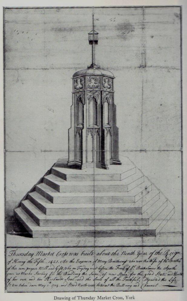
Early drawing of York’s Market Cross

This old cross was demolished long since, but I think it’s important to rejunevate a memory of its existence back into our times.  Little has been written about the site as it was destroyed more than 200 years ago and images of the edifice are rare indeed!  It was found near the modern centre of the city and although this ornate-looking thirty-foot tall cross was obviously impressive, an even earlier upright stone stood here in the 13th and 14th century.  But this new carved monument took precedence over its older and lesser upright.  First described — I think! — by Thomas Gent (1730), he told us that,

“The old cross stood towards the Kennel, against the middle of the market.  The lower part was an octagon, had an ascent of six high steps, covered with Tyles for Butchers, higher up with nitches, in which had been effigies and a small pillar above with four Dials and over them a Fane.”

A few years later when Francis Drake (1788) described the same monument, he added very few extra details; though told us it had five steps and not six — but this seems to have been an error on his behalf.  In C.B. Knight’s (1944) work we have what seems to be the most complete historical description of this lost stone edifice.  He wrote:

“In 1429 a new stone cross had been erected in Thursday Market in place of its predecessor by Marion Braythwayt, widow of John Braythwayt, who was Lord Mayor in 1394… This Cross was described by a writer in 1683 as “a fair Cross of stone, built upon the ascent of five steps, and hath neatly cut in stone a turret or battlement eight square, upon which is placed a round pillar with a four-square stone upon the top, which hath a sundial placed upon every square, and a vane above.  The Cross hath a penthouse round about it, covered over with tile, to shelter the market people in rainy weather, and is supported upon eight posts, upon one of which, on the south side, is fixed an iron yard-wand, the standard measure of the market.”  In 1705 the ancient Market Cross…was pulled down.”

References:

  1. Cobb, Gerald, “Note on a Drawing of Thursday Market Cross, York,” in The Antiquaries Journal, 43:1, 1963.
  2. Davies, Robert, Walks about the City of York, Nichols & Sons: Westminster 1880.
  3. Drake, Francis, Eboracum; or the History and Antiquities of the City of York, Wilson & Spence: York 1788.
  4. Gent, Thomas, The Antient and Modern History of the Famous City of York, Thomas Hammond: York 1730.
  5. Knight, Charles Bruton, A History of the City of York, Herald: York & London 1944.

© Paul Bennett, The Northern Antiquarian 

Ardfernal, Jura, Argyll

Standing Stone:  OS Grid Reference – NR 56009 71718

Also Known as:

  1. Canmore ID 38262

Getting Here

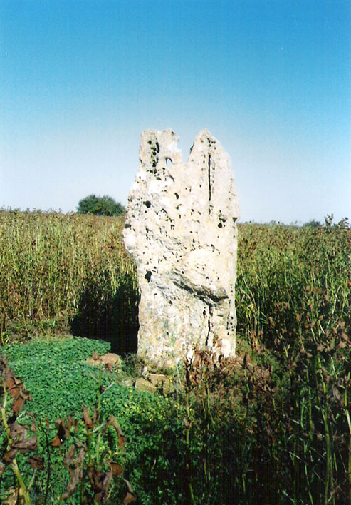
Go up Jura’s only road until it becomes a dirt-track and head along the track to the east to the natural hillock on the coast.  You’ll pass the three standing stones of Knockrome before you get to this one, right by the end house.

Archaeology & History

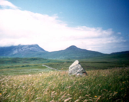
Found in a beautiful setting, this is a thick little stone but is less than four feet tall and it may have had some shapely relationship with one of the hills (Corra Bheinn) on Jura.  The Royal Commission (1984) described it merely as, “an erratic boulder measuring 3.1m in girth at the base, and 1.2m in height with its longer axis aligned roughly east and west.”  Several other stones can be found nearby.

References:

  1. Royal Commission on the Ancient & Historical Monuments of Scotland, Argyll – volume 5: Islay, Jura, Colonsay and Oronsay, HMSO: Edinburgh 1984.

© Paul Bennett, The Northern Antiquarian

Hawk Stone, Spelsbury, Oxfordshire

Standing Stone:  OS Grid Reference – SP 33923 23544

Getting Here

Hawk Stone on 1885 map

Best visited out of season before the corn’s been planted. It makes it  easier to find and doesn’t annoy the land-owner here, who tends to be a decent dood.  From Chipping Norton go southeast along the B2046 road to Charlbury.  After about 1½ miles take the second right turning down the small country lane.  Go slowly down here for less than half a mile, watching the fields on your right.  You’re damn close!

Archaeology & History

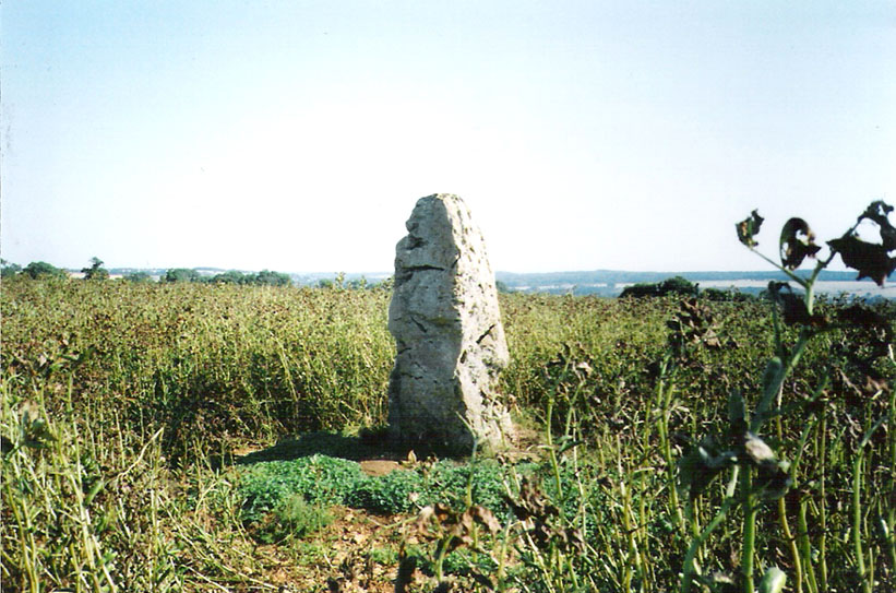
The Hawk Stone

This impressive, weather-worn, eight-foot tall standing stone stands aloft in the middle of a field due west of the road between Chalford Green and Dean.  It’s an excellent monolith and one which, I think, has a lot more occult history known of it than described here.  Thought by O.G.S. Crawford (1925) and others in the past to have been “formerly part of a chambered structure,”  or prehistoric chambered tomb like that of the Hoar Stone at nearby Enstone, no remains of such a structure unfortunately remain today.  It is first illustrated and named on a local map of the region in 1743 CE, and the stone at least has fortunately managed to escape the intense agricultural ravages endemic to this part of the country.

The name “Hawk” stone has been fancied by some to relate to some obscure resemblence to a Hawk, or because there very often are hawks hovering over those upland fields – but these are unlikely.  It’s thought by place-name authorities more likely to derive from a corruption of ‘Hoar’ meaning a grey or boundary stone; and as it stands just yards east of the present township boundary line, this derivation seems more probable.

To all lovers of megalithic sites, we highly recommend a visit here!

Folklore

In local folklore and in the opinion of some earlier historians, the Hawk Stone formed an integral part of a stone circle here, but there is little known evidence to substantiate this.

Hawk Stone in summer
Hawk Stone in winter

A creation legend attached to this site tells that the stone was thrown, or dragged across the land, by a old witch or hag — though we are not told from where.  This is a motif found at megalithic sites all across the country (see Bord & Bord 1977; Grinsell 1976, etc).  In Corbett’s History of Spelsbury (1962) the author told of the folklore spoken of by one Mr Caleb Lainchbury who

“said the cleft at the top of the Hawk Stone at Dean was supposed to of been made by the chains of the witches who were tied to it and burnt. As witches seem to have been extremely rare in Oxfordshire it cannot have been a very common practise to burn them at Dean; but there may indeed have been some kind of fire ceremonies near the stone.”

Grinsell (1976) also tells how the Hawk Stone has that animistic property, bestowed upon other old monoliths, of coming to life and going “down to the water to drink when it hears the clock strike 12.”

This evidently important and visually impressive monolith also plays an important part in an incredibly precise alignment (ley) running roughly east-west across the landscape.  At first, Tom Wilson (1999) thought the alignment had previously gone unnoticed, but later we later found a reference to the same line in an early copy of The Ley Hunter (Cooper 1979). It links up with other important megalithic sites, such as the Hoar Stones at Enstone, Buswell’s thicket, and the ancient Sarsden Cross.

Similarly, when Tom Graves’ (1980) was doing some dowsing experiments at the Rollright stone circle a few miles west, he found what he described as an ‘overground’ (or ley) linking the ring of stones to the Hawk Stone, but no other connecting sites are known along this line.

References:

  1. Bennett, Paul & Wilson, Tom, The Old Stones of Rollright and District, Cockley: London 1999.
  2. Bord, Janet & Colin, The Secret Country, BCA: London 1977.
  3. Cooper, Roy, “Some Oxfordshire Leys,” in The Ley Hunter, 86, 1979.
  4. Corbett, Elsie, A History of Spelsbury, Cheney & Sons: Banbury 1962.
  5. Crawford, O.G.S., The Long Barrows of the Cotswolds, John Bellows: Gloucester 1925.
  6. Gelling, Margaret, The Place-Names of Oxfordshire – volume 2, Cambridge University Press 1954.
  7. Graves, Tom, Needles of Stone, Granada: London 1980.
  8. Grinsell, L.V., Folklore of Prehistoric Sites in Britain, David & Charles: Newton Abbot 1976.

© Paul Bennett, The Northern Antiquarian 

Goff Well, Keighley, West Yorkshire

Healing Well:  OS Grid Reference – SE 06149 38822

Getting Here

Goff Well is by the Elder tree in the middle

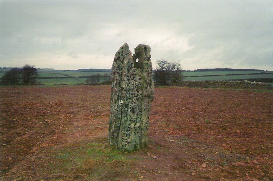
Various ways here. From Keighley, go up the A629 Halifax Road, first left after the Ingrow West train station, uphill; then turn right, and up the long, cobbled, zizaggy road past the little hamlet of Hainworth and uphill till you reach the solitary farmhouse of Goff Well Farm (where its friendly owners can sell you organic fresh eggs!).  It’s the field just before here on your left (if you reach the Guide Inn pub further uphill by the crossroads, you’ve gone too far). Alternatively start at the Guide Inn pub and walk across the road and downhill till you reach the farm. It’s in the first field on the right just past it.

Archaeology & History

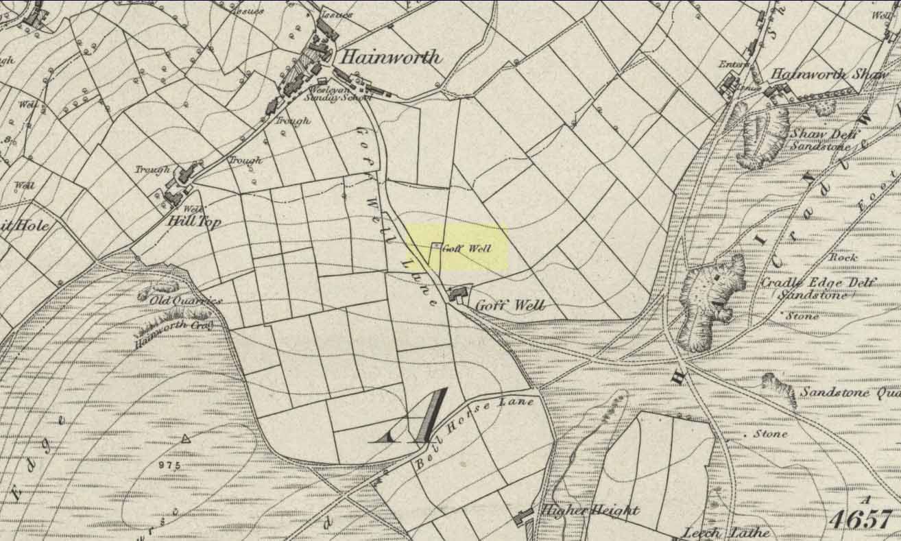
Little is known about the history of this water source.  The first description of it seems to be in 1852.  Harry Speight (1898) mentions it briefly when he talks about the holy wells of the locale, saying simply:

“Goff Well, close to the road on Harden Moor leading to Hainworth, has given name to a neighbouring farm, but the purpose or virtues of this water are not now known.”

Goff Well on 1852 OS-map

Today the well is much overgrown and in need of attention.  It’s near the bottom corner of the field where the larger of the elder tree grows (the witch’s tree par excellence) and could do with being cleaned out.  When the owner of Goff Well Farm, Barry, took us to see the site, the waters couldn’t be seen but we could hear the water running clearly just beneath the surface, so it just needs a few hours work to bring it back into life.  Twouldst do the land and the genius loci the world of good!

The very name of the well is something of an anomaly.  There are several possibilities and we (as yet) cannot say which is the more likely derivation.  We know in northern dialect that Goff is a simpleton or fool, and although we can apply that definition in some cases, it’s unlikely to apply here.  If we could ascertain there was ever an apple tree growing here, the mystery would be solved, as a goff was an old word used for the common apple.  In West Yorkshire dialect the word was also used to denote “a hammer worked by water-power”; aswell as it being a corrupted form of the word ‘God.’  Take your pick!

Folklore

The early Victorian historian William Keighley (1858) thought Goff Well was named after a long-forgotten hermit called Goff who, at some time in the past, gave his name to the old hamlet of Hermit Hole, a half-mile downhill from this water source.  Mr Keighley wrote:

“On the skirts of Harden Moor is a farmhouse known by the name of Goff Well; and as goff is said to be the Danish word for red, it would probably be no great stretch of the imagination to suppose that the hermit was so named on account of his red hair, and the spring or well designated after him from the frequency and sanctimonious nature of his visits.”

But this is pure supposition on Keighley’s part — nice idea though it is!  The only tangible piece of folklore we have is that the well “was a famous resort of gypsies before the moor was enclosed in 1861.” (Speight 1898)

References:

  1. Keighley, William, Keighley, Past and Present, Arthur Hall: London 1858.
  2. Speight, Harry, Chronicles and Stories of Old Bingley, Elliott Stock: London 1898.

© Paul Bennett, The Northern Antiquarian

Thor Stone, Taston, Oxfordshire

Standing Stone:  OS Grid Reference – SP 3592 2208

Also Known as:

  1. Thunor’s Stone

Getting Here

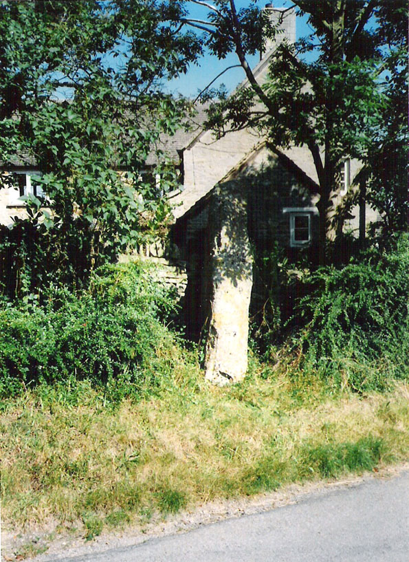
Thor Stone, Taston, hiding in shadows on bright sunny day

Very easy! From which ever direction you approach the gorgeous little village of Taston, get to the Cross in the middle of the road and look up the slight hill and at the old walling on the right-hand side.  You can’t really miss it!

Archaeology & History

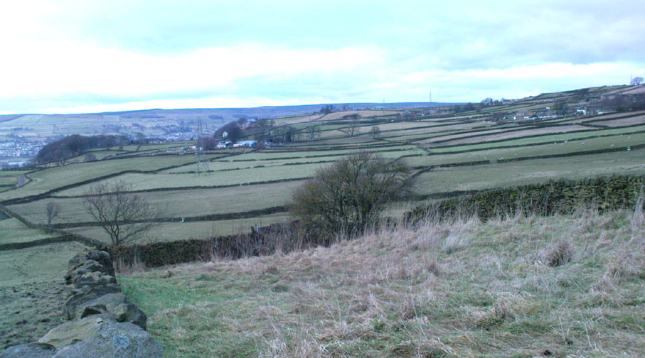
An impressive seven-foot tall standing stone resting up against the walling of Martin and Martha’s Thorstone Cottage, and which appears to have been recorded as far back as the late thirteenth century in the survey of the Chadlington hundred.  Indeed, according to the respective place-name authorities, the village of Taston itself appears to get its name from the Thor Stone, as it’s recorded as Thorstan in 1278 CE. (Gelling 1954)

Less than 100 yards away is a large old stone cross, the top of it now fallen, which may once have had some earlier pre-christian relationship with the Thor Stone; perhaps originating from other standing stones close by our now solitary Thor Stone (see Folklore, below).  No other monoliths or prehistoric tombs are presently associated with this site, but its folklore tells of earlier companions…

More than a hundred miles north of here we find an etymological sister in the old village of Thurstaston and where, not surprisingly, we have another Thor’s Stone — but in this instance the name applies to a huge rock outcrop with old pagan legends attached.

Folklore

Elsie Corbett (1962) tells that the creation myth for this stone was that it originated after the great god Thor cast a thunderbolt down from the heavens and this stone appeared as a result.  But more intriguing from an archaeological perspective is what Mike Howard (he of The Cauldron magazine) told us in a short article for the Gloucester Earth Mysteries magazine in 1994, which said that our grand old Thor Stone was once part of a stone circle.  He wrote:

“At Taston…are the rather battered remains of a megalithic circle known locally as the Thor Stones. It seems the original circle was dug up many years ago and the stones now reside in a neat pile at the crossroads in the centre of the village. The whole edifice resembles nothing less than an eccentric market cross, topped by a phallic stone.”

Although he doesn’t cite any sources for this bit of info (where’d you gerrit from Mike?), we need to take a more careful look at the old cross nearby.  And we find another piece of folklore relating to the Taston cross which said that it was placed there to abate the evil influences that were supposed to come from the Thor Stone.  This piece of folklore is simply one laid down by the Church which portrayed most things it did not understand, or sought to repress, as being the work of their own demonic power, Satan.

Between these two old monuments was once a huge old elm tree which, says Caroline Pumphrey (1990), was a meeting place of the local villagers in times gone by.  Whether this implies the Thor Stone to have been a moot spot is difficult to tell, although the erection of the cross would seem to add weight to this.

More recent screwy notions comes from one woman who reckoned, curiously, that the Thorstone got its name from some completely invented made-up goddess, saying:

“I believe its more likely to be a corruption of the name of ‘Hoar’, the great Goddess. Indeed the Hawk Stone, and various Hoar stones stand widely hereabouts and probably derived their names from the same deity.”

Utter drivel of course (there’s no such goddess as Hoar)! But — like the christians and others before them — people believe what they want to believe and this sorta nonsense is increasingly found all over the internet.  As is well known, the word hoar derives from ‘har’, being ‘grey’ or ‘a boundary’ (Gelling, 1954; Smith 1956); and numerous studies show this quite clearly.

References:

  1. Bennett, Paul & Wilson, Tom, The Old Stones of Rollright and District, Cockley: London 1999.
  2. Corbett, Elsie, A History of Spelsbury, Cheney & Sons: Banbury 1962.
  3. Gelling, Margaret, The Place-Names of Oxfordshire – volume 2, Cambridge University Press 1954.
  4. Grigson, Geoffrey, The Shell Country Book, George Rainbird: London 1962.
  5. Howard, Mike, ‘From Thor to Rollright,’ in Gloucestershire Earth Mysteries 18, 1994.
  6. Pumphrey, Caroline, Charlbury of our Childhood, Sessions Book: York 1984.
  7. Smith, A.H., English Place-Name Elements – volume 1, Cambridge University Press 1956.

© Paul Bennett, The Northern Antiquarian