Enclosure: OS Grid Reference – NN 5235 3684
Also Known as:
- Tirai West
- Tullich East
- Canmore ID 78043

Go through Killin past the Bridge of Lochay pub, turning immediately down the small lane by its side. After about 3 miles you’ll cross over the small river past Duncroisk. Keep going for another few hundred yards (if you reach Tullich you’ve gone too far), watching out for the gate on your left. Walk up to the top of this field, over the wall and up again. You’ll see a couple of tall trees with distinctive walling next to them, just on a ridge above you. That’s where you’re heading!
Archaeology & History
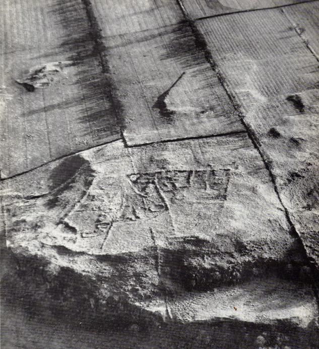
This is a fine-looking example of a prehistoric enclosure, perched on the edge of one of the grassy knolls on the far western extremities of the deserted village of Tirai. If you walk towards it from the derelict village east of here, the elliptical form of the site gives you the distinct impression that you’ve just chanced upon a seemingly unknown stone circle nestled upon the edges of this gorgeous Scottish glen; but this initial excitement is soon dispelled once you get into the heart of the site!


Although you’ll find a couple of derelict post-medieval buildings on the western side of this structure, the lay-out of this monument would seem to be Iron Age origin, perhaps earlier. It certainly has all the hallmarks of a walled structure from that period and typifies many others that I’ve explored down the years.
The eastern and southern sections of the walls are in very good states of preservation, although the ground has obviously grown up and around the bases of the stonework. It has a total outer circumferences of about 95 yards (87m), with the many upright stones measuring between 12 inches to more than 3 feet in height. The western section of the enclosure is mostly overgrown but easily traced on foot. Near the centre of the site is a large flattish stone that gave the impression of having an oratory function from where one could speak to the rest of the people sat around the inner edges of the enclosure — but this was a purely subjective impression.


On the southern side of the elliptical structure is another, outer line of walling, or a stone alignment of some sort just a few yards long, consisting of just a few upright stones — one of which stands considerably taller than all the others hereby, giving the impression of a standing stone. It has a large natural cup-marking on its southern face.
To my limited knowledge there’s been no excavations here, so one wonders whether or how or if the people of Tirai made use of this much earlier building. The Canmore entry of the place tells:
“The N side of this enclosure is a low turf and stone bank of height 0.3m and is 20m long, spread to about 1.2m. The E side is outlined by large stones set on edge with no evidence of intermediate stone walling or turf. A bank of similar more continuous stone extends to the W from the S of the main enclosure down sloping ground. This type of walling is different from any other on Tirai. The large stones set on end have suggested a prehistoric date for this enclosure.”
References:
- Johnstone, A. & Wood, S., “Tirai (Killin Parish), Pre-Enclosure Settlements,” in Discovery & Excavation in Scotland, 1990.
© Paul Bennett, The Northern Antiquarian