From Cow & Calf Hotel head onto the moor above you, following the same directions to reach the ornately carved Idol Stone (and its immediate companions). Ahead of you on the same footpath, about 100 yards along, as it begins to slope up the hill further onto the moor, you’ll see a large upright pyramid-shaped stone, about 8 feet all, right at the side of the path. Y’ can’t miss it!
Archaeology & History
Deep cups & lines on top
Although ascribed as a cup-marked stone in usual surveys, the cup-markings on top of this rock are seemingly Nature’s handiwork. There is a possibility that cup-markings were carved into the top of the stone, many thousands of years ago, but due to the centuries of wind and weathering, we cannot in anyway assess the curvaceous bowls and lines running across and from the top of this rock to be artificial.
Folklore
The name ‘Idol Stone’ seems to have come about as a result of the judaeo-christian Victorian obsession of satanic idolatry in all things natural – which many of them still fear. Sadly there are no early accounts of practices of idolatry at this rock, until it was used by chaos magickians in the formative years of that Current in the 1980s.
References:
Bennett, Paul, The Old Stones of Elmet, Capall Bann: Milverton 2001.
Boughey, K.J.S. & Vickerman, E.A., Prehistoric Rock Art of the West Riding, WYAS: Leeds 2003.
Forrest, C. & Grainge, William, A Ramble on Rumbald’s Moor, among the Dwellings, Cairns and Circles of the Ancient Britons, W.T. Lamb: Wakefield 1868-9.
Hedges, John (ed), The Carved Rocks on Rombald’s Moor, WYMCC: Wakefield 1986.
Holmes, J., “A Sketch of the Prehistoric Remains of Rombald’s Moor,” in Proceedings of the Yorkshire Geological Society, volume 9, 1887.
Speight, Harry, Upper Wharfedale, Elliott Stock: London 1900.
An impressive prehistoric cairn of some considerable size was in evidence on the lands of Old Sauchie, near Sauchie farmhouse, until the Industrial Age brought an end to its presence. First mentioned in the New Statistical Account (‘Stirlingshire’, volume 7), the Royal Commission lads reported,
“Nothing now remains of the cairn that once existed ‘on the lands of Sauchie’, about 3 miles SSW of Stirling. It was examined in the early 19th century and is said to have measured more than 20ft in height and 90ft in diameter, to have been made of stones, and to have contained two cists, one somewhat larger than the other. It is possible that Wilson (1863) is referring to this cairn when he mentions a quantity of ‘silver coins recently found in a cist exposed on the demolition of a cairn on the lands of Sauchie.’ The coins were very thin, and were described as having been ‘struck through from the back,’ with ‘figures’ on one side only. Some of them had loops for suspension, and there can be little doubt that they were silver bracteates. All have been dispersed and lost.”
If anyone has further information about this obviously important and seemingly lost site, please let us know!
References:
Royal Commission on the Ancient & Historical Monuments, Scotland, Stirlingshire – volume 1, HMSO: Edinburgh 1963.
Wilson, Daniel, The Archaeology and Prehistoric Annals of Scotland – volume 2, Sutherland & Knox: Edinburgh 1863.
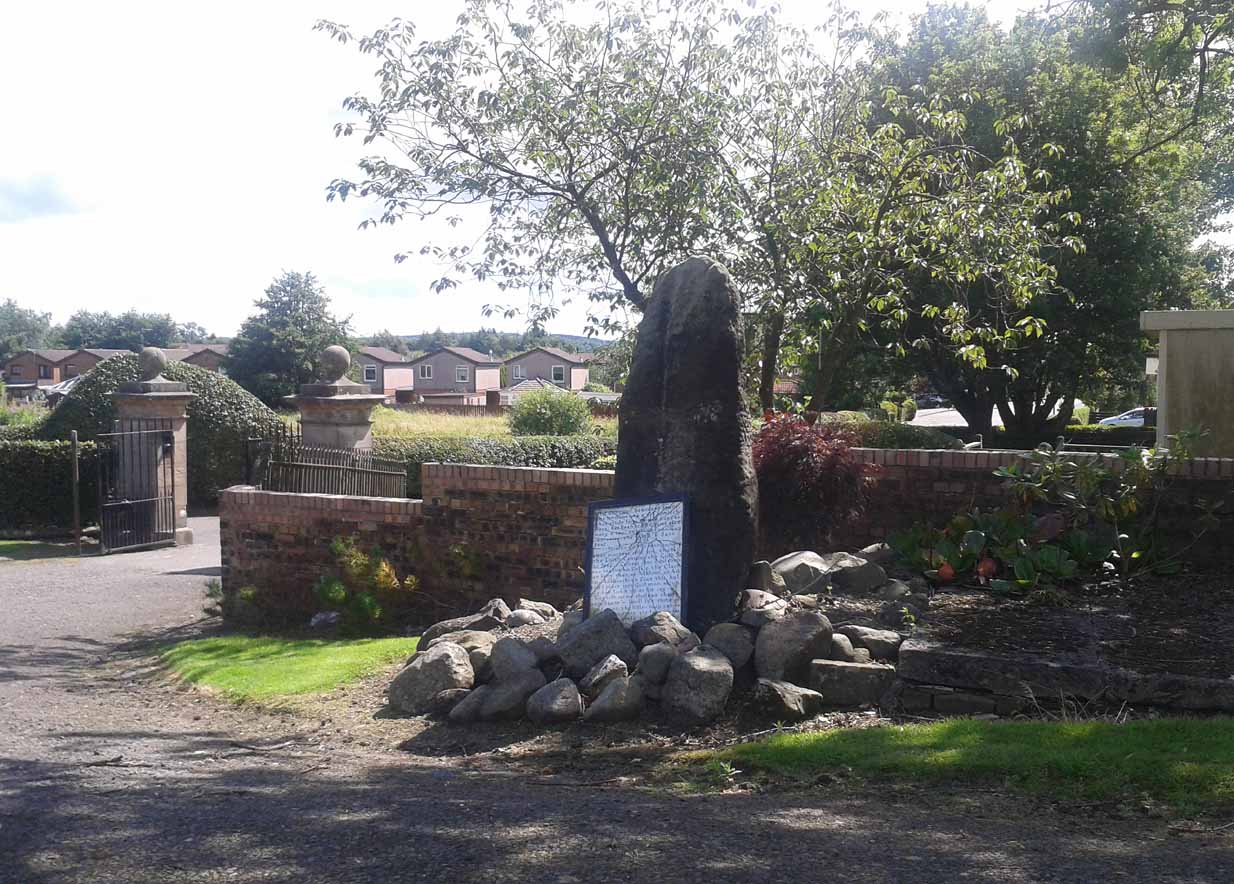
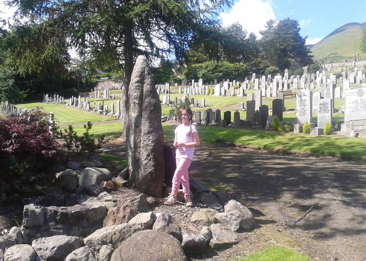
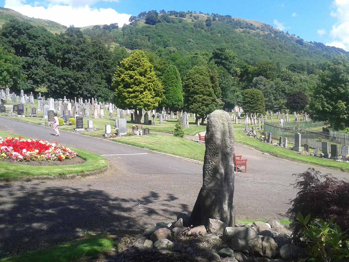
Go on the A91 through Alva, eastwards, and just before you go out of the town, note the small road on your left up to the graveyard. As you go into the graveyard, keep your eyes peeled on your left-hand side. You can’t really miss it!
Archaeology & History
Reported as “lost” or “destroyed” in many official reports, one of at least two standing stones that were reported in the Old Statistical Account of 1795 can still be found at the bottom of the graveyard, adjacent to the old holy well of St. Serf, at the edge of Alva town Very little has been written about it, and when it was mentioned in the OSA, the stones were only added in a foot note to the impressive stone cross on the outskirts of Alloa, saying:
“There are two stones resembling this one, in the neighbouring parish of Alva, at no great distance from the church, but not close to one another. They are both near the foot of the Ochils.”
A little person by its sideFrom the stone, looking NE
When some of the lads from the Scottish Royal Commission came here in July 1927, they could find no remains of any such standing stones and simply reported that they “no longer exist.” However, as visitors can plainly see, a tall upright standing stone still remains here, albeit repositioned by the good local people of Alva several decades ago. Standing more than seven-feet tall, the stone is very weather-worn on one side, with a plaque at the bottom.
References:
Royal Commission on the Ancient & Historical Monuments, Scotland, Inventory of Monuments and Constructions in the Counties of Fife, Kinross and Clackmannan, HMSO: Edinburgh 1933.
Follow the directions to reach the standing stone of Dunruchan D, and there on the moor immediately to your south, 100 yards or so away, it stands before you!
Archaeology & History
Dunruchan E stone, with Dunruchan D to rear
This is the southernmost of the impressive standing stones on the plain below Dunruchan Hill. Notably more ’rounded’ at the top than most of its associates—giving a more distinct ‘female’ nature to the stone than its companions—we find again, scattered around the base of this 7-foot tall monolith, a number of smaller rocks that gives the impression an old cairn was once here. Certainly there are a scatter of several other cairns nearby and we get the distinct impression with all of the Dunruchan stones, that a prehistoric cemetery was once in evidence here.
Ground-plan of stone & cairnCole’s drawing of Dunruchan E
Although this is the last of the known standing stones in this area, there is every probability of other prehistoric remains hidden amidst the heathlands—perhaps even more large standing stones that have fallen and are overgrown with vegetation. When Fred Cole came here one time with the great rock art writer, Sir James Simpson, one such fallen standing stone was reported a short distance tot he east, but it has yet to be recovered. There may be more.
In Fred Cole’s (1911) report of this particular “south stone”, or Dunruchan E, he wrote:
“This monolith, in respect of position, somewhat resembles the last, because it stands on the west arc of a rudely circular setting of small stones, which, however, are not placed on a mound (as in the case of Stone D), but merely lie on the flat of the moor. Five of these blocks are large enough to be noticeable, and they occupy the positions shown by the outlined stones in the ground-plan (fig. 21), the farthest to the east being 15 feet distant from the inner face of the standing monolith A. The dimensions of this Stone are: height 6 feet 9 inches, basal girth 16 feet 1 inch. In the illustration (fig. 22) I show this Stone with the other great one near set on its platform, and to the right two of the numerous small, low cairns which are scattered about this part of the moor. ”
Folklore
According to an account in the Ordnance Survey Name Book of 1860, “these stones are believed to mark the graves or commemorate the death of Roman soldiers who fell in a battle fought here between the Romans and the Caledonians.”
References:
Burl, Aubrey, From Carnac to Callanish, Yale University Press 1993.
Cole, Fred, “Report on Stone Circles in Perthshire, Principally Strathearn,” in Proceedings of the Society of Antiquaries, Scotland, volume 45, 1911.
Finlayson, Andrew, The Stones of Strathearn, One Tree Island: Comrie 2010.
Hunter, John, Chronicles of Strathearn, David Phillips: Crieff 1896.
Thom, A., Thom, A.S. & Burl, Aubrey, Stone Rows and Standing Stones – 2 volumes, BAR: Oxford 1990.
Up the B827 road (south) from Comrie, just follow the directions to reach the Craigneich standing stone, and from here go across the road and up the dirt-track past the Dunruchan B standing stone. Keep going further uphill, past the leaning Dunruchan C standing stone and onto the moorland plain just behind it. A few hundred yards in front of you you’ll see two large standing stones on the moor to the south. The nearest one is Dunruchan ‘D’.
Archaeology & History
Fred Coles’ 1911 drawing
Another fine large standing stone in this curious but excellent megalithic complex on the hills south of Comrie. This great monolith leans at a slight angle, and would be some 10 feet tall if the ages had kept it perpendicular. It’s truly impressive; and it emerges from the edge of a large raised cairn which almost surrounds it. The cairn is overgrown yet some 3-4 feet tall and made up of thousands of small stones. It’s the most notable of the cairns scattering the plains of Dunruchan, and gives the best impression of the standing stones here being memorials to some ancient chief, queen or shaman. As far as I know, this cairn has not been excavated, so we know not yet who or what lies beneath it.
Carved parallelogram
A small section of the standing stone has some faded carving on its eastern side. These seem to be relatively recent, though a curious parallelogram design echoes the carving (albeit larger) on the Gleneagles B standing stone, 10 miles southeast, and which is thought to be Pictish. The carving here, however, doesn’t have that feel to it.
The stone and the cairn were noted in Fred Coles’ (1911) survey, in which he called this the “south-west stone” and wrote:
“New features are presented in combination with this Stone. In lieu of being set absolutely solitary on the heath, there are, extending for a considerable area almost around its base, many stones and boulders laid in the form of a flattish circular cairn or platform (see ground-plan). The monolith, which leans over towards the north, is set to the south of the crest of the cairn, and there is a considerable fall from the crest to the level of the moor around it, indicating that a very great quantity of small stones must have been employed in making the cairn. The interior, shown dotted on the plan, bears signs of having been partially excavated, probably the cause of the Stone being so much out of the vertical. The stony cairn or platform measures 15 feet in diameter, and consists of moderate sized stones. The base of the great Standing Stone is oblong, and measures in girth 14 feet 2 inches. Down the slope of its back the length is 10 feet, and its present vertical height 8 feet 6 inches. The longer axis is almost exactly due east and west. From this spot the next Stone in order can be easily seen…”
Coles’ groundplan of cairn & stone
Several other small cairns scatter this grassy and heathland plain, all of them overgrown and none of them excavated.
Dunruchan D, looking south
As with the other Dunruchan monoliths, this one has been included in the megalithic stone row surveys by both Alexander Thom (1990) and Aubrey Burl (1993), but the staggered alignment this has with the other standing stones is more likely fortuitous than deliberate. But this doesn’t detract from the magnitude of the megalithic cluster on this small section of moorland. A truly brilliant site!
Folklore
According to an account in the Ordnance Survey Name Book of 1860, “these stones are believed to mark the graves or commemorate the death of Roman soldiers who fell in a battle fought here between the Romans and the Caledonians.”
References:
Burl, Aubrey, From Carnac to Callanish, Yale University Press 1993.
Cole, Fred, “Report on Stone Circles in Perthshire, Principally Strathearn,” in Proceedings of the Society of Antiquaries, Scotland, volume 45, 1911.
Finlayson, Andrew, The Stones of Strathearn, One Tree Island: Comrie 2010.
Hunter, John, Chronicles of Strathearn, David Phillips: Crieff 1896.
Thom, A., Thom, A.S. & Burl, Aubrey, Stone Rows and Standing Stones – 2 volumes, BAR: Oxford 1990.
Follow the directions to get to the Dunruchan B standing stone, on the slopes south of Craigneich. Once there, on the hillside further above you, you’ll see a large upright stone on the moor about 300 yards to the south, standing just below the rise of a small hillock. That’s it!
Archaeology & History
Fred Coles’ 1911 drawing
The second biggest of the Dunruchan monoliths is what Fred Coles (1911) described as “the Middle Stone,” or Dunruchan C. Standing just below the rise of a large natural mound of earth, obstructing any immediate view of the western hills, it too has a long upright shape with a pointed end to the stone, leaning at a considerable angle. The massive stone of Dunruchan A is clearly visible on the grassy cairn-scattered plain 543 yards to the east and the smaller Dunruchan B to the north on the slopes below. Dunruchan C was deemed as one of the central stones in this unlikely megalithic stone row by both Aubrey Burl (1993) and Alexander Thom (1990). Mr Coles’ description of the site told:
“This huge block…rugged and irregular…makes, from the extraordinary angle at which it leans over southwards, a surprisingly picturesque object amid the heather and the various small boulders that lie scattered about in its vicinity. Of oblong basal section, the Stone tapers sharply up to a small narrow edge, which is at present 9 feet 4 inches in vertical height above the grassy ledge surrounding the base. In girth it measures over 17 feet, and the slope of its upper surface is over 12 feet in length. Intervening undulations in the moorland prevent one seeing the two Stones which stand farther down south-wards. The main axis of its base is N. 18° W. by S. 18° E. ”
Dunruchan C, looking eastThe leaning pillar of Dunruchan C
Once you walk onto the mound above this stone, the landscape opens up all round you. The southernmost monoliths of the Dunruchan complex awake to the south; what seems to have been another significant boulder sits low down a few hundred yards to the west; the faint outline of a large man-made enclosure of some sort is another 100 yards west of that; and the rocky mountains west and north of here captures you with a relaxing exultation, typical of the Scottish hills. This arena is an absolute must for all megalith fanatics!
Folklore
According to an account in the Ordnance Survey Name Book of 1860, “these stones are believed to mark the graves or commemorate the death of Roman soldiers who fell in a battle fought here between the Romans and the Caledonians.”
References:
Burl, Aubrey, From Carnac to Callanish, Yale University Press 1993.
Cole, Fred, “Report on Stone Circles in Perthshire, Principally Strathearn,” in Proceedings of the Society of Antiquaries, Scotland, volume 45, 1911.
Finlayson, Andrew, The Stones of Strathearn, One Tree Island: Comrie 2010.
Hunter, John, Chronicles of Strathearn, David Phillips: Crieff 1896.
Thom, A., Thom, A.S. & Burl, Aubrey, Stone Rows and Standing Stones – 2 volumes, BAR: Oxford 1990.
Take the same directions as if you’re visiting the Dunruchan A standing stone, taking the small track up across the other side of the road from the Craigneich standing stone. As you walk up the field from the roadside, don’t go through the gate, but just walk straight uphill, following the fence through boggy & overgrown vegetation. When you get to where the hill starts to level out and the fence cuts across in front of you, notice the small standing stone on the other side of the fence, about one hundred yards up. That’s it!
Archaeology & History
Fred Coles’ 1911 drawing
This, the smallest of the six Dunruchan standing stones, is what Fred Coles (1911) described as “the North-West Stone,” or Dunruchan B. In size alone it has a very different character to the others on the hillside immediately above and almost seems out of character when compared to the rest. Standing amidst typical moorland vegetation, this pointed upright is more than five feet tall, and from here its huge companions can be seen rising from the Earth to both east and south. Coles’ description of this monolith was as follows:
“This block of conglomerate, not half the height of (Dunruchan A)…occupies a rather lower position 385 yards to the west. Its basal girth is 8 feet 10 inches and its height 5 feet 1 inch, the south being the smoothest of its four sides. It is not now quite vertical, having a lean to the south. Like the great North-east Stone, this one tapers to a rather fine point… From this Stone the other four in the group as well as that at Craigneich are visible. ”
Dunruchan B, looking NWDunruchan B, looking S
However, we couldn’t make out all the standing stones in this complex like Coles reported. The huge leaning monolith of Dunruchan C is the closest of the others from here and, perhaps, would be the reason the cluster have been added to the lists of megalithic stone rows by Burl (1993) and Thom (1990), as a spacious curved row geometrically links them together – but I’ve gotta say, I’m sceptical about this as a deliberate megalithic alignment. However, I’ve no doubt that Alfred Watkins and his fellow ley hunters would add this to their inventory of Perthshire ley lines.
Folklore
According to an account in the Ordnance Survey Name Book of 1860, “these stones are believed to mark the graves or commemorate the death of Roman soldiers who fell in a battle fought here between the Romans and the Caledonians.”
References:
Burl, Aubrey, From Carnac to Callanish, Yale University Press 1993.
Cole, Fred, “Report on Stone Circles in Perthshire, Principally Strathearn,” in Proceedings of the Society of Antiquaries, Scotland, volume 45, 1911.
Finlayson, Andrew, The Stones of Strathearn, One Tree Island: Comrie 2010.
Hunter, John, Chronicles of Strathearn, David Phillips: Crieff 1896.
Thom, A., Thom, A.S. & Burl, Aubrey, Stone Rows and Standing Stones – 2 volumes, BAR: Oxford 1990.
From Comrie town centre take the road south across Dalginross Bridge over the river, heading towards Braco, up the winding B827 road for 2-3 miles until you reach a small crossroads (you can easily miss it, so watch out!). Turn left and, about a mile on, 100 yards or so before Craigneich Farm (near its lovely standing stone), go up the track on your right up the hills. Follow the track up and through the gate, then walk straight uphill. A coupla hundred yards up you’ll see a large standing stone on the flat grassy plain to your left. That’s Dunruchan A.
Archaeology & History
Dunruchan A, looking east
This is a magnificent stone in a magnificent landscape, no doubt of considerable mythic importance to the people who lived and erected it several thousand years ago. It is the tallest of at least six standing stones to be seen on this section of moorland and stands out on the hillside from various angles as you walk the hills and glens around here: an element that was, no doubt, intended by those who built it. It’s probably a very old standing stone, more likely neolithic in origin than the generally ascribed Bronze Age.
The great stone in the skyDunruchan A, and its heathen onlooker
Standing on the flat grassy plain above Shillinghill and Craigneich, it is surrounded by many small cairns and, it would seem, was once accompanied by a cairn of its own if the scatter of small rocks around its base is anything to go by (though I’m not aware of any detailed excavations here by antiquarians, so this initial assumption may be wrong). Indeed, it seems the Dunruchan A stone stands in the middle of a scattered prehistoric cemetery if the many small overgrown piles of rocks are anything to go by: though I know of no detailed account of these many scatterings of stones (anyone know if they’re ancient, or field clearances?). However, the great megalith hunter Fred Coles (1911) did comment on how this and the other giant standing stones nearby may “commemorate burials,” but didn’t explore the idea any further.
Approaching twelve feet tall, it was Cole (1911) who described this huge standing stone in one of his essays on the Perthshire megaliths, telling:
“Dunruchan Moor stretches, at a general height of about 700 feet above sea-level, for nearly two miles towards the south and south-west of Craigneich. At its northern extremity, and distant from the Craigneich Stone about 610 yards, stands the first and the tallest of the group (A on the plan), a huge pointed mass of conglomerate schist, its apex being 11 feet 4 inches above ground. Its base is a somewhat regular oblong, measuring along the north and south faces 4 feet 2 inches, and across the edges 3 feet 10 inches and 2 feet 2 inches, the wider of these being on the east. Small and insignificant boulders lie loosely around it. The smoothest and most vertical side faces the north. The illustration (fig. 16A) was drawn from the east, with the Aberuchil Hills as a background.”
Fred Coles’ 1911 drawing
From this great stone, looking west across the moors the giant standing stone of Dunruchan C and its companions can be noticed just a few hundred yards away. A cup-marked stone can also be seen about 200 yards west of here. It has been suggested that this and the other standing stones were part of some curious megalithic stone row (Burl 1993; Thom 1990), but this seems most unlikely. Thom made no notes of the archaeoastronomical potential at Dunruchan A, nor its associates.
As a megalithic complex, this area is outstanding. The other large standing stones of Dunruchan D and Dunruchan E are on the moorland plain a few hundred yards to the southwest and must be visited if you explore the area. This is serious megalith country!
Folklore
According to an account in the Ordnance Survey Name Book of 1860, “these stones are believed to mark the graves or commemorate the death of Roman soldiers who fell in a battle fought here between the Romans and the Caledonians.”
References:
Burl, Aubrey, From Carnac to Callanish, Yale University Press 1993.
Cole, Fred, “Report on Stone Circles in Perthshire, Principally Strathearn,” in Proceedings of the Society of Antiquaries, Scotland, volume 45, 1911.
Finlayson, Andrew, The Stones of Strathearn, One Tree Island: Comrie 2010.
Hunter, John, Chronicles of Strathearn, David Phillips: Crieff 1896.
Thom, A., Thom, A.S. & Burl, Aubrey, Stone Rows and Standing Stones – 2 volumes, BAR: Oxford 1990.
ACKNOWLEDGEMENTS: Many thanks to Paul Hornby for use of his photos!
Cup-marked stone, with Dunruchan C standing stone on horizon
We parked-up by the small trackway into the fields on the opposite side of the road 100 yards short of Craigneich across from the standing stone, then walked up the track, thru the gate, then walked uphill. Tis boggy & bumpy as you’d expect – and then, as you espy the giant standing stones of Dunruchan on the ridges above, watch out for the large rounded boulder (amongst many) as you near the level 100 yards or so before the magnificent Dunruchan A stone. Look around!
Archaeology & History
Close-up of cup-marks
Not far from the cup-marked stones of Blar an Rodhar is what appears to be another such carving. Here, two archetypal cup-marks are clearly visible on one of the large rocks on the slope up to the huge standing stone of Dunruchan A. There may be other faint cup-marks on this boulder, but the light wasn’t too good when we first found this, so I’m not sure about any others. The main two however, as the photo shows, stand out! A grassy overgrown cairn is some 10 yards away to the east, almost in line with the largest Dunruchan Stone. The Dunruchan C standing stone is also clearly visible on the skyline to the west, leaning at an angle. Many other small cairns are scattered on the grassy plain where this cup-marked stone rests. The carving is not included on Canmore’s website, so this could be another new find. However, the rock up here aint what I’m used to – so if any local geologists or antiquarians can show me it’s Nature’s handiwork, please lemme know and I’ll delete it from the website.
* Grid-ref may need revising, as we went out without mapping instruments. If someone gets a better coordinate, please send it in.
From Comrie town centre take the road south across Dalginross Bridge over the river, heading towards Braco, up the winding B827 road for 2-3 miles until you reach a small crossroads (you can easily miss it, so watch out!). Turn left and, about a mile on, keep your eyes peeled – either for the standing stone in the field on your left, or the dirt-track to Craigneich Farm 100 yards further on.
Archaeology & History
…and again, looking east
This is a large standing stone in a truly beautiful setting. More than six-feet tall, it stands amidst a gorgeous atmosphere just off the quiet roadside and has been all-but neglected by most archaeological surveys. Thankfully it was one of the many impressive monoliths in this district that was described in one Fred Coles’ (1911) fine surveys. Described in conjunction with the even more massive standing stones on the slopes to the south, he told:
“This Stone is one mile and a furlong SSE of the last, on the north side of the road between Straid and Shillinghill, at 514 feet above sea-level. The locality lies to the north of Aodan Mohr, which is the name given to the upper portion of Dunruchan. .. Its base is of an extremely irregular four-sided shape, having a jutting-out ledge on the south (see drawing). In basal girth it measures 15 feet 9 inches, and in height 6 feet 4 inches. The longest axis points N. 33° E.. by S. 33° W .”
Craigneich stone (Coles 1911)
Others may have once stood in close attendance, as the Chronicles of Strathearn (1896) tells how at Blarinroar (the name of the fields here) there were standing stones twenty feet tall! Cole thinks this to be an error based on the megaliths of Dunruchan, half-a-mile to the south. On the other side of the road from here, in the hedgerow, lies a fallen stone covered in ages of moss.
The now singular upright has been linked, albeit tentatively, to the Dunruchan megaliths as part of a possible stone row (Burl 1993; Thom 1990), but this seems very unlikely.
In Edward Peterson’s (1996) survey of Pictish monuments, he thought the Craigneich stone may have been important to the Seal tribe in ages gone by, as he says there are some Pictish carvings on the stone:
“The heads of two seals are relatively clear, positioned near the centre of this stone. Not so clear is the head of a cat at the top right hand corner, and to the immediate left is another seal head. These are only a few of the animal heads appearing on this sea/seal-god standing stone.”
More antiquarian research is obviously required here. It’s a truly superb spot!
References:
Burl, Aubrey, From Carnac to Callanish, Yale University Press 1993.
Cole, Fred, “Report on Stone Circles in Perthshire, Principally Strathearn,” in Proceedings of the Society of Antiquaries, Scotland, volume 45, 1911.


")
")

")

")


")


")


")


")