Standing Stone (destroyed): OS Grid Reference – SE 299 612
Also Known as:
Temple Yarmer
Archaeology & History
It was the legendary Harry Speight who described this in his monumental historico-topographical exploration of the Nidd valley in the 1890s. Nothing else, it seems, has been said of the place, though something of considerable archaeological importance was once here. Not only does he tell of the previous existence of “a large circular enclosure…the outer ditch having a circumference of nearly 1000 yards” at Yarmer Head, but,
“In the hollow on the east side of this hill was formerly a large natural marsh or lakelet, near which remains the base of an immense menhir or standing monolith, erected doubtless in heathen days to commemorate a great victory, or perhaps a treaty.”
The stone is not shown on the early OS-maps (although they did miss quite a lot of sites), and whatever its reason for being here might never be known as all traces of this giant monolith appears (yet again) to have vanished. There is an ancient boundary line immediately below the hill, on its eastern side, so perhaps the stone was an ancient marker along this. Do any local folk round Nidd know owt more about this once important megalithic site?
References:
Speight, Harry, Nidderdale and the Garden of the Nidd, Elliot Stock: London 1894.
Stone Circle (destroyed): OS Grid Reference – NS 9256 9709
Also Known as:
Druidical Temple
Archaeology & History
A stone circle was once to be found on the elevated piece of ground above the north-side of the main road between Tillicoultry and Dollar, but it was sadly destroyed sometime in the 19th century. Listed in Aubrey Burl’s (2000) magnum opus, we have very little information about the place; though an account of the site was described in the Scottish Royal Commission report (1933) which told us that a —
“Stone circle, measuring about 60 feet in diameter, once stood here but was completely removed many years ago, when the stones, which are said to have been 5½ feet in average height, were taken to cover a built drain at Tillicoultry House”!
Site shown on 1866 OS-mapStone at the destroyed site
Unbelievable! Any decent local folk nearby wanna find out where this drain is, see if the stones are visible (though I doubt they are), so we can plan to uproot it and move the stones back somewhere nearby. There are a few decent spots on the slopes above where it would look good!
When visited by researchers in the 1890s, parts of an embankment which surrounded the destroyed circle were still visible. Also, indicating there was some ritual funerary nature to the site, a local teacher called Mr Christie found the remains of an ornamented urn protruding through the ground next to where one of the monoliths had stood. Unfortunately in his attempts to remove the urn, much of it crumbled away.
Further examinations thereafter found that a burial was (seemingly) beneath the centre of the circle; and excavations here found that a covering stone of the tomb was covered in intricate cup-and-ring designs (see the Tillicoultry House Carving for further details). Other prehistoric remains were found a little further up the hill from here.
References:
Burl, Aubrey, The Stone Circles of Britain, Ireland and Brittany, Yale University Press 2000.
Morris, Ronald W.B., The Prehistoric Rock Art of Southern Scotland, BAR 86: Oxford 1981.
Robertson, R., ‘Notice of the Discovery of a Stone Cist and Urns at the Cuninghar, Tillicoultry…’, in PSAS 29, 1895.
Royal Commission on the Ancient & Historical Monuments of Scotland, Fife, Kinross and Clackmannan, HMSO: Edinburgh 1933.
Standing Stone (destroyed?): OS Grid Reference – SE 1765 5032
Archaeology & History
Eric Cowling (1946) described this lost or destroyed stone as “a squat standing stone at junction of the Askwith bridge-path with the Otley-Timble highway, saying how it gave its name to Stoop Hill, “which it surmounts.” But in several ambles here in search of this old stone, we’ve yet to locate it; though we did find the Stoup Hill cup-marking and possible neighbour on the southern edge of the hilltop.
Folklore
In days of olde, the ‘Old Man’ was the fabled companion of the legendary ‘Old Woman,’ or great cailleach (the christian cult stupidly, somehow, turned this mythic figure into their ‘devil’ – to which it has no relationship whatsoever). Although no specific folktale remains here, the name of this lost stone tells that it had some mythic tale underscoring it; perhaps simply that it marked the burial of some forgotten chief or elder.
From Threshfield, go up Skirethorns Lane for about 1/2 mile, where the lane takes a sharp right. Continue uphill for nearly 2 miles to a metal gate. Go through the gate, where you’ll see a pair of curious standing stones ahead of you, but instead walk about 250 yards along the line of the old field wall running to the west. You’ll see on the modern OS-map that a ‘cairn’ is shown: this is where you’re heading!
Archaeology & History
First highlighted on the 1852 OS-map of Bordley and district, this is a lovely site in a beautiful setting, surrounded by a veritable mass of other prehistoric remains at all quarters, including the large settlement of Hammond Close immediately south, the little-known settlement at Kealcup to the west, the Lantern Holes settlement up the hill immediately north, some standing stones due east, and much more. Although it was described in Aubrey Burl’s Four Posters (1988) as just such a type of megalithic relic (a “four-poster stone circle”), an earlier description of the site from the mighty pen of Harry Speight (1892) told of a much more complete ring of stones, with trilithon to boot. He wrote:
“This prehistoric relic consists of a round stone and earthen mound, about 150 feet in circumference and 3 feet high, and was formerly surrounded by a circle of upright stones, only three of which are now left standing. On one side was a large flat stone resting upon two others, and known as the Druid’s Altar. On the adjoining land an ancient iron spear-head was found some years ago, and fragments of rudely-fashioned pottery have also from time to time turned up in the same neighbourhood.”
Edmund Bogg’s (1904) description following his own visit a few years later described this “remains of Druidical sacrifice” as consisting of,
“a mound some four feet high, and fifty yards round the outer rim. In the centre are two upright stones about four feet in length; and others nearly buried in the mound. Numerous stones from this circle have been used in building the adjoining walls.”
Bordley Circle, looking SEBordley Hill, looking south to Pendle Hill
A decade later another writer (Lewis 1914) merely copied what Speight and Bogg had recited previously. And whatever the modern books might tell of its status, I think we can safely assert that this was originally a much more substantial monument than the humble four-poster stone circle that meets our eye nowadays. Our megalithic magus, Aubrey Burl (1988), wrote the following on Bordley’s druidical stones:
“On a circular mound 41ft (12.5m) across and 3ft (1m) high, three stones of local limestone form the corners of a rectangle 11ft 6in (3.5m) square, from which the SW stone is missing. At its corner is ‘a stump, possibly the base of a prostrate stone,’ 5ft 10in (1.8m) long, now lying near the centre. The tallest stone, 3ft 7in (1.1m) high is at the south-east. The sides of the square are close to the cardinal points. Between the SW and SE stones is a scatter of round cairnstones… Characteristically, the 4-Poster stands at the edge of a terrace from which the lands falls steeply to the west.”
Plan of the Druid’s Altar (after Burl, 1988)
The Druid’s Altar seems to have originally been a large prehistoric tomb, perhaps even a chambered cairn. Its situation in the landscape where it holds a circle of many outlying hills to attention, almost in the centre of them all, was evidently of some importance. The only geographical ‘opening’ from here is to the south, where a long open valley widens to capture the grandeur of Pendle Hill, many miles away. This would not have been insignificant.
We must also draw attention to what may be a secondary tumulus of similar size and form to the mound that the Druid’s Altar sits upon only some 25 yards to the west of the “circle”. The shape and form of this second mound is similar to that of our Druid’s Circle — though to date, it seems that no archaeologist has paid attention to this secondary feature. It measures some 21 yards (east-west) x 19 yards (north-south) in diameter and has the appearance of a tumulus or buried cairn. The mound may be of a purely geological nature, but this cannot safely be asserted until the attention of the spade has been brought here.
Druid’s Altar, Bordley (drawing by Neil Wingate, 1976)
Folklore
Although we have nothing directly associated with the circle, the surrounding hills here have long been known as the abode of faerie-folk. Threshfield — in whose parish this circle lies — is renowned for it. There have been accounts of curious light phenomena here too. Modern alignment lore tells the site to be related to the peaked tomb above Seaty Hill, equinox west of here.
References:
Bogg, Edmund, Higher Wharfeland, James Miles: Otley 1904.
Burl, Aubrey, Four Posters: Bronze Age Stone Circles of Western Europe, BAR 195: Oxford 1988.
Feather, S.W. & Manby, T.G., ‘Prehistoric Chambered Tombs of the Pennines,’ in Yorkshire Archaeological Journal, Vol 42, 1970.
Lewis, A.L., ‘Standing Stones and Stone Circles in Yorkshire,’ in Man, no.83, 1914.
Raistrick, Arthur, ‘The Bronze Age in West Yorkshire,’ in Yorkshire Archaeological Journal, Vol 29, 1929.
Speight, Harry, The Craven and Northwest Yorkshire Highlands, Elliott Stock: London 1892.
Wingate, Neil, Grassington and Wharfedale, Grassington 1977.
Takes a bitta getting to this one, right at the far end of the road, leading to nowhere – so those of us who like Scotland for its vast expanses of ‘middle o’ nowhere’ should like it! From Port Ellen, travel along the A846 eastwards, all the way to the where it ends in Ardbeg. But the smaller track road continues up the coast. Keep going – and keep going all the way up; past the ‘stone circle’ of Ardilistry, past the standing stone of Trudernish, right to the very end where the track leads you to the farmhouse of Ardtalla. Once here, you’ll see the stone about 20 yards west of the farm.
Archaeology & History
This old stone is only 4-foot-tall, leaning slightly, but—as I recall from many years back—”it’s cute!” (sad aren’t I?!) All the way up here to see a small monolith! Even the Royal Commission (1984) lads didn’t have much to say about it, merely:
“This standing stone is situated 18m NW of the SW gable of Ardtalla farmhouse. Leaning slightly to the SSE, it measures 0.48m by 0.48m at the base and 1.25m in height.”
But if you like walking, the rest of the route up the coast is excellent. Stick yer tent in the small woodland by the fort a mile or two further north, then bring your attention to the legendary Beinn na Cailleach, if the heathen within you stirs…
References:
Royal Commission on the Ancient & Historical Monuments of Scotland, Argyll – volume 5: Islay, Jura, Colonsay and Oronsay, HMSO: Edinburgh 1984.
Stone Circle (destroyed): OS Grid Reference – SD 822 387
Also Known as:
Pendle Stone Circle
Archaeology & History
A destroyed site mentioned by several local historians. It was positioned at the valley bottom just below Faughs, a hundred yards west of Lower Moss End, where today it is simply overgrown meadows with the typical excess of Juncus reeds. As local investigator John Dixon said, there are “five stones shown on (the 1848) map just west of Spen Brook Mill.”
In the 1970s, one writer described there being several uprights still in place, but a visit here a few weeks back (though I – unusually! – didn’t walk all through the boggy grounds and explore as extensively as I normally would) found nothing.
Its geomancy, however, was striking. The unnamed hill immediately to the north of its position (at the southern end of the legendary Pendle Hill, a coupla hundred yards west of St. Mary’s church) rises up like a great singular ‘pap’ which, to our old ancestors, was animated with female spirit. I sat here in the pouring rain looking up at this hill and its presence in front of the circle was striking.
…And so I walked onto the top of the said hill. Thereupon I found a small gathering of rocks, not unlike a cairn-spoil. When I enquired with a few local people about the age or nature of this rock-pile, I found no-one seemed aware of its existence. Weird. But from the hill itself, the view is excellent – and the small valley amidst which the old circle once stood teems with legends and myth: of cailleachs, ghosts, wells, witches and more. An excellent spot!
The local writer, historian and walker, John Dixon, sent us the following notes of his exploration here:
“Clifford Byrne, the late Nelson antiquarian, mentions in his book ‘Newchurch in Pendle’ the site of a former stone circle that stood just below Faughs, a hundred yards west of Lower Moss End. Today no large stones of any kind can be located anywhere near this spot, the stones having been removed or broken up some time in the past. However, the 1848 6” OS map records the number and position of these stones as being in two parallel lines about a hundred yards apart lined up west to east. The northerly line (SD 823 389) consists of 3 stones, the southerly (SD 823 387) of 4 stones, all being some 3 yards apart.
“It appears that we have an avenue of stones, not a circle. But why their position in the landscape at the headwaters of two valley streams? The Sabden Brook starts its journey westward to meet with the Calder from the stones, while Dimpenley Clough rises from the stones running east to join Pendle Water – could this be of any significance?”
References:
Byrne, Clifford, Newchurch-in-Pendle: Folklore, Fact, Fancy, Legends and Traditions, Marsden Antiquarians: Nelson 1982.
One of two ways to get here really. The easiest is from Sutton-in-Craven: go through the village and up the steep hill (don’t take the right turn as you start up the hill). Go all the way up until the hill starts to level out and on the left-side of the road you’ll notice a boundary stone stood upright (this is the Sutton Stoop). Stop here. Of the 2 gates, climb over the top-most one and walk down the path into the adjacent field, heading over to the gap a couple of hundred yards away where the gate to another field is. That’s it!
Archaeology & History
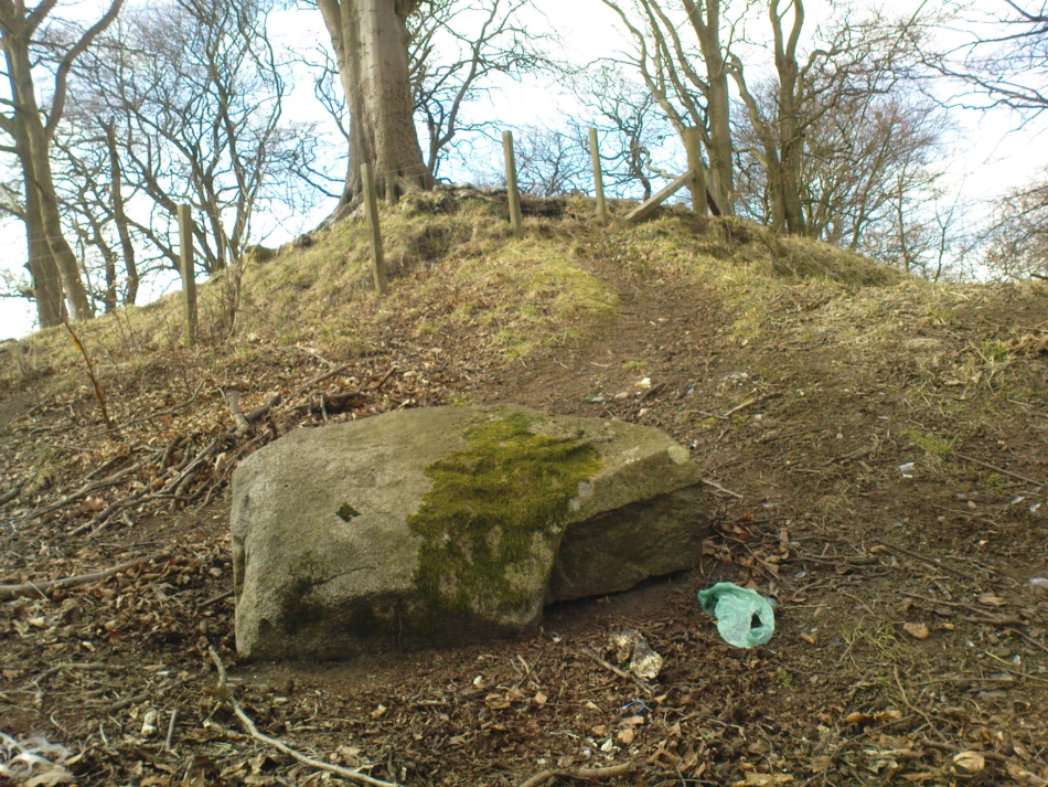
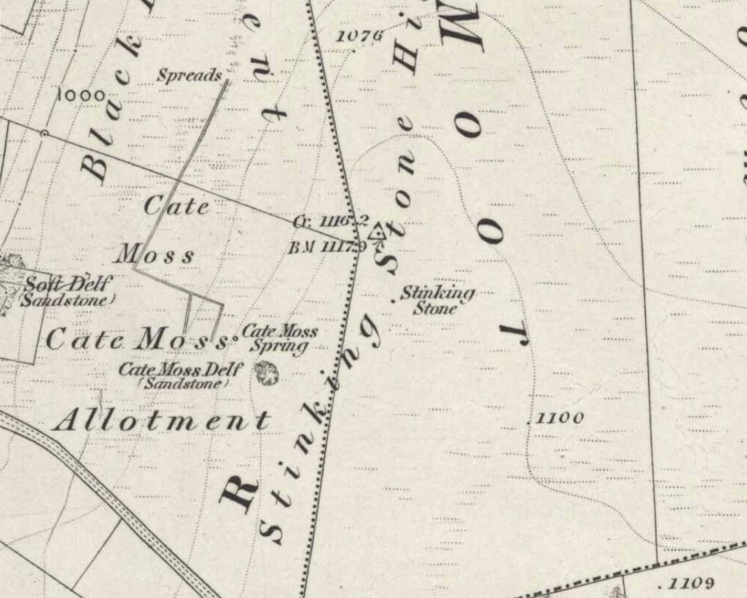
Stinking Stone, Steeton
Now here’s a weird one. With a name like this you’d expect there to be plenty of info or historical comments. But despite all the books and journals in my huge library, aswell as visiting town libraries and exploring the resources on-line, there’s nowt written about this ‘ere spot. Not a jot! Even the usually satisfactory place-name fellas have a thing-or-two to say about sites with names such as this—but even their old tomes are closed-lipped. Hmmmmm…..
I visited the place several times to try ascertain what this site was, thinking — perhaps — that it was an old boundary stone whose name had been convoluted from some older, more obvious title.* The nearby Sutton Stoop boundary stone, right by the roadside, seemed a good indicator to such an assumption, as it was a recognised boundary marker with written history and a meeting point along the local perambulation. But the curiously-named Stinking Stone was neither on the same line, nor ever had been according to old records, and couldn’t be located either. There had been obvious quarrying and other industrial destruction along the hilltop where the old stone was marked and it seemed logical to assume that it had been destroyed in bygone years by that usual breed of capitalist industrial halfwits. Until a psilocybin venture one afternoon, last season…
Twas a lovely sunny day, though windy on the tops as usual. I was out with a couple of neophytes showing them Psilocybes and various other species, chewing them here and there and talking the way of healthy usage. We passed by an old well, long forgotten, before heading onto Stinking Stone Hill. Bimbling somewhat, and ruminating about the moss of colour, we decided to sit by the walling in-field and dream for a short while. As we hit the old gate the Stinking Stone came up right before us. Literally!
There in the old walling, blunt as you like, stood this four-and-a-half-foot tall standing stone, smoothed on one side by a short aeon of weathering, upright and proud as if it had been stood there for centuries, awaiting attention! I exclaimed a few triumphant expletives; rubbed myself here and there over the old thing, then sat for a while behind the wind with the old upright, solidly embedded in old earth — then awaited the dream…
Twas a good day…
And then I returned home and later sought what I could on a possible etymology. Around the hilltop a hundred yards away were small depressions and the faded remains of industrial workings, like I said; and with this in mind the awesome Mr Wright (1905) told us about the existence of ‘Stinking coals’, “an inferior kind of coal” no less. Referring us to a work from 1818, we’re told,
“The Stinking-coal is noted for containing a great proportion of sulphuret of iron, thick seams or layers of these pyrites running in it. In consequence of this it cannot be used for smelting purposes.”
Another account from 1868 telling us that:
“On opening the body, it contains a strong sulphureous smell, characteristic of the disease; hence it is called the stinking ill; and the stomach and bowels are prodigiously distended with air, having the same intolerable foetor.”
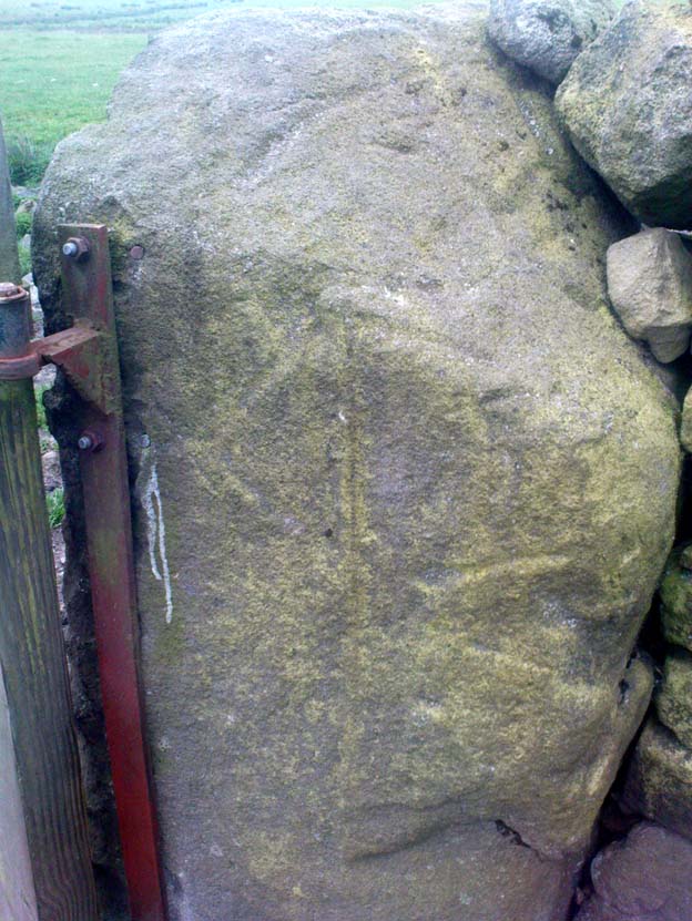
Worn metal scratches, made when dragged here?
This old worn gatepost however, perhaps has a history that only goes back a few centuries. It has been cleaved in half, as you’ll see if you visit it; but its western face is old and worn and it’s been embedded in the ground for a long time. On its northern face are the curious etchings of carvings, which are more akin to wounds from some past offence (perhaps when it was split in half), cleaved by metal toolings and dragged by farmers to be fixed in into present spot. It’s history may not be truly ancient. Twouldst be good to know for sure though…
References:
Wright, Joseph, The English Dialect Dictionary – volume 5, Henry Frowde: Oxford 1905.
* ‘Stinking’, stone-king or King Stone? Unlikely though…
There’s considerable Bronze- and Iron-Age archaeology all round here (cairns, settlements, earthworks and more), but it seems that the once-proud standing stone highlighted on the 1899 Ordnance Survey map found on the higher ground a half-mile north of Middlesknowes, no longer stands where it had been standing for all those thousands of years. What, pray, has become of it…?
References:
Royal Commission on the Ancient & Historical Monuments of Scotland, Roxburghshire – volume 2, HMSO: Edinburgh 1956.
Stone Circle (destroyed): OS Grid Reference – NT 666 286
Archaeology & History
One of those site place-names with a familiar ring to it: Har, boundary; law, tumulus (though it can also be used to mean ‘a meeting place’). Nevertheless, whatever the precise origin of the name, the site here seems to have been destroyed.
Although listed by the Royal Commission in 1956 as a stone circle, John Barnatt thinks it may have been a tomb of sorts – which is what the place-name infers if we’re puritanical about it. Alexander Jeffrey (1864) told us the most, saying that:
“A field to the east of Fairnington village is called Harlaw, from a circle of large stones which stood within it, but which have been removed to serve farm purposes.”
Its exact location is unknown, though the Royal Commission lads thought it probably “stood somewhere near the present Harelaw Plantation,” about a mile east of the village. Any more info on this lost site would be most welcome!
References:
Burl, Aubrey, The Stone Circles of Britain, Ireland and Brittany, Yale University Press 2000.
Gelling, Margaret, Place-Names in the Landscape, Phoenix: London 2000.
Jeffrey, Alexander, The History and Antiquities of Roxburghshire – volume 3, Seton & MacKenzie: Edinburgh 1864.
Royal Commission on the Ancient & Historical Monuments of Scotland, Roxburghshire – volume 2, HMSO: Edinburgh 1956.
Just get to the top of the hill thru the village and where the sharp bend turns, you’ll find one of the monoliths up against the wall above the roadside (hard to find in the undergrowth sometimes!). The other stone is on the eastern side of the road through Lidstone from the A44, halfway into the village itself.
Archaeology & History
Lidstone monolith
There are two small stones to be found in the lovely little hamlet of Lidstone. The main one—Leodwin’s Stone—is at coordinate SP 35517 24656; and the smaller stone further up the hill is at SP 35487 24627. First described in a treatise from 1235 AD as Lidenstan, the great place-name writer Ekwall (1940) thought this derived from ‘Leodwine’s Stone.” A few years later Gelling (1954) told us that “there is a monolith at Lidstone”, which she thought gave rise to the place-name, and not some chap named Leodwine. Whichever it may be, we certainly have two small upright stones here — both worth having a look at if such things take your interest. (Tom Wilson and I included them in our short survey of the standing stones of the region in 1999) Further up at the top of the hill from here are the remains of an old tumulus.
Folklore
Said by Caroline Pumphrey (1990) to be the resting place of old King Lud, one of England’s last great pagan kings; another local writer Elsie Corbett (1962) also told a tale well-known to folklore students about this little monolith. She related how a local man they knew as Mr Hitchcock told them,
“that they used to kid the boys there by telling them that when the stone hears the clock strike twelve it goes down to the stream to drink, and that it was just a ‘catch’ because there was no striking clock in the first place; but it is a ‘catch’ tacked onto some tale that must have been told in the hamlet long ages before there were clocks at all.”
The said stream is a short distance due north of here, down the little valley. The tale may come from it once acting as a shadow-marker, highlighting midday when the sun was high in the sky due south. Makes sense of the folktale anyway!
References:
Bennett, Paul & Wilson, Tom, The Old Stones of Rollright and District, Cockley: London 1999.
Corbett, Elsie, A History of Spelsbury, Cheney & Sons: Banbury 1962.
Ekwall, Eilert, Oxford Dictionary of Place-Names, OUP: Oxford 1940.
Gelling, Margaret, The Place-Names of Oxfordshire – volume 2, Cambridge University Press 1954.
Pumphrey, Caroline, Charlbury of our Childhood, Sessions Books: York 1990.