Clach na Sgoltadh, Bridge of Balgie, Perthshire

Legendary Rock:  OS Grid Reference – NN 61080 46501

Also Known as:

  1. Fionn’s Stone
  2. Praying Hands of Mary 

Getting Here

Clach na Sgoltadh, Glen Lyon (photo – Lisa Samson)

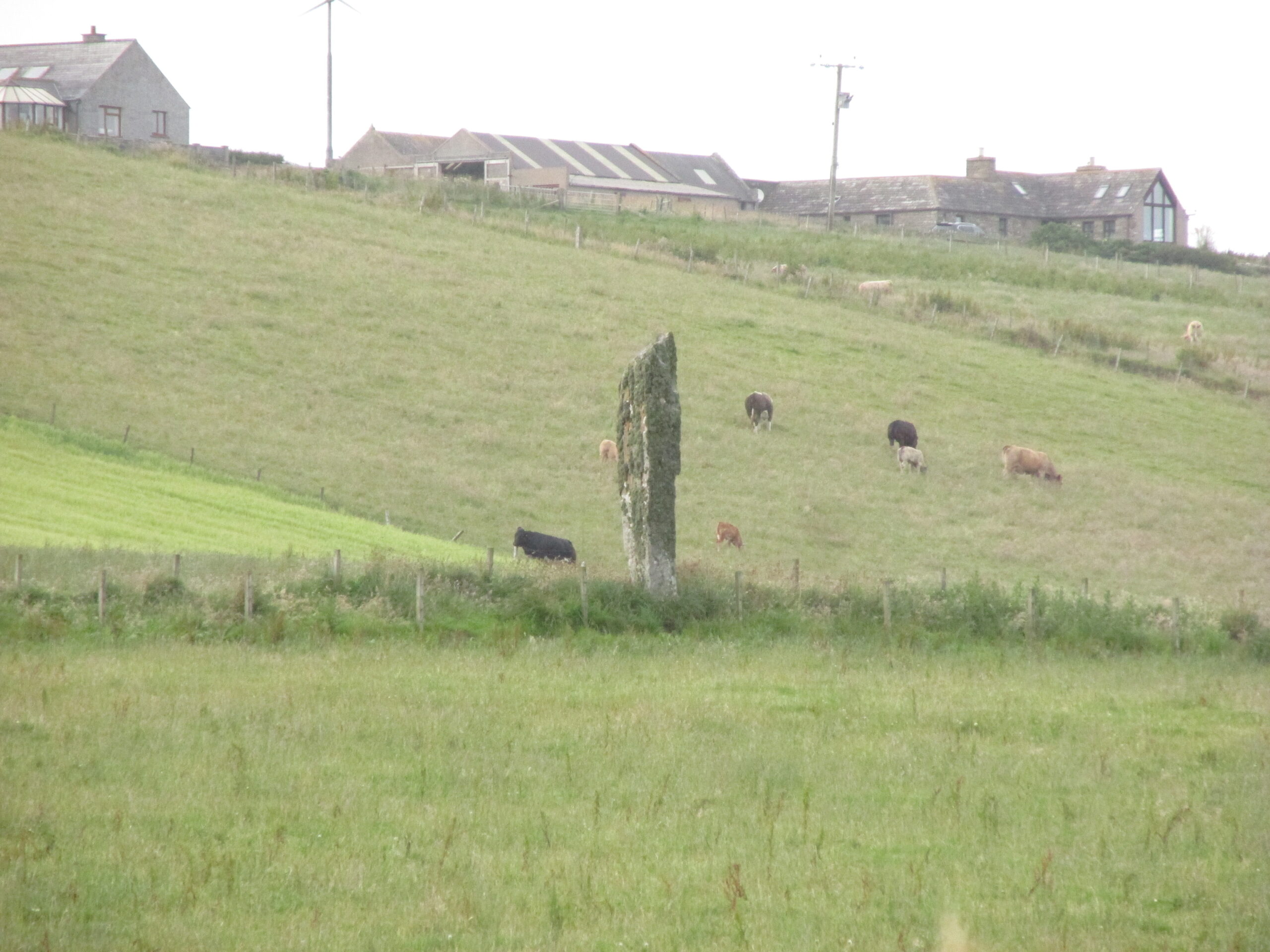
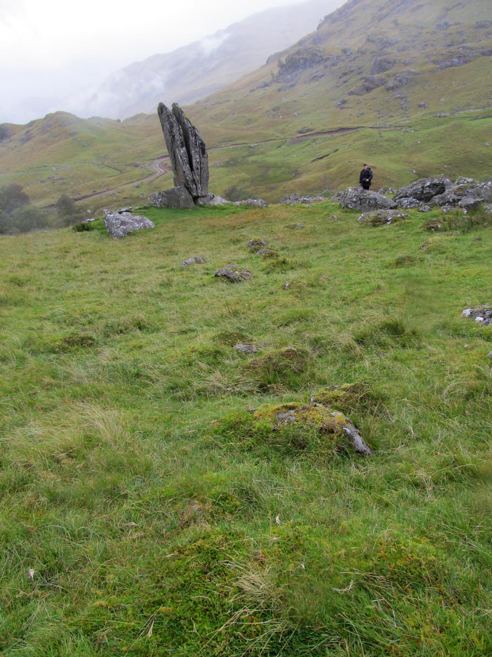
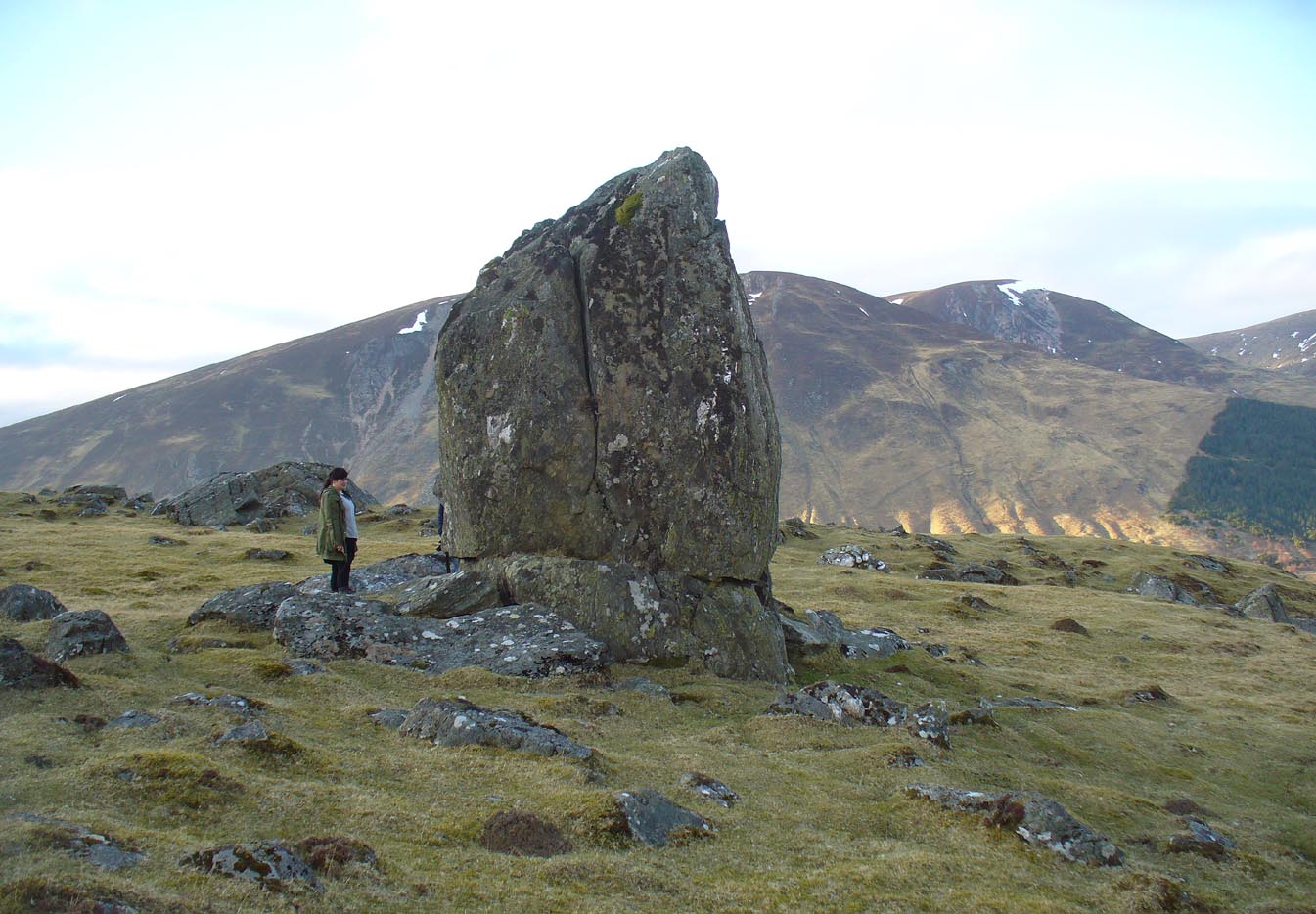
From Fortingall take the road into the legendary Glen Lyon.  About 8 miles along, a short distance past the Adamnan’s Cross standing stone, you reach the tiny hamlet of Camusvrachan.  On your left is a singular dirt-track, past some cottages.  Go along here and over the river bridge until you reach the junction on the other side.  From here, turn right and a half-mile on when you reach the farm and manor-house on your right, park up.  From here you’ll see a track going uphill.  Walk straight up and after a half-mile or so, keep your eyes peeled to your right.  You cannot fail to see this impressive giant on the slopes above you!

Archaeology & History

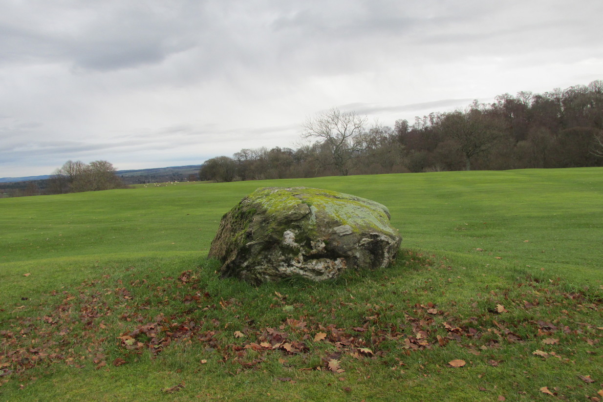
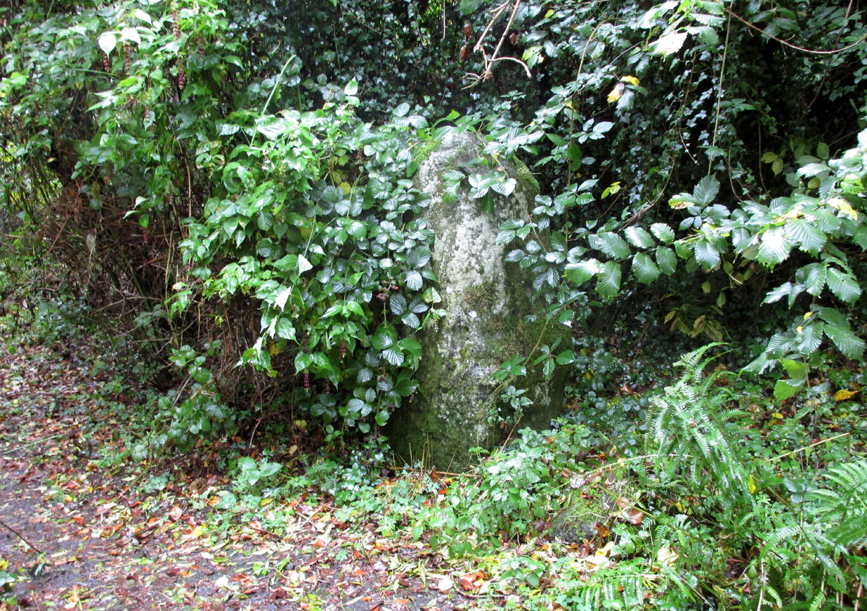
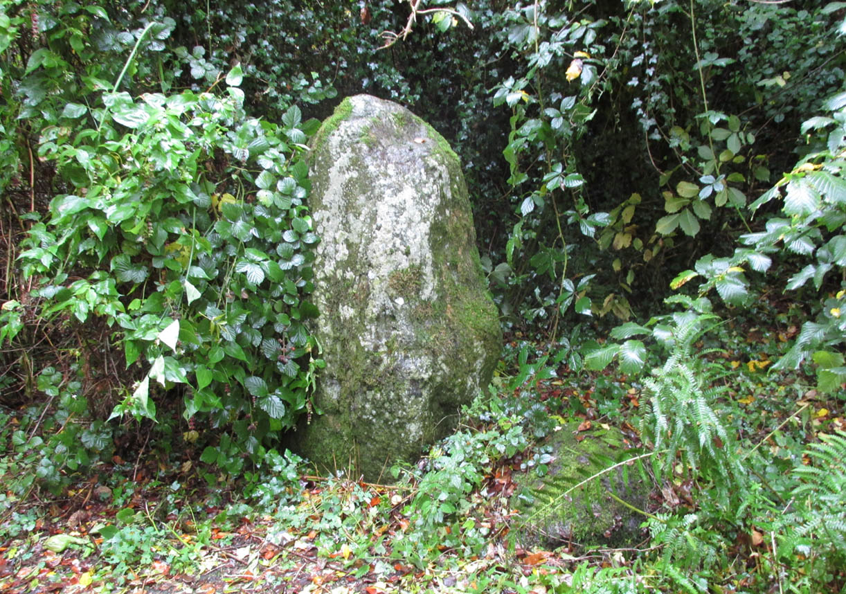
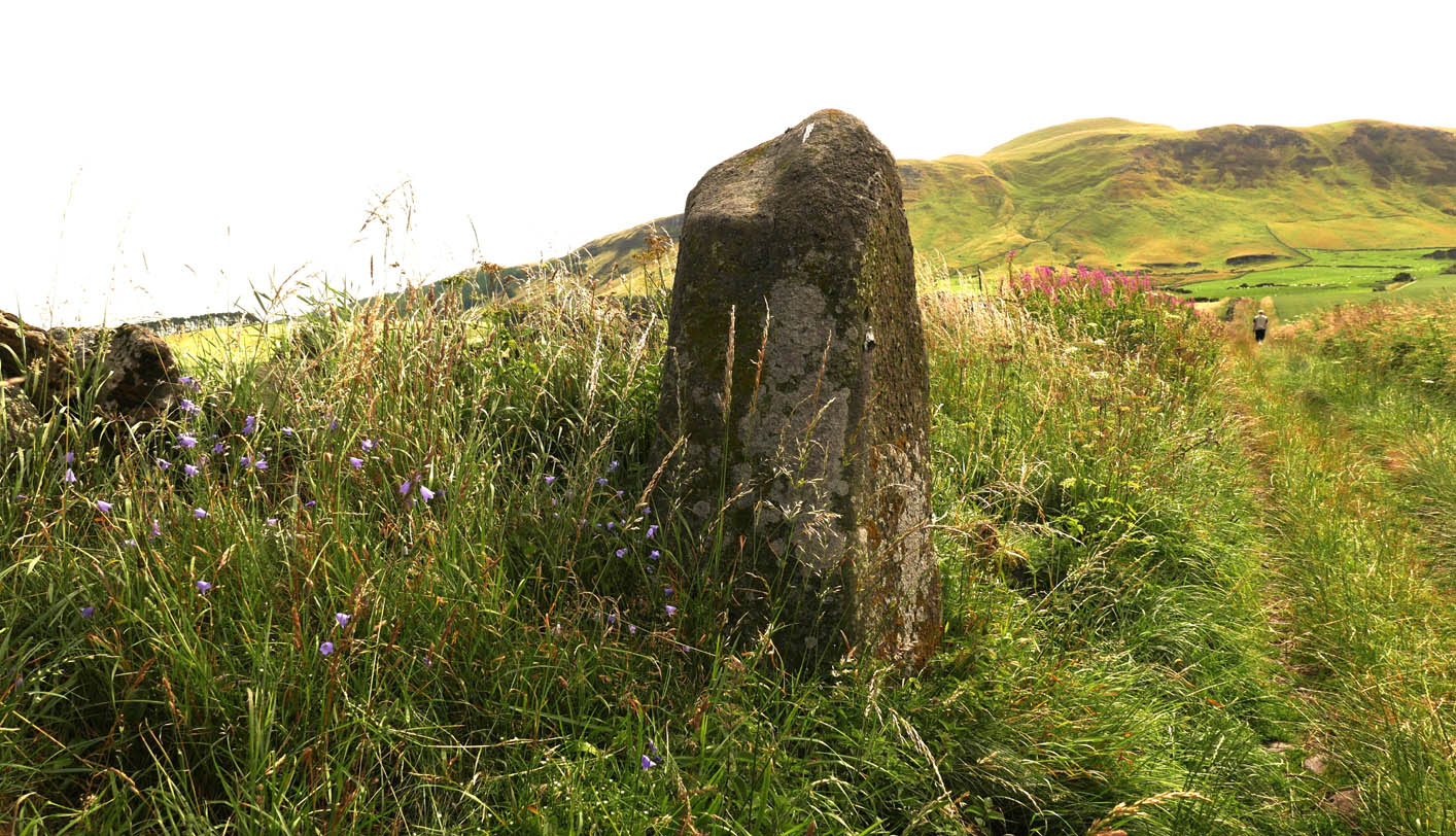
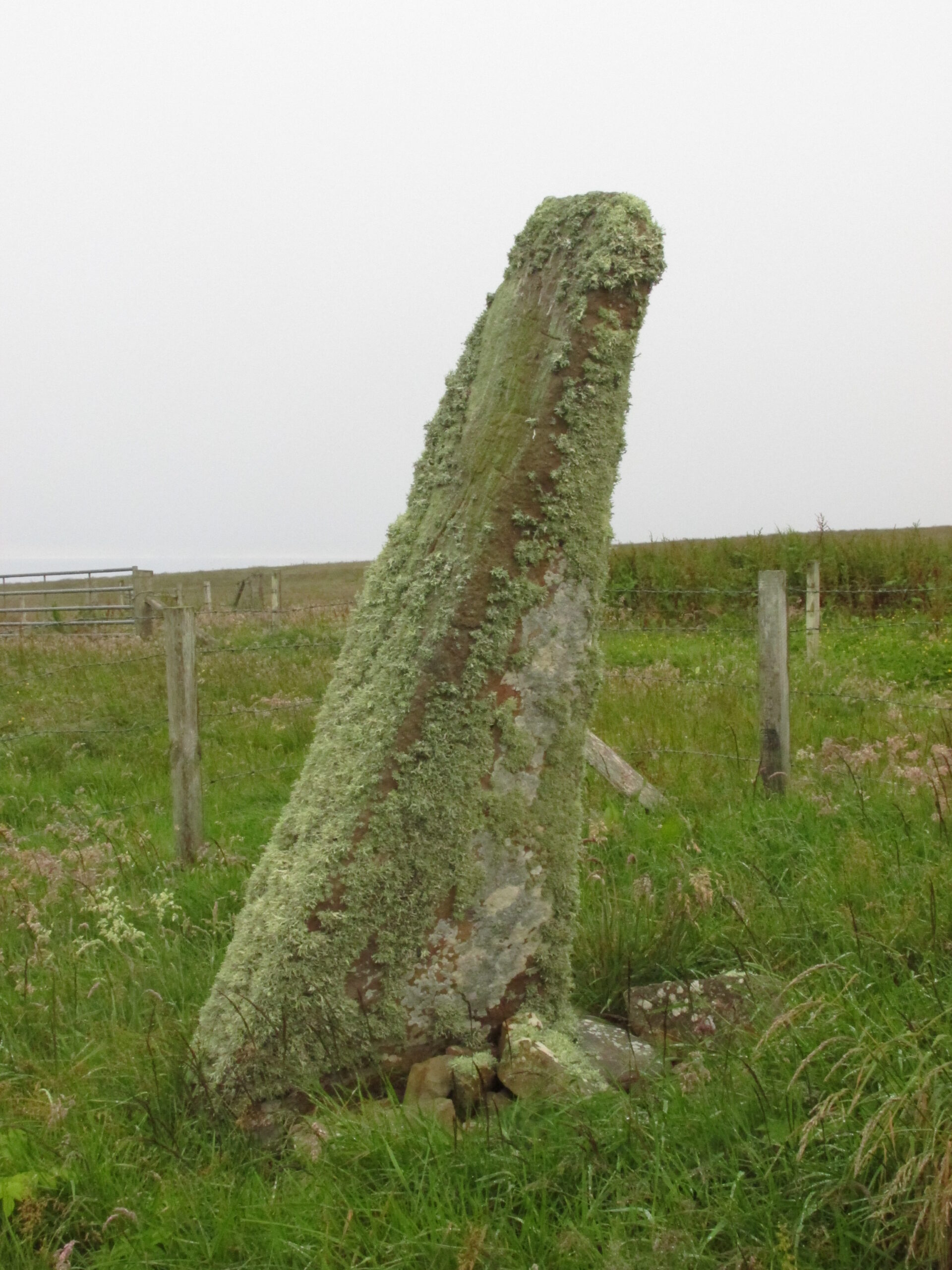
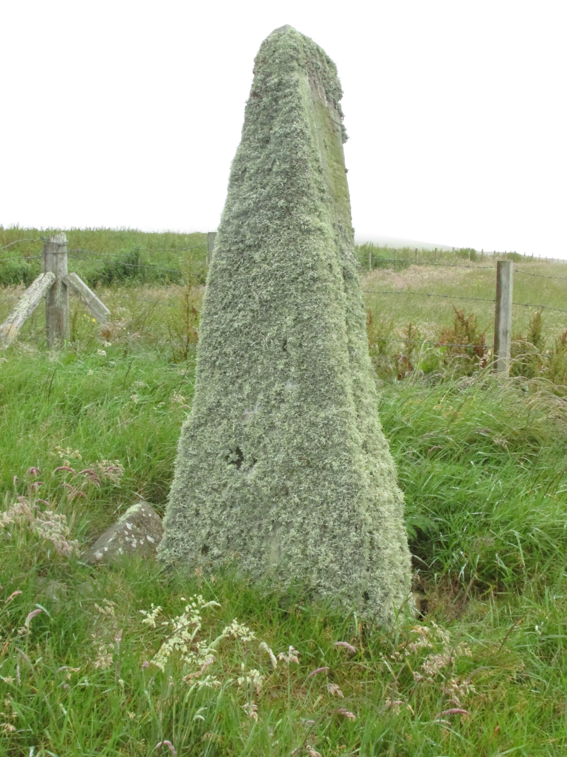
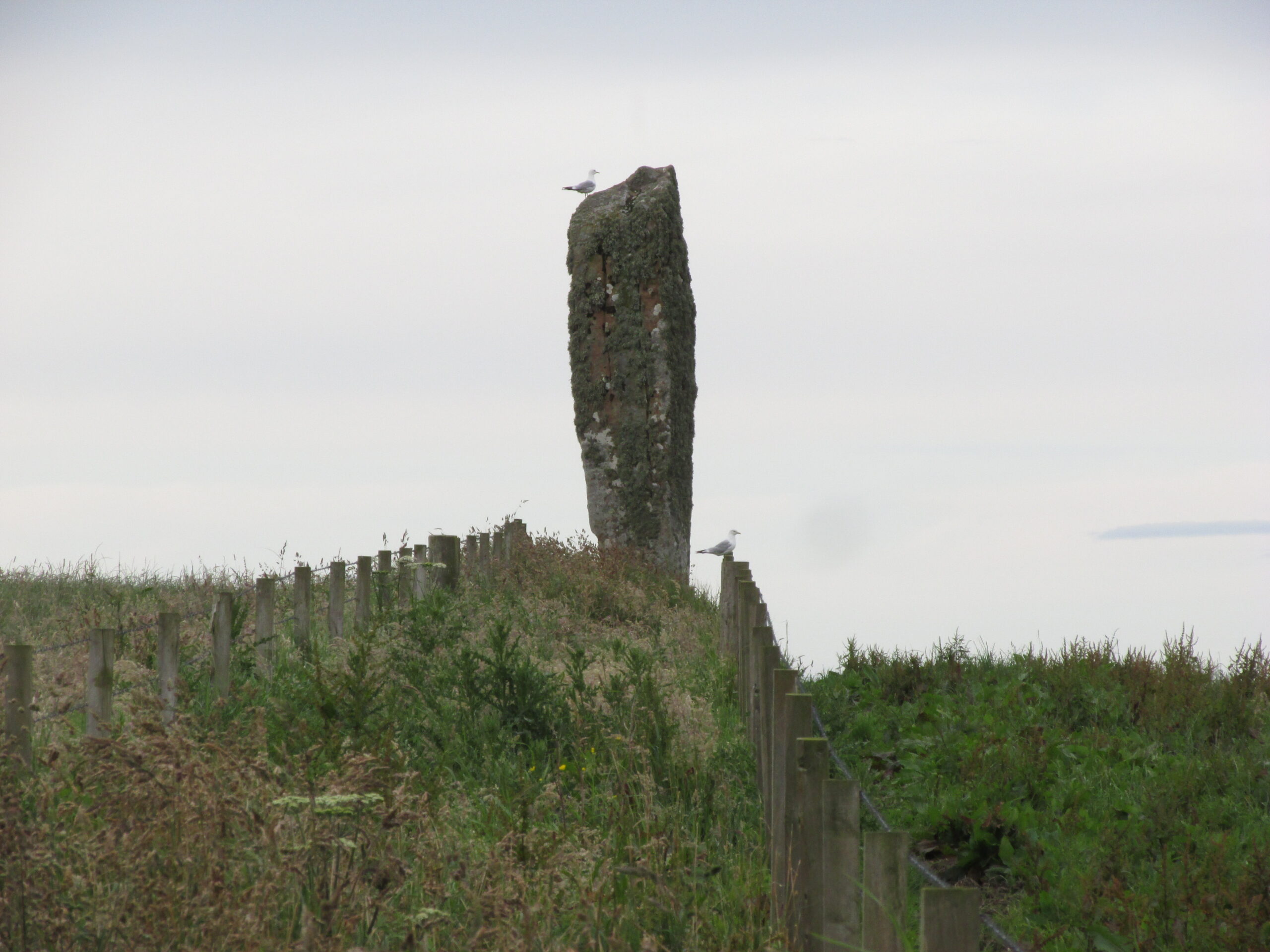
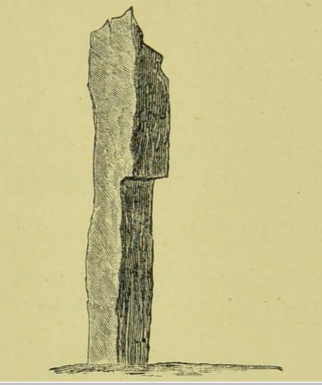
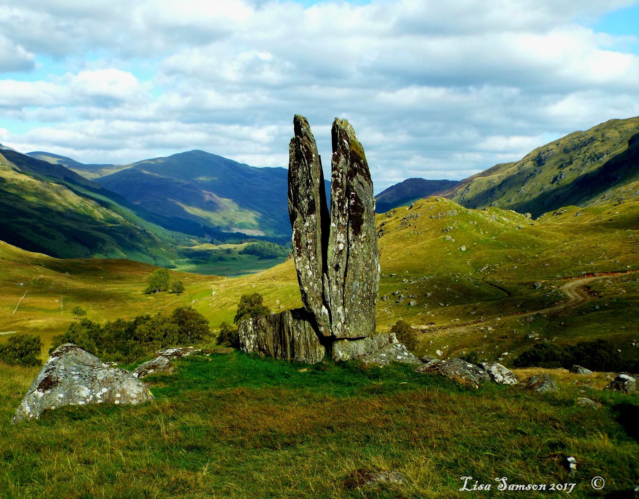
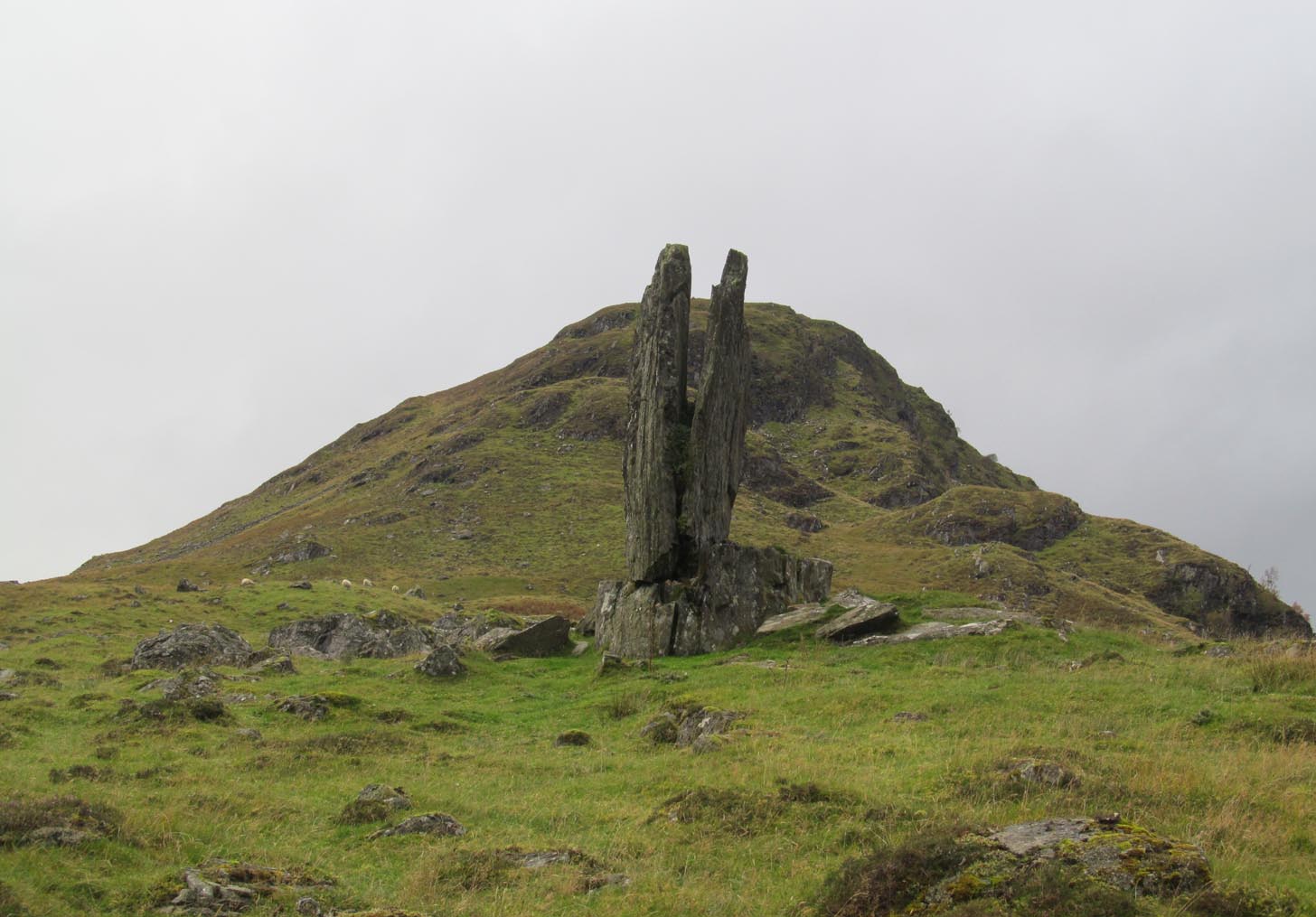
This is a truly mighty monolith! — a beauty no less!  Standing upon a rocky ridge nearly halfway along the glen, the landscape it looks across is, without doubt, some of the finest in the British Isles.  To our ancestors who, until just two hundred years ago peopled this and nearby glens in great numbers, this great stone would have been well known and had old myths told of it.  Today we have only bare fragments.

Clach na Sgoltadh (photo by James Elkington)

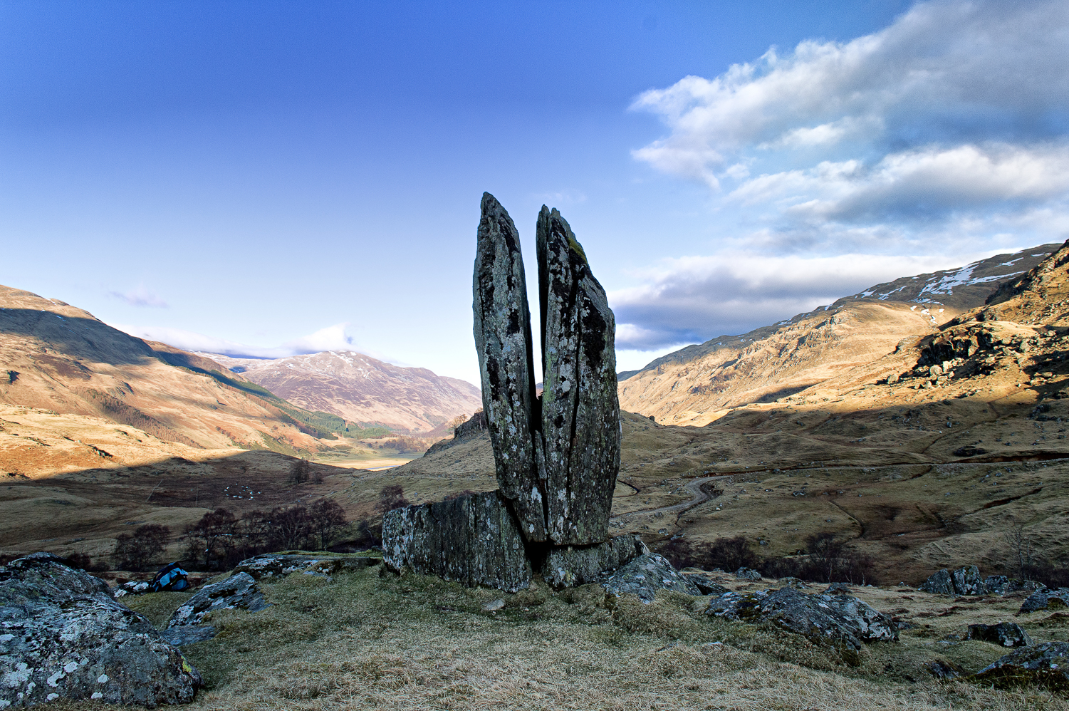
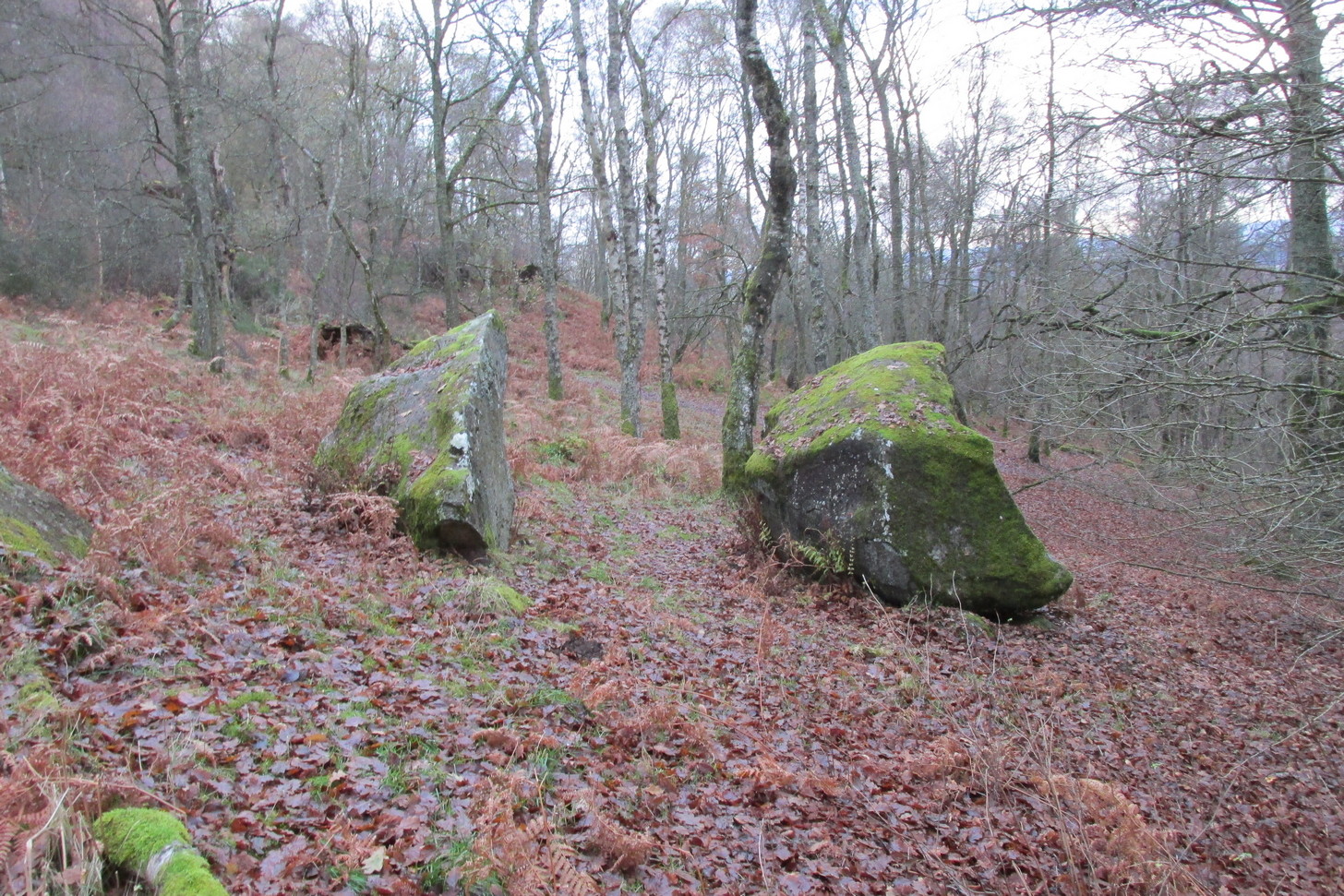
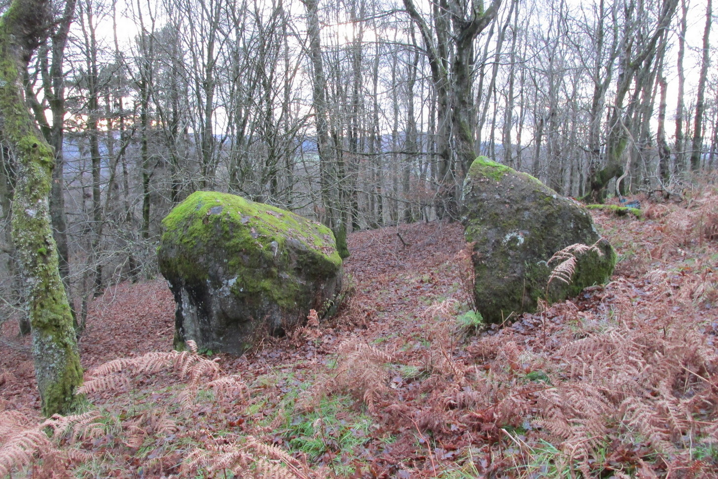
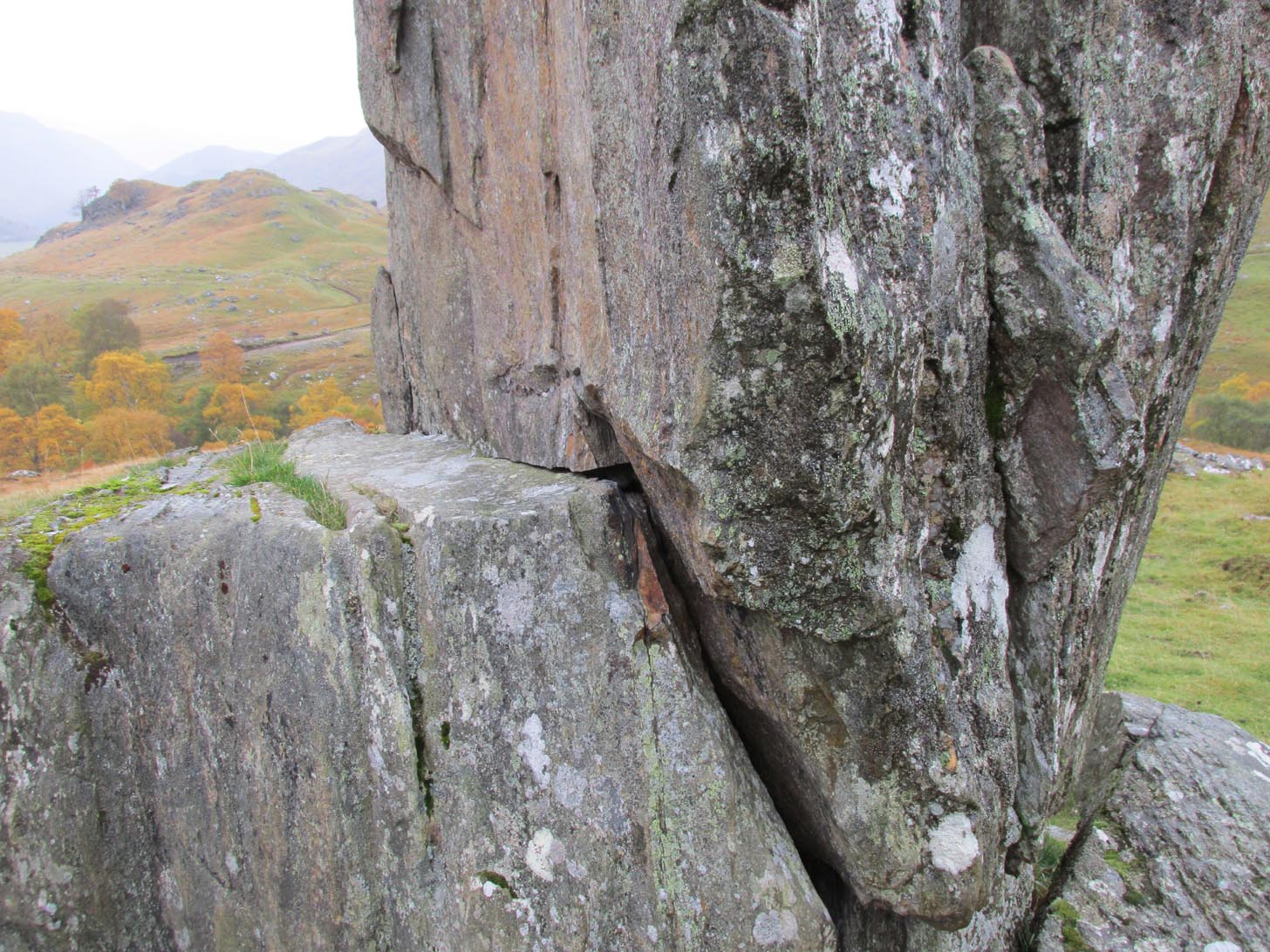
To give an ‘archaeological survey’ of any kind to this site would seem somewhat of an anathema, as it is generally deemed to be little other than one of Nature’s incredible creations.  We’ll come to that in a minute.  But what is quite certain is that a line of very old and very low-lying walling runs from up the slope and almost straight down to Clach na Sgoltadh.  You can see it pretty clearly in the photograph below.  The walling stops at the giant stone and continues no further downhill from the other side of the giant upright.

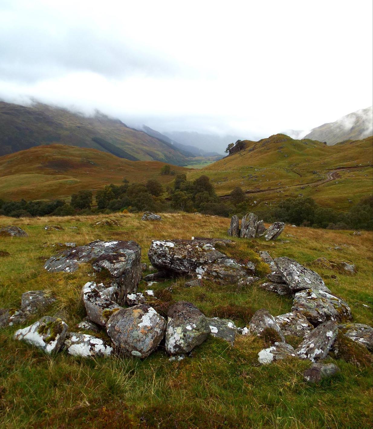
Walk diagonally down the slope about 30 yards south-east from the stone and you’ll find a small but distinctly man-made ring of stones, low to the ground, with an entrance on its northeastern side.  It’s somewhat of a puzzle as it’s too small for a hut circle (I laid down in it in various ways and found you’d have to lie foetal all night if you were to use it as  your own little abode), and it equally too small as an animal pen – unless it was for just one animal, which is most unlikely.  The small circular construction wouldn’t seem to be prehistoric, but it would be good to know what it is.

So, we do have some very slight archaeological association with the site, albeit minimal, with the very ancient walling that leads to the stone being the most intriguing.

Small stone ‘hut’
Low line of walling

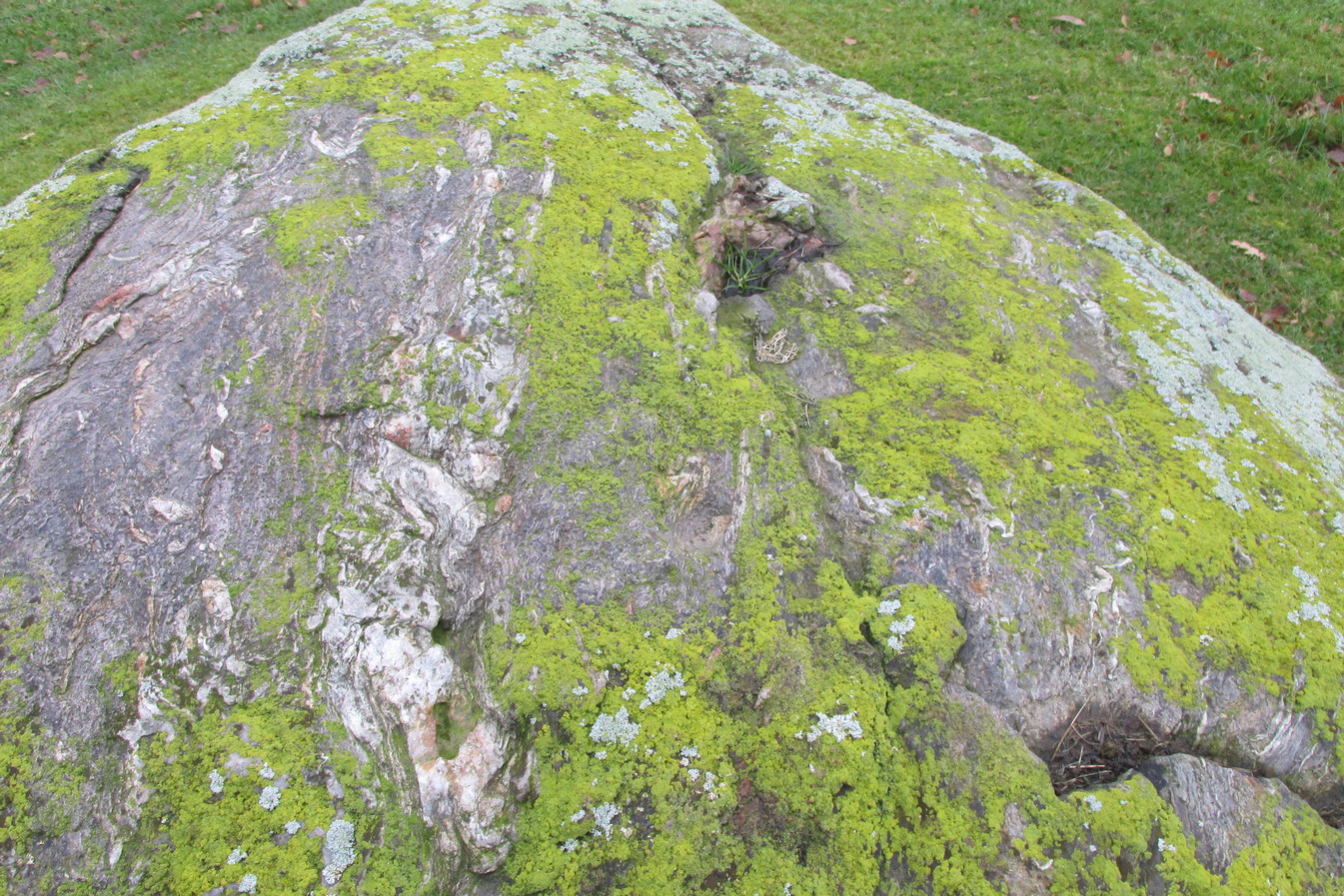
The stone is generally attributed to be a geological creation.  I certainly cannot say, as I have no expertise in the subject.  However, in the opinion of just about everyone with whom I’ve visited this stone, I seem to be the only one who doesn’t think it’s man-made.  A number of people have each insisted to me that it’s been stood upright by humans due to the quite distinct ‘squaring’ of the upright stone, particularly at the north-facing base.  —and been seemingly bemused at my own lack of conviction.  It does look as if it could have been cut and squared just as they all say but, let me repeat, I’m no expert at geology, and so all I can say is that I simply don’t know one way or the other. (useless prick that I am!)

“Perhaps a stone mason might know?” someone suggested—which seemed to be a good idea.  Certainly a stone mason would surely be able to tell if it had been cut and dressed at the base, where it fits into the large earthfast rock….

Cue Chris Swales: a reputable stone mason from near Skipton, North Yorkshire.  Chris and his friends took a week long whistle-stop tour in and around the Loch Tay region and thought they’d visit Glen Lyon.  I heard about this and so asked him if he’d have the time to visit this stone giant and, if possible, let us know his opinion: is is a natural obelisk, or does it look to have been erected by humans?  I told him my opinion and that of the geologists who give it an entirely natural provenance.

It was a few weeks later when he got back in touch and I asked him if he’d been up to Clach na Sgoltadh.

“I did,” he said. “it’s bloody impressive Paul.  And what a gorgeous landscape too.  I’d love to go there again.”

“Aye, it is Chris. And what did you think of the giant stone then?  In your opinion is it man-made or natural?”

“Well I don’t know for certain Paul,” he said, “but in my opinion I’m 95% sure that it’s man-made.”  He said it plain as day, just like a typical daan-to-Earth Yorkshireman.  Chris isn’t into any the energy ley-line stuff, so his words carry more weight than those who wanna spice-up a site by projecting their own beliefs onto a place.  As a result, I was somewhat taken aback by his words.

“What—are you sure Chris?!” I asked.

Cut & dressed stone?

“Like I said – I’m not 100% sure Paul.  I can’t really say it 100% – but I’m 95% certain that people cut and dressed the base of that stone and put it there.  If it’s natural, then I’d like to know how they think that’s the case.  I’m willing to be shown otherwise, but in my opinion, on the whole, it’s man-made.  People stuck that stone there!”

It would be great to get another stone mason’s opinion about this site; and it would definitely be good to read a geological viewpoint, but I’m not aware of any papers regarding this stone. (does anyone know of any?)  For my part:  I can only reiterate that I’m ‘unsure’ whether or not this is man-made.  I’m simply not qualified to give an objective opinion.

The curious thing is:  if this is Nature’s handiwork, then it would have been held in greater reverence to our ancestors than if it had been erected by people.  Impressive creations of Nature were always deemed to be inhabited by genius loci of truly archaic potency.  And in these deep impressive mountains, where the names of nature spirits still abound, this—without doubt!—would have been a place of considerable awe and sanctity.  May it remain as such…

Folklore

Looking to the west immediately uphill and behind Clach na Sgoltadh is the rising rounded hill of Creag nan Eildeag.  Legend has it that the great Celtic hero Fionn stood atop of this crag and fired one of his arrows at the stone, splitting it in half and leaving the stone as we see it today.

In a small cleft in the stone, quartz deposits can be seen along with an effigy of the Virgin Mary.  However, the title of the Praying Hands of Mary is a modern attribution and has no historical or mythic veracity.

References:

  1. Stewart, Alexander, A Highland Parish; or, The History of Fortingall, Alex MacLaren: Glasgow 1928.

Links:

  1. Clach na Sgoltadh on The Megalithic Portal

Acknowledgements:   Huge thanks to James Elkington and Lisa Samson for use of their photos.

© Paul BennettThe Northern Antiquarian


Ferntower carving, Crieff, Perthshire

Cup-Marked Stone:  OS Grid Reference – NN 87415 22626

Getting Here

From Crieff central, take the A85 road east out of town where the golf club is on your left.  Park up and ask the helpful lads who work in the shop, who’ll direct you to the standing stones on the golf course.  The cupmark is on the second stone along the row of stones from the direction you’ve approached from.

Archaeology & History

Here’s another one of those petroglyphs only of interest to those with the madness in their bloodstream!  Found within the ruins of the Ferntower megalithic ring is a distinct single cupmark on what John Coles (1911) called ‘Stone D’ in his survey:

The stone in question
Cupmark, lower centre

“Stone D, a boulder of whinstone also containing seams of quartz, 5 feet 6 inches in length and breadth, and 2 feet 3 inches above ground.  At some period the intention of blasting this block must have been considered, for there is the beginning of a jumper-hole near the centre of its upper surface.  Close to this unmistakably modern hole there is one single genuine cup-mark about 1¼ inch in diameter.”

A note of this was also made when Aubrey Burl (1988) surveyed the site, who pointed out that in accordance with a characteristic found at other ‘four poster’ stone circles, the carving is “another example of a decorated stone on the eastern side” (my italics) of such a ring.

Folklore

Although we have nothing specifically relating to the carving, it’s worth noting that when we visited the stone circle, the groundsman told us that it had been a place where local people gathered at summer solstice.

References:

  1. Burl, Aubrey, Four Posters, BAR: Oxford 1988.
  2. Coles, Fred, “Report on Stone Circles Surveyed in Perthshire, Principally Strathearn” in Proceedings of the Society of Antiquaries, Scotland, volume 45, 1911.

© Paul BennettThe Northern Antiquarian

Clach Mhallaichte, Cromarty, Ross & Cromarty

Legendary Rock:  OS Grid Reference – NH 7949 6746

Also Known as:

  1. Clach Mallach
  2. Clach na Mallachd
  3. Clackmalloch Rock
  4. Stone of Cursing

Archaeology & History

Stone shown on 1880 map

This large boulder found off the Cromarty coast, was highlighted on the 1880 OS-map of the region.  It is one of the ancient boundary stones of the township.

Folklore

We know from the vast array on the folklore of stones that many were imbued with magickal abilities, some of which were witnesses to vows and others to make curses from.  This large boulder off the coast of Cromarty was, according to Donald MacKenzie (1935), a place where the latter used to be done.  He told us:

“At Cromarty there is a big boulder known as the Clach na Mallachd (‘Stone of Cursing’).  Curses were delivered when an individual stood or knelt bare-kneed upon it.”

In an earlier account by the Ordnance Survey lads in one of their Name Books, they gave the following tale that had been narrated to them:

“A large stone Situate at the Low Water, and forming one of the boundary Stones of the burgh, the reason of its having this name is, that a young lad while Sitting on it was overwhelmed by the advancing tide and drowned, his mother when told of it, cursed the stone, hence the name Clach Mallach (Accursed Stone)”

References:

  1. MacKenzie, Donald A., Scottish Folk-lore and Folk Life, Blackie: Glasgow 1935.

© Paul BennettThe Northern Antiquarian


Cradle Stone, Crieff, Perthshire

Legendary Rock:  OS Grid Reference – NN 8654 2272

Also Known as:

  1. Canmore ID 25498

Getting Here

Cradle Stone on 1866 map

A bit troublesome to locate if you don’t know the area.  Get into the town centre where the paved St George Square is by the main road.  Cross the road and go up Hill Street, which runs straight into Ferntower Road.  A few hundred yards up turn left up Ewanfield, all the way to the very end at Crieff Hydro.  From here you’ll see the path uphill by the tennis courts.  Walk up and past the holiday chalets until your hit the road that curls round the bottom of the woods.  Go along until you find the car park and just above here by the roadside is a tourist board showing the Knock Walk footpath. The Cradle Stone is about 250 yards up the Knock Walk from here, 100 yards into the woods on the right.

Archaeology & History

This large broken boulder is the result of it once living further up the hillside.  One of Nature’s great forces then kicked the olde fella and he rolled down the hill to its present position.  It was mentioned in a detailed 19th century geological survey by Mr Thomson (1836), where he told:

“At Crieff, in Perthshire, there occurs a series of low hills running parallel to the Grampians.  These hills consist of old red sandstone and greywacke.  On one of them, the Cnock, the village of Crieff is built.  Upon the south-east side of this hill, towards the southern extremity, not far from the summit, there are deposited a number of boulder stones of syenitic granite. The largest of these is called the ‘Cradlestone’.  It is nearly spherical, quite smooth on the surface, and 29 feet in circumference.  It has been split in two by lightning, (according to the tradition of the place,) and one of the fragments has made one complete revolution down the hill and then stopped.  The weight of this boulder is about 30 tons.  The nearest mountains of syenitic granite, are those in the neighbourhood of Bennevis, distant more than 60 miles north-west…”

The stone was subsequently entered in Fred Cole’s (1911) outstanding survey of the local megaliths, although acknowledged it has having no archaeological pedigree.  The Cradle Stone, he wrote, is

“the appellation printed in Old English lettering on the Ordnance Map, given to one of two huge boulders difficult to find in the fir-woods at the western extremity of the Knock, and at a height of nearly 600 feet,  midway between Knockearn House and Culcrieff.   On visiting the site, the conclusion became apparent that these two blocks were merely natural curiosities, and had no interest for the archaeologist beyond the name.”

Folklore

In volume 10 of the New Statistical Account it was told how local folklore attested the Cradle Stone as being where the babies came from, perhaps intimating some fertility legend long since forgotten.

The main thing attached to this giant broken stone is the old folk-tale that used to be more well-known in the 19th century than it is today.  It was narrated at length in Macara’s (1881) fine pot pourri of local histories and legends and which I hope you can forgive me citing in its entirity here:

“In the memory of men still living, two well-known weavers, named James Livingstone and James M’Laren, lived in Barnkettick, at the west end of the town. Livingstone was a thorough wag, and M’Laren was somewhat of a simpleton. Livingstone was in the habit of telling his neighbour all sorts of extravagant stories about ghosts and witches.  The facility with which the latter fraternity could turn themselves into hares and scamper about was an accepted fact, which M’Laren as truly believed as his Bible.

“The Rocking or Cradle Stone on the brow of the Knock, behind the town, was supposed to be of Druidical origin, and for ages drew forth the fear and wonder of the natives. A belief prevailed that something valuable was buried in its foundation, and worth lifting, if it could only be got at.  Livingstone having heard of “Whang, the Miller” directed McLaren’s attention to the subject of valuable treasure being beneath the cradle stone, which was greedily swallowed, and he expressed his astonishment that no one tried digging for it.

“Livingstone suggested that they both should try it, and divide the spoil. M’Laren agreed, and it was resolved to make the attempt that night after dusk.  The necessary picks and spades were soon borrowed.  Livingstone called on an acquaint- ance or two, and informed them of the “ploy,” and they readily agreed to arrange and have some fun at the “howking” of the treasure.

“The acquaintances were up at the spot early, with a view to set some snares for hares, so that the journey would combine pleasure with profit.  They had also provided a few “squibs” for contingencies.  At the time appointed the two weavers, with their implements on their shoulders, arrived at the stone and set to work.  M’Laren did so with strong impressions of a coming calamity, which soon made him feel the greatest terror.  Livingstone worked with a will, and upbraided M’Laren with cowardice.

“With that a strange, unearthly sound came up the hill, and on looking round, a ball of fire was seen careering through the underwood.  M’Laren felt queerish and almost speechless. Another hissing sound was heard, and the strange fire came nearer.  Livingstone still wrought on, telling M’Laren never to heed, as these things were only bits of falling stars.  M’Laren thought otherwise. They were in the neighbourhood of Monzie, where it was certain there were plenty of witches, and it was evident something “no canny” was brewing.  He would have given anything to have been at his loom.

“In an instant three or four fiery darts from different directions came hissing along, and darted through the heath at their feet.  M’Laren was paralysed with fear.  Livingstone ceased work instantly, and jumping out of the trench he made, yelled he smelt brimstone, rushed from the stone and was lost in the darkness.  Poor M’Laren’s limbs trembled like a leaf and were scarcely able to support him.  As he was trying to follow his companion, another fire shower rained about him, and down the hill he went like a deer, yelling on Livingstone to wait on him.

“As he neared the parks above Milnab, the hares acid rabbits were scampering in all directions, and a few found their necks in the snares, which caused them to squeal at the pitch of their voices too.  M’Laren being now thoroughly convinced that the witches were let loose, speed was added to his limbs, and with supernatural fleetness he bounded over all obstructions and found himself in an instant or two in his room, and jumped into bed.  A cold sweat broke out all over his body and his heart beat with sharp thuds, shaking the bed.  It was some time ere he could collect his scattered senses, so as to realise whether or not he was dreaming. The moisture in his eyes caused every blink of the fire to appear like the horrid hissing fire darts of the Knock. After a time he fell into a stupor, the recent events being still vividly before his mind.

“His cronies on the Knock tumbled amongst the heather and broom, shouting with joy at the success of the scheme.  After giving vent to their excited feelings they went back to the Cradle Stone and lifted the picks and spades, and on their way home went round the snares and found a good “take.”  As they were killing the hares, Livingstone suggested that a live one be taken to M’Laren, which was readily agreed to.  On reaching home, Livingstone slipped into M’Laren’s house, and all seemed at rest.  Creeping quietly ben to Jamie’s end of the bigging, he tied the live hare to the foot of his bed.  As he was retiring he jostled against the hen roost and set the cock a-crowing, which so far roused Jamie that he thought it was scarcely morning yet.  The cock crowed away, and soon the neighbouring roosts bestirred themselves, and all the cocks in the neighbourhood returned the vocal sound, as if it were morning.

“Poor Jamie, on reflecting, resolved that if he got over the present raising of “Auld Clootie” scathless, he would pledge himself never to trouble him or his again.  As he thus pondered he thought he heard a strange pattering on the floor, and an occasional slight pull at the bed.  On straining his eyes and looking floorwards he saw something not unlike a reputed witch moving about the foot of the bed.  On closer observation this was fully confirmed, and he instinctively roared for help.  His daft brother was now roused, and he roared also, and the hamlet dogs lent a willing voice.  The wags who had collected outside rushed in, and on putting some fir roots on the fire the blaze showed Jamie, nearly demented, in bed, with his wearing clothes still on, and some dogs entering the room set a-worrying the hare.  At the sight of well-known faces Jamie jumped out of bed.  So much excited that it was feared that the joke had been carried rather far.  Livingstone was still equal to the occasion, and drawing a bottle of whisky from his pocket handed round a few glasses, and in a short time “they didna care for deils a boddle.”  Jamie was advised to divest himself of his clothes and go to bed, which he did, and soon fell into a deep sleep, and awakened next morning not much the worse.  The affair got wind, and many a country fireside was made merry by the story of the Cradle Stone treasure.”

References:

  1. Coles, Fred, “Report on Stone Circles Surveyed in Perthshire, Principally Strathearn” in Proceedings of the Society of Antiquaries, Scotland, volume 45, 1911.
  2. Macara, Duncan, Crieff: Its Tradtions and Characters, D. Macara: Edinburgh 1881.
  3. Thomson, Thomas, Outlines of Mineralogy, Geology and Mineral Analysis – volume 2, Baldwin & Cradock: Edinburgh 1836.

Acknowledgements:  Big thanks for use of the 1st edition OS-map in this site profile, Reproduced with the kind permission of the National Library of Scotland

© Paul BennettThe Northern Antiquarian

Fairies’ Cradle, Cromarty, Ross & Cromarty

Legendary Rock (destroyed):  OS Grid Reference – NH 792 651

Archaeology & History

In the ruins St Bennet’s Chapel, along with his accompanying holy well (NH 7923 6502), could once be seen a curiously shaped rock which, according to tradition has been destroyed.  In Mr Innes’ (1855) major history work he mentioned this Fairies Cradle in passing.  Not far from here and close to the coast, is a curiously-shaped boulder with several natural cupmarks (at NH 9150 6497).

Folklore

In Hugh Miller’s (1878) definitive local history work, Scenes and Legends, we have our main description of this once important site.  It existed,

“near the chapel itself, which was perched like an eyry on a steep solitary ridge that overlooks the Moray Firth, there was a stone trough, famous, about eighty years before, for virtues derived also from the saint, like those of the well. For if a child was carried away by the fairies, and some mischievous unthriving imp left in its place, the parents had only to lay the changeling in this trough, and, by some invisible process, their child would be immediately restored to them. It was termed the fairies’ cradle; and was destroyed shortly before the rebellion of 1745, by Mr. Gordon, the minister of the parish, and two of his elders.”

The story of children here being carried away by littlepeople and then restored by an impish offering, is a play on the site being a healing stone.  There are numerous other “curing stones” found elsewhere in Scotland, but with their own respective traditions—like the Measles Stone at Fearnan, the Whooping Cough Stone near Killin, and many others.

If anyone knows anything more about this lost “curing stone”, please let us know.

References:

  1. Alston, David, “The Old Parish Church of Cromarty,” Cromarty, May 2005.
  2. Innies, Cosmo, Origines Parochiales – volume 2:2, W.H. Lizars: Edinburgh 1855.
  3. Miller, Hugh, Scenes and Legends of the North of Scotland; the Traditional History of Cromarty, William Nimmo: Edinburgh 1878.

© Paul BennettThe Northern Antiquarian

River Avon Stone, Bulford, Wiltshire

Standing Stone (lost):  OS Grid Reference – SU 161 432

Archaeology & History

In William Stukeley’s Stonehenge, he described a number of monoliths outlying Salisbury Plain that also possessed a prehistoric pedigree.  Most of them have been recorded, but this one seems to have been forgotten about — perhaps by virtue of it having fallen into the River Avon!  Edgar Barclay (1895) described it in his fine survey, saying:

“In the bend of the river below the village, is a large submerged stone; only during drought is any portion of it visible above water; it can, however, in ordinary times, be dimly seen from the bank, which is of chalk, here very steep and overgrown.  The country people assert that a metal ring, “turning always,” is let into its upper end.  Legend relates that when the Devil brought the rocks of Stonehenge from Ireland, tied together with withes, this stone escaped from the bundle and fell into the river.  Its position forbids the belief that it got fixed in the bed of the stream when its passage to Stonehenge was being attempted, for it lies immediately beneath the crest of a very steep bank, and at its most inaccessible point; as the stream sweeps against this, the water must always have been deep at this spot, the open valley would everywhere offer more favourable points for such an operation, especially would this be the case before the Avon was dyked.  A boundary stone would have been placed on the brow of the hill; if the stone be a grey-wether, as report says, and as is probable, it may originally have stood on the bank, and “once upon a time”, a ring having been fixed in it, it may have been dragged into the stream to moor a ferry-boat.  It lies closely midway between the stone on Bulford Down and that in Durrington fields.”

One wonders if any local people might know more about this…

References:

  1. Barclay, Edgar, Stonehenge and its Earth-works, D. Nutt: London 1895.

© Paul BennettThe Northern Antiquarian

Abernethy Den, Abernethy, Perthshire

Standing Stone:  OS Grid Reference – NO 1883 1610

Also Known as:

  1. Canmore ID 185835

Getting Here

Hidden by creeping ivy

Along the main A913 Perth Road that runs round the northern edge of Abernethy village, as you approach the village from the western side, go right at the mini-roundabout up the Main Street into the village.  However, just where this roundabout is, there’s a footpath into the trees known as the Castlelaw.  Walk up here, keeping to the left-side of the burn (don’t cross over onto the right-hand side!) and after about 200 yards or so, keep your eyes peeled for a large upright stone, almost overgrown in dark vegetation on your left.

Archaeology & History

An intriguing standing stone in a most unusual position: a small wooded glen with a steep slope on its immediate eastern side, very enclosed.  It’s quite a big thing too, standing some six-feet high with the usual worn rounded crown, typical of olde stones.

The olde stone, unmasked

In the very brief account of this site by Hallyburton & Brown (2000) they describe this “previously unrecorded /lost standing stone and possible ruinous stone circle.”  This is also echoed in Canmore’s description.  A standing stone we certainly have, but in several visits here there was no evidence of any stone circle either side of the burn.  It was suggested that the “circle” may once have been atop of the slope immediately above this stone, but again there is no evidence at all to suggest this and old maps show nothing.  I’m extremely doubtful of any megalithic ring here (I’d love to be wrong though).

References:

  1. Hallyburton, I. & Brown, R., “Abernethy Den (Abernethy Parish),” in Discovery & Excavation Scotland, New Series – volume 1, 2000.

© Paul BennettThe Northern Antiquarian

Wester Nether Urquhart Stane, Gateside, Fife

Standing Stone:  OS Grid Reference – NO 1862 0799

Getting Here

Wester Nether Urquhart Stane

To find this stone take the A91 to Gateside and turn into Station Road.  Follow to the end, then turn right.  200 yards on there is a parking spot for the Bunnet Stane, and a track to follow.  As you go up this track towards the Bunnet, approximately 280 yards on is this beauty.

Archaeology & History

At over 6ft high, this previously unrecorded standing stone has quite a presence on this slight incline.  It’s hard to tell the true height as he is set in a grassy bank with a drystane wall behind.  It has obviously been used as a gatepost at some time in the past, but there’s no hint of being moved for that purpose.  There are many ancient relics in this area and there used to be a stone circle across the road and behind Nether Urquhart Farm, along with several burial cairns.  I reckon there is a lot more to be found, and we fully intend to go back there.

© Maggie Overett, The Northern Antiquarian

Stews, South Ronaldsay, Orkney

Standing Stone: OS Reference – ND 46558 88998

Also Known as:

  1. Canmore ID 9516
  2. Stowse

Getting Here

A wind blown stone

Take the third left road off the A961 past St Mary’s Hope, travelling south, taking the right fork at Lythes, and continue down to the end of the metalled road. From there, walk up the slope to your right (south) and follow the fence on your left into the next field and the stone will be seen in a fenced enclosure.

Archaeology & History

Two things strike you when you first see this stone, the triangular shape of the east facing side, and the lichen which covers this face and much of the rest of the stone giving it the distinct illusion of having a green velvet coat! From another angle it has a distinct lean and there are quite a few packing stones around its base. The Royal Commission inventory (1946) describes it thus:

Stone on 1881 map

“On a ridge barely a quarter of a mile S of the farmhouse of Stews is a triangular block of red sandstone nearly 6 ft high, set with a packing of small stones at the base and with its axis N-S.  At the bottom where it is widest it measures 2 ft. 6 in. across and is from 12-13 in. thick.  As it rises it tapers gradually to a pointed top, which is slightly inclined towards the W.”

George Low on his 1774 tour wrote:

“Left this spot, and May 12th, proceeded southward by Stowse head; observed on the hill the remains of a tri-angular monument, but very much defaced, and two of the stones broke to the stumps. Tradition is there none as to the reason &c. of its erection.  The figure with a plan follows…”

George Low’s 1774 sketch
A coat of lichen

There is now no trace on the surface of the other two stones of this group so we are fortunate to have Mr Low on the spot sketch to record them. The stones would have been visible to the seafarers of times past who may have used them as navigation landmarks in pre-literate times, this being one of a number of surviving coastal stones on the Orkneys but whether they were erected for this purpose cannot be known.  If you’ve been to see the Sorquoy stone up the coast, the surviving Stews stone is worth the journey if only for its ‘velvet’ coat.

References:

  1. RCAHMS, Twelfth report with an inventory of the ancient monuments of Orkney and Shetland, 3v. Edinburgh. 1946
  2. Low, George, A Tour Through the Islands of Orkney and Schetland…collected in 1774, William Peace & Son: Kirkwall 1879.

Acknowledgements:  Big thanks for use of the 1st edition OS-map for this site profile, Reproduced with the kind permission of the National Library of Scotland

© Paul Hornby 2020, The Northern Antiquarian


Sorquoy, Kirkhouse Road, South Ronaldsay, Orkney

Standing Stone: OS Reference – ND 46905 91403

Also Known as:

  1. Canmore no.9605 
  2. Eastside
  3. Papley
Stone on 1881 map

Getting Here

Travelling south on the A961, take the first road left past St Margaret’s Hope, and follow it over the cross roads, and down the hill towards the sea, and it’s visible on the left hand side. You can’t miss it! It’s accessed by a narrow pathway which has been partly ditched – be careful!

Archaeology & History

View from the SE
View from the track – SW

One of the less well known but most impressive of the Orkney standing stones, and seemingly one of the least visited.  On my visit in July 2019, it was clear no one had walked the path for several months.  The Royal Commission Inventory describes it as being, “14′ – 14′ 6″ high with some packing at the base. At 3′ above ground level, it is 2′ 6″ wide and 18″ thick, thickening to 21-22″ as it rises.”

It has a distinctly top-heavy look, and although invisible from the west above the brow of the hill, it can be clearly seen from the sea.

George Low visited the stone on May 11th 1774, saying:

‘In this beautiful hollow, in a cornfield, saw a large erected stone about 16 feet above ground, probably monumental, tho’ tradition is silent about it, and by digging nothing was found that could certainly prove this’.

Described by local historian George Barry (1748 – 1805):

George Low’s 1774 drawing

‘To the north (of South Ronaldsay), – at no great distance, is a most beautiful vale, with the ocean on one side, and gently declining hills on the other; which, for the production of every sort of beneficial crop, is far superior to any other part of the island. In the middle of this pleasant spot, on the brow of a hill, is a monumental stone, sixteen feet high, which, like many others through the country, bears no marks of human art, in carving, figures, or inscription. The whole delightful dale is known by the name of Paplay’ .

If you’re in the islands, this impressive stone is certainly worth a detour!

References:

  1. Barry, Dr George, History of the Orkney Islands, Longman,Hurst,Bell & Orme: London 1808.
  2. Low, George, A Tour Through the Islands of Orkney and Schetland…collected in 1774, William Peace & Son: Kirkwall 1874.
  3. Royal Commission Ancient & Historical Monuments, Scotland, Inventory of the Ancient Monuments of Orkney and Shetland, HMSO 1946.

Links

  1. Sorquoy on The Megalithic Portal

Acknowledgements:  Big thanks for use of the 1st edition OS-map for this site profile, Reproduced with the kind permission of the National Library of Scotland

© Paul Hornby 2020 The Northern Antiquarian