Stone Circle (destroyed): OS Grid Reference – SE 088 256
Archaeology & History
The place-name authority A.H. Smith (1961), in searching for the meaning behind the old region in Halifax known as “stannary”, just west of the town centre, was puzzled by its implications and found it wanting, so he took the most likely option as he saw it, writing, “probably it is a stone circle,” from the archaic verbs stan (stone) and hring (ring).
First recorded in the Halifax Court Rolls of 1575 as “Stannerying”, this implied it to be a place where tin-ware was sold in a field, “though that word belongs rather to Cornwall,” he said, and it appeared out of place at the time it was written. So he looked elsewhere. The Halifax Parish Registers of 1578 didn’t help much, describing the place as “Stanerye.” However, the Halifax Rent Records of 1588 named it as “Standeringe”, which is much closer to Smith’s idea. With each written instance we certainly find the old English stan, but the suffix in two instances is difficult to assess with firm conviction.
If we could locate additional folklore or other historical data that might throw further light on this, it would be an important find. The finding of prehistoric burial remains less than a mile south of Stannary on the other side of town shows that ancient man was in Halifax, but it would be good if we could find more…
References:
Smith, A.H., The Place-Names of the West Riding of Yorkshire, Cambridge University Press 1961-63.
Stone Circle (destroyed): OS Grid Reference – SU 161 684
Also Known as:
Clatford Stone Circle
Archaeology & History
John Aubrey’s early drawing (soz about the crap quality)
Also known as the Clatford Circle, it was described by both of the old pioneers, John Aubrey and William Stukeley: Aubrey saying the monument could be found “in a lane leading from Kennet to Marlborough… (consisting) of eight huge large stones, roughly hewn… in a circle, which never could be by chance.” Will Stukeley reckoned that four other stones close by, “may possibly have been the beginning of an avenue.” We might never know for sure.
The local Avebury authority, Pete Glastonbury, showed us a spot which he thinks may have been the where the circle stood, and where a couple of decent-looking stones lay by the side of the track that could have once been a part of this circle. It looked as good a contender as anything else. Has all trace of this monument truly been destroyed?
References:
Burl, Aubrey, Prehistoric Avebury, Yale University Press 2002.
The isle of Boreray is four miles northeast of Hirta and here once lived, according to legend, a christian hermit. However in the reverend Kenneth Macaulay History of St. Kilda (1764), he told us that the character was actually a druid. Take your pick! The druid lived at Stallir House, adjacent to which, said Macaulay, was
“a large circle of huge stones fixed perpendicularly in the ground, at equal distances from one and other, with one more remarkable regular in the centre which is flat in the top and one would think sacred in a more eminent degree.”
In a later article by F.L.W. Thomas (1867) he also mentioned this ‘stone circle’, though indicated its decline. Additional information on this little known stone is sparse due to its somewhat remote position on one of the uninhabited isles of St. Kilda. I wouldn’t mind spending a month or two there, roughing it, to see what’s what!
References:
Macaulay, Kenneth, The History of St. Kilda. Containing a Description of This Remarkable Island; the Manners and Customs of the Inhabitants; the Religious and Pagan Antiquities There Found, T. Becket: London 1764.
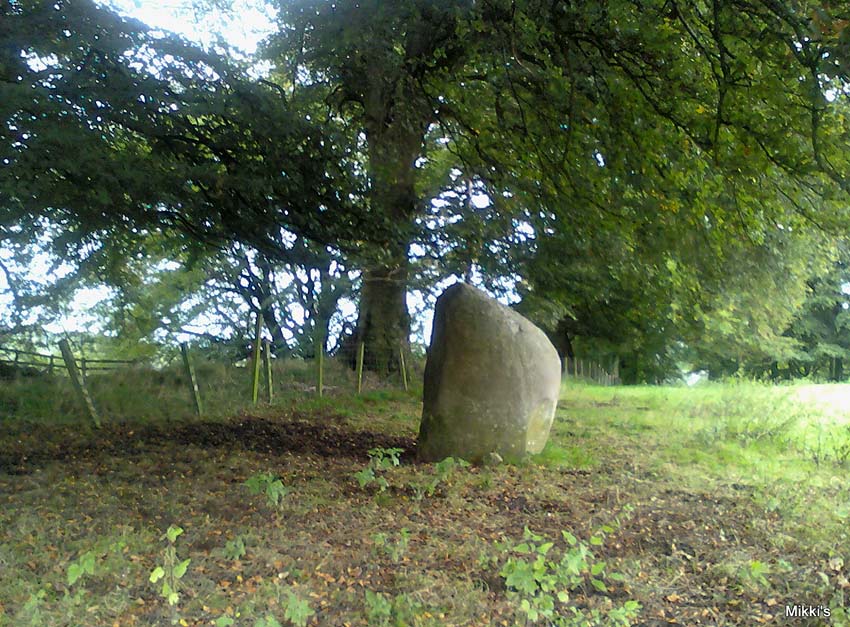
From junction 16 on the A74(M) turn off an go up the B7076 road, roughly parallel with the motorway, for about 2 miles, turning right – over the A74(M) – until you hit the T-junction by the lovely hamlet of Newton. At the T-junction turn right again and along down the road for just 300 yards or so. You’ll see the small Skip Cottage, almost overgrown by the tiny roadside on your right. Stop here and look into the field across the road. It’s right in front of you!
Archaeology & History
Looking SW
Despite the size and almost romantic setting of this large standing stone, I can find little by way of early descriptions or archaeological reports here. Nearly six feet tall with its long axis aligned east-west and in seeming isolation, I find it hard to believe that we have no other sites or relevant data here. Echoing the work by Alexander Thom (1990:2), Aubrey Burl (1993) makes mention of it as one in a possible “pair” of standing stones, with its companion being “18ft (5.5m) away…in roadside bank,” but this is debatable. This second stone seems as much a part of the old walling. On purely subjective grounds, it gave the impression of once playing a part in a stone circle — an opinion also held by the Scottish Royal Commission (1920) lads after their visit here in August, 1912. Does anyone know anything more about this place?
References:
Burl, Aubrey, From Carnac to Callanish, Yale University Press 1993.
Royal Commission on Ancient & Historical Monuments, Scotland, Inventory of Monuments and Constructions in the County of Dumfries, HMSO: Edinburgh 1920.
Thom, A., Thom, A.S. & Burl, Aubrey, Stone Rows and Standing Stones – volume 2, BAR 560: Oxford 1990.
Go through Killin past the Bridge of Lochay pub, turning immediately down the small lane by its side. After about 3 miles you’ll cross over the small river past Duncroisk. Keep going for another few hundred yards (if you reach Tullich you’ve gone too far), watching out for the gate on your left. Walk up to the top of this field, over the wall and up again. You’ll see a couple of tall trees with distinctive walling next to them, just on a ridge above you. That’s where you’re heading!
Archaeology & History
This is a fine-looking example of a prehistoric enclosure, perched on the edge of one of the grassy knolls on the far western extremities of the deserted village of Tirai. If you walk towards it from the derelict village east of here, the elliptical form of the site gives you the distinct impression that you’ve just chanced upon a seemingly unknown stone circle nestled upon the edges of this gorgeous Scottish glen; but this initial excitement is soon dispelled once you get into the heart of the site!
Southern line of wallingLooking east
Although you’ll find a couple of derelict post-medieval buildings on the western side of this structure, the lay-out of this monument would seem to be Iron Age origin, perhaps earlier. It certainly has all the hallmarks of a walled structure from that period and typifies many others that I’ve explored down the years.
The eastern and southern sections of the walls are in very good states of preservation, although the ground has obviously grown up and around the bases of the stonework. It has a total outer circumferences of about 95 yards (87m), with the many upright stones measuring between 12 inches to more than 3 feet in height. The western section of the enclosure is mostly overgrown but easily traced on foot. Near the centre of the site is a large flattish stone that gave the impression of having an oratory function from where one could speak to the rest of the people sat around the inner edges of the enclosure — but this was a purely subjective impression.
NE sections of enclosureOuter section & ‘standing stone’
On the southern side of the elliptical structure is another, outer line of walling, or a stone alignment of some sort just a few yards long, consisting of just a few upright stones — one of which stands considerably taller than all the others hereby, giving the impression of a standing stone. It has a large natural cup-marking on its southern face.
To my limited knowledge there’s been no excavations here, so one wonders whether or how or if the people of Tirai made use of this much earlier building. The Canmore entry of the place tells:
“The N side of this enclosure is a low turf and stone bank of height 0.3m and is 20m long, spread to about 1.2m. The E side is outlined by large stones set on edge with no evidence of intermediate stone walling or turf. A bank of similar more continuous stone extends to the W from the S of the main enclosure down sloping ground. This type of walling is different from any other on Tirai. The large stones set on end have suggested a prehistoric date for this enclosure.”
References:
Johnstone, A. & Wood, S., “Tirai (Killin Parish), Pre-Enclosure Settlements,” in Discovery & Excavation in Scotland, 1990.
From Port Ellen take the A846 road east to Laphroaig, and on the far side of the village, past the small forested part on your left, walk up the slightly sloping hill alongside the small River Kilbride. Over a couple of walls on your way up, look up the small hill to your right (north) and you’ll see these large standing stones.
Archaeology & History
A triple-stone row no less! Although only two of these stones are upright, a third central prostrate stone is included in archaeological surveys as an original upright. And it seems likely. Although passed over in Alexander Thom’s astroarchaeological analyses, Clive Ruggles (1984) looked at this stone row and found the alignment here to possess no solar or lunar function. But if it aligns north the mythic relationship obviously relates to death, as North “is the place of greatest symbolic darkness” where neither sun nor moon ever rise nor set. There may have been an early association with Alpha Draconis, or Thuban in the constellation of the Dragon: the Pole Star in early neolithic times around which the heavens were seen to revolve by our ancestors and hold the pillar of the sky in place. But we may never know. Perhaps by the time these monoliths were erected, the mythos relating to A.Draconis may have faded…
The stones are found amidst a scatter of other neolithic and Bronze Age remains. In the Royal Commission (1984) report on the stones they described the respective monoliths as follows:
“The north stone, measuring 1.28m by 0.35m at the base and 2.70m in height, rises with a gradual taper, the top curving gently to its highest point at the top of the south side. The centre stone, now prone, has fallen onto its E face and lies embedded in the ground with its upper surface (originally the west face) flush with turf; it is 3m long and up to 0.9m broad. The south stone measures 0.80m by 0.40m at the foot and 2.85m in height. It leans towards the west and the top slopes down sharply from the south to a shoulder 2.1m above ground level on the north side.”
…to be continued…
References:
Burl, Aubrey, From Carnac to Callanish, Yale University Press 1993.
Royal Commission on the Ancient & Historical Monuments of Scotland, Argyll – volume 5: Islay, Jura, Colonsay and Oronsay, HMSO: Edinburgh 1984.
Ruggles, C.L.N., Megalithic Astronomy: A New Archaeological and Statistical Study of 300 Western Scottish Sites, BAR: Oxford 1984.
The huge Pendreich Muir monolith, with Dumyat in the background
Nearly 600 yards west of the old Sheriffmuir Road (between Bridge of Allan to Greenloaning), you’re best approaching it up the zigzaggy lane from above Stirling Uni until it levels out beyond the main wooded area where the hills open up on either side of you. There’s a little touristy parking spot further along the road, just below a small wooded bit. Go past this and look out for the small peaked hill nearly a half-mile NW on your left. Take whichever footpath you fancy (if you see one) and get to the top of that hill!
Archaeology & History
This is a wonderful spot, located at the highest point on this small moorland region on the western edge of the Ochil Hills. I haven’t found too much written about this once proud, but now fallen monolith — which seems unusual considering its size, cos it’s huge! It would have stood out and been visible for miles around. Quite when it was felled, I cannot find. The only info I’ve got here (Royal Commission 1963) tells:
“Lying recumbent on a grassy patch among the heather, it is a four-sided pillar measuring 13ft in length, a maximum of 4ft 6in across the wider side, and a maximum of 1ft 6in across the narrower side.”
In enquiring about the nature of this stone a few years ago, a local chap who called himself ‘Wharryburn’ wrote to say, “I believe the laid-out stone is a fallen standing stone. My grandfather was gamekeeper at Airthrey Estate and responsible for the shooting on the moor there he passed it to my father etc… It’s the local volcanic stone, not an ice-dropped erratic. There are also a few biggish stones at points around that I tried to make some sense out of a few years ago, but no luck.”
The great hill of Dumyat rises to its east; a short distance north is a megalithic stone row with its upright Wallace Stone; whilst the overgrown prehistoric cairns of Pendreich 1, 2 and 3 live on the small hillocks a few hundred yards to the south.
References:
Royal Commission on the Ancient & Historical Monuments of Scotland, Stirlingshire – volume 1, HMSO: Edinburgh 1963.
Follow the directions to reach the Dumpit Hill A circle. From here walk about 100 yards ENE till you see an arc of small upright stones. If the heather’s in full growth it’s highly unlikely you’ll see anything; but if the heather’s been burnt away, the site’s worth looking at.
Archaeology & History
As with the small companion Dumpit Hill A circle more than 100 yards to the southwest, this site of similar dimensions was first reported by Arthur Raistrick in 1963, and then described — albeit briefly — in H.G. Ramm’s “Yorkshire Archaeological Register” for 1964, as “33ft in diameter. One third of the circle robbed but other stones standing.” And apart from that (with a repeat of the same info in Burl’s [2000] magnum opus) little else has been said. But there’s quite a bit more to this place than what our mentors have written…
Northern arc of circle, with stones A, B, C & DDumpit B Stone Circle (white sticks showing position of stones)
In a team visit to the site last week, it was Paul Hornby who called our attention to Dumpit Hill B. Thankfully the heather had been burnt back several months earlier, fortunately allowing us a better assessment of the place than Mr Raistrick’s initial survey forty years ago. Instead of just the 3 stones that he found here, we uncovered a near-complete ring of eight stones, arranged in a pretty decent circle (Alexander Thom would have classed it as a Type 1 circle). Paul’s attention was first drawn to an arc of three obvious upright stones and another laid down along the same arc. This arc then turned out to be a semicircle when he found another stone laid half-covered in the peat.
Western stones D & EStone F
But then it seemed, if this was an authentic stone circle, we were gonna struggle to see the rest of it as the deep heather had grown up over the southern side of this semi-circle of stones. But thankfully, with just a little bit of stomping on the ground in the right areas, three other stones of similar size and stature were located and within just a few minutes this small arc of stones had become a full prehistoric ring — except perhaps on the eastern side, where there was a distinct gap in the monument. Michala Potts and Paul did come across a couple of stones in this “missing” section, but they were just small rocks and didn’t account for an expected 9th stone. If such a stone ever stood at this eastern point in the circle, it remains unfound.
Two of the stones (G & H) that were initially covered in heather, after we’d carefully peeled the vegetation back, had what seems like small packing stones at one end, where it seemed obvious they had stood upright. It was tempting to carefully stand each stone back up into position, but we managed to overcome the temptation! None of the stones are higher or longer than 3 feet. At least three of them seemed to have been set along their longer axis rather than being set in the tall upright position — but again, this needs verifying by excavation. (With good evidence, some students posit that upright stones are male; rounded, wider stones are female — though such a lay-out here seems unlikely)
Stone GStone H
An additional curiosity was found in the middle of the circle, where there was a small but distinct scattering of stones, very much like a denuded cairn. If this turns out to be the case (as seems likely) it’d mean a new classification for this monument. We could do with having another look at this place the next time the heather’s been burnt away, enabling us to find out more about its nature and function.
…And if you walk west down the slight slope, over the couple of small drainage-ditch streams (which they really should stop cutting into our moorlands) and then up the slight slope towards the trackway, stopping some 20 yards before it, you’ll find you’ve walked right into the middle of a previously undiscovered Bronze Age enclosure, or settlement: the Dumpit Hill enclosure. It’s pretty impressive aswell! (more on that in due course)
References:
Burl, Aubrey, The Stone Circles of Britain, Ireland and Brittany, Yale University Press 2000.
Ramm, H.G., “Yorkshire Archaeological Register, 1964,” in Yorkshire Archaeological Journal, part 163, 1965.
ACKNOWLEDGEMENTS: Huge thanks again to Dave Hazell, Paul Hornby and Michala Potts in seeking out & helping with this and the adjacent sites!
From Grassington, head east along the B6265 road for a mile or so, thru the hamlet of Hebden and, once up the hill on the other side of the village, take the track up your left and walk up until the land just about levels out and the moorland opens up on the right-hand side of the track. If you’ve got the trackway which takes you to Scar Top House on your left (where the walling breaks), head straight into the heather and walk about 150 yards NE, keeping your eyes peeled for a singular upright, less than 3ft high. Once here, check the small overgrown ring you should be stood in!
Archaeology & History
A relatively small site that can be difficult to see when the moorland heather’s in full growth — but it’s in a lovely setting, with a hidden view of the hills for nearly 360°, yet quietly hidden from prying eyes until you’re all but upon the place. Although it has a likely Bronze Age pedigree (it aint yet been excavated), it was ignored by the confines of written history until Arthur Raistrick brought it back to life in a brief note in the Yorkshire Archaeological Journal of 1965 when Mr H.G. Ramm told what he’d found, described it simply as,
“32ft in diameter, 5 stones still stand leaving spaces where other stones have been taken for walling. A large stone is flat at the centre.”
Alignment east: ring, outlier, human, hill!
And that’s that! No doubt the remarks about some stones taken from here to be used in some walling were told Raistrick by a local, but he says no more about this.
The main feature to see in this small ring is the flattish, wide upright, less than three-feet high, on the eastern side. A smaller upright stands in half-boggy Juncus grasses as you spin round towards the north, with a smaller stone laid on the ground in between. Originally it appears there were at least eight standing stones making up this circle. If you walk around it you’ll make out several of the other stones laid down. About 30 yards due east of the tallest upright in the ring is another small outlying standing stone. And, less than 100 yards northeast from this outlier, we come across the equally small, little-known stone circle of Dumpit Hill B…
References:
Burl, Aubrey, The Stone Circles of Britain, Ireland and Brittany, Yale University Press 2000.
Dixon, John & Phillip, Journeys through Brigantia: volume 2 – Walks in Ribblesdale, Malhamdale and Central Wharfedale, Aussteiger: Barnoldwick 1990.
This lovely-looking 5-foot tall standing stone, marking an old boundary line in the Muasdale parish, is a curious one with elongated cups, some of which have the appearance of natural beach-side erosion caused by molluscs — unlikely though it may be. It first appears to have been described in an early PSAS article by Duncan Colville (1930), who told us:
“The writer was informed by the Rev. D.J. MacDonald, the minister of the parish, of the existence of this cup-marked stone forming a gatepost in the boundary wall between the arable and hill ground on the farm of Gaigean. The gate referred to is situated on the top of a steep bank on the south side of a small stream, a short distance uphill to the east of the farm steading of Gaigean. The front of a stone is now set an angle of about 45° to the ground facing almost southwest (105° magnetic across the face). Underneath the stone is another boulder similar in size, with several smaller stones wedged between the two, thus preventing further inspection.”
The North Beachmore stone
Some years later when the Scottish Royal Commission (1971) lads described the site in their Kintyre survey (monument no.97), they gave a more detailed description of the cup-and-rings, saying:
“The markings consist largely of plain cups, but one cup is accompanied by a partial single ring which measures 0.11m across. At the foot of the lower half of the stone four cups linked by broad gutters form a curious branched pattern, and a similar combination of three cups and gutters occurs in the upper half, while in two other instances a pair of cups are joined by a short straight channel to form a dumb-bell figure. The remainder of the markings comprise twelve oblong or kidney-shaped hollows measuring up to 0.15m in length by 0.064m in breadth, and thirty-one plain cups ranging from 0.038m to 0.076m in diameter, the largest being 0.019m deep.”
References:
Colville, Duncan, “Notes on the Standing Stones of Kintyre” in Proceedings of the Society of Antiquaries, Scotland, volume 64, 1929-30.
Royal Commission on the Ancient & Historical Monuments of Scotland, Argyll – volume 1: Kintyre, HMSO: Edinburgh 1971.