Take the A658 road north out of Bradford, past Undercliffe, and downhill towards Greengates. When you meet with the large junction where Ravenscliffe Avenue turns to your right – stop! Immediately on the left-hand side of the road is where the old well used to appear.
Archaeology & History
Old map showing Eccleshill’s Holy Well
In times past this was one of the most renowned holy wells in the region (we have at least 200 in West Yorkshire). First recorded as a holy well in 1585, specialist writer Edna Whelan remembers the waters here running into a stone trough at the side of Harrogate Road when she was young.
In 1932, local historian W.E. Preston described, “the remains of what was once a fine grove of trees leading up the hillside from the road to its source,” implying ritual commemoration and a procession to the site. Today, this grove is still evidenced by the straight footpath across the main road, leading to the infamous Ravenscliffe estate.
In 1704 a court case was brought against some locals – Mr & Mrs Richard and Sarah White (and their daughter, Mary) – “for diverting the water from its ancient channel.”
In 1867 it was described in the Object Name Book:
“A considerable and well-known spring, it has the appearance of having been a bathing place. A bank has been thrown up on the east side, and a broken wall remains on the other sides. There is no tradition about it. It is likely to have been of some note…in the days of Romanism. Large trees are ranged on either side of the approach to it, forming a grove.”
Up till 1978, Andrea Smith (n.d.) reported the well to still be “protected by local tradition,” but this is no longer possible. Yorkshire Water don’t particularly give a damn about its preservation (water is money folks!) and today it’s covered by a man-hole in the garden.
References:
Preston, William E., ‘Notes on the Early History of the Manor of Eccleshill,’ in Bradford Antiquary, 5, 1912.
Preston, William E., ‘Some Local Holy Wells,’ in Bradford Antiquary, June 1932.
Smith, Andrea, ‘Holy Wells Around Leeds, Bradford & Pontefract,’ in Wakefield Historical Journal 9, 1982.
Whelan, Edna & Taylor, Ian, Yorkshire Holy Wells and Sacred Springs, Northern Lights: Pocklington 1989.
In Roeder & Graves’ (1906) analysis of the neolithic remains surrounding this geological arena, they told there to have been “at least nine wells at different parts of the Edge” — this and the Wizard Well being the ones of greater local renown. Flints and the remains of neolithic man were found all round here. Obviously the water from this well here would have been of primal use.
Folklore
In 1843, Robert Bakewell told how the waters from this famed well, “are said to be a cure for barrenness.” As well as this he reported how a large boulder fell from the Holy Well Rocks above it around 1740, and “a woman and a cow are said to have been buried under it.” But a lengthier description came from Roeder & Graves’ archaeological essay, where they told how both the Wizard Well and this site, “were in ancient times connected with well worship.” They continued:
“Their healing powers were considered to be unfailing: the barren, the blind, the lame, and bodily-afflicted constantly made their way thither; maidens whispered their vows and prayers over them, their lovers and their future lives being their theme. Crooked silver coins were dropped into the well, but these have been cleared out long ago. At present time the devotees are satisfied, in their economical habit, to offer mere pins and hairpins; the custom is not yet dead, for some of the immersed pins are still quite corroded and bright. Some of the sex deposit the pins in their straight and original form, others bend them only at right angle, and as many again seem to consider the charm alone to act effectively when carefully and conscientiously doubled-up. Maidens of a more superficial cast just the slightest twist to the object. To judge from the state of corrosion and the old-fashioned, thick globular heads, some of these pins must have been in the well for at least sixty years… There are occasionally to be seen also a few white pebbles in the two wells.”
References:
Bakewell, Robert, Alderley Edge and its Neighbourhood, J. Swinnerton: Macclesfield 1843.
Roeder, C. & Graves, F.S., ‘Recent Archaeological Discoveries at Alderley Edge,’ in Trans. Lancs & Cheshire Antiq. Soc., 1906.
This famous old site can be found right by the roadside—the B6480—as you head out of the northern end of the town, beneath Giggleswick Scar. It’s less than a mile along the old main road, just as you start to climb up the hill, just across from the entrance to Huntworth. It is in reasonable condition and has long been thought of as a holy and magickal well. Edna Whelan and Ian Taylor included it their fine work, Yorkshire Holy Wells. (1989)
Archaeology & History
The site as we see it today is but a shadow its former self. Although the stone trough that we look at seems to be the site, this once great great well originally emerged up from the ground a good hundred yards further up the steep hill slope above us, as the early illustration here clearly shows.
Ebbing & Flowing Well (Whitaker, 1878)
Just above where the Ebbing & Flowing Well first appeared an excessive amount of flints were found in earlier years; and just above that, early human habitation in the caves to the back; along with ancient burials nearby — as well as numerous other neolithic, Bronze- And Iron Age remains all round here. This peculiar water supply was obviously of considerable importance to our pre-christian ancestors…unless you’re an idiot that is!
The site’s name comes from the very action of the waters here, which have sadly long-since been stopped. The well could suddenly overflow very rapidly and the next minute subside, with seemingly little rational explanation. As such, it was seen to be miraculous. It was first described by one John Speed in 1627 (England and Wales Described), where he said,
“At Giggleswicke…there are certain small springs not distant a quaits cast from one another; the middlemost of which doth at every quarter of an houre (?) ebbe and flowe about the height of a quarter of a yard when it is highest, and at the ebbe falleth so lowe that it be not an inch deepe with water.”
Ebbing & Flowing Well
Though Harry Speight (1900) reckons such rapid undulations were slight exaggerations on Speed’s part.
Nearby we also find the Bank Well, where old lead goddess figurines were deposited around Romano-British times. Archaeologist Alan King (1970) saw such deposits as important to the spirit of the waters, saying,
“The wells at Giggleswick, especially the Ebbing and Flowing Well, would be considered entrances to the Underworld and suitable sites for making offerings.”
It seems more likely however, that the Ebbing and Flowing Well would have a more pronounced oracular nature; though Underworld aspects would be prevelant, though would be the province of selected priestesses (whose folklore is found nearby, albeit in distorted form).
The waters themselves today flow quite well, but are close to freezing when you immerse your hands therein. They also taste very good indeed and are most refreshing – better than any of the alleged ‘spring water’ people today buy in plastic bottles. It’s gorgeous water here!
Folklore
Early drawing of the Well
An undoubted oracular site: the ebbing and flowing actions of the waters giving the well the distinct characteristic as a place used for prophecy and divination in very ancient times. I have little doubt that this was a place used by shamans. It was likely to have been a dreaming site aswell. (it would be good to know if there is any old witchcraft lore still left here)
The waters themselves are supposed to be a manifestation of a local female spirit, who was transformed into the waters by a woodland spirit. Also here, a local highwayman called Nevison was being chased by the local cops, when his horse stopped at the waters desparate for a drink. While here, Nevison prayed to the water spirit for help. She duly obliged, giving him a magic bridle, enabling his horse to run and jump over the high moors to escape his pursuers: a place called Hell Ghyll being one of the places he was said to have cleared.
References:
Bord, Janet & Colin, Sacred Waters, Granada: London 1985.
Hope, Robert Charles, The Legendary Lore of the Holy Wells of England, Elliott Stock: London 1893.
King, Alan, Early Pennine Settlement, Dalesman: Clapham 1970.
Ross, Anne, Pagan Celtic Britain, RKP: London 1967.
Speight, Harry, The Craven and NorthwestYorkshireHighlands, Elliott Stock: London 1892.
Whelan, Edna, The Magic and Mystery of Holy Wells, Capall Bann: Chieveley 2001.
Whelan, Edna & Taylor, Ian, Yorkshire’s Holy Wells and Springs, Northern Lights: Pocklington 1989.
Whitaker, T.D., The History and Antiquities of the Deanery of Craven, Joseph Dodgson: Leeds 1878.
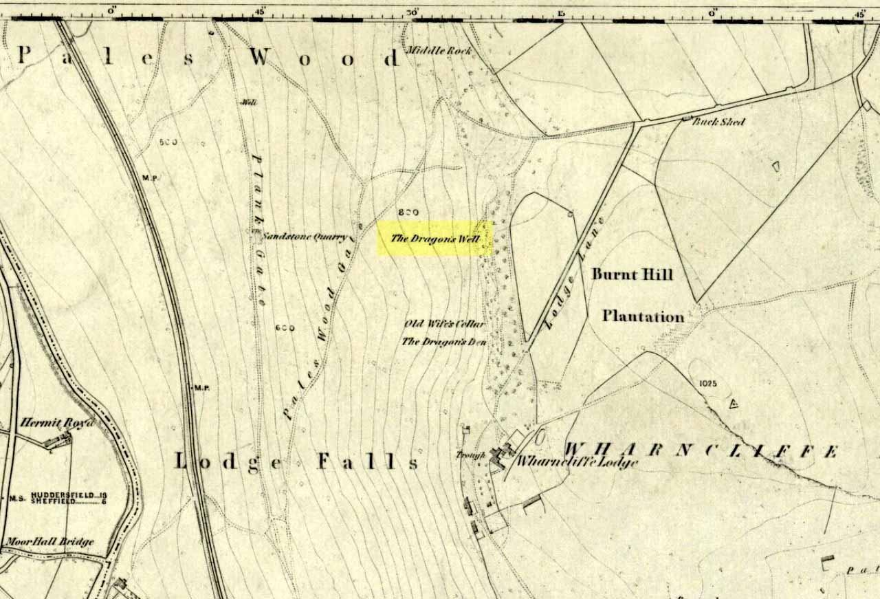
Highlighted on the first OS-map of the area in 1855—along with it’s home and an associated site of the Cailleach, or Old Wife’s Cellar close by—the famous Wharncliffe Dragon used to drink from here, moreso than the other Dragon’s Well at Bolsterstone more than a mile to the west. The dragon – with its “seven heads and twice seven eyes” – lived a short distant away on the rocks above, at the Dragon’s Den. The description of this great beast and its antics at the well were summed-up in Rob Wilson’s book on the Holy Wells of South Yorkshire (1991). He told that:
“The Wharncliffe area has been taken as the setting for the theme of a centuries-old ballad of 19 stanzas , its full title being, ‘An Excellent Ballad of a Dreadful Combat fought between Moore of Moore-Hall and the Dragon of Wantley.’ The 6th and 13th stanzas contain references to Dragon’s Well and are printed below in full:
“Some say this dragon was a witch;
Some say he was a devil;
For from his nose a smoke arose,
And with it burning snivel;
Which he cast off when he did cough,
Into a well that stands by;
Which made it look just like a brook
Running with burning brandy.
It is not strength that always wins,
For wit doth strength excel;
Which made our cuning champion
Creep down into a well:
Where he did think this dragon would drink,
And so he did in truth;
And as he stopp’d low, he rose and cry’d Boh!
And he hit him on the mouth!””
References:
Jewitt, Llewellyn, ‘The Dragon of Wantley and the Family of Moore,’ in The Reliquary, April 1878.
Wilson, Rob, Holy Wells and Spas of South Yorkshire, Northern Arts: Sheffield 1991.
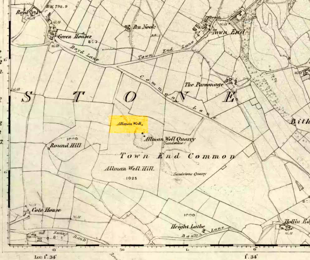
Also known as the Allman’s Well, an inscription with an 1818 datestone was to be found here. But according to folklorists Dave Clarke & Phil Reeder, the site can no longer be found as its waters were “diverted for use at a nearby farm.” However, something that does need checking is their description of a cup-and-ring stone on one of the boulders close by – reckoned to be one of those dropped by the dragon which gives the well its name.
Folklore
Something strange was once going on in this locality if place-names and legends have owt to go by. The local Wharncliffe Dragon, as it was known, used to fly from its home at the Dragon’s Den (a mile-and-a-half east of here) and drink the waters from this well. On one of its flights from Wharncliffe Crags, it carried with it three huge boulders which it dropped in transit and which were said by the folklorists David Clarke and Phil Reeder “to stand in a line on the slope below the well at Townend Common.”
The water from here was said to be good for curing both asthma and bronchitis and was also said never to have dried up, even in the greatest of droughts.
References:
Wilson, Rob, Holy Wells and Spas of South Yorkshire, Northern Arts: Sheffield 1991.
Paul, Danny and I came here via the Feizor village route, zigzagging about, to and fro, seeing the other old sites in the region; but the easier direct way to get here would be from Settle. Walking through Settle, going out of the top end of town, cross the old bridge and take the country-lane on the right, up northwards towards Stackhouse. A mile along the road (shortly before Stackhouse), a footpath on your left veers up diagonally through a small copse of woods. Go up here and out the other side of the trees, the path turns left and up over the fields. Go up here, and over the third wall along the footpath, you’ll see a large overgrown pile of rocks 30 yards in front of you with a large stone laid roughly in its middle. You’re here!
Archaeology & History
This is an excellent though much neglected prehistoric cairn of some considerable proportions, its rocky mass laying half-covered in deep earth and grasses, yet with still a very large section of it open to the elements. The creature is nearly 30 yards across and some 4 yards high — though it’s hard to say with any certainty, where exactly the natural Earth begins and the cairn starts. But from whichever way you look at this large cairn, walking around the overgrown features, you know it’s a big thing — similar in size and nature to the Great Skirtful of Stones on Burley Moor, and the neolithic cairn on Bradley Moor, near Skipton.
Paul & Danny atop o’ t’ pileBear’s photo, looking SW
On the modern OS-map there are 2 ancient cairns marked close to each other — and our “Apronful of Stones” is the lower one of the two.
In recent years the site was described briefly in Dixon’s (1991) Journey through Brigantia, but there’s been very little written about the place in modern archaeological surveys. The first account I’ve found of the site was written by an anonymous “W.F.” in The Gentleman’s Magazine of 1784. In a detailed lengthy essay, the following words were penned:
“This barrow, or tumulus, stands in an elevated situation, upon a mountain, above the hamlet of Stackhouse, and may be discerned at a great distance…
“The form of this vast mass is circular, or rather orbicular ; the height, by computation on the spot, about 9 or 10 feet. It is composed of an incredible quantity of stones, piled in such a manner as to rest upon each other’s basis, and strengthened by its conic form, it rises upwards in this curious shape. Those stones that form the outside of the work are so small that a soldier could carry them; and since it has been argued that such a monstrous work as this would not be attempted by any nation, but was natural, the largeness of the tumulus may easily be accounted for, since they were annually increased out of reverence…
“This barrow had been opened many years ago, and it is represented in the plate in the state in which it has appeared till lately. Some old people in the neighbourhood remember its being entirely complete, and having a very flat top. It was usual, in finishing these works, to lay a flat stone at the top. The people that opened it left their intention unfinished, only throwing down the lid of the stone coffer, and one or two of the sides; and, meeting with nothing worth digging for, they left it. Upon examining it in this state, before its being entirely disfigured in the last attempt, I found several human bones scattered up and down therein, amongst which I selected the patelae of the knee, the vertebrae of the spine, part of the jaw, and several teeth.
“Round the area is a wall or rampart, of the same materials as the outside, its height from the interior part about 2 feet, irregularly ranged with fissured remnants. In the centre of the cavity or area is the above chest, consisting of several huge stones of vast magnitude and density, fixed firmly into the ground, which supported a lid of equal size, though it is now thrown off the top. In this chest are partitions, for what purpose is not known, unless each space was allotted to its particular relique or body. In the partitions and sides of the coffin is a kind of hole in the edge, with a rude mould. (my italics, PB) Not many weeks ago, the curiosity of some of the neighbourhood was excited to investigate this stupendous work of art, and accordingly labourers were hired, when, upon searching a day (yet not half the work done), a human skeleton was found, in due proportion, and in a fine state of preservation, excepting the skull and one of the limbs, which were moved out of their place by the workmen’s tools. A small circular piece of ivory, and the tusk of an unknown beast, supposed to be of the hog genus, was also found ; but no ashes, urns, coins, or instruments were discovered. ”
Many years later the giant cairn was described briefly in William Howson’s (1850) early survey of the district, when he told that,
“Near a gate on the path, where the descent is commenced to Stackhouse, there’s a cairn of eighty feet in diameter; it has not been completely examined, but human bones are commonly found in it.”
But it was more than a century after “W.F.’s” initial essay before another detailed appraisal of the place was given — and that was after a visit here by the legendary Harry Speight (1892) in the latter half of the 19th century. Along with mentioning a number of other prehistoric tombs upon this ridge, Mr Speight told:
“From Settle Bridge you may take the field-path…or the rustic lane to Stackhouse, and where the road divides just beyond Mr Priestley’s pretty house you wind beneath the wood behind Scale House to a gate and stile on the left. Here ascend the field between two large trees, and at the top go over a stile, whence a path leads up the field a good half-mile to a gate which opens into what our remote Celtic ancestors would have reverentially called the ‘Field of the Dead,’ for within this enclosure are traces and remains of human graves which carry us back to the far dim ages of unwritten history. Following the grassy cart-road a short distance you will see on the left a large circular mound thrown up about 30 feet on the south side, and about 10 feet on the north or higher side. There are other mounds of similar and smaller dimensions within the same area, some of which have been examined, but others do not appear to have been disturbed. Many of the barrows or ‘raises’, have at some time or other been carelessly dug into in the hope of finding valuables, and as doubtless in most cases nothing was found but rude chests or coffins, containing bones, these were tossed aside and no record of them deemed worthy of preservation…
“The largest of these existing raises has happily been described by a writer who signs himself ‘W.F.’ in the ‘Gentleman’s Magazine’ for 1784 and 1785. Although his account fills several pages, it is obviously defective in many particulars. We are told that the circumference of the base of the mound is 210 feet, and that its height is 9 or 10 yards, and that the casing is composed of stones “so small that a soldier could carry them,” while the inside is made up of earth and stones, some of the latter being “much larger than the external coating.” In form it was circular…and the diameter of the summit was 45 feet. The barrow he tells us was opened many years ago, but some old people in the neighbourhood remember it being entirely complete, and having a very flat top.
“…Upon examining it in its former state the writer discovered several human bones scattered about the rock and soil, among them the palletae of the knee, the vertebrae of the spine, part of the jaw and several teeth. In the centre of the mound was a cavity containing a chest composed of four upright stones and a lid 6 feet 9 inches long and 3 feet broad. The chest was in partitions, in the edges of which were a kind of hole with a rude mould. The writer, under date, Settle, Nov 23rd 1784, next informs us that, “not many weeks ago the curiosity of some of the neighbourhood was excited to investigate this stupendous work of art, and accordingly labourers were hired, when upon searching a day (yet not half the work done) a human skeleton was found, in due proportion, and in a fine state of preservation, excepting the skull and one of the limbs, which were moved out of their place by the workmen’s tools. A small circular piece of ivory, and the tusk of an unknown beast, supposed to be of the hog genus, were also found; but no ashes, urns, coins, or instruments were discovered.”
Other important prehistoric monuments can be found on the grassy limestone plain beyond the Apronful: these include the fascinating Sheep Scar Enclosure just 180 yards (165m) to the north; an associated prehistoric cairn (one of several) 57 yards further northeast; and a delightful, though overgrown cairn circle 325 yards NNW. Other Iron Age and Bronze Age remains can be found elsewhere within this arena. Archaeologists could do themselves a big favour by exploring this landscape more efficiently than they’ve done so far as other unrecognized sites exist in this area.
Folklore
Big stone in t’ middle
Harry Speight (1892) told us how the place got its name “from a tradition…that his Satanic Majesty, in haste to complete the bridge bearing his evil name near Kirkby Lonsdale, tripped and his apron-string broke which let drop this immense heap.”
Another tradition narrated again by our anonymous ‘W.F.’ in the Gentleman’s Magazine(1785) said how this giant tomb, “was raised over the body of some of the Danes slain in the general massacre of that nation.” He also told, “Such a conspicuous work must certainly be erected to the manes of some chiefs, though there is no ground to support its tradition.”
References:
Dixon, John & Phillip, Journeys through Brigantia – volume 4: Beyond the Hill of Winds – Walks in Upper Ribblesdale, the Three Peaks & Upper Wharfedale, Aussteiger: Barnoldswick 1991.
Ferrand, William, “Stackhouse, Yorkshire,” in The Gentleman’s Magazine (London 1784).
Howson, William, An Illustrated Guide to the Curiosities of Craven, Wildman: Settle 1850.
Speight, Harry, The Craven and Northwest Yorkshire Highlands, Elliott Stock: London 1892.
Many ways to get here, but the easiest for those with cars to is park up on the southeast edge of the hill, at the various scruffy parking bits beside the road at the Nick of Pendle. The view from here is enough to get you going! Walk onto the great hill up to the rounded pap of Apronfull Hill (rather gives it away really!). It’s only a few hundred yards up – about 10 mins up the slope from the road, with awesome views all round once you get there. Tis the small guidance cairn you’re looking at just on the level. You’re there!
Archaeology & History
This would once have been a rather huge cairn/tomb — though when I first found the remains of this place in August 2006, there were no archaeological records describing it that I could find. But there’s very little left of it. The lads who did the quarrying further downhill (where you’ve probably parked your car) are likely to have been the culprits who nicked most of the rocks that once made this huge forgotten tomb. But as you potter about here, it becomes obvious that you’re standing on the much-denuded remains of just such a monument (very similar in size and structure to the more famous Little Skirtful and Great Skirtful of Stones on Burley Moor, or Black Hill round cairn near Skipton). But the remains you can see beneath your feet still give a good idea as to how large it was.
Remnants of the cairn-spoil cover the ground where the monument once stood proud!
You’ll see once you’re stood here that there are hundreds, maybe even several thousands of stones just on and below the ground, scattering a very well-defined roughly circular area measuring at least 21 yards (east-west) by 22 yards (north-south), right by the side of the path. The edges of this ransacked cairn are pretty well defined around the north and eastern sides. Near the centre of the old structure is a very notable ‘dip’ in the ground where it looks as if something has been dug away — though this could just as well be due to the presence of underground water, as indicated by the growth of Juncus grasses. Without an excavation it’s obviously difficult to tell.
Folklore
Twas the following tale which first led my nose to explore this part of Pendle hill. It’s a tale we find at many of our upland tombs, though the record books said there was nowt here! (any myopic archaeologists out there who reckon that folklore has no relevance to their subject, educate one’s self!)
Looking from the Devil’s Apronful towards Jeppe Knave’s Grave
The Devil was having trouble with the folk at Clitheroe Castle (a few miles west) and wanted rid of it. So he picked up various large stones and put them in his apron then threw them towards the castle. Most of them missed, which made him angry and in a rage he accidentally dropped a great pile of rocks on the south side of Pendle Hill, creating the Devil’s Apronful on Apronfull Hill.
In another tale he was said to have stood at the Deer Stones a few hundred yards east of here and threw rocks from there. Perhaps a folk-remnant of where the Apronful stones once came from…? Perhaps not.
Jessica Lofthouse (1976) notes how this old spot was long known by local people as the Devil’s Apronful.
References:
Lofthouse, Jessica, North-Country Folklore, Hale: London 1976.
If you’re a bittova unhealthy dood, give this site a miss, as it takes a bitta getting to! Otherwise, get to the rocks at the very bottom of the Druid’s Altar and walk to the right (east) until you hit the walling a few hundred yards along. Near the bottom of the slope, where the land levels out, there are several lovely moss-strewn boulders in their music of graceful hues. One of them, you’ll see, has water emerging from it base. You’re here!
Archaeology & History
The Druid’s Well
I first visited this old site with the holy wells writer Edna Whelan sometime in the early 1980s, when we went in search of the sacred spring of water known as the ‘Altar Well,’ shown on early maps to be just a short distance beneath the small cliffs called the Druid’s Altar. We didn’t find it! Another visit with Graeme Chappell and Edna (again) sometime later also proved fruitless – but something else was found which we didn’t know about on our first sojourn: the Druid’s Well, or more accurately the Druid’s Spring. (no stone trough y’ see) Not far from the spot that the Altar Well could once be seen, this beautiful spring of sweet water emerges beneath the rich lichen-encrusted boulder, painted with dappled mosses and an overhang of vivid ferns. Tis a fine oracular site, if ever there was one!
The waters run slowly from beneath the great old rock, upon which grows a fine specimen of a birch tree – a truly old thing! And if there was ever any truth about this regions association with the druids, one of their most important sacraments grows profusely here when the season is right: no, not mistletoe (though it can be found sparingly upon the old oaks), but a wealth of the sacred Amanita muscaria, to whose spirit visionary journeys were bestowed.
Close-up of the waters beneath the boulder
The name of the woodlands in which our Druid’s Spring emerges — the Hollin Wood — might also have had some associative relationship with this well, or the Altar above (modern maps call it the Hollin Plantation, as much of the old woods have been felled and copsed by modern man). Place-name texts ascribe this to be the ‘woodland of holly trees’, but during our wander through the woods a few weeks ago (when we got the photos of the Druid’s Well) holly trees were not common. It may be that the Hollin Wood originally derived from ‘holy wood’, as this old well and the Druid’s Altar above would have surely made the site sacred to the druids. Just a thought. We will probably never know (if someone finds out for sure, one way or t’other, lemme know and I’ll amend where necessary!).
References:
Greenbank, Sydney, The Druid’s Altar, Bingley, R.G. Preston: Bingley 1929.
Speight, Harry, Chronicles and Stories of Old Bingley, Elliott Stock: London 1898.
Whelan, Edna & Taylor, Ian, Yorkshire’s Holy Wells and Sacred Springs, Northern Lights: Dunnington 1989.
Various routes to this giant tomb, which happens to be a way off the roads (thankfully!). Probably the easiest way is from the Menston-side: up Moor Lane, turn left at the end, go 200 yards and take the track onto the moor. Just keep walking. If you hit the rock-outcrop nearly a mile on, you’ve gone past your target. Turn back for about 400 yards and walk (south) into the heather. You’re damn close!
Archaeology & History
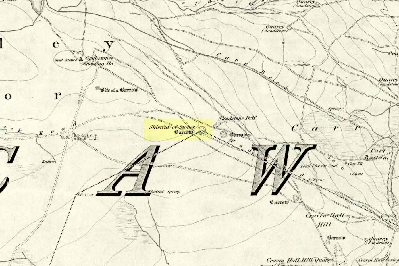
Great Skirtful of Stones cairn looking east to Otley Chevin
Due north of the Skirtful Spring water source, this is one of Ilkley Moor’s major prehistoric sites: ‘major’ for a number of reasons – not least of which is the size of the thing! Although getting somewhat overgrown these days as more of the heathlands encroach the mass of rocks that constitute the central ‘tomb’, it is still a formidable heap. Another reason this site is of importance is its position in the landscape: it can be seen as the peak or ‘nipple’ on the landscape from considerable distances north, south and east of here, rising up on the horizon and catching the eye from many miles away. This was obviously quite a deliberate function of the site when it was first constructed – thought to be in the Bronze or Iron Age period (sadly we have no decent excavation here to tell us just when it was made). Another reason for its importance is its position relative to a once huge prehistoric graveyard immediately east. And right next to it we also find a curious circular monument that has never been properly excavated, whose function is unknown. It is also the seeming focal point of at least one, though possibly three prehistoric trackways: one of which goes right past it, though swerves on its southern edge quite deliberately so as to not touch the monument. This trackway appears to have been a ceremonial ‘road of the dead,’ along which our ancestors were carried, resting for some reason at the nearby Roms Law, or Grubstones Circle, a few hundred yards to the west.
Wrongly ascribed as a “round barrow” by archaeologist Tim Darvill (1988), the Great Skirtful cairn was named in boundary changes made in 1733, where one Richard Barret of Hawksworth told that the site was “never heard go by any other name than Skirtfull of Stones.”
In 1901 there was an article in the local ‘Shipley Express‘ newspaper — and repeated in Mr Laurence’s (1991) fine History of Menston and Hawksworth — which gave the following details:
“Mr Turner led the way across Burley Moor to the Great Skirtful of Stones, a huge cairn of small boulders, nearly a hundred tons on a heap, although for centuries loads have been taken away to mend the trackways across the moor… The centre of the cairn is now hollow, as it was explored many years ago, and from the middle human bones were taken and submitted to Canon Greenwell and other archaeologists” – though I have found little in Greenwell’s works that adequately describe the finds here. Near the centre of the giant cairn is a large stone, of more recent centuries, which once stood upright and upon which is etched the words, “This is Rumbles Law.” The Shipley Express article goes on: “Mr Turner explained that ‘law’ was always used in the British sense for a hill, and Rumbles Hill, or cairn, was a conspicuous boundary mark for many centuries. He had found in the Burley Manor Rolls, two centuries back, that on Rogation Day, when the boundaries were beaten by the inhabitants, they met on this hill, and describing their boundaries, they concluded the nominy by joining in the words, “This is Rumbles Law.””
Great Skirtful on 1851 map
Several other giant cairns like this used to be visible on the moors, but over the years poor archaeological management has led to their gradual decline (and in editing this site profile in 2016, have to report that poor archaeological and moorland management is eating into and gradually diminishing this monument to this day). We still have the Great Skirtful’s little brother, the Little Skirtful of Stones, a half-mile north of here. The very depleted remains of the once-huge Nixon’s Station giant cairn can still be seen (just!) at the very top of Ilkley Moor 1½ miles (2.65km) west.* And we have the pairing of the giant round cairn and long cairn a few miles west on Bradley Moor, near Skipton. The tradition of such giant tombs on these hills was obviously an important one to our ancestors.
Folklore
We find a curious entry in the diaries of the Leeds historian Ralph Thoresby, in the year 1702, which seems to describe the Great Skirtful of Stones, adding a rather odd bit of folklore. (if it isn’t the Great Skirtful, we’re at a loss to account for the place described.) Mr Thoresby told how he and Sir Walter Hawksworth went for a walk on Hawksworth’s land and said how,
“he showed us a monumental heap of stones, in memory of three Scotch boys slain there by lightning, in his grandfather’s, Sir Richard Hawksworth’s time, as an old man attested to Sir Walter, who being then twelve years of age helped to lead the stones.”
As far as I’m aware, this old story of the three Scottish boys is described nowhere else.
Like many giant cairns, the Great Skirtful has a familiar creation myth to account for its appearance. In one version we hear that it was made when the local giant, Rombald (who lived on this moor) and his un-named wife were quarrelling and she dropped a few stones she was carrying in her apron. A variation swaps Rombald’s wife with the devil, who also, carelessly, let the mass of stones drop from his own apron to create the ancient cairn we still see today.
According to Jessica Lofthouse’s North Country Folklore (1976), a Norse giant by the name of Rawmr, “fell fighting against the Britons of Elmet and is buried, they say, on Hawksworth Moor” – i.e., the southeastern section of Rombald’s Moor, very probably at the Great Skirtful of Stones. I’ve yet to explore the history and etymology of the name Rawmr…
References:
Bennett, Paul, The Old Stones of Elmet, Capall Bann: Chieveley 2001.
Cowling, Eric T., Rombald’s Way, William Walker: Otley 1946.
Darvill, Timothy, Ancient Britain, AA: Basingstoke 1988.
Laurence, Alastair, A History of Menston and Hawksworth, Smith Settle: Otley 1991.
* Whoever is/was supposed to be responsible for the care of the Nixon’s Station giant cairn monument should be taken to task as it’s been virtually obliterated since when I first came here 30 years ago. Which useless local archaeologist and/or council official is responsible for its destruction? Who allowed it to happen? Why are Ilkley Moor’s prehistoric monument’s being so badly looked after by those who are paid to ensure their maintenance? Are their heads up their arses, in the sand, or—don’t tell me—the prawn sandwiches are to blame!?
On this curious, broken, basin-shaped rock — thought by some to have at one time played a part in an old cross whose remains are in the Abbey Museum — are two deep cup-shaped hollows, in which were once “three noble globes of white marble” that were used for oracular purposes and were said to have originated in druidical rites. In Miss McNeill’s (1954) survey of the island, she tells that:
“near the edge of the path leading to St. Oran’s Chapel, there lies a broad, flat stone, with a slit and a cavity on its surface. Here there used to lie some small round stones which pilgrims were wont to turn sunwise within the cavity; for it was commonly believed that the ‘brath’, or end of the world, would not arrive until this stone should be worn through.”
The small stones that were once in the Brath were ordered by the Church to be thrown into the sea; but local folk replaced them with three other small stones, maintaining the traditional rites of this stone until they eventually stopped sometime in the 19th century. But in Major-General James Forlong’s (1906) study, he tells of a somewhat earlier mythic origin to this old stone, saying:
“In Iona the Druids are said to have made the flat altar stone called Clachan-nan-Druidhean, or Druid’s Stone, the stone of fate or of the last day, with round stones fitted into cup hollows on the surface, which the pious pilgrim turns round. The world will end when the stone is worn through. The Culdee monks preserved this monument.”
And what little is left is still preserved to this day. The curious “end of the world” motif was something that was grafted onto an earlier mythos: what Mircea Eliade called the “myth of the eternal return”, wherein Nature’s annual cycle —from birth, life to death and subsequent renewal, endlessly, through the seasons—was the original status, later transmuted by the incoming judaeo-christian cult of linear time and milleniumism relating to a literal “end of the world” when their profane myth of Jesus returning to Earth occurs. We might also add that the stones which once rested into the hollows of the Clach Brath would likely have possessed divinatory and healing qualities, as comparatiove studies suggest.
References:
Eliade, Mircea, The Myth of the Eternal Return,
Forlong, J.G.S., Faiths of Man – volume 1, Bernard Quarithc: London 1906.
Holder, Geoff, The Guide to Mysterious Iona and Staffa, Tempus: Stroud 2001.
McNeill, F. Marion, Iona: A History of the Island, Blackie & Son: Glasgow 1954 (4th edition).