Described in Walter Bennett’s (1946) magnum opus as a “stone circle” and repeated in Aubrey Burl’s (2000) magnum opus under the same category, the site here seems more likely to have been an old cairn circle, or perhaps even a simple tumulus — and a small one at that! It was first noted in June of 1842 when the antiquarian, Mr F.C. Spencer of Halifax, “had his attention called to a circle of stones in a field called Delph Hill Pasture by Jonas Lee, a Thursden farmer, and a somewhat noted character in his day” who knew the location very well. It didn’t take long for Mr Spencer to realise that this was “an ancient British barrow,” as he called it, and made plans to excavate the site soon after seeing it.
Following Spencer’s dig, a short account of the finds was made in the Gentleman’s Magazine, telling of the remains of this “small circle of stones” and the burials therein. The account said:
“The circle originally consisted of rock pillars (five of which remain) , standing about 18 inches above the surface, and being about 2 feet square. The diameter of the circle is about 5 yards. Mr Spencer directed an excavation to be made without delay, the result of which was the discovery of two very antique earthen urns, curiously marked, containing fragments of human bones, of small dimensions, mixed with charcoal and black mould. The tops of the vessels were covered with small flat slate-stones, but little larger than the urns, over which larger heavy stones were placed for their protection. The urns were found about 2 feet beneath the surface of the field, in the centre of the circle, embedded in soft clay, with many pieces of charcoal interspersed. About 300 yards from the barrow are the bold remains of a British circular camp…”
A few years later, Tattersall Wilkinson (1893) told that “three unglazed urns, with human remains and flint arrowheads” (my italics) were found at the locale. Curiously there has been some confusion as to the number of urns that were actually found at Delf Hill by different authors over the last 175 years (numbering between 1 and 3, depending on whose account you read!), but it would seem this has occurred due to the proximity of other tombs close by.
An excursion to Delf Hill a few years after Spencer’s first dig is described in an article by L. Clement (1874), where several members of a local history society reported that the mound here consisted of a “small circle of stones, seven in number, fourteen feet in diameter”, that probably surrounded the hillock. One of the stones had been knocked over and moved, so the group took it upon themselves to place the monolith back into what they thought was its original setting within the monument.
Cairns (destroyed): OS Grid Reference – SE 053 261
Archaeology & History
F.A. Leyland’s drawing of the urns
There’s really nowt to see around here nowadays (apart from a lovely view of the hills and the Calder valley), but it seems that not-too-long ago there were several burials in evidence upon this hill. F.A. Leyland (1867) gives a quite detailed account of the urns and their discovery, which have been variously thought of as Roman, then Saxon, then prehistoric — with them finally ascribed as Bronze Age in Watson’s (1952) survey of the region. Not too far away could once be found the legendary Robin Hood’s stone circle, which might have had some relationship with the burials here — though we’ll probably never know for sure! Leyland’s (1867) lengthy notes of this site told:
“An interesting discovery was made in…recent times, of a number of cinerary urns in the township of Warley. The site of the interments was at Tower Hill, a position on a line of military defences which extended from the entrenchments of Hunter’s Hill to Camp End in this township. The urns were found in the process of quarrying for stone; but, owing to the nature of the operations, and the unlooked for discovery of such relics as these or the total absence of all knowledge of their value, by the people employed, many similar remains are known to have been demolished as worthless objects.
“On one occasion, however, an urn, bleached by the tempests of an entire winter, was observed to protrude half its own bulk from the stratum of soil in which it had been originally buried.
“The curiosity of the labourers was excited, and the relic was removed. It was found to contain bones and ashes which the people, ever prone to the marvellous, held to be the remains of a child which had been destroyed by foul means and there buried. This opinion was noised abroad, and the true nature of the interment explained. We examined a fragment of this relic: it was rudely constructed of sun-burnt clay, and was grimed in the inside as if by the smouldering embers of the funeral pyre, and the smoking ashes of the dead, on their introduction to their narrow urn.
“This had been filled with these human exuviæ; and appeared to have been lined with moss mixed with fibres of plants which, after the urn had fallen in pieces, adhered firmly to its contents. It was thirteen or fourteen inches high, and was no doubt made by the hand alone. Within a few yards of this, another urn was found, containing bones and ashes, but so far decomposed as to preclude the possibility of its preservation: near the same place the smaller urn in our illustration was discovered buried in the dark soil peculiar to the locality; it was filled with calcined bones and ashes and, like the one found at Upleton—and in the possession of Dr Young of Whitby—had a small clay vessel placed within it, which is represented in our engraving. The urn was, moreover, protected by a lid, resembling the inverted stand of an ordinary flower-pot: the relic measured six inches high.
“During the winter of 1848, a date subsequent to the above discoveries, there was a fall of earth from the same spot, into the quarry at Tower Hill; the soil, thus precipitated from the moor, impeded the operations of the labourers; and, on its removal, the larger urn of our illustration was brought to light. This relic measured nine inches high and was twenty-two in circumference; but, in the rubbish, there were observed numerous fragments of other cinerary urns, and equally numerous relics of cremation.
“These discoveries lead one to one of two conclusions: either that Tower Hill was the field of some formidable engagement, in which numbers fell; or, that it was used as a place of frequent sepulture by the primitive inhabitants of the locality. It is not at all improbable that these urns were the produce of some local pottery, if not made by the same hand, as the one described by Watson (1775), the patterns indented on the two upper compartments of the smaller vessel being of the same kind, and occupying the same positions as the one referred to.
“The larger urn, as will be observed, is divided like the others into three compartments, the upper one standing out in relief, but having a different kind of decoration resembling herring-bone masonry; while the smaller one of our illustration, and that of Watson, are furnished with a zigzag design. But, although there is this slight variation in the upper moulding of the larger vessel, they all possess the lozenge-shaped decoration in their central compartments.”
We haven’t yet explored this site diligently and also know that if we have to await the slow hand of archaeology here we’d be waiting an aeon, but Tower Hill’s position in the landscape would tend to indicate the latter of Leyland’s earlier suggestions regarding the nature of the finds, i.e., the hill was a prehistoric graveyard, though of unknown size.
References:
Leyland, F.A., The History and Antiquities of the Parish of Halifax, by the Reverend John Watson, M.A., R.Leyland: Halifax n.d. (c.1867)
Roth, H. Ling, The Yorkshire Coiners, 1767-1783; and Notes on Old and Prehistoric Halifax, F.King: Halifax 1906.
Watson, John, The History and Antiquities of the Parish of Halifax, T. Lowndes: London 1775.
Watson, Geoffrey G., Early Man in the Halifax District, HSS: Halifax 1952.
An excellent passage grave tomb that’s been described by many historians over the last two hundred years, and was subject to a fine excavation in the first half of the 20th century. Ascribed as neolithic in origin, recent finds of human activity on the edge of the surrounding henge indicates people have been “up to things” hereby since at least 6000 BC. Deriving its name from “the mound of the black grove,” the site as we see it today has been much restored and is so different to when it was visited by Thomas Pennant and other antiquarians.
According to an anonymously written essay in Archaeologia Cambrensis in 1847, the site was first described by Henry Rowlands (1723) where, in relation to another site, he told were,
“the remains of two carnedds, within a few paces of one another: the one is somewhat broken and pitted into on one side, where the stones had been carried away; the other having had its stones almost all taken away into walls and hedges, with two standing columns erected between them.”
A somewhat more detailed description came from Thomas Pennant a few years later. He wrote:
“A few years ago, beneath a carnedd similar to that at Tregarnedd, was discovered, on a farm called Bryn-celli-ddu…a passage three feet wide, four feet two or three inches high and about nineteen feet and a half long, which led into a room about three feet in diameter and seven in height. The form was an irregular hexagon, and the sides composed of six rude slabs, one of which measured in its diagonal eight feet nine inches. In the middle was an artless pillar of stone, four feet eight inches in circumference. This supports the roof, which consists of one great stone near ten feet in diameter. Along the sides of the room was, if I may be allowed the expression, a stone bench, on which were found human bones, which fell to dust almost at a touch: it is probable that the bodies were placed on the bench… The diameter of the incumbent carnedd is from ninety to a hundred feet.”
Ground-plan
But the main excavation work at Bryn Celli Ddu was done in the late-1920s by W.J. Hemp (1930) and his team, who, as usual following such digs, ended up with just as many questions about the site as they had answers! One of the best descriptions of Hemp’s excavation work was by W.F. Grimes (1932) in an essay he wrote for the East Anglian Prehistoric Society where he gave the following detailed description of the finds:
“The cairn here was circular, with a chamber of some 160ft and an original maximum height of at least 12ft. The chamber is a polygonal structure of large stones augmented…with dry-stone walling, entered on the northeast side by a long passage built in the same way. Many of the stones had been dressed and in the chamber stood a single pillar which had been artificially rounded and smoothed, but which had never actually supported the capstone.
“These features had been more or less apparent for many years. But the reparation work soon showed that this was by no means all. In the first place, it was found that the chamber had been surrounded by four circles of standing stones. The first of these, around the outside of the mound at its base, had disappeared, although early accounts and a single hole found in the course of the work of excavation, are evidence of its existence. The second and third circles were found when the entrance to the passage wall was being cleared. Here the walls of the passage were found to merge into an outer circle of large stones and an inner of smaller, set close together and elaborately packed and sunk in a ditch six feet deep and eighteen wide, enclosing the chamber in such a way that passage, chamber and circles together form a gigantic unbroken spiral, with the chamber itself as an unbroken loop in it. The fourth and innermost circle was in the area enclosed by the ditch (which is represented on the plan by the shaded portion). This consisted of a number of stones of various sizes, irregularly placed and in some cases inclined outwards. Under some of them were deposits of burnt human bones. Lines connecting these stones diametrically were found to intersect at the centre of the monument, directly behind the chamber, and here was found a slab-covered pit which contained an elaborate filling whose purpose is unexplained. Beside the cover-stone of the pit was a second larger slab of grit, lying flat, the faces of which were covered with an elaborate and continuous pattern of spirals, scrolls and zig-zags. The position of this stone is shown beside the central stone on the plan. Of it purpose it can only be said that it was probably magical…
“As if the elaborate features already described thus badly were not enough, a uniform floor of purple clay was found to cover the old natural surface within the area enclosed by the ditch, and there were on the floor, in the ditch, and in many other places extensive traces of fire in the form of burnt patches, blackening and quantities of charcoal. In addition there were outside the entrance, a line of post-holes and remains of walls suggesting the former existence of some kind of forecourt crossed by a temporary barrier. Here also were traces of fire and of elaborate ritual. It must be emphasized of course, that all these features, with the exception of the outer circle of stones and the forecourt, had been completely concealed by the mound, so that they were not visible once the monument was completed… Moreover…the entrance to the chamber had been closed with an elaborate blocking which suggested that once closed the chamber had not been intended to be re-opened.”
Although many questions emerged following the excavation, perhaps that relating to the chronology and evolution of the site (after its ritual use) was most important. The site as we see it today sits within the confines of a henge monument (which should also be given an independent entry account) and once a stone circle. And although present day field evidence is inconclusive about which came first, archaeologists like Richard Bradley, Clare o’ Kelly and others are not without opinion. Bradley (1998) told:
“O’ Kelly argued that there had been two successive monuments on the site. The earlier one was a stone circle, enclosed by the earthworks of the henge. In a later phase this was replaced by a passage grave which was built over the surviving remains of the stone circle, its outer kerb being bedded in the ditch of the older monument.”
But Bradley himself doubts this for various reasons, himself interpreting,
“the sequence at Bryn Celli Ddu is to suggest that in its first phase it consisted of a circular unrevetted mound about 15m in diameter, containing a passage grave. Around the edge of this structure was a stone circle, and beyond that there was a quarry ditch. When the monument was enlarged, not on one occasion but twice, the passage was extended as far as the earlier ditch and a significantly larger mound was bounded by kerbstones.”
Though adding himself that there is also a trouble with this idea! As with many other sites, Bryn Celli Ddu appears to have been aligned to the summer solstice. This notion was first propounded by astronomer Sir Norman Lockyer (1909) in his hugely revised work on the astronomical function of megalithic sites. It was nearly 100 years before any archaeologist got off their backside and tested Lockyer’s original proposal and found the scientist to have been way ahead of them at their own discipline. Not unsurprisingly, archaeologist Mike Pitts (2006) was a bit slow in his gimmicky headline in British Archaeology, where he deemed Steve Burrow’s personal observation as “sensational.” Oh how common this theme seems to be in archaeology. Twenty years previously Miranda Green (1991) posited that the chamber alignment from Bryn Celli Ddu aligned towards “May Day sunrise” — which doesn’t seem to work. And on a similar astronomical note, archaeologist Julian Thomas (1991) thought that five post-holes found some five yards beyond the entrance were somewhat reminiscent of the “A” holes at Stonehenge and related to some lunar alignments, thinking that:
“It seems likely that (they) record a series of observations upon the rising of some heavenly body in order to ascertain its standstill position.”
A point that Clive Ruggles (1999) explored with a little scepticism, pointing out:
“The only possibility is the northern minor limit of the moon, and while the adjacent posts are ranged on the correct side to record the position, say, of the midwinter full moonrise in years before and after the minor standstill, many other interpretations of these posts are doubtless possible.”
There’s been lots written about this place and lots more could be added with various archaeologists showing their relative opinions about the place. But perhaps more worthwhile is a visit to the place, later on, when the tourists have fallen back under a starlit sky…
References:
Anonymous, “Cromlech at Bryn Celli Ddu, Anglesey,” in Archaeologia Cambrensis, volume 2, 1847.
Barber, Chris & Williams, John G., The Ancient Stones of Wales, Blorenge: Abergavenny 1989.
Bradley, Richard, “Stone Circles and Passage Graves – A Contested Relationship,” in Prehistoric Ritual and Religion, edited by Alex Gibson & Derek Simpson (Sutton: Stroud 1998).
Green, Miranda, The Sun Gods of Ancient Europe, Batsford: London 1991.
Grimes, W.F., “Prehistoric Archaeology in Wales since 1925,” in Proceedings of the Prehistoric Society of East Anglia, 7:1, 1932.
Hemp, W.J., “The Chambered Tomb of Bryn Celli Ddu, Anglesey,” in Archaeologia, volume 80, 1930.
Lockyer, Norman, Stonehenge and other British Stone Monuments Astronomically Considered, MacMillan: London 1909.
Lynch, Frances, Prehistoric Anglesey, Anglesey Antiquarian Society 1991.
o’ Kelly, Clare, “Bryn Celli Ddu: A Reinterpretation,” in Archaeologia Cambrensis, volume 118, 1969.
Ruggles, Clive, Astronomy in Prehistoric Britain and Ireland, Yale University Press 1999.
Thomas, Julian, Rethinking the Neolithic, Cambridge University Press 1991.
Go through the village of Stanbury, past the last of the two reservoirs until you’re on the western edge of Ponden. Stop and look up the slopes to your south. This spot was recently found and photographed by Richard Stroud: a curious-looking mound with all the hallmarks of being a forgotten tumulus. We’ve gotta check it out properly though!
Folklore
Although not in the archaeological records (not too unusual in Yorkshire it seems), the site does have some literary references and some all-too-common folklore motifs. Perusing my library for info about another nearby site (the Cuckoo Stones), I found the following said of this place in a rare book by James Whalley called The Wild Moor (1869, pp.103):
“It appears that some hills, as well as dales…have silvery names. There is a hill which is on the right hand on the way from Ponden House to Crow Hill Moor, which is distinguished by the beautiful designation of ‘Silver Hill.’ The hill is surrounded by a wall (I suppose to guard the treasure) and its surface is adorned with trees. Grey-headed men living on the borders of Crow Hill and Lancashire Moors affirm that during the Scotch rebellion here was deposited a large chest of silver, which was hid in the hill. It would appear as if the chest of silver is still there!”
This tradition was echoed a decade later by J. Horsfall Turner, and then again by Halliwell Sutcliffe in 1899, who reckoned the “vast treasure was said to have been buried during the ’45 rebellion,” adding how “the fields which climb this hill were well tilled aforetime through being constantly turned over in search of the treasure” – but nowt was ever found.
An additional bit of folklore tells of two spirits nearby: one of a man; another of a fiery barrel — either a remnant of earlier solar folk traditions hereby, or perhaps just an earthlight. One of these (the fiery barrel) rolled down the hill nearby; whereby the ghost of the man walked by the hillock along the track from Ponden House a little further east.
References:
Horsfall-Turner, J., Haworth Past and Present, J.S. Jowett: Brighouse 1879.
Sutcliffe, Halliwell, By Moor and Fell in West Yorkshire, T. Fisher Unwin: London 1899.
Follow the directions to reach the Dumpit Hill A circle. From here walk about 100 yards ENE till you see an arc of small upright stones. If the heather’s in full growth it’s highly unlikely you’ll see anything; but if the heather’s been burnt away, the site’s worth looking at.
Archaeology & History
As with the small companion Dumpit Hill A circle more than 100 yards to the southwest, this site of similar dimensions was first reported by Arthur Raistrick in 1963, and then described — albeit briefly — in H.G. Ramm’s “Yorkshire Archaeological Register” for 1964, as “33ft in diameter. One third of the circle robbed but other stones standing.” And apart from that (with a repeat of the same info in Burl’s [2000] magnum opus) little else has been said. But there’s quite a bit more to this place than what our mentors have written…
Northern arc of circle, with stones A, B, C & DDumpit B Stone Circle (white sticks showing position of stones)
In a team visit to the site last week, it was Paul Hornby who called our attention to Dumpit Hill B. Thankfully the heather had been burnt back several months earlier, fortunately allowing us a better assessment of the place than Mr Raistrick’s initial survey forty years ago. Instead of just the 3 stones that he found here, we uncovered a near-complete ring of eight stones, arranged in a pretty decent circle (Alexander Thom would have classed it as a Type 1 circle). Paul’s attention was first drawn to an arc of three obvious upright stones and another laid down along the same arc. This arc then turned out to be a semicircle when he found another stone laid half-covered in the peat.
Western stones D & EStone F
But then it seemed, if this was an authentic stone circle, we were gonna struggle to see the rest of it as the deep heather had grown up over the southern side of this semi-circle of stones. But thankfully, with just a little bit of stomping on the ground in the right areas, three other stones of similar size and stature were located and within just a few minutes this small arc of stones had become a full prehistoric ring — except perhaps on the eastern side, where there was a distinct gap in the monument. Michala Potts and Paul did come across a couple of stones in this “missing” section, but they were just small rocks and didn’t account for an expected 9th stone. If such a stone ever stood at this eastern point in the circle, it remains unfound.
Two of the stones (G & H) that were initially covered in heather, after we’d carefully peeled the vegetation back, had what seems like small packing stones at one end, where it seemed obvious they had stood upright. It was tempting to carefully stand each stone back up into position, but we managed to overcome the temptation! None of the stones are higher or longer than 3 feet. At least three of them seemed to have been set along their longer axis rather than being set in the tall upright position — but again, this needs verifying by excavation. (With good evidence, some students posit that upright stones are male; rounded, wider stones are female — though such a lay-out here seems unlikely)
Stone GStone H
An additional curiosity was found in the middle of the circle, where there was a small but distinct scattering of stones, very much like a denuded cairn. If this turns out to be the case (as seems likely) it’d mean a new classification for this monument. We could do with having another look at this place the next time the heather’s been burnt away, enabling us to find out more about its nature and function.
…And if you walk west down the slight slope, over the couple of small drainage-ditch streams (which they really should stop cutting into our moorlands) and then up the slight slope towards the trackway, stopping some 20 yards before it, you’ll find you’ve walked right into the middle of a previously undiscovered Bronze Age enclosure, or settlement: the Dumpit Hill enclosure. It’s pretty impressive aswell! (more on that in due course)
References:
Burl, Aubrey, The Stone Circles of Britain, Ireland and Brittany, Yale University Press 2000.
Ramm, H.G., “Yorkshire Archaeological Register, 1964,” in Yorkshire Archaeological Journal, part 163, 1965.
ACKNOWLEDGEMENTS: Huge thanks again to Dave Hazell, Paul Hornby and Michala Potts in seeking out & helping with this and the adjacent sites!
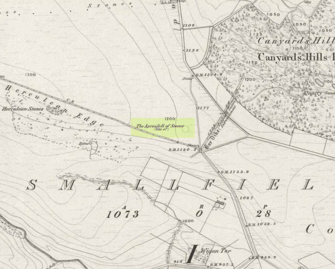
This was another example of the many giant cairns that scatter the upland moors on the Pennines, but much of it has been destroyed, with some halfwits in recent years cutting a track right through whatever remains there might have been! It was first described in John Watson’s (1776) essay on the local antiquities of Bradfield and district where, in relative conjunction with the curious Bar Dike, he told that “this is not the only curiosity on this common.” He continued: “there is on one part of it a large carnedde, called by the country people the Apron-full of Stones”, where he conjectured there laid a British tribal chief after he’d been slaughtered by the Romans. This might have been the folklore of the place, but we know such places were thousands of years earlier than the Romans.
It was later described in Joseph Hunter’s Hallamshire (1819) as a giant barrow, or ‘vast carnedde’, even then in the past tense; but some recent investigation here found “a few small stones and some lumpy turf which looked to be covering a few clumped stones.” The site requires further investigation by local people to assess the state of damage inflicted on this once great tomb.
Folklore
Said to have been the site of a local battle in ancient times; this is also another site which, as A.H. Smith (1961) tells, “is explained in folklore by tales of the devil undertaking some major building project and tripping up, only to deposit his apronful of stones” here. Does anyone out there have any more info on this place?
References:
Hunter, Joseph, Hallamshire: The History and Topography of the Parish of Sheffield in the County of York, Lackington: London 1819.
Smith, A.H., The Place-Names of the West Riding of Yorkshire, Cambridge University Press 1961-63.
Watson, John, “An Account of some Hitherto Undescribed Remains of Antiquity”, in Archaeologia, volume 5, 1776.
Cup-and-Ring Stone: OS Grid Reference – NC 635 384
Archaeology & History
This small cup-marked stone came to light following the work of Mr Angus MacKay of Sutherland, more than 100 years ago. In his essay in the Scottish Antiquaries journal (1905), he wrote the following:
Grumbeg carving
“A cup-marked stone was found by me in the burial place of Grumbeg, Strathnaver, September 1905, standing upright at the head of a grave, and showing about 6 inches above the ground. It is evidently a fragment of a larger slab: its extreme length is 20 inches, and it is about 15 inches at its broadest part. The upper three circles are 2.5 inches in diameter and 1.5 inches deep, very symmetrically hollowed out, but the fourth and lower circle is shallow and indistinct. As the stones covering the other graves are for the most part what is called rough mountain slabs, it seems to me that this cup-marked fragment was found in its present condition elsewhere, and placed here to conveniently show a lair.”
If such was the case, a good contender might be the denuded chambered cairn close by.
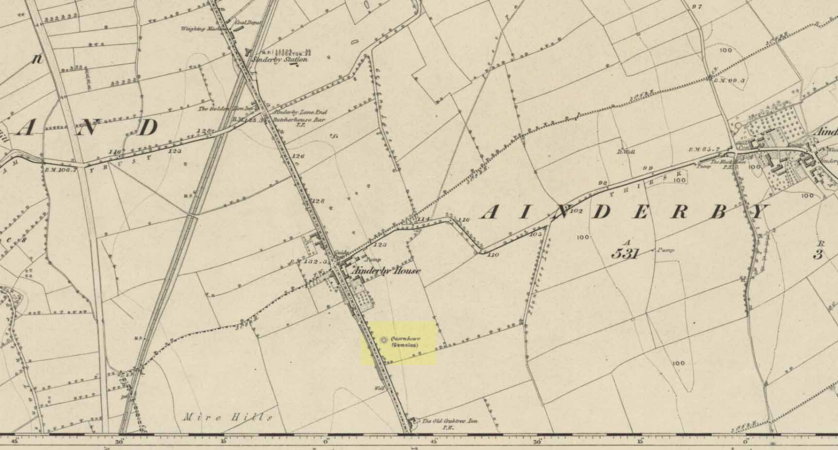
Long since destroyed by the self-righteous advance of the Industrialists, this was a pretty impressive-looking tomb according to the account of D.M. Waterman (1951). Found between the villages of Ainderby Quernhow and Kirklington, right at the side of an important prehistoric trackway—later used by the Romans and known as Leeming Street (on what is now the A1 motorway). Waterman cited it as being “of primary importance in prehistoric times” as it stood on the great plain between the three great henges of Thornborough to the north and those on Hutton Moor to the south, accompanied by a number of other tumuli nearby.
Quernhow tomb on 1856 OS mapThe excavated monument
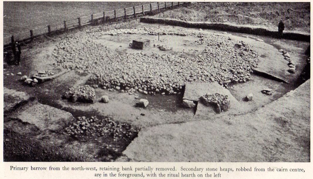
When Waterman and his team arrived here, the barrow “appeared as a low-spread mound, about 3ft in elevation, the exact limits of which were difficult to define,” due to large parts of it being covered over in mud that’d been dumped there by the local land-owner, aswell as erosion due to other farming or industrial activity. But once the archaeologists had stripped the centuries of soil from the damaged surface of the monument, a most impressive site emerged! At the heart of this great burial mound was found “an imposing stone cairn, more or less flat-topped and with a circular constructed face.” He (1951) continued:
“The material of the cairn was composed of cobbles or boulders, all of local geological origin, ranging in size from a few inches up to a foot in diameter or more. A stone considerably larger in size was occasionally encountered , the largest found measuring 23in by 20in and from 3in to 5in in thickness. The stones were heaped up without any deliberate attempt at producing a stable structure and used indiscriminately, irrespective of size or shape, although there was a tendency for the larger stones to occur towards the perimeter of the cairn. Since the cairn itself was built to a flat surface, and the underlying barrow-mound assumed a saucer-shaped profile, the cobbles perforce increased in depth towards the cairn face; at the very centre they were laid one, occasionally two deep, at the face three or four deep, although irregular size and placing precluded any consistency whatsoever in the work. The standard of the building in fact differed considerably throughout the structure. On the northeast and northwest the facing-stones were quite carefully laid, standing to a height of 22in, the work becoming increasingly shoddy towards the south where the construction had so deteriorated that whole sections of the facing had fallen bodily away from the cairn mass, slipping down the tail of the underlying mound…”
Plan of Quernhow
In the middle of the large cairn were found four small pits and a number of small cremations in and around them. There were also found the usual broken remains of pottery, human bones, charcoal, foods vessels and burnt pieces of oak and other vegetation. Near the centre of the cairn was a curious “four poster” of upright stones, “about 1.4ft long and rather less in breadth and thickness (which) suggest, from consideration of their obviously deliberate and careful placing, some significant function in burial ritual.” The four corners of these stones were close to the cardinal points: north, south, east and west.
References:
Waterman, D.M., “Quernhow: A Food Vessel Barrow in Yorkshire,” in Antiquaries Journal, volume 31, 1951.
An intriguing site this, as it doesn’t appear to be in the Canmore archaeological register – unless it’s the Canmore site 34750. Yet Alexander MacGregor (1937) mentions the place in his folklore study as being a site where the little people lived. Shown on the first OS-map of the region as ‘Fairyfold Hillock’, Mr MacGregor (1937) said of it:
“Near the summit of Carmylie Hill is a large barrow or tumulus, which was believed at one time by the natives to be a favourite haunt of the fairies, where, with much splendour, they held their nightly revels. It still bears the name of ‘Fairy-Folk Hillock.'”
However it seems that quarrying operations may have destroyed the site. The tomb here was probably the same one described by Mr Andrew Jervise in the Journal of the Kilkenny and South East of Ireland Archaeological Society (1864-66), where he wrote:
“Many years ago I took note of another example of these ‘footmarks,’ which was found in the parish of Carmyllie… This was discovered in the course of making agricultural improvements some thirty-five years ago, on which occasion stone coffins or cists were got, and in one of these was a bronze (?) ring, of about three inches in diameter, now said to be lost. Apart from the cists there was a rude boulder of about two tons weight; and upon the lower side of it, as my informant told me, was scooped the representation of a human foot. This too was associated with the elves; for the hillock upon which these discoveries were made was called the ‘fairies’ knowe;’ and tradition says that, but for a spirit that warned the workmen to suspend operations when they began to prepare for the foundations of the parish church, the church would have been built upon that spot!”
This is an intriguing find inasmuch as cup-marked stones are rare in this part of the British Isles. Antiquarians have noted examples of such carvings in the Cornish townships of Davidstow, Delabole, Portreath, but very few others are known about. But in the once-impressive Tregulland Burrow barrow that was found here on the south-side of the road a few hundred yards up from Cold Northcott, just next to the old township boundary line, as many as eighteen carved stones were unearthed!
Fig.2
They were all found inside different sections of the barrow, which was built on top of an earlier cairn structure, which appears to have been built upon an even earlier concentric ring of upright wooden poles. The cup-marked stones appear to have been introduced, or etched, around the time when the cairn structure was laid on top of the concentric ring of stake-holes. This “tradition” of adding cup-marked stones to cairns is a feature found at a number of sites in the northern lands of Yorkshire, Northumbria and across the Scottish counties, but such a celebrated event as this in the far southwest is highly unusual! (although the custom is pretty universal and is found, not only in the UK, but in many parts of the world).
Fig.3Fig.4
In Paul Ashbee’s (1958) excellent essay on this prehistoric tomb, he described the carvings at some considerable length — which is unusual for an archaeologist of that period — noting them as the “cup-marked and ornamented stones”. I hope that people won’t mind me repeating his lengthy notes on the relevant carved stones found in the tomb, the largest of which was on a big slab near the middle of the cairn that possessed cup-markings “and an ‘eyebrow’ motif”,* (figure 1, above) as he called it. He described the respective carvings as follows:
“From the Cairn-Ring:
1-2. A hog-backed outlined slate slab (figure 1, above). The bottom has a straight worked edge which suggests that the form was deliberate. On the inner face are four close-set cup-marks, and an ‘eyebrow’ device which has been made around a natural flaw, whilst the outer half has been formed by pecking and bashing to remove an appropriate amount of the laminated slate structure to form a depression. On the outer face there are four widely set cup-marks, one being connected by a channel to the edge of the slab…
3-4. A roughly rectangular slate slab. The upper face bears two cup-marks, one much smaller than the other, together with one abortive cup-mark, the lower a single cup-mark. Four perforations had been used to remove this slab from a parent block, the halves of these perforations gracing the upper edge. The slab was incorporated in the upper part of the cairn-ring material stacked against the largest of the sub-megalithic blocks of the cairn-ring.
5. The slab is hog-backed in outline, resembling No.1 above in general form. On the upper face, at a right-angle to the straight bottom edge, a channel had been produced by pecking, the marks of a pointed instrument being clearly discernible at the bottom of the channel. This channel extends almost from edge to edge of the slab, being narrow at the bottom and then expanding, being thus wider and then gradually tapering. Were it not asymmetrical it could be considered as a dagger representation.
6. A small block of roughly pentagonal outline, one side being irregular. The device it bears has been made by pecking an outline and removing the intervening laminated slatey rock. Found at the base of the cairn-ring on the south side.
7. A weathered pillow-like lump of a coarse sandstone-like rock. The plane face bears at least seven small ‘cup-marks.’ On other sides there are more weathered and uncertain marks which may well be natural. It was found surmounting, in a central position, the faced walling on the western side of the cairn-ring. Dr F.S. Wallis reports that: “This is evidently a sandstone rock with a large amount of quartz. This is a very generalized rock and I am afraid that it is not possible to tie it down to any particular part of Cornwall. The rock is much weathered and, judging from the print, I should say that the pits are entirely natural. Such a rock would hardly contain fossils and thus the pits could not have an organic origin.”
8. A roughly rectangular slate slab with opposing ‘cup-marks’ broken through before complete perforation. In addition there is a single cup-mark on the upper edge. (see figure 2) It was in the banked stones on the western side of the cairn-ring.
“From the soil bank:
1. An even, rectangular slab bearing a group of three cup-marks in one corner, and single cup-marks in two other corners. (see figure 3) From the outer cup-marks of the group run two channels. A channel runs from one of the solitary corner cup-marks. It was found, cup-marks and channels uppermost, almost exactly above the satellite cremation trench-grave.
2. A roughly triangular slab, bearing on its upper face a single centrally set cup-mark. Found by the cairn-ring in the eastern quadrant.
3. A small slab, of pentagonal outline, bearing a single shallow cup-mark. Found by the cairn-ring in the eastern side.
4. A thin U-shaped slab which has been battered into shape by edge chipping. A concavity has been made along the upper edge.
“From the ditch infilling:
5. A tough, quartz-veined slab with a shallow battered cup-mark. From the western side of the barrow.
6. A small, tough, even, rectangular piece of slate, bearing an abortive cup-mark. From the western side of the barrow.
7. A thin piece of slate bearing a small cup-mark set at a point where laminae of slate have left the piece. From the eastern side of the barrow.
“Unstratified:
All the “unstratified” cup-marked slabs recovered from the central disturbances, both recent and earlier, may well be derived from the destruction of the central grave arrangements.
8. A thick lozenge-outlined slab bearing one large cup-mark, and one smaller set side-by-side. (figure 4, above)
9. A roughly square-outlined slab with two cup-marks of even size set across one diagonal. (figure 5, below) One cup-mark has a smaller one close by it.
10-11. Irregular pieces of thin slate, bearing traces of perforations on their edges, one bearing cup-marks.
12. A roughly triangular slab bearing an ? unfinished cup-mark.
13. An even hexagonal slab that appears to have been, by edge trimming, worked into this form.”
Fig.5
The prolific collection of cup-marked stones in this once-impressive monument would probably indicate that the character buried here was of some significance to the local people, both to those who knew him and, evidently, in the subsequent mythologies surrounding the site (click here for the details of Tregullan Burrow barrow if you wanna know the archaeology and structure of the site). And although we find, statistically speaking, a lacking of other cup-markings in this region, it’s more than likely there are others that are hiding away amidst other old tombs and rocks…
References:
Ashbee, Paul, “The Excavation of Tregulland Burrow, Treneglos Parish, Cornwall,” in Antiquaries Journal, volume 38, 1958.
* the eyebrow motif description was used by a number of archaeo’s for sometime following publication of O.G.S. Crawford’s book, The Eye Goddess, to which the Antiquity Journal editor speculated some cup-and-rings may have owed their origin.
")
")