If you wanna drive here, be prepared for a long uphill winding haul, with very poor turning, single-track roads and no parking spots. It’s dodgy as hell! But, if y’ must – from the central roundabout in Todmorden, take the road diagonally across as if you’re going to the train station, and barely 50 yards up, take the right turn under the railways arches, bearing sharp left, then up the very steep zigzagging dangerous road for a mile or so. You’ll eventually reach Stones Lane on your left. Go down this, nearly to the end, slowly – and keep your eyes peeled until you see the big one! You can’t miss it! If you want walk up (a much safer, healthier and preferable route), take the Calderdale Way route up past Dobroyd Castle, and where you get to the top of the hill and the fields open up ahead of you, look down the slope into the field for one stone, and up past the shrubs to Centre Hill. You can’t miss them!
Archaeology & History
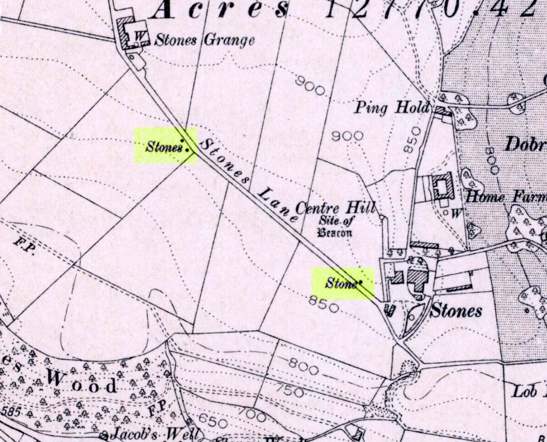
Three ‘stones’ on 1911 map
This is a quite extraordinary sight to those who visit here for the first time. Moreso because, until very recently, the place was excluded from all text-books and surveys. But if you like your megaliths, this place is well worth the trek up the hill. You’ll be amazed! The tallest and largest of these giant monoliths was recorded when a team from Ordnance Survey mapped the area in 1844, but gave no antiquated note to it. When another Ordnance Survey team re-surveyed the area again in 1911, they noted two other ‘stones’ three fields away to the northeast. More than a decade later, the industrialist historian Abraham Newall (1925) described them at some length in his fine work on the region.
Stone 1, looking NWStone 2, at top of hillock (soz about the crap picture)
The first thing generally noticed is the 12-foot tall standing stone near the bottom of the field (stone 1). Then you’ll see the curiously-worked thin standing stone, nearly as tall, on the hillock at the top of the same field (stone 2). This stone has been surmounted onto an old millstone and the hillock itself was once an old beacon hill. Then on the other side of the road a few hundred yards along, another stone just over 4-feet tall can be seen (stone 3); and in the same field is another one laid down at the side of a well (stone 4). This stone used to stand just where the water appears. It’s seems probable that other standing stones may once have been in close attendance, but have been destroyed over time.
Stone 3, looking southStone 3, looking west
Stone 1 is hemmed in at the base by several stones, giving the impression that it was resurrected at some time in the recent past. Several local stories attest to this. Stone 2 was once further down in the same field but was moved to its present position in the 19th century and was, it is alleged, moved there to commemorate the Battle of Waterloo. Several local historians contest this. Stone 3 has nothing said of it; apart from by the local farmer who said it once had a companion (as illustrated on the early map, above). We were told that this companion (stone 4) was uprooted and a spring of water appeared where it stood, so they laid it down in the position it still occupies, just by the spring 10 yards into the field.
If you’re into megaliths and live in Yorkshire or Lancashire, check these beauties out! Just respect the local farmer – he’s not into ignorant tourists clambering over walls. (don’t say you’ve not been warned!)
References:
Bennett, Paul, The Old Stones of Elmet, Capall Bann: Milverton 2001.
Newell, Abraham, A Hillside View of Industrial History, J. Bentley: Todmorden 1925.
Various ways to get here. Probably the easiest is via the golf course itself, walking up towards the top where the trees reach the hills, but keeping your eyes peeled for the large archetypal tumulus or fairy mound near the top of the slope. Alternatively, come up through the wooded slopes from Bridge of Allan and onto the golf course, keeping your eyes ready for the self same mound sat in the corner by the walls. You can’t really miss it to be honest!
Archaeology & History
This is an impressive-looking burial mound sat, intact, on the edge of those painful golf courses that keep growing over our landscape — and you can see for miles from here! It would seem to have been placed with quite deliberate views across the landscape, reaching for countless miles into the Grampian mountains north and west across the moors of Gargunnock and Flanders towards Lomond and beyond…
Fairy Knowe, facing westSir Armstrong’s old drawing
The Fairy Knowe was first excavated in 1868 by Sir J.E. Alexander and his team, when their measurements found it to be some 80 yards in circumference, 78 feet across and 21 feet high — compared to less than 60 feet across and only 8 feet tall today. The findings were recorded in one of the early PSAS reports, and more recently a synopsis of the account was made of it by the Royal Commission (1963) lads who summarized his early findings and told:
“The excavation revealed a cist in the centre of the cairn, laid on the original surface of the ground and measuring 2ft 6in in length, 1ft 6in in breadth and 3ft in depth. Its walls were formed partly of upright slabs and partly of small stones laid horizontally, while the floor and the roof each consisted of a single slab. Within it there was a deposit, 6in in depth, of black earth, charcoal and fragments of human bone among which pieces of a skull were conspicuous. The cist was covered by a heap of large stones, 8ft in diameter and 13ft in height, and this in turn was covered with earth, in which there were charcoal, blackened stones, fragments of human and animal bones and unctuous black earth. Among these remains were found six flint arrowheads, a fragment of what was once thought to be a stone spear-head, and a piece of pine which, it was suggested, might have formed part of a spear-shaft.”
Also, near the top of the cairn in the fairy mound, Sir Alexander’s team located a prehistoric beaker vessel and fragments of what they thought were other beakers pots. Archaeologist Richard Feachem (1977) also mentioned this site in his gazetteer, simply copying the words of previous researchers.
Other prehistoric cairns can be found nearby: one in Cuparlaw Woods less a mile north; plus the Pendreich cairns on the edge of the moors just over 1 mile to the northeast.
Folklore
Obviously an abode of the faerie folk in bygone times, the tales of the place are sadly fading from local memory… Mr Alexander (1868) thought this place may have been an important site for the Pictish folk, and he may well have been correct, as the legendary hill of Dumyat (correctly known as Dun Myat) 2 miles east of here has long been regarded as an outpost of one Pictish tribe.
The main piece of folklore attached to this place relates to its very name and how it came about. In R.M. Menzies (1912) rare work on the folklore of the Ochils, he narrates the local tale that used to be spoken, which describes a procession here from the Fairy Well, just over a mile to the east. Whether this folktale relates to some long lost actual procession between the two sites, we don’t know for sure. Mr Menzies told:
“Once upon a time, when people took life more leisurely, and when the wee folk frequented the glens and hills of Scotland, there was one little fairy whose duty it was to look after certain wells renowned for their curative properties. This fairy was called Blue Jacket, and his favourite haunt was the Fairy Well on the Sheriffmuir Road, where the water was so pure and cool that nobody could pass along without taking a drink of the magic spring. A draught of this water would have such a refreshing effect that the drinker could go on his journey without feeling either thirsty or hungry. Many travellers who had refreshed themselves at the Fairy Well would bless the good little man who kept guard over its purity, and proceed upon their way dreaming of pleasant things all the day long.
“One warm day in June, a Highland drover from the Braes of Rannoch came along with a drove of Highland cattle, which he was taking to Falkirk Tryst, and feeling tired and thirsty he stopped at the Fairy Well, took a good drink of its limpid water, and sat down beside it to rest, while his cattle browsed nearby. The heat was very overpowering, and he fell into a dreamy sleep.
“As he lay enjoying his noonday siesta, Blue Jacket stepped out from among the brackens and approaching the wearied drover, asked him whence he came. The drover said:
“‘I come from the Highland hills beside the Moor of Rannoch; but I have never seen such a wee man as you before. Wha’ may you be?’
“‘Oh,’ said the fairy, ‘I am Blue Jacket, one of the wee folk!’
“‘Ay, ay man, ye have got a blue jacket, right enough; but I’ve never met ony o’ your kind before. Do ye bide here?’
“‘Sometimes; but I am the guardian of the spring from which you have just been drinking.’
“‘Weel, a’ I can say is that it is grand water; there is no’ the likes o’t frae this to Rannoch.’
“‘What’s your name?’ asked the fairy.
“‘They ca’ me Sandy Sinclair, the Piper o’ Rannoch,’ was the reply.
“‘Have you got your pipes?’ asked Blue Jacket.
“‘Aye, my mannie, here they are. Wad ye like a tune? Ye see there’s no’ a piper like me in a’ Perthshire.’
“‘Play away then,’ said Blue Jacket.
“Sandy Sinclair took up his pipes and, blowing up the bag, played a merry Highland reel. When he finished, he was greatly surprised to see above the well a crowd of little folk, like Blue Jacket, dancing to the music he had been playing. As he stopped they clapped their little hands and exclaimed, ‘Well done Sandy! You’re the piper we need.’
“Thereupon Blue Jacket blew a silver whistle, which he took from his belt, and all the wee folk formed themselves into a double row. Blue Jacket then took the Highland piper by the hand, led him to the front of the procession, and told him to play a march. Sandy felt himself unable to resist the command of the fairy, and, putting the chanter into his mouth, blew his hardest and played his best, marching at the head of the long line of little people, who tripped along, keeping time to the strains of the bagpipes. Blue Jacket walked in front of the piper, leading the way in the direction of the Fairy Knowe.
“Sandy Sinclair never marched so proudly as he did that day, and the road, though fairly long, seemed to be no distance at all; the music of the pibroch fired his blood and made him feel as if he was leading his clansmen to battle. When the Fairy Knowe was reached, the wee folk formed themselves into a circle round the little hill, and sang a song the sweetest that ever fell upon the ears of the Highlandman. Blue Jacket once more took his whistle and, blowing three times upon it, held up his hand, and immediately the side of the knoll opened. Bidding the piper to play on, Blue Jacket led the procession into the interior; and when all were inside, the fairies formed themselves into sets, and the piper playing a strathspey, they began dancing with might and main.
“One dance succeeded another, and still Sandy played on, the wee folk tripping it as merrily as ever. All thoughts of Sandy’s drove had gone quite out of his head, and all he thought of now was how best to keep the fairies dancing: he had never seen such nimble dancers, and every motion was so graceful and becoming as made him play his very best to keep the fun going. Sandy Sinclair was in Fairyland, and every other consideration was forgotten.
“Meanwhile his cattle and sheep were following their own sweet will, the only guardian left to take care of them being his collie dog. This faithful animal kept watch as well as he could, and wondered what had become of his master. Towards evening another drover came along with his cattle for the same tryst. He knew the dog at once, and began to pet the animal, saying at the same time, ‘Where’s your master, Oscar? What’s become o’ Sandy?’
“All the dog would do was to wag his bushy tail, and look up with a pleading air, as if to say, ‘I don’t know; will you not find him?’
“‘My puir wee doggie, I wonder what’s come over Sandy? It’s no like him to leave his cattle stravaiging by the roadside. Ay ay man; and at the Fairy Well too! Indeed, this looks unco bad.’
“The newcomer, who was also a Highlander, made up his mind to spend the night with his own drove and that of Sandy Sinclair, thinking that the missing man would turn up in the morning. But when the morning came there was no sign of Sandy.
“Taking Sandy’s collie and leaving his own dog in charge of the combined droves, he said, ‘Find master, Oscar!’ The wise beast sniffed around for a little and then trotted off in the direction taken the day before by Sandy Sinclair and the fairies. By and by they reached the Fairy Knowe; but there was nobody there as far as the drover could see. The dog ran round and round the knoll, barking vigorously all the time, and looking up into the face of the drover as if to say, ‘This is where he is; this is where he is.’ The drover examined every bit of the Fairy Knowe, but there was no trace of Sandy Sinclair. As the drover sat upon the top of the Fairy Knowe, wondering what he should do next, he seemed to hear the sound of distant music. Telling the faithful dog to keep quiet, he listened attentively, and by-and-by made out the sound of the pibroch; but whether it was at a long distance or not, he could not be certain. In the meantime, the dog began to scrape at the side of the mound and whimper in a plaintive manner. Noticing this, the drover put his ear to the ground and listened. There could be no mistake this time: the music of the pibroch came from the centre of the Fairy Knowe.
“‘Bless my soul!’ exclaimed Sandy’s friend. ‘He’s been enticed by the fairies to pipe at their dances. We’ll ne’er see Sandy Sinclair again.’
“It was as true as he said. The Piper of Rannoch never returned to the friends he knew, and the lads and lasses had to get another piper to play their dance music when they wished to spend a happy evening by the shore of the loch. Long, long afterwards, the passers-by often heard the sound of pipe music, muffled and far away, coming from the Fairy Knowe; but the hidden piper was never seen. When long absent friends returned to Rannoch and enquired about Sandy Sinclair, they were told that he had gone to be piper to the wee folk and had never come home again.”
There is some confusion as to whether this mound of earth, barely four feet high but some 50 feet across, is actually prehistoric. But the folklore has that common ring to it, found at olde sites from Cornwall to northern Scotland, speaking of old tombs and ancient ways…
Folklore
In modern times apparently, earthlights have been reported flitting about around this earthen ridge, but the old mound has older, more familiar tales spoken of it. In Rev. Williams’ (1901) article on the folklore of Stirlingshire, he made a considerable detour to tell of some old faerie-lore he’d heard when he was younger, from the prehistoric tomb on the northern side of Elphillock, a few miles south of Kildrummy. In talking with some of the local people about old beliefs, one local man told him:
“The fairies of my native parish made their abode in a round knoll, known as Elfhillock. My friend, James Smith, now no more, was ploughman at Cairncoullie, in the neighbourhood. Passing the hillock one evening, he heard the sound of music and dancing. James drew near to the spot and saw the revels. He waited and enjoyed himself for a short space and then returned to Cairncoullie and went to bed. He found to his amazement that he had been away a year and a day! Every field on the farm and the new ploughmen bore evidence to the fact; and Jamie believed till his dying day that he was a year older than he was aware of, and all because he had given heed to matters he had no business with.”
Not only were the little people said to live within this small tomb, but the hillock must also be cared for and never damaged. Rev. Williams also narrated that the grandfather of the same local man told him that he had,
“pulled some heather from this elf hillock. He was compelled by the women to replace it, otherwise he would have to encounter the wrath of the fairies.”
Thankfully the old hillock is still here, just off the roadside. Not far from here are a number of other prehistoric sites with faerie and ghost-lore and mythological place-names, long since fallen into memories old…soon to be lost perhaps…
References:
Williams, George, “Local Superstitions,” in Transactions of the Stirling Natural History and Archaeological Society, 1901.
Settlement (destroyed): OS Grid Reference – NS 086 635
Archaeology & History
Pottery remnants
Somewhere beneath the modern cemetery and adjacent factory close to St. Mary’s church on the southern outskirts of Rothesay, right by the roadside, was once an important prehistoric settlement. All remains of the site however, have long since been destroyed. An axe that was found here was held in the local museum. There are several scattered accounts of the place, one of which was written by J.G. Scott (1968), who reported that,
“between 1914 and 1929, a series of finds — pottery, a polished stone axehead, a saddle quern, hearths and remains of shallow trenches — was made at Townhead…at a now disused gravel pit. Excavations in 1929 revealed several slots in the original gravel surface, which suggested the remains of sleeper beams for wooden buildings. All the pottery recovered was neolithic… Amongst it were sherds of two vessels of Rinyo-Clacton ware. Most of the rest of the pottery…showed well-developed rims, often thickened and bevelled externally and sometimes everted. This pottery recalls the Abingdon style of southern Britain, and has been termed Rothesay ware by the writer.
“Sherd from one of these Rothesay vessels were associated with charcoal, possibly from a hearth, with hazel-nut shells and small fragments of bone.”
Scott told that radiocarbon analysis dated the finds at around 2120 BC. A couple of hundred yards away are the enclosed remains of St. Mary’s Holy Well, whose waters may well have been of magickal repute all those centuries ago…
References:
Scott, J.G., “A Radiocarbon Date for a West Scottish Neolithic Settlement,” in Antiquity journal, volume 42, no.168, December 1968.
The Hades hill cairn/barrow is located high on the moors some 3 miles north-east of Whitworth and the smaller village of Facit, near Rochdale. Its exact location is close to a footpath halfway between Hades hill and Rough hill, though it is not mentioned on modern OS maps. It is quite difficult to get to so be ready for a long hard walk.
Archaeology & History
This small, low barrow or cairn — a couple of miles north of the little-known Man Stone — measures 15 metres north to south, 13 metres east to west and is 0.9 metres high (about 3 feet in height). But not a great deal can be seen today.
It was excavated in 1898 when a number of artefacts were discovered near the centre of the barrow. The most famous of these ancient artefacts was a Celtic two-tiered urn (of the Pennine type) which had rope imprints and chevrons; inside this urn were the burnt bones of a female, flints, a scraper and a fine pointed borer. Other stuff that came out of the barrow included animal bones, charcoal, flint implements and an arrow head. The urn was placed in the hands of The March Collection at The Rochdale Free Library (now known as Touchstones). A more recent excavation was carried out in 1982 but nothing was recorded at this time. In Dr Whitaker’s History of Whalley, he described there being “the remains of a large beacon, with the foundations of a large circular enclosure” on Hades Hill.
Takes a bitta finding this one! Take the B6265 road north out of Skipton, and about a mile along, turn left up the small road to Stirton village. But once on the level and the open countryside opens to your right, where there’s a notable bend in the road and a track goes up into the field, stop! Walk up past the closed fields and, where the open country starts, veer to the left track (not up the official footpath). Keep walking up here till you’re approaching the bend in the old walling; but veer into the grasses, right, about 50 yards before it. Good luck!
Archaeology & History
Very recently, Mr Paul Hornby called us to come and check a number of features he’d come across on a portion of open countryside not far from Skipton. At the very least it was gonna be a nice day out, ambling abaat and seeing some potentially new prehistoric sites — and we weren’t to be disappointed!
Close-up of cupsSingle cup-mark nearby
Although this site aint much to write home about, it is found close to a number of other recently rediscovered prehistoric features. Upon a fairly large stone a coupla hundred yards east of a supposed tumulus to the southern ridge of Sharp Haw, we find an arc of three cup-markings on the rock’s northeastern face, with a possible fourth cup along the same line (though I aint sure misself). And that’s it I’m afraid. Nowt else. (and I’ll try getting some better images when we’re next up there) Another stone nearby to the west has a near-perfect single cup-marking on its flat surface.
ACKNOWLEDGEMENTS:
Huge thanks to Paul Hornby for the use of his photos!
Take the road up to Brimham Rocks from Summerbridge; crossing the little crossroads, then keep your eyes peeled for the singular farmhouse on your right. Just beyond this, on your right, you’ll notice some small moorland opens up and reaches gently down the slope for some distance. Go along the footpath for 100 yards or so, then into the heather to your right, for 60 yards or so (as if you walking towards the farmhouse and small crags). This is where the following sites could be found. (when we visited Brimham recently, unfortunately sunfall stopped us having a proper wander here, so the status of the site/s remains unknown to us)
Archaeology & History
This little-known and possibly destroyed prehistoric site — less than a mile north of Standing Stone Hill and just a coupla hundred yards south of the legendary Brimham Rocks — has been described by several antiquarians from the early 19th century onwards. It’s an intriguing place, deserving of much greater antiquarian attention. Ely Hargrove (1809) appears to be the first who mentions prehistoric tombs here, though his sense of direction implies another site (unless he just got that part of it wrong?). Along with “several small tumuli or carns” near another section of Brimham Rocks themselves, he told there to be,
“Several large tumuli; one of which about 80 yards west of the great Cannon, measures 150 feet in circumference. It is worth remarking that the place where most of these tumuli are found is, at this day, called Graffa Plain, i.e., the Plain of Graves.”
These ‘tumuli’ were again mentioned briefly in passing by one ‘D.N.H.’ in the Gentleman’s Magazine of November 1823. The great Knaresborough historian William Grainge also described cairns here. They were then highlighted on the very first Ordnance Survey of the region in the 1850s and shown as “Supposed tumuli.” Eventually, at the turn of the 20th Century, they were explored at the behest of the local land-owner by Mr L.A. Armstrong. His description of what they found here is intriguing and well worth reproducing in full:
“By permission of the Right Hon. Lord Grantley, I was enabled to make a careful examination of two of the ancient burial mounds of ‘ Graff a Plain,’ Brimham Moor, on Tuesday, August 4th, 1908.
“Mound No. 1, of circular form, and about 12′ o” in diameter, is situated about 150 yards north-west of the first large group of rocks, upon the south-eastern boundary of the moor, and about 50 yards south-east of the trackway leading to ‘ Riva Hill Farm,’ and it occupies the summit of a slight hillock, upon a comparatively level portion of the heath, which rises rapidly to the south of it in a bold sweep, terminating in the outstanding rocks of Graffa Crags and Brimham Beacon.
“The entire absence of any heather upon the mound, and the profusion of bright green bilberry plants which covered it and at the same time rendered its outline more noticeable, told plainly of a different character of subsoil from that of the surrounding moor ; but prominent as the mound appeared, its actual elevation was deceptive, being barely two feet above the natural level, and the uneven character of the upper surface suggested previous disturbance to be more than probable. A few attempts to pierce the crown, however, proved it to be a cairn, constructed of large stones, and accounted for the prolific growth of the rock-loving bilberry which overspread it, as well as for the uneven character of the surface.
“The thick green covering was carefully stripped off in lengths and placed on one side, and the few inches of vegetable earth removed, revealing the cairn in an almost perfect state, formed of a series of large stones placed methodically in concentric rings, each stone slightly inclined towards the centre, and the whole mass interlocked together by their own weight. Large stones were placed around the outside forming the enclosing circle, which is almost invariably found in the case of earth-built tumuli, and a few of these had been visible before the covering was stripped.
“The construction of the cairn rendered it necessary to remove the stones from the outer ring first, and to work gradually towards the centre where the burial, if such existed, might be expected to lie. This proved no easy task, as the stones were so tightly wedged, and had each apparently been specially selected for the purpose. Almost without exception, they were about a foot in diameter, oblong or oval in form, and three to five inches in thickness, with flat surfaces and rounded edges. No marks of tools were visible on any, but all alike were either water-worn, or had been especially rubbed to their present form. The stone itself was the Millstone Grit of the surrounding moor, but fragments of stone of the form composing the cairn are not now to be found thereon readily, although a careful search might reveal such. Personally I am inclined to think that they have been transported from a considerable distance; that great care has been exercised in their selection is indisputable.
“When nearing the inner radius of the cairn, small fragments of charcoal were noticeable, but they were by no means in large quantities. There was also a layer of fine grey sand an inch or two in depth, which had apparently been spread over the natural surface of the ground, and the stones bedded therein. Sand of this kind is abundant in the vicinity of the rocks upon the moor.
“In the centre, large pieces of stone were piled around a rough circle of about 3′ 6” extreme diameter, and within these, large and small stones, all of the form previously noticed, were laid more or less upon their flat surfaces, and amongst them the grey sand and charcoal were very evident; pieces of the latter up to an inch square, being found.
“Upon the gradual removal of this central mass of stones, the presence of the unmistakable black ‘barrow earth’ became evident in a slight layer, perhaps an inch or an inch and a half in thickness, and spread over the whole area within the inner ring, the bottom of which had been paved with large flat stones. Amongst this earth very slight traces of a greyish white paste-like substance were”] visible, probably the decomposed remains of the bones after calcination. The deposit was carefully gathered together. Its removal bared the large stones forming the bottom of the grave, and these proved to be two in number, the largest being about 2′ o” across, and of a somewhat angular form ; strikingly different to those composing the cairn itself, for the edges were rough fractures, not rounded in any way. Apparently the surface soil had been removed from the ground upon which the cairn was built, for the upper face of the two stones forming the bottom was level with the natural ground surface adjoining, so far as could be ascertained, and these had apparently been laid down for the reception of the deposited remains.
“As there was every reason to believe that some portion of the ashes might have been placed in an urn, efforts were made to raise the stones above mentioned in hopes of a discovery. This was by no means easy, but by care and perseverance, it was at last accomplished, but only to meet with disappointment. Immediately beneath was a slight layer of ashes upon the natural ground surface, which latter showed very evident signs of fire, the bright yellow sand composing the substratum being calcined to a dark red colour for quite 2” in depth. This sand was very stiff and compact. The most diligent search failed to reveal any trace of a hole or other disturbance at any point, or of any implements which might have accompanied the body, either upon the surface or amidst the cairn.
“One stone found amidst those immediately covering the deposit, was remarkable because entirely different from all the remainder composing the cairn, and appeared to have been shaped with some definite object in view. It was a fragment of hard sandstone, in the form of a truncated pyramid, the sides and top being roughly fractured to shape, but the base was quite smooth, and bore marks of friction. The base measured 6″ x 5″, and the height about 4½”. This might have been used as a crushing and grinding stone for grain, or for rubbing purposes, but careful search failed to reveal its companion slab. With this exception, nothing was found that could be considered as having been fashioned for use, and there was nothing to throw any light upon the probable period of the cairn’s erection.
“The second tumulus examined is situated about 100 yards south-west of the first. It was of rather irregular shape, and appeared to have been somewhat disturbed, but the original diameter had probably been about 9′ o”. Upon examination, it also proved to be of the cairn type, and apparently similar to that previously opened, but it had been disturbed throughout at some distant period, and no trace of the deposit could be found, although the yellow sand forming the subtratum was noticeable, calcined over the whole area as before. There were also traces of charcoal. It is remarkable that amidst the smaller stones of this cairn another ‘ rubbing stone ‘ was found, almost identical with that in the former one, and similarly, this proved to be the only ‘ find ‘ of any description bearing certain traces of man’s handiwork.
“Although somewhat disappointing not to be able to assign the erection of these cairns to any definite period, yet their examination proves valuable for two reasons. First it places beyond any question the nature of the mounds scattered over this portion of Brimham Moor, which is known by the name of ‘ Graffa Plain,’ a name which the late Mr. William Grange translates as ‘ the place of graves ‘ — significant in itself, though he at the same time casts a doubt upon the formation of the mounds in question being anything other than natural. The identity of the grave mounds being established, they prove that a settlement of primitive man of no small magnitude must have been located somewhere in the vicinity.”
The word ‘graffa’ seems to be the plural for ‘graff’, which the english dialect magus, Joseph Wright (1900), convincingly assures us to derive from the old english, “græf, a grave, trench.” This seems confirmed by the common finding of ‘graff’ in regional dialects from Yorkshire, Lancashire and other northern counties, where it relates specifically to ‘graves.’ A variation on the word, as cited above, finds ‘graff’ occasionally relating to “a ditch or trench; a channel, cutting; a hole, pit or hollow.” The usually helpful A.H. Smith (1961-63) was curiously silent on this place-name; but local historians Grainge, Walbran and others tell us that Graffa Plain is simply “the plain of the graves.”
I know of no other accounts that have explored this site. Does anyone have any further information about this place?
References:
Armstrong, A. Leslie, “Two Ancient Burial Cairns on Brimham Moor, Yorkshire,” in The Naturalist, March 1909.
Hargrove, Ely, The History of the Castle, Town and Forest of Knaresborough, Hargrove & Sons: Knaresborough 1809.
Smith, William, “Yorkshire Place-Names,” in W. Smith’s Old Yorkshire – volume 1 (Longmans, Green & Co.: London 1881).
Wright, Joseph (ed.), English Dialect Dictionary – volume 2, Henry Frowde: London 1900.
The site has been known about for nearly 150 years, albeit mistakenly as a series of prehistoric barrows that William Greenwell (1877) told were “near the division between the parishes of Rudston and Burton Agnes” near the crest of the hill. He further told the place to be,
“Two long mounds, almost parallel, their northern end gradually losing themselves in the surface-level, but connected together at the southern end by another long mound.”
South end of Cursus A (after D.P. Dymond)Early photo of Cursus A (after J.K.St Joseph)
Then in 1958 when C. & E. Grantham of Driffield did the first modern excavation here across a section of the western ditch, they found that the long embankment went on much further than ever previously anticipated, for more than half-a-mile downhill in the direction of Rudston village. It wasn’t a long barrow or tombs of any sort, they found! Then in 1961 when Dr. J.K. St. Joseph did aerial survey work over the area, he and his colleagues established that this monument consisted of extensive parallel ditches stretching for at least 1½ miles towards and past the eastern side of Rudston village. It’s nature as a cursus monument was rediscovered after several thousand years in the wilderness… (on St. Joseph’s survey, two other cursus monuments were also found in the vicinity, being Rudston Cursus B and Cursus C) Readers will hopefully forgive me for quoting at some length Mr Dymond’s (1966) article on the site (with minimal editing!):
“The southern end of the cursus lies in the western angle of two roads, Woldgate and Burton Agnes Balk. In plan it is square with rounded corners and consists of a bank with outer ditch. Although the bank has been ploughed for many years, it still remains substantial; it stands up to 4 feet high from the outside and 1-2 feet wide from the inside. The east and west banks decline in height northwards and are now at their greatest height where they join the southern end. The profile of each bank is smooth and rounded and merges on the outside with the broad shallow depression of the silted-up ditch. The south bank is now 170 feet long overall, and spread to a width of 60-80 feet. It stands higher at both ends than in the middle. This fact was noted by Greenwell, who also recorded that at the southwest angle “there was the appearance of a round barrow raised upon the surface of the long mound.” There is no surface evidence today to suggest a secondary round barrow, and to some extent at least the greater height at the angles is probably due to the concentration of upcast inside a fairly sharp corner.
“The south arm of the ditch has been largely destroyed by a chalk-pit, but the southeast turn is quite clear on air-photographs. There is no suggestion on the ground or from the air that the cursus had ever extended further to the south.
“The cursus begins its descent in a due northerly direction, and loses its eastern side for approximately 600 feet under the enclosure road, Burton Agnes Balk. The ditch can be traced intermittently on the western and eastern verges. It then swings gently NNW around the head of a small slack draining northwest. Thus far the cursus is traceable on the ground. The ditches are the most consistent feature, showing as broad shallow depressions 20-40 feet wide and 70-80 yards apart, which when in fallow attract a dark coarse vegetation (particularly thistles and nettles. The banks inside the ditches are sometimes visible in relief though considerably spread. Where the banks have been almost entirely ploughed out, a chalk spread usually marks their position.
“There is a suggestion on the ground that the banks and ditches may have been separated by berms, particularly on the east side near the square end. This appears to be confirmed by the silting of the ditch in the excavated section…
“Proceeding further downhill in the direction of Rudston village, the cursus quite suddenly swings north-NNE, finally crosses Burton Agnes Balk, and passes to the west of Pits Plantation. On the west of the road both banks and ditches are still visible in relief, and the ditches produce a firm crop-mark. East of the road no surface traces are discernible, and only the eastern ditch shows intermittently as a crop-mark.
“For ½-mile across the floor of the Great Wold Valley, there is no trace of the cursus. The area has been ploughed since medieval times, and there is in addition a considerable Romano-British settlement. It is worth noting that in this length, the cursus must have crossed the stream of the Gypsey Race, surely a fact of some importance in any discussion of the function of cursuses.
“Two parallel ditches c.60 yards apart, visible on air photographs in a field immediately north of the modern Rudston-Bridlington road, seem to represent the continuation of the cursus. The ditches travel for approximately 300 yards and end at the Bridlington Gate Plantation. There are no surface traces in the field, but a depression in the plantation may represent the eastern ditch. This depression is crossed obliquely by the remains of a low bank and ditch running along the length of the plantation WSW and ENE. This latter (part) is probably part of the supposedly Iron Age entrenchment system, and has certainly been used as a road from Rudston to Bridlington, as the name of the plantation implies.
“The northern end of the cursus cannot be traced. Possibilities are that the end was in the plantation and has been destroyed by the later earthwork, or that the cursus proceeded NNE for an unknown distance. If the latter hypothesis is accepted, the western ditch must be under the Argam Dykes, a double entrenchment which appears to terminate at the northern side of the plantation, and the eastern ditch is indistinguishable from ploughing lines to which it is parallel…
“Cursus A has its southern end at a height of 254 feet OD, on the forward face of a long chalk ridge running WSW and ENE. From this point the course of the cursus is visible, except for that part west of Pits Plantation. The last known part in Bridlington Gate Plantation, 1½ miles off, is clearly visible. Seen against the contours of the area, the cursus has one end resting on a high ridge, crosses a broad valley, and climbs at least in part, the far side. It appears to pass approximately 300 yards east of the monolith in Rudston churchyard.”
Line of Rudston A
The presence of this and three other cursus monuments close by (Rudston B, C and D) indicates that the region was an exceptionally important one in the cosmology of our prehistoric ancestors. Four of these giant linear cursus monuments occur in relative proximity, and there was an excess of ancient tombs and, of course, we have the largest standing stone in the British Isles stood in the middle of it all. A full multidisciplinary analysis of the antiquities in this region is long overdue. To our ancestors, the mythic terrain and emergent monuments hereby related to each other symbiotically, as both primary aspects (natural) and epiphenomena (man-made) of terra mater: a relationship well known to students of comparative religion and anthropology who understand the socio-organic animistic relationship of landscape, tribal groups and monuments.
References:
Dymond, D.P., “Ritual Monuments at Rudston, E. Yorkshire, England,” in Proceedings of the Prehistoric Society, volume 32, 1966.
Eliade, Mircea, The Sacred and the Profane, Harvest: New York 1959.
Greenwell, William, British Barrows, Clarendon Press: Oxford 1877.
Hedges, John & Buckley, David G., The Springfield Cursus and the Cursus Problem, Essex County Council 1981.
Nicholson, John, Beacons of East Yorkshire, A. Brown & Sons: Hull 1887.
Pennick, Nigel & Devereux, Paul, Lines on the Landscape, Hale: London 1989.
One of the four (known) cursus monuments around Rudston: this one stretches between the Ordnance Survey coordinates TA 081669 near Kilham Grange on the southwestern edge of Rudston, then heads northeast towards the village itself at TA 094675. Described briefly in D.P.Dymond’s essay on (mainly) Cursus A, he said how Cursus B was part of,
Early ground-plan (after D.P. Dymond)Early photo of Rudston B (after J.K.St Joseph)
“a large complex of crop marks. The largest feature is the squared, tapering end of Cursus B, which can be traced for 700 yards in a north-easterly direction. No surface remains seem to survive in an area intensively ploughed, except for a swelling under a hedge on the line of the south-eastern bank (at TA 0834 6703). West of the square end and partly overlying it, are several small rectangular enclosures, which are probably part of a later (?Romano-British) settlement and field-system. Also in this tangle of crop-marks there are four roughly circular shapes, which may well be barrow circles associated with the end of the cursus. On certain barrow just south of the end of the cursus has an inner ring of pits. Where the cursus is lat visible to the north-east, it is headed roughly for the monolith ¾-mile away. The width of Cursus B is approximately 90 yards between ditch centres. It has its square end on the forward slope of a ridge (like Cursus A) at a height of 180 feet OD, and descends towards the village, which is visible from the end, through a shallow valley.”
Dymond’s note about the alignment feature of this cursus, towards the gigantic Rudston monolith, was one echoed in the Hedges & Buckley (1981) survey. They noted:
“At Rudston, the B cursus extended eastwards aligns upon the Rudston monolith in Rudston churchyard. Destruction of standing stones elsewhere may have removed similar associations between the stones and cursuses.”
This alignment feature was also confirmed by cognitive archaeologist and alignment specialist, Paul Devereux (Pennick & Devereux 1989) in his survey of cursus monuments.
Typical of these fascinating antiquities, nothing of any worth has been found along the length of the cursus that can give us any clues to its nature and function. However, the presence of this and three others close by indicates that the region was an exceptionally important one in the cosmology of our prehistoric ancestors. Four of these giant linear cursus monuments occur in relative proximity, and there was an excess of ancient tombs and, of course, we have the largest standing stone in the British Isles stood in the middle of it all. A full multidisciplinary analysis of the antiquities in this region is long overdue. To our ancestors, the mythic terrain and emergent monuments hereby related to each other symbiotically, as both primary aspects (natural) and epiphenomena (man-made) of terra mater: a phenomenon long known to comparative religious students and anthropologists exploring the animistic natural relationship of landscape, tribal groups and monuments.
References:
Dymond, D.P., “Ritual Monuments at Rudston, E. Yorkshire, England,” in Proceedings of the Prehistoric Society, volume 32, 1966.
Eliade, Mircea, The Sacred and the Profane, Harvest: New York 1959.
Hedges, John & Buckley, David G., The Springfield Cursus and the Cursus Problem, Essex County Council 1981.
Pennick, Nigel & Devereux, Paul, Lines on the Landscape, Hale: London 1989.
Go thru Killin and, just past the Bridge of Lochay hotel, take the tiny road on your left. Go down here for 3 miles till you pass the gorgeous Stag Cottage (with its superb cup-and-rings in the field across the road) for another 300 yards, past Duncroisk Farmhouse set back on your right, then over the small river bridge. Just over the bridge there’s a gate on your left. Go thru this and up the track until you get to another large gate. Go thru this, then walk immediately left where you’ll notice a large-ish boulder sat on the nearby slope ahead of you in a part of some very old walling. That’s your target!
Archaeology & History
The title of this carving is slightly misleading, as the stone concerned is about 50 yards west of the fast-running burn. But it’s pretty easy to locate. When we visited the stone recently, as the photos show, the rock was all-but covered in a beautiful patchwork of lichen and moss, inhibiting the visibility of a quite impressive carving. But we have to let this be.
The carving’s on the big rock by tree, in the wallingLine of walling clearly evident
The carved rock plays an important part in a line of ancient prehistoric walling, which looks Iron Age in nature, but without an excavation we’ll not know for certain. The walling is quite extensive and is an integral part of the extended derelict village of Tirai, with its standing stones and other monuments. This begs the questions: was the carving executed before or after the walling was created? Was the stone carved in traditional neolithic/Bronze Age periods and later accommodated into the walling?
Even in the grey overcast light of a winter’s day when we first visited here, many cups were clearly visible on the rock’s surface, but they were difficult to contextualize in terms of artificial and natural aspects of the stone. Later visits here at the end of Spring enabled a much better assessment — though capturing the surrounding “rings” proved difficult. The carving is shown highlighted on Ron Morris’ (1981) map of the cluster of Duncroisk carvings, and described as a:
“domed schist boulder, 2½m by 2m, 1¼m high (8ft x 6ft x 4ft). On its top, mostly where sloping…are: 2, and possibly 3, cups-and-one-ring, much weathered and only visible when wet in very low sun, probably un-gapped, and at least 32 cups. Diameters up to 17cm (6½in) and depths up to 1cm.”
But this is only half the story. Despite what Mr Morris and the more recent Canmore records tell us about this carving, there are in fact at least 52 cups on the surface of the rock, at least two of which have definite ring-like forms around them. The largest of the cups has linear features around a large section of it, but to ascribe these elements as ‘rings’ is also stretching it a bit — as one of the photos here clearly shows. The ‘ring’ consists more of two separate straight lines with curvaceous ends: more like a right-angled carving with a swerve than any traditional ring. It’s a quite unique feature by the look of things.
Faint cup-and-ring and cups…and…Cups & right-angled lines
The majority of the carved cups and lines occur on the eastern side of the boulder, with only a few singular cups almost fading their way onto its western sloping sides. And of primary visual interest are the swirl of cups that surround two small cups at the ESE corner of the rock. These give the impression of running into another swirl of cups that hedge their ways around the edges of the largest cup-and-right-angled-lines, until bending back up and along the southern-side of the stone. This possibly deliberate sequence of cups then continues in roughly the same form back upwards to near the top-middle of the rock and onto a complete cup-and-ring. Just above the top of this runs a short pecked line just detached from the cup-and-ring, but of obvious mythic relevance in the story which this carving once told.
RWB Morris’ sketch of the design
It’s an absolutely fascinating carving which gives the distinct impression of narrating a myth of journeying, by either a person, tribes or ancestral beings. Of course we’ll probably never know for sure what story it once told; but its tale may have been known by the people of the once proud village of Tirai which was only destroyed a couple of centuries ago, along whose fallen walls this great stone still rests within…
And finally, for those students exploring the potential relationship that cup-and-rings may have with water: please note that in wet conditions, a spring of water emerges right underneath the very base of this large rock.
…to be continued…
References:
Morris, Ronald W.B., The Prehistoric Rock Art of Southern Scotland, BAR 86: Oxford 1981.
Royal Commission on the Ancient & Historical Monuments of Scotland, Archaeological Sites and Monuments of Stirling District, Central Region, Society of Antiquaries of Scotland 1979.