Pretty easy to get to. Best thing to do really, is ask a local and they’ll send you in the right direction. From Bingley, take the Harden road (B6429) across the river. As it bends sharply left, note there’s a track going up into the woods to the right. Walk up it! Keep going and, unless you take a detour, you’ll end up at the rock outcrop eventually (where the woods come to an end, Druid’s Altar appears before you with the track running along its top-side).
Archaeology & History
Mentioned in the Tithe Awards of 1849, this lovely outcrop of rocks looking down the Aire Valley on the southern edge of Bingley has “an immemorial tradition” of druidic worship, said Harry Speight in 1898 – though quite when it first acquired such repute is outside of any literary record. In Sidney Greenbank’s (1929) rare book on this place, he could find little by way of archaeological data to affirm the old tradition, save the odd prehistoric find of flints here and there; though it is said that Beltane fires were burned upon the crags here in bygone centuries.
1894 photo of Druid’s Altar (courtesy Clive Hardy)
There was a 19th century account from the Ilkley Scientific Club where a member described there being a cup-and-ring carving “near the so-called Druid’s Altar, at Bingley,” but I’m unaware of the whereabouts of this carving and Boughey & Vickerman’s (2003) said nothing about it in their survey; though a possible cup-marking can be seen on one rock less than 100 yards west, which might account for the report. (a bit dodgy though!)
Folklore
Harry Speight (1898) makes what sounds like a rare flight of fancy when he described faerie being seen atop of the many oaks beneath the Druid’s Altar. In Clive Hardy’s (2002) work (from whence the old photo of the Altar is taken), he tells how “local antiquarians say that the cobbled way running from the Brown Cow Inn towards the site, is an old processional route walked by the druids.”
One, possibly two wells, each beneath the Altar rocks, are also reputed to have been associated with the old pagan priests, as their names tell: the Altar Well and the Druid’s Well – though the Altar Well has seemingly fallen back to Earth in recent years.
References:
Greenbank, Sidney, The Druid’s Altar, Bingley, R.G. Preston: Bingley 1929.
Hardy, Clive, Around Bradford, Frith Book Ltd: Salisbury 2002.
From the north-end of Loch Tay at Kenmore, follow the road (A827) round down the lochside, through the village of Fearnan and then another 4 miles down. If you park up at the pub at Lawers, walk back up the road for ½-mile, keeping your eyes peeled up the slope on the left where you’ll see the circle visible from the road.
Archaeology & History
Much has been said of this fine old place – also known as Lawer’s Mill – which seems to have been first described by Thomas Pennant in his rambling Tour in Scotland (1772). The local writer William A. Gillies (1938) told that after
“a recent examination of the ground around the circle…suggests that at one time there was an outer circle of stones concentric with the existing one. Most of the stones were removed in order to make more of the field available for cultivation, but there are still large stones buried within a few inches of the surface.”
Folklore
In J. McDiarmid’s Folklore of Breadalbane (1910) he tells of a man from Killin who, on passing by this old circle, heard haunting fairy music. Being inquisitive, he walked up to see what was going on and walked into the circle where the little people were playing. He was obviously lucky and the faerie-folk enjoyed his company, for when he left he was given the gift of a strong, fast, white steed.
Solar folklore may be…?
References:
Gillies, William A., In Famed Breadalbane, Munro Press: Perth 1938.
This minor cursus monument was etched into the landscape in neolithic times. Found to the south of Abingdon and close to the River Thames, one report showed finds from the site dating from 2900 BC. There is also a neolithic henge monument very close to its northern terminus and a plethora of other Bronze Age remains all round. Paul Devereux (1989) described how crop marks revealed,
“a substantial former cursus immediately to the east of Drayton: its crop marks extend southwest to northeast for a little over a mile, and are 225 feet (68 metres) wide. The cursus has a squared south end, but the northern terminus has not been found. The crop marks are not evident in the middle portion of the cursus, as it was formerly overlaid by a Saxon village. There is a plethora of other crop marks within and around the cursus… The northern section…which has a slightly different orientation to the southern segment, points squarely to the ancient heart of Abingdon.”
References:
Ainslie, R. & Wallis, J., ‘Excavations on the Cursus at Drayton, Oxon’, in Oxoniensis 52, 1987.
Barclay, A., Lambrick, G., Moore, J. & Robinson, M., Lines in the Landscape, OAU: Oxford 2003.
Loveday, Roy, Inscribed Across the Landscape, Tempus: Stroud 2006.
Pennick, Nigel & Devereux, Paul, Lines on the Landscape, Hale: London 1989.
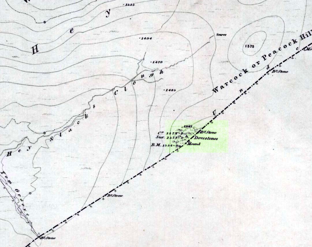
Takes a bitta finding and aint too accessible for those of you who need footpaths! Below the eastern slopes of Addlebrough Hill, by the present source of the Gill Beck right beneath the Dove Stones (the water tastes gorgeous), are the ruinous remains of an old sheepfold. In the field immediately behind (south) of here are a number of small rocks. Look around and you’ll find the stone in question!
Archaeology & History
Unless you’re a real rock-art-freak, I can’t imagine too many of you checking this one out! When Richard Stroud and I visited this spot a few years back (2006), it was a mixture of love and madness that brought us here!
Dove Stones Carving
Amidst the many stones scattered hereabouts, one of them possesses two clear cup-marks on a stone measuring roughly 3ft by 2ft, along the line of a much ruined ancient wall. This might be the one that Beckensall and Laurie (1998) described in their Prehistoric Rock Art of County Durham, Swaledale and Wensleydale, as “a rock with several cups (which) has recently been noticed on Thornton Rust Moor, near the Dovestones” — though it seemed blatantly apparent to us that there were only two cups here, not “several”. However, Brown (2008) appears to list the site, citing it as having “two cups”, just like the one we found, and being “found in prehistoric low field settlement wall,” which fits the picture perfectly — although Brown gives a slight difference in grid-reference to the one Richard Stroud took. It looks a good area to scout around and, I reckon, find previously unrecorded sites.
References:
Beckensall, Stan & Laurie, T., The Prehistoric Rock Art of County Durham, Swaledale and Wensleydale, County Durham Books 1998.
Brown, Paul & Barbara, Prehistoric Rock Art in the Northern Dales, Tempus: Stroud 2008.
Get to Widdop reservoir in the hills west of Hebden Bridge and park up. The great rock faces to your right (north) is where you’re going. Clamber to the top until the moor levels out, making sure you head NNW for less than a mile. The moors you’re now on are supposed to be private – but folk like me pay no attention! There are no footpaths to this great outcrop, only the heathlands and scattered stones – but keep walking for a half-mile north and you’ll get to them!
Archaeology & History
Erroneously ascribed by the place-name masters Eilert Ekwall and A.H. Smith (1961) as being ‘a place where doves gathered,’ this gigantic rock outcrop on the Yorkshire-Lancashire border — as shown on early maps — is actually the Dew or Black Stones (from the Gaelic, dubh). It’s an awesome place! Takes a bitta getting to, but it’s well worth the venture.
Dove Stones on 1848 map
This long geological ridge, rising higher as you walk along it to the north, has the occasional cup-mark on it, with the giant Dove Stone at the very end having a cup-and-half-ring on its crown (be careful not to fall off). From here, you look across a huge, desolate, U-shaped valley, the far side of which we rise to 1700 feet and the grand setting of the Lad Law.
Folklore
The folklorists Harland and Wilkinson (1882) included this in their survey of druidical sites, mentioning the several cup-markings, or druid basins as they called them. (though most of ’em on here are Nature’s handiwork)
For me, this is an incredible place – full of raw power and magick. It has a curious geomantic relationship with the Whinberry Stones, a couple of miles to the south, around which should be a ring of stones…though none can be found.
Nowadays marked on modern Ordnance Survey maps as part of a ‘Neolithic Sacred Complex,’ this linear monument was part and parcel of the Dorchester Big Rings henge complex and was associated with a number of other important prehistoric sites, many of which have been destroyed by ecological disfigurement projects in recent years. In Gordon Copley’s (1958) description of the monument, not long after its initial discovery, he said that this “was a cursus which consists of parallel ditches some 4000 feet long with 210 feet between them.” In more recent times Paul Devereux (1989) described how the cursus here,
“ran for three-quarters of a mile (1.2km) in a northwest to southeast direction on the north side of the Thames and was 210 feet (64 metres) wide. The cursus was part of a complex of crop marks, the most notable being” the henge. “The northwest end of the cursus remains unknown; the southeast end was rounded. The southeast segment…was on a slightly skew alignment compared to the rest of the feature, though it may have been the earliest part of the monument – bones found there were radio-carbon dated to around 3000 BC. The southern ditch of the cursus ran through and connected two earlier sites which shared a different alignment. Deposits of cremated bones, a stone arrowhead, fragments of pottery, a polished flint axe, and a circle of pits, probably the remains of a ‘woodhenge’ structure, were all found with the cursus.”
Dorchester cursus plan 1985
Jean Cook (1985) told that later excavations on the site in 1981, found that the shallow ditch which surrounded the entire cursus, “was interrupted by a central entrance on the southeast side. The southeastern terminal ditch respected a small prehistoric monument which has been dated to approximately 2000 BC.” This and other factors has led to the thought that the cursus may not all have been built at the same time. And indeed excavations at other sites scattering the northwestern ends of the cursus (shown in the plan here, Ed.) proved that a D-shaped enclosure “pre-dates the rest of the structure.” Other mortuary sites scattered the edges of the cursus that were added in the centuries which followed, but which need excavation work to uncover their secrets. Although much of this was done in the Atkinson digs, they were summarised well by Jean Cook (1985), who told:
“Site VIII, excavated in 1948, was a monument known as a mortuary enclosure. Sometimes such structures take the form of long barrows, but this one was a rectangular enclosure bounded on all four sides by a ditch with an internal bank. There were narrow entrance gaps on the two longer sides and a wider entrance in the centre of the shorter southern side. It is dated by the substantial sherds of Ebbsfleet ware (pottery) which were found in the upper filling of the ditch; part of a human jaw from within the enclosure helps to confirm the mortuary function.
“Site XI, excavated in 1949, consisted of three or more concentric ditches, of different dates, enclosing an incomplete ring of 14 pits. The middle ditch seems to have surrounded an oval barrow or enclosure and to have then been converted to a circular plan. Some of the pits contained animal bones, one contained an antler pick and one contained a complete human cremation, but there were no accompanying grave goods.
“Both these sites were in existence before the cursus was built. (my italics, Ed.) This is shown by the fact that the southernmost ditch of the cursus cuts through Site VIII and abuts Site XI. These two earlier sites seem to share the same alignment, but once the cursus was constructed it set a new alignment which may have been of significance until the end of the 3rd millenium BC. Three monuments built after the construction of the cursus were located inside it, two of them being along the central axis, and two others were just outside the southernmost ditch of the cursus but shared the same general alignment.
“Sites IV, V and VI, which were also excavated in 1949, have a similar overall plan and all of them contained a number of cremation deposits suggesting that amongst other things they acted as cemeteries. All three sites had a circular plan and consisted of an outer bank, to define the central area, and an inner ditch, the purpose of which seems to have been to provide earth for the bank. In Site IV the ditch was made up of eight oval pits, enclosing an area of about six metres in diameter. There was a broad entrance gap on the southeast side. Inside the enclosed area there were 25 deposits of cremated bones. An arrowhead was found with one of the cremations. Site V was very similar in construction, except that the entrance gap was on the northwestern side and contained 21 cremation deposits. No grave goods were found. Site VI again had a similar plan with the entrance gap to the north. There were 49 cremation deposits , one accompanied by a flint fabricator, an arrowhead and burnt flint flakes.
“Site 1 was excavated in 1946 and consisted of a small square ditch, enclosing another more or les circular ditch with an internal bank. Inside this ditch were 13 holes, forming a ring with an entrance gap on the western side. There were no entrances in the surrounding ditches. A crouched burial was found within the entrance to the ring of holes but there were no accompanying grave goods. Four cremations were found, two accompanied by fragmentary bone pins, in or besides four of the central holes. At a later stage in the neolithic period, parts of the ditch may have been enlarged to make temporary shelters: it is not clear to which period of use the cremations belong.
“Site II, also excavated in 1946, consisted of a causewayed (interrupted) ring ditch which was enlarged on two occasions. The third ditch had an internal bank in which were 19 cremation deposits. Two more cremations were found at the centre of the enclosed area. There was no evidence for any gap. Bone pins were found with four of the cremations as were flint fragments. In addition, antlers and other flint fragments were found, as well as pieces of pottery.
“In 1981 a small semi-circular enclosed ditch was excavated within the southeast terminal of the cursus. Though sited off-centre, the ditch shared the same alignment with the cursus. An antler (dated to c.2000 BC) was found close to the bottom of the ditch. After the ditch had virtually filled up with silt, the surviving low central mound was used for cremation deposits, one of them associated with a heavily burnt flint blade.”
Paul Devereux (1989) pointed out how one of the archaeologists studying this site found that if the axis of the monument was extended southeast, across the river, it lined up perfectly with another set of perfectly straight lines which were thought “likely to be a Roman trackway.” Unfortunately much of this area has been destroyed through the self-righteous ignorance of modern industrialism.
References:
Atkinson, R.J.C. et al, Excavations at Dorchester, Oxon, Department of Antiquities: Oxford 1951.
Barclay, A., Lambrick, G., Moore, J. & Robinson, M., Lines in the Landscape, OAU: Oxford 2003.
Cook, Jean, “The Earliest Evidence,” in Dorchester through the Ages, Oxford University 1985.
Cook, Jean & Rowley, Trevor (eds.), Dorchester through the Ages, Oxford University 1985.
Copley, Gordon J., An Archaeology of South-East England, Phoenix House: London 1958.
Loveday, Roy, Inscribed Across the Landscape, Tempus: Stroud 2006.
Pennick, Nigel & Devereux, Paul, Lines on the Landscape, Hale: London 1989.
Easy one this! Go up thru Baildon, on towards Baildon Moor over the cattle-grid. Take your first left and go up for several hundred yards past the reservoir until you reach the track on the left which takes you onto the Low Plain, Baildon Moor.
Archaeology & History
1845 plan of Cairns & Earthworks on Baildon Moor (after J.N.M. Colls)
In the year 1845, on the Low Plain on the western side of Baildon Hill, an intrepid archaeologist and historian, Mr. J.N.M. Colls, came across extensive earthworks and a number of prehistoric tombs in a very small area. Upon excavation, the ‘earthworks’ were found to be what sounds like neolithic walling running parallel to each other in a roughly north-south direction (north is the traditional direction for death). Scattered amidst these lines he found more than a dozen cairns and barrows, along with remains of “a circle, or ring.” Although the majority of what Colls wrote about has been destroyed, leaving only scanty remains of a once considerable archaeological arena, his lengthy description deserves being reprinted in full. He wrote:
“This level (the Low Plain) bears numerous traces of earthworks or other embankments running in many cases parallel with one another, at distances varying from 50 to 80 yards apart, and intersected by other works of similar construction. These earthworks can be remembered to have been from four to five feet in height; their bases nearly invariably appear to have been eight feet in diameter, composed of loose blocks of calliard, or close-grained sandstone, and earth. The greater part of the stone has been torn away to make and repair the roads of the neighbouring district; and the surface of the earth has been so nearly levelled that it is only by the scattered and disfigured remains, carefully delineated upon my plan, that any idea can be formed of their original character.
“In connection with these earthworks, and upon the north side of them, immediately above a steep fall to the next lower level (approx SE 1372 4020, Ed.), is a circle, or ring, formed originally of earthworks of precisely similar character, size and construction to those I have just described. The diameter of this ring is about fifty feet; its interior area is perfectly level; but the earthwork forming its circumference has been defaced and torn up for a considerable extent for the stone it contained. Circles of this nature have generally been termed druidical, from their presumed use as places of worship or sacrifice. I therefore opened its centre, in the hope of finding some trace of fire confirmatory of its character; and commenced clearing away a layer of peat earth, of from 10-11 inches in depth. I then found a layer of calliard boulders one-and-a-half feet in depth, the lower ones slightly burned, and resting upon a deposit of peat-ashes three inches in depth and from 2-3 feet in diameter (see Barrow No.8 in plan, Ed.). This I should have concluded to be the remains of a beacon fire, but, upon continuing the excavations, I found about three feet SSE of this deposit of ashes (at point b on the plan) a rude urn standing in an upright position, at a depth of two feet from the surface, a layer of calliard stones having been removed from above it, one of which appeared to have covered it. This urn was 12 inches in diameter and 9-10 inches in depth, of a circular or bowl shape, the upper stage of it being rudely ornamented by incised lines crossing each other at acute angles: it was filled with calcined bones (some remaining tolerably perfect), ashes and charcoal; and I selected some half-dozen of them as specimens, which Mr Keyworth, surgeon and lecturer on anatomy at York, has examined… He is of the opinion that they belonged to a very young subject, perhaps from 9-12 or 13 years of age; he thinks it possible however, that they may all have belonged to the same subject… The urn in which the were placed appears to have been rudely formed by the hand, without the assistance of a lathe; in substance about half-an-inch…it appears pretty evident that this urn has been formed of the black earth of the mountain and coal measures of which Baildon Hill is formed…
“A little to the west by south of the circle…are the almost obliterated remains of another circle (fig.9 on the plan), which I had not an opportunity of thoroughly examining; the slight traces remaining bear strong testimony of its character being similar to that of fig.8.
“Scattered over the surface of the Plain, and at irregular distances, cairns or heaps of stones, composed of bare sandstone and calliards (and not mixed with earth), frequently occur; they are generally about twenty feet in diameter and appear to have been originally 4 or 5 feet in height: these remains still require examination. In passing over them, I remarked that some of the stones of which they and the earthworks near them were constructed, had marks, or characters, but so rude that a doubt remains whether they may not have been caused by the action of the atmosphere on the softer portions of the stone.”
Urns found near Dobrudden
This final remark seems to be the very first written intimation of the cup-and-ring marked stones which can still be found amidst the grasses in the very area Mr Colls described. Sadly, much of the other remains shown in the drawing have been all but obliterated, or grown over. However, the decent concentration of cup-and-ring stones in this small area (see other Baildon Moor entries), highlights once again an associated prevalence of these carvings with our ancestor’s notions of death.
Sadly, year by year, the important neolithic and Bronze Age english heritage remains across this upland ridge are slowly being destroyed. The lack of attention and concern by regional archaeologists and local councillors, and the gradual encroachment of human erosion are the primary causative factors. Hopefully there are some sincere archaeologists in the West Yorkshire region who will have the strength to correctly address this issue. Under previous archaeological administrators, Bradford Council have allowed for the complete destruction of giant tombs, stone circles and other important prehistoric remains in their region—a habit that seems not to be curtailed as they maintain a program of footpath “improvements” on local moors without any hands-on assessment of the archaeology on the ground.
…to be continued…
References:
Baildon, W. Paley, Baildon and the Baildons – volume 1, St. Catherine Press: Adelphi 1913.
Barnes, Bernard, Man and the Changing Landscape, Eaton Press: Wallasey 1982.
Colls, J.N.M., ‘Letter upon some Early Remains Discovered in Yorkshire,’ in Archaeologia, volume 31, 1846.
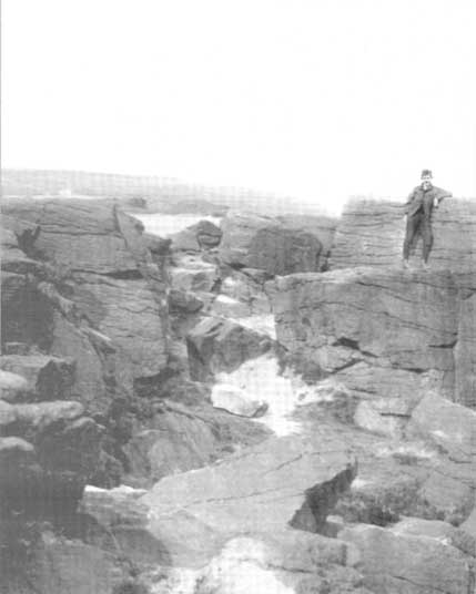
This is a stupendous site! It looks like some of this may have been quarried, a long time ago, but it also seems that nothing at all has been written about it – even in the simple travelogues beloved by our Victorian historians. To come across it quite by accident, as I did (only yesterday), was excellent! When I first got here, by following the wooded ridge betwixt Hollins Lane and the main Keighley-to-Steeton road (A629), the place seemed brilliant; but as time went on and my amblings through the sometimes dense and also very old woodland were overcome by the dream of the place, I couldn’t believe how this place had become forgotten. Adrenalin rushed through me for a while, but then it was the dream of the place again. The memories here were ancient – and you could feel them. In places there was the solace of darkness, beloved of those who know old trees and dangerous places. For here, walk the wrong place too quickly and Death comes. Broken limbs await in the curious gorges which just appear in the woods, only a yard wide, but 50-60 foot deep, only to vanish again away from sight a few yards later. Caves and dark recesses, seemingly unknown, reach out to climb down. And all round is the aged covering of lichens and mosses that know centuries.
Shown as ‘Garlic Kirk’ on 1853 map
The Kirk itself – meaning simply, ‘place of worship’, in the old sense – is like something out of Lord of the Rings! If you walk along its top, as I did, the great cliffs below come late to the senses. A curious ridge of cup-markings, seemingly natural ones, stretch along the very edges of the drop – which stretches on for some distance. And then as you walk along its edge, you find this great drop which looks north, is now on both sides of your feet! It’s quite breathtaking!
Cup-markings on the edge (probably natural)
Trying to get down into the gorge below can be done, but it’s a bit dodgy! If you aint agile and crazy, stick to doing it by walking round – a long way round… Someone a few centuries back either cut into the rock, or laid steps, reaching into the mossy gorge, which runs to nowhere.
You can appreciate how this place would have been a sacred site: it’s big, it’s old, it takes your breath away, and it looks across to the great Rivock Edge where many fine cup-and-ring stones were cut. I’ll try and get some images of the place when I call here again in the very near future, but they’ll never capture the experience of being here.
Folklore
The only thing I have come across which seemingly relates to this great edifice, tells of a great cave in the woodland, which legend tells stretches many miles to the north and emerges at Bolton Abbey. (Clough 1886) I wondered about the potential visibility factor in this legend and found it obviously didn’t work. However, if you stand on a certain part of The Kirk and look north, a dip in the horizon enables us to see, far away, hills which rise up directly above the swastika-clad Bolton Abbey. Twouldst be good to work out exactly which hill above the Abbey we can see from here.
On another issue, John Clough (1886) told that “on top of the rock there is a footprint and the initials of one of the Waites, who is said to have leaped over the chasm.”
References:
Clough, John, History of Steeton, S. Billows: Keighley 1886.
Gray, Johnnie, Through Airedale from Goole to Malham, Walker & Laycock: Leeds 1891.
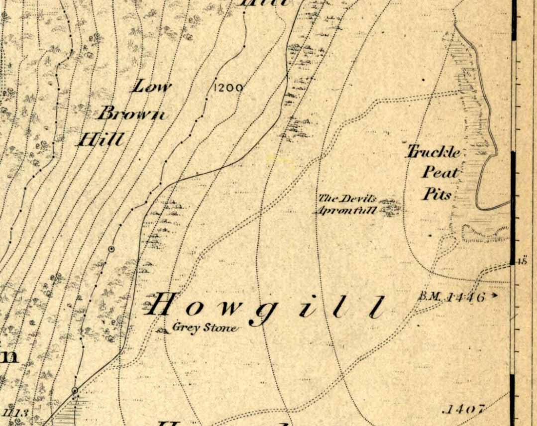
An excellent spot with fantastic views. There’s many ways to approach the place, but a good one is from the roadside by Howgill, then following the track uphill until you reach the moor, then head towards the spectacular and legendary, Simon’s Seat (which folklore ascribes to be named after the great druid, Simon Magus). You’ll pass an old Grey Stone (two large rocks) from which you can espy the old tomb if you stand on top of ’em. Keep walking uphill and it’s about 100 yards off the footpath to your right. A large boulder is nestled just beneath the tomb itself, which stands out on a ridge.
Archaeology & History
When Harry Speight visited here (1900) he described it as being 40 yards in circumference. He also described “an upright stone below the cairn” with apparent cup-markings on the west-side. I’m not quite sure where this has got to – but the site has shrunk somewhat since Speight’s day. It’s only about 20 feet across now, and the middle of it has been hollowed into a grouse-shooting butt for the toffs!
About 100 yards southeast (towards the Truckle Stones) are the remains of some neolithic walling in a straight line.
Folklore
One of many old tombs in our northern hills said to have been created by the devil who, as usual, accidentally dropped some stones he was carrying. The old folklorist Thomas Parkinson (1888) said the following of this place:
“The Apronful of Stones is a group of rocks heaped together in delightful confusion, their disorder and name being thus explained: Once upon a time—whether when he built the bridge over the valley, or at some other time, the record saith not—the Devil was determined to fill up the ravine, or gill, of the Dibble. For this purpose he was carrying these enormous crags in his apron, when, too intent upon his object to properly observe where he placed his feet, he caught with one foot upon the top of Nursa Knott, and, stumbling, the strings of the apron broke, and the contents were thrown upon the ground as they now appear. It is also said of them that if any of them, even now, were to be removed, they would certainly be brought back to their original place during the succeeding night.”
Another legend tells that the Devil’s Apronful is also the grave of some local unnamed hero.
References:
Parkinson, Thomas, Yorkshire Legends and Traditions – volume 1, Elliott Stock: London 1888.
Speight, Harry, Upper Wharfedale, Elliott Stock: London 1900.
Take the A816 south from Oban and after 2 miles at the hamlet of Kilmore, turn left. Follow the road for nearly a mile and as the loch appears ahead of you, stop! The small island crannog is close by the bottom of the loch in front of you.
Archaeology & History
Curiously omitted from the Scottish Royal Commission inventory for Lorn (1974), when R. Angus Smith and his friends explored this artificial island in the 1860s and ’70s, he told:
“it is nearly round, not much larger than a good-sized cottage. It is surrounded by stones large enough to be difficult to lift, and in some places showing themselves to have been put together by art. It would appear as if there had been a pretty firm wall all round – very firm it could not be without mortar or heavier stones. Three or four feet within the range of stones is a raised turf-mound, as if this had been the wall of a house; the centre of the space was rather higher than the rest, and there we expected a fire-place to be found.”
Once they’d got onto the old crannog, Smith and his associates started digging, saying,
“by digging about three feet and a half, the ashes of peat were obtained, bones, charcoal and nuts. A very small hole was made, as we had not then received liberty to dig. We were satisfied that this had been a lake-dwelling, and that it had been defended by a wall. Advantage seems to have been taken of a shallow place, and stones must have been carried to it. It may turn out that there is a wooden foundation. It is not easy to see by what means the covering of earth now over the floor was so much raised. The water of the lake forms little or no deposit in summer; art rather than natural circumstances may have raised the soil. The bones here were split, as at the lake-dwelling in the moss.”
References:
Smith, R. Angus, Loch Etive and the Sons of Uisneach, Alexander Gardner: London 1885.


")