Fairy Stone, Cottingley, Bingley, West Yorkshire

Cup-and-Ring Stone:  OS Grid Reference – SE 09816 37862

Also Known as: 

  1. Black Hills Carving 01
  2. Cottingley Woods (01) carving

Getting Here

To get here, start from Bingley centre, go through Myrtle Park, across the river bridge and turn right at the dirt-track. Walk on & go over the old bridge/ford of Harden Beck, keeping with the track until the next set of buildings and be aware of a footpath left here. Take this and cross the golf-course, bearing SE until you reach the edge of Cottingley Woods. Take the distinct footpath into the trees & walk up the vivid moss-coloured path until you reach the level at the top where the woods become more deciduous. Here, turn left for 100 yards into the bit of woodland which has been fenced-off and walk about. You’ll find it!

Archaeology & History

Cottingley Woods Fairy Stone

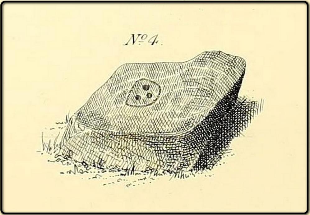
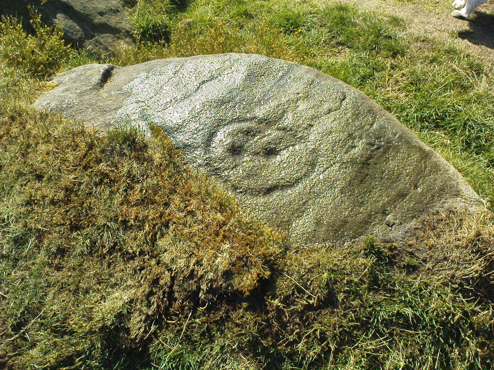
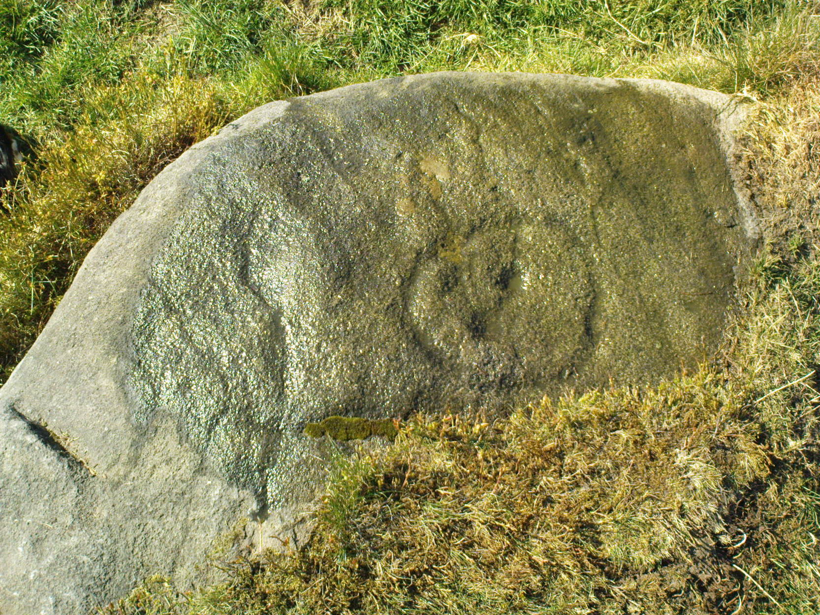
This is a truly superb cup-and-ring stone which anyone into the subject must take a look at!  It was first found by the old forester here, Ronald Bennett, in 1966 — ten years before the rock art student Keith Boughey (2005) mistakenly reported it to have been found “by Valerie Parkinson…in 1976.”  Everything about it’s excellent — but I think the setting in woodland is what really brings it out.

The first published account and photograph of this superb carved stone seems to have been in Joe Cooper’s (1982) precursory essay on the Cottingley Fairies in an article he wrote for The Unexplained magazine in the 1980s.  A few years later I included the stone in a short article on local folklore (Bennett 1988), then again much later in The Old Stones of Elmet (2001).  It was curiously omitted from Boughey & Vickerman’s (2003) survey, as were the other carvings that are found very close by.  Not sure why…  But of the small cluster here (I’ll add the others later), this carving stands out as the best of the bunch by far!  Its name has nothing to do with the Cottingley Fairy folk down town: it simply originates from my own teenage thoughts and the true ambience of the setting. Check it out!

Joe Cooper’s 1982 photo
Fairy Stone carving

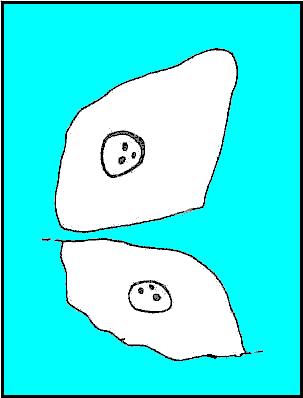
The rock is typical millstone grit and its carved upper surface measures roughly 3 yards east-west and 2 yards north-south, sloping gently into the ground.  As the photo shows, this is an elaborate design seemingly centred around two large and another smaller circular form, each enclosing a number of internal cups, ring and lines.  The next time we’re over there, we’ll try get some clearly images and make a detailed drawing of the old fella!  In the event that you visit here, check out the other three carvings close to this primary design — and try work out which one of the three was carved by the scouts in more modern times!  Another simple cup-marked stone was recently found in the undergrowth a short distant east of this group.

Sketch of the design in 1981

Recently the carving was given attention with what’s known as photogrammetry software: this enables a more complete image of the 3-dimensional nature of objects scrutinized.  In the resulting photos (which I’m unable to reproduce here due to copyright restrictions), a previously unseen long carved line was detected that runs across the middle of the larger of the two enclosing rings.  Hopefully in the coming months, those with the software (can’t remember whether it’s English Heritage or Pennine Prospects who won’t allow it) might allow us to reproduce one or two of their images to enable the rest of the world to see what their images have uncovered.  After all, considering that we peasants brought this carving to their attention, you’d at least hope they could repay the finds.  Some of these larger organizations, despite what they may say, simply don’t swing both ways!

Folklore

In an early edition of my old Fortean archaeology rag of the 1980s, I narrated the tale of one Anne Freeman, who was walking through the woods here.  When she reached the top of the woods, near some stones she heard a loud chattering and allegedly saw two tiny figures barely one-foot tall wearing red outfits and green hats in “medieval peasant dress”.  Andy Roberts (1992) later repeated the tale and illustrated the carving in his Yorkshire folklore work.

In the 1960s, the old ranger Ronnie Bennett (no relative of mine) who first found these carvings, also reported that he saw little people here: “not one, but three,” as he said.  Not fairies with wings, but more gnome-like.

References:

  1. Bennett, Paul, Of Cups and Rings and Things, unpublished: Shipley 1981.
  2. Bennett, Paul, ‘Tales of Yorkshire Faeries,’ in Earth 9, 1988.
  3. Bennett, Paul, The Old Stones of Elmet, Capall Bann: Milverton 2001.
  4. Boughey, Keith, “A Group of Four Cup-and-Ring-Marked Rocks at Black Hills, Cottingley Woods,” in Prehistory Research Section Bulletin, no.42, 2005.
  5. Cooper, Joe, ‘Cottingley: At Last the Truth,’ in The Unexplained 117, 1982
  6. Roberts, Andy, Ghosts and Legends of Yorkshire, Jarrold 1992.

© Paul Bennett, The Northern Antiquarian

Druid’s Altar, Bingley, West Yorkshire

Legendary Rocks: OS Grid Reference – SE 0924 3994

Getting There

Druid’s Altar, sitting with mist

Pretty easy to get to. Best thing to do really, is ask a local and they’ll send you in the right direction. From Bingley, take the Harden road (B6429) across the river. As it bends sharply left, note there’s a track going up into the woods to the right. Walk up it! Keep going and, unless you take a detour, you’ll end up at the rock outcrop eventually (where the woods come to an end, Druid’s Altar appears before you with the track running along its top-side).

Archaeology & History

Mentioned in the Tithe Awards of 1849, this lovely outcrop of rocks looking down the Aire Valley on the southern edge of Bingley has “an immemorial tradition” of druidic worship, said Harry Speight in 1898 – though quite when it first acquired such repute is outside of any literary record.  In Sidney Greenbank’s (1929) rare book on this place, he could find little by way of archaeological data to affirm the old tradition, save the odd prehistoric find of flints here and there; though it is said that Beltane fires were burned upon the crags here in bygone centuries.

1894 photo of Druid's Altar (courtesy Clive Hardy)
1894 photo of Druid’s Altar (courtesy Clive Hardy)

There was a 19th century account from the Ilkley Scientific Club where a member described there being a cup-and-ring carving “near the so-called Druid’s Altar, at Bingley,” but I’m unaware of the whereabouts of this carving and Boughey & Vickerman’s (2003) said nothing about it in their survey; though a possible cup-marking can be seen on one rock less than 100 yards west, which might account for the report. (a bit dodgy though!)

Folklore

Harry Speight (1898) makes what sounds like a rare flight of fancy when he described faerie being seen atop of the many oaks beneath the Druid’s Altar.  In Clive Hardy’s (2002) work (from whence the old photo of the Altar is taken), he tells how “local antiquarians say that the cobbled way running from the Brown Cow Inn towards the site, is an old processional route walked by the druids.”

One, possibly two wells, each beneath the Altar rocks, are also reputed to have been associated with the old pagan priests, as their names tell: the Altar Well and the Druid’s Well – though the Altar Well has seemingly fallen back to Earth in recent years.

References:

  1. Greenbank, Sidney, The Druid’s Altar, Bingley, R.G. Preston: Bingley 1929.
  2. Hardy, Clive, Around Bradford, Frith Book Ltd: Salisbury 2002.
  3. Moores, Les, Ancient Monuments and Stone Circles, Francis Frith Collection: Salisbury 2005.
  4. Speight, Harry, Chronicles and Stories of Bingley and District, Elliott Stock: London 1898.
  5. Turner, J. Horsfall, Ancient Bingley, Thomas Harrison: Bingley 1897.

© Paul Bennett, The Northern Antiquarian


Dobrudden Necropolis, Baildon Moor, West Yorkshire

Cairns:  OS Grid Reference – SE 138 402

Getting Here

Easy one this!  Go up thru Baildon, on towards Baildon Moor over the cattle-grid.  Take your first left and go up for several hundred yards past the reservoir until you reach the track on the left which takes you onto the Low Plain, Baildon Moor.

Archaeology & History

1845 plan of Cairns & Earthworks on Baildon Moor (after J.N.M. Colls)

In the year 1845, on the Low Plain on the western side of Baildon Hill, an intrepid archaeologist and historian, Mr. J.N.M. Colls, came across extensive earthworks and a number of prehistoric tombs in a very small area. Upon excavation, the ‘earthworks’ were found to be what sounds like neolithic walling running parallel to each other in a roughly north-south direction (north is the traditional direction for death).  Scattered amidst these lines he found more than a dozen cairns and barrows, along with remains of “a circle, or ring.”  Although the majority of what Colls wrote about has been destroyed, leaving only scanty remains of a once considerable archaeological arena, his lengthy description deserves being reprinted in full.  He wrote:

“This level (the Low Plain) bears numerous traces of earthworks or other embankments running in many cases parallel with one another, at distances varying from 50 to 80 yards apart, and intersected by other works of similar construction.  These earthworks can be remembered to have been from four to five feet in height; their bases nearly invariably appear to have been eight feet in diameter, composed of loose blocks of calliard, or close-grained sandstone, and earth.  The greater part of the stone has been torn away to make and repair the roads of the neighbouring district; and the surface of the earth has been so nearly levelled that it is only by the scattered and disfigured remains, carefully delineated upon my plan, that any idea can be formed of their original character.

“In connection with these earthworks, and upon the north side of them, immediately above a steep fall to the next lower level (approx SE 1372 4020, Ed.), is a circle, or ring, formed originally of earthworks of precisely similar character, size and construction to those I have just described.  The diameter of this ring is about fifty feet; its interior area is perfectly level; but the earthwork forming its circumference has been defaced and torn up for a considerable extent for the stone it contained.  Circles of this nature have generally been termed druidical, from their presumed use as places of worship or sacrifice.  I therefore opened its centre, in the hope of finding some trace of fire confirmatory of its character; and commenced clearing away a layer of peat earth, of from 10-11 inches in depth.  I then found a layer of calliard boulders one-and-a-half feet in depth, the lower ones slightly burned, and resting upon a deposit of peat-ashes three inches in depth and from 2-3 feet in diameter (see Barrow No.8 in plan, Ed.).  This I should have concluded to be the remains of a beacon fire, but, upon continuing the excavations, I found about three feet SSE of this deposit of ashes (at point b on the plan) a rude urn standing in an upright position, at a depth of two feet from the surface, a layer of calliard stones having been removed from above it, one of which appeared to have covered it.  This urn was 12 inches in diameter and 9-10 inches in depth, of a circular or bowl shape, the upper stage of it being rudely ornamented by incised lines crossing each other at acute angles: it was filled with calcined bones (some remaining tolerably perfect), ashes and charcoal; and I selected some half-dozen of them as specimens, which Mr Keyworth, surgeon and lecturer on anatomy at York, has examined… He is of the opinion that they belonged to a very young subject, perhaps from 9-12 or 13 years of age; he thinks it possible however, that they may all have belonged to the same subject… The urn in which the were placed appears to have been rudely formed by the hand, without the assistance of a lathe; in substance about half-an-inch…it appears pretty evident that this urn has been formed of the black earth of the mountain and coal measures of which Baildon Hill is formed…

“A little to the west by south of the circle…are the almost obliterated remains of another circle (fig.9 on the plan), which I had not an opportunity of thoroughly examining; the slight traces remaining bear strong testimony of its character being similar to that of fig.8.

“Scattered over the surface of the Plain, and at irregular distances, cairns or heaps of stones, composed of bare sandstone and calliards (and not mixed with earth), frequently occur; they are generally about twenty feet in diameter and appear to have been originally 4 or 5 feet in height: these remains still require examination.  In passing over them, I remarked that some of the stones of which they and the earthworks near them were constructed, had marks, or characters, but so rude that a doubt remains whether they may not have been caused by the action of the atmosphere on the softer portions of the stone.”

Urns found near Dobrudden

This final remark seems to be the very first written intimation of the cup-and-ring marked stones which can still be found amidst the grasses in the very area Mr Colls described.  Sadly, much of the other remains shown in the drawing have been all but obliterated, or grown over.  However, the decent concentration of cup-and-ring stones in this small area (see other Baildon Moor entries), highlights once again an associated prevalence of these carvings with our ancestor’s notions of death.

Sadly, year by year, the important neolithic and Bronze Age english heritage remains across this upland ridge are slowly being destroyed.  The lack of attention and concern by regional archaeologists and local councillors, and the gradual encroachment of human erosion are the primary causative factors.  Hopefully there are some sincere archaeologists in the West Yorkshire region who will have the strength to correctly address this issue. Under previous archaeological administrators, Bradford Council have allowed for the complete destruction of giant tombs, stone circles and other important prehistoric remains in their region—a habit that seems not to be curtailed as they maintain a program of footpath “improvements” on local moors without any hands-on assessment of the archaeology on the ground.

…to be continued…

References:

  1. Baildon, W. Paley, Baildon and the Baildons – volume 1, St. Catherine Press: Adelphi 1913.
  2. Barnes, Bernard, Man and the Changing Landscape, Eaton Press: Wallasey 1982.
  3. Colls, J.N.M., ‘Letter upon some Early Remains Discovered in Yorkshire,’  in Archaeologia, volume 31, 1846.

© Paul Bennett, The Northern Antiquarian


The Kirk, Steeton, West Yorkshire

Legendary Rocks:  OS Grid Reference – SE 0418 4391

Also known as:

  1. Garlic Kirk

The Kirk, Hawkcliffe Woods, Steeton

This is a stupendous site!  It looks like some of this may have been quarried, a long time ago, but it also seems that nothing at all has been written about it – even in the simple travelogues beloved by our Victorian historians.  To come across it quite by accident, as I did (only yesterday), was excellent!  When I first got here, by following the wooded ridge betwixt Hollins Lane and the main Keighley-to-Steeton road (A629), the place seemed brilliant; but as time went on and my amblings through the sometimes dense and also very old woodland were overcome by the dream of the place, I couldn’t believe how this place had become forgotten.  Adrenalin rushed through me for a while, but then it was the dream of the place again.  The memories here were ancient – and you could feel them.  In places there was the solace of darkness, beloved of those who know old trees and dangerous places.  For here, walk the wrong place too quickly and Death comes.  Broken limbs await in the curious gorges which just appear in the woods, only a yard wide, but 50-60 foot deep, only to vanish again away from sight a few yards later.  Caves and dark recesses, seemingly unknown, reach out to climb down.  And all round is the aged covering of lichens and mosses that know centuries.

Shown as 'Garlic Kirk' on 1853 map
Shown as ‘Garlic Kirk’ on 1853 map

The Kirk itself – meaning simply, ‘place of worship’, in the old sense – is like something out of Lord of the Rings!  If you walk along its top, as I did, the great cliffs below come late to the senses.  A curious ridge of cup-markings, seemingly natural ones, stretch along the very edges of the drop – which stretches on for some distance.  And then as you walk along its edge, you find this great drop which looks north, is now on both sides of your feet!  It’s quite breathtaking!

Cup-markings on the edge (probably natural)

Trying to get down into the gorge below can be done, but it’s a bit dodgy!  If you aint agile and crazy, stick to doing it by walking round – a long way round…  Someone a few centuries back either cut into the rock, or laid steps, reaching into the mossy gorge, which runs to nowhere.

You can appreciate how this place would have been a sacred site:  it’s big, it’s old, it takes your breath away, and it looks across to the great Rivock Edge where many fine cup-and-ring stones were cut.  I’ll try and get some images of the place when I call here again in the very near future, but they’ll never capture the experience of being here.

Folklore

The only thing I have come across which seemingly relates to this great edifice, tells of a great cave in the woodland, which legend tells stretches many miles to the north and emerges at Bolton Abbey. (Clough 1886)  I wondered about the potential visibility factor in this legend and found it obviously didn’t work.  However, if you stand on a certain part of The Kirk and look north, a dip in the horizon enables us to see, far away, hills which rise up directly above the swastika-clad Bolton Abbey.  Twouldst be good to work out exactly which hill above the Abbey we can see from here.

On another issue, John Clough (1886) told that “on top of the rock there is a footprint and the initials of one of the Waites, who is said to have leaped over the chasm.”

References:

  1. Clough, John, History of Steeton, S. Billows: Keighley 1886.
  2. Gray, Johnnie, Through Airedale from Goole to Malham, Walker & Laycock: Leeds 1891.

© Paul Bennett, The Northern Antiquarian


Yoni Stone, Utley, Keighley, West Yorkshire

Standing Stone:  OS grid reference – SE 0390 4333

Also known as:

  1. Cunt Stone

Getting Here

From Keighley town centre, head north towards Cliffe Castle, but turn left beforehand and along Hollins Lane.  Go past Hollins Hall for a few hundred yards and then through the gate on your left, then straight up the steep hill to the small woodland at the top.  On the OS-map it’s shown as ‘Great Snowden.’  You’re here!

Archaeology & History

A standing stone found recently by Lindsay Lockwood to the west of Keighley, albeit on supposedly private—ahem!—land (a number of old locals tell you, quite rightly, to ignore this selfishness; but be careful of the land-owners here, who can be quite miserable).  Tis less than four-feet tall but with a very noticeable female genital carving on its top western face.  This carving however, is perhaps 200 years old at the very most.  It’s in a quite beautiful setting aswell…

The Yoni or Cunt Stone, Utley
Buddhist scholar Steve Hart fondling the stone

What may be the remains of an old hut circle, or an old  drained-out pond (a big difference, I know!), can be found about 100 yards northwest, and one – possibly two – ‘cairns’ can also be found in the scattered trees immediately to the northeast. An old ‘druid’s bowl’ (natural cup-marking into which rain-water collects) can also be seen on an adjacent earthfast boulder.  Some folk might wanna allege a bullaun, but it’d be pushing it a bit I think. More recent walling and what appears to be stonework from more recent centuries (medieval) appears evident close by.  Whilst below the hill we have the recently discovered Dragon Stone cup-and-ring carving just a few hundred yards away.

The setting is not unlike the beautiful little standing stone of Tirai on the slopes of Glen Lochay, where amidst the recently deserted village the short squat standing stone is found. You get the same sorta feeling of more recent going-on with this site aswell.

The carved ‘cunt’ gives an even more intriguing thought as to what the stone was used for, around Beltane perhaps, by folk like misself and other straightforward doods!

I wasn’t sure exactly what to call the stone after Lindsay had found it.  However, due to the carved minge near the top, it seemed right to give the stone a name relative to the carving — and as we have a Devil’s Cunt in the Netherlands, I opted to call it something similar.*  Although ‘cunt’ is an old European word for ladies’ lovely parts, the word ‘Yoni’ is an eastern title, which has become very acceptable in Western parlance.  In recent years there has emerged a distinct aversion to using our own, old word for female genitals (indicating how detached people have become from even their own roots).

* of the name ‘cunt stone’: the word cunt itself, as explored eloquently in the fine study by Peter Fryer, Mrs Grundy: Studies in English Prudery (Corgi: London 1965), was the acceptable term for ladies’ genitals in the days when this carving was evidently done, so thought it a most applicable title.

© Paul Bennett, The Northern Antiquarian 


Crosley Wood, Gilstead, Bingley, West Yorkshire

Enclosure / Settlement:  OS Grid Reference – SE 1186 3859

Getting Here

Along the main Aire Valley road (A650) between Cottingley and Bingley, turn right by Beckfoot Grammar School and wander along and up the winding road, over the canal bridge where the Fisherman’s pub is on Primrose Lane.  On the slope above you amidst the scatter of trees on the left-hand side of the road is this Romano-British site (the map below should help).  Check it out!

Archaeology & History

Excavated in the 1960s by the archaeologist P. Mayes, this little-known but reasonably well-preserved enclosure-cum-settlement comprises of a large oval of stone walling, double in places, about 200 feet across at its widest point.

Crosley Wood ground plan (YAJ 42, 1967)
Crosley Woods map (YAJ 42, 1967)

Thought to have been constructed sometime between the Iron Age and Romano-British period, for some reason one of the stones on the western edge has long been given the name of the ‘Giles Stone’ or Stile — though nobody knows for certain why.  It’s about three-feet tall with a smaller upright by its side.  Any other remains that might once have been here were destroyed by the housing estate that sits above here.  When Mr Mayes (1967) and his associates did their work here, cutting across sections of the walling, he told:

“The best preserved section of wall was amongst the trees on the lines of the south wall of the enclosure and included the boulders of both the inner and the outer faces of the wall.  A trench 6ft by 38ft was laid out at right angles to it.  The turf was removed showing the boulders of the wall with the smaller stone filling between them.  On either side of the wall was a relatively small quantity of loosely tumbled stones, the angle of rest of which suggested the wall as their source of origin… Careful examination of the wall filling failed to show any sign of post settings.”

Mr Mayes said that it was “doubtful whether the Crosley Wood site, dated by one pot to the late 3rd or early 4th century AD, was ever conceived of as an occupation site.”  In reference to his excavations he continued, “Certainly no evidence of settled living was found” here, concluding:

“It seems probable that the main enclosure at Crosley Wood served as a cattle pound; its defensive potential being invalidated by the scarp to the north, whilst the short stretches of external walling are all that remains of a rectilinear field system for arable or pastoral farming.”

References:

  1. Mayes, P., ‘Excavations at Crosley Wood, Bingley,’ in Yorkshire Archaeology Journal, volume 42, 1967.

© Paul Bennett, The Northern Antiquarian


Calverley Woods (12), Leeds, West Yorkshire

Cup-Marked Stone:  OS Grid Reference – SE 2006 3790

Also Known as

  1. Carving no.12 (Boughey & Vickerman)

Getting Here

Lost Cup-Marked Stone, Calverley Woods

Troublesome really, as it’s got lost somewhere amidst the undergrowth.  From the valley bottom at Apperley Bridge, take the road-then-track which goes up thru the Calverley Cutting (as locals call it), turning left along the dirt-track just as the track begins to slope uphill.  Go past the detached house in the edge of the trees and shortly past there is a small footpath taking you into the trees on your left,  Walk down and along here, near the bottom of the tree-line above the walling.  If you find it, let us know!

Archaeology & History

Included in Boughey & Vickerman’s (2003) survey as ‘stone 12’ – it was first described by Sidney Jackson in 1954, who later gave us a map and drawing of the stone.  I looked for it several times x-number of years back, but never found it (though was led astray a little by the profusion of Amanitas in the locale!).  Comprising at least 18 cup-markings on a generally flat rock surface, to this day the carving remains unfound, though is probably under the herbage hereabouts.  The same fate seems to have befallen the West Woods 1 and West Woods 2 carvings in another part of the same woods.  Does anyone know what’s become of them?

References:

  1. Bennett, Paul, “The Undiscovered Old Stones of Calverley Woods,” in Earth no.2, 1986.
  2. Boughey, Keith & Vickerman, E.A., Prehistoric Rock Art of the West Riding, West Yorkshire Archaeology Service 2003.
  3. Jackson, Sidney (ed.), ‘Calverley Wood Cup-Marked Rock,’ in Bradford Cartwright Hall Archaeology Group Bulletin, 1:1, 1954.
  4. Jackson, Sidney (ed.), ‘Cup-Marked Boulder in Calverley Wood,’ in Bradford Cartwright Hall Archaeology Group Bulletin, 1:7, 1955.
  5. Jackson, Sidney (ed.), ‘Cup-and-Ring Boulders near Calverley,’ in Bradford Cartwright Hall Archaeology Group Bulletin, 1:16, 1956.

© Paul Bennett, The Northern Antiquarian 


Brackenhall Circle, Baildon Moor, West Yorkshire

Enclosure:  OS Grid Reference – SE 1305 3908

Also Known as:

  1. Brackenhall Ring
  2. Catstones Ring
  3. Soldier’s Trench

Getting Here

To get here, ask all and sundry where Shipley Glen is and, once there, head to the Brackenhall Countryside Centre. It’s less than 100 yards past it, right on the roadside (a coupla nice birches sit in its edge).

Archaeology & History

Lay-out of the Catstone's Ring (North is an approximation)
Lay-out of Catstone’s Ring

Described by many local writers over the years and marked on modern OS-maps as ‘The Soldier’s Trench,’ this curious double-ring of stones has long been somewhat of an archaeological anomaly.  The archaeologist John Barnatt thought it to be “almost certainly an enclosure, of indeterminate age”; and similarly so by Faull and Moorhouse (1981), who described it as a settlement or enclosure.  It has previously been classified as a ‘stone circle’ by archaeologists, and although I’ve added it to the listing of such sites here on TNA, I do so as a historical tradition, as the site aint a true megalithic ring.  Although we don’t know exactly what it was used for, we’re better using the term ‘enclosure’ for it.

The first description of the place was by J.N.M. Colls (1846).  When the pseudonymous Johnnie Gray (a.k.a. Harry Speight) got here he wrote:

“It comprises portion of an earthwork (which was perfect a few years ago), raised between two concentric circles, whose grater circumference is 137 yards, and diameter 57 yards north to south, and 39 yards east to west… There are unmistakable evidences about it of immense fires.”

Earliest known image (Glossop 1882)

At least two of the stones in this double-ringed complex have cup-markings etched on them; though Boughey and Vickerman (2003) report a third such carving, but doubt its authenticity.  They may be right.

Folklore

The other name for this site, the Soldier’s Trench, comes from an old tale which relates to the place being used as a camp by a group of soldier’s the night before they went into battle.

Drawing by John la Page (1951)

The site stands right next to a prominent geological fault (as any visitor clearly sees!).  It’s likely that this cleft in the Earth is one of the causative factors in the creation of numerous UFO phenomena that have been reported hereabouts through the years.  One large spherical object with a very slight ‘tail’ to the rear, travelled slowly over this site in the 1980s and was watched for several minutes slowly following the geological ridge up and round Baildon Hill to the north, fading back to Earth and eventually out of sight.

References:

  1. Baildon, W. Paley, Baildon and the Baildons – parts 1-15, Adelphi Press: London 1913-1926.
  2. Bennett, Paul, The Old Stones of Elmet, Capall Bann: Milverton 2001.
  3. Boughey, Keith & Vickerman, E.A., Prehistoric Rock Art of the West Riding, WYAS 2003.
  4. Colls, J.N.M., ‘Letter upon some Early Remains Discovered in Yorkshire,’ in Archaeologia 31, 1846.
  5. Faull, M.L. & Moorhouse, S.A. (eds.), West Yorkshire: An Archaeological Survey to AD 1500 – 4 volumes, WYMCC: Wakefield 1981.
  6. Glossop, William, ‘Ancient British Remains on Baildon Moor,’ in Bradford Antiquary, 1882.
  7. Gray, Johnnie, Through Airedale from Goole to Malham, Elliott Stock: London 1891.
  8. Hedges, John (ed.), The Carved Rocks on Rombald’s Moor, WYMCC: Wakefield 1986.
  9. la Page, John, The Story of Baildon, Byles: Bradford 1951.

© Paul Bennett, The Northern Antiquarian


Baildon Moor (146), West Yorkshire

Cup-Marked Stone:  OS Grid Reference – SE 13666 39756

Also Known as:

  1. Carving no.19 (Hedges)
  2. Carving no.146 (Boughey & Vickerman)

Getting Here

South of Dobrudden caravan park, heading towards the wall, you’ll stumble across this old carving in the tribbly grass. Zigzag about and keep your eyes peeled!

First known drawing (W.P. Baildon 1913)

Archaeology & History

First described by W. Paley Baildon in his monumental 15-part study (1913) of the region, this carving was then later included in John Hedges (1986) survey as ‘Baildon stone 19.’  It was then catalogued as stone 146 in Boughey & Vickerman’s (2003) updated and expanded survey.

Modern drawing (after Hedges 1986)

This carving was one of several in the Baildon Moor complex that was thought by local astronomer Gordon Holmes (1997) to possibly represent heavenly constellations, with Pleiades and Cassiopeia being primary contenders amidst the scattering of carved cups on this stone.  This was something I explored in my own research on the possible nature of these carvings in the 1980s, but found that although it seemed a good idea, it was pretty unlikely (unfortunately!).  The nature of this and other stones related to the other prehistoric remains where, in bygone days, many prehistoric cairns scattered this grassy moorland plain.  The carving was more related to the cosmology of death and the psychogeography of spirit worlds: a factor understood at many other cup-and-rings across the country.

References:

  1. Baildon, W. Paley, Baildon and the Baildons – parts 1-15, Adelphi: London 1913-1926.
  2. Boughey, Keith & Vickerman, E.A., Prehistoric Rock Art of the West Riding, WYAS: Leeds 2003.
  3. Cowling, Eric T., Rombald’s Way, William Walker: Otley 1946.
  4. Hedges, John, The Carved Rocks on Rombald’s Moor, WYMCC: Wakefield 1986.
  5. Holmes, Gordon, 2000 BC – A Neolithic Odyssey, SASRG: Baildon 1997.

© Paul Bennett, The Northern Antiquarian


Mitton Springs, Baildon Moor, West Yorkshire

Cup-and-Ring Stone:  OS Grid Reference – SE 12897 39490

Also Known as:

  1. Carving no.4 (Hedges)
  2. Carving no.121 (Boughey & Vickerman)

Getting Here

Glossop’s 1888 sketch

This lovely little stone is found on Shipley Glen.  Walk a few hundred yards up past the Brackenhall circle until, on the right-hand side of the road, you reach the track which leads up the slope to Mitton Springs farmhouse.  About 20 yards past the track, cross the road from and near to where the land drops down to the glen below and about 20 yards from the rowan tree, you’ll find this carving on one of the smaller low flat stones.  Be patient and look around.  You’re damn close!

Archaeology & History

The carving first appears to have been described by the Bradford historian, William Glossop (1888), in his local survey of prehistoric remains here (see his drawing).  It’s a cute little thing on a small stone, consisting of a simple large ‘enclosure’ ring with three archetypal cup-markings etched inside.  Described by several other local writers since, no other archaeological remains have been found in relation to this carving, making any realistic academic assessment on its nature almost wholly impossible.

References:

  1. Baildon, W. Paley, Baildon and the Baildons (parts 1-15), St. Catherines: Adelphi 1913-26.
  2. Boughey, K.J.S. & Vickerman, E.A., Prehistoric Rock Art of the West Riding, WYAS: Leeds 2003.
  3. Glossop, William, “Ancient British Remains on Baildon Moor,” in Bradford Antiquary No.1, 1888.
  4. Hedges, John (ed.), The Carved Rocks of Rombald’s Moor, WYMCC: Wakefield 1986.

© Paul Bennett, The Northern Antiquarian