The most well-known of prehistoric monuments. They are ostensibly rings of upright standing stones, generally ellipsoid in structure (Alexander Thom did the 7-category assessment), with seemingly multifunctional usage: moot sites, ritual centres and probably alignments. Generally created from the late neolithic through to Iron Age period. In this category are also included sites now defined as ‘ring cairns’ and other circular neolithic and Bronze Age monuments – but it must be stressed that the function of such sites differs from the standard megalithic rings.
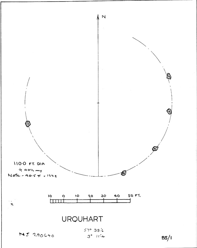
Described in early local history journals, this stone circle of many names is composed of mainly small upright stones — though one of them stands nearly six feet tall — yet it has quite a large diameter of 110 feet (or 40.4 megalithic yards). Alexander Thom (1980) measured its circumference as being precisely 127 megalithic yards. It is thought to have originally consisted of twelve stones, but today only five remain. And in a landscape where recumbent stone circles reign supreme, Aubrey Burl (in Thom, Thom & Burl 1980) thought the lay-out of the site suggestive of just such a monument, saying:
“The apparent grading of the stones towards the S-SSW and the 19th century reference by the Minister of Urquhart to “nine tall stones in a circle, two of them at the entrance to the altar” suggest that this may have been a recumbent stone circle, from which the recumbent and its flankers have subsequently been removed. It is noteworthy that the westernmost stone has several small cupmarks on it, a pillar which would have been close to the recumbent in that restricted area where cupmarks are to be found in recumbent stone circles.”
A singular TNA profile entry of the said cup-marked stone will be added in due course. The middle of the circle was dug sometime prior to 1870, but no human or other remains were found.
Folklore
Described by two local ministers as ‘Nine Stanes’ back in Victorian days, with at least one of the stones being recumbent, it was the great Fred Coles (1906) in one of his many articles on the megalithic remains of Scotland who narrated the following tale, told to him first-hand by a local man called Mr T. Geddie, after some of the standing stones from this circle were removed in the nineteenth century.
“One of the stones,” wrote Mr Geddie, “was to be taken away to be built into a new steading at Viewfield. Mr Brown thinks this was prior to the building of the Innesmill steading, which dates from 1843. No sooner had the Stone been deposited in the toon, however, than uncanny signs and omens began to manifest themselves, and it was resolved to get rid of it. While it was being taken back to its original position, the horse stuck or fell when taking a somewhat steep little brae, and the Stone was taken no further, but buried where it was. The spot it about 80 or 100 yards from the circle.”
Grinsell (1976) also tells the tale that if you visit the circle at midnight and walk round the circle three times, the devil can appear.
References:
Coles, F.R., ‘Report on Stone Circles Surveyed in the North-East of Scotland, Chiefly in Banffshire’, in PSAS 40, 1906.
Grinsell, Leslie V., Folklore of Prehistoric Sites in Britain, David & Charles: London 1976.
Thom, A., Thom, A.S. & Burl, Aubrey, Megalithic Rings, BAR 81: Oxford 1980.
Stone Circle (destroyed): OS Grid Reference – NG 552 172
Also Known as:
Cille Mhaire
Folklore
Omitted from Burl’s (2000) magnum opus, the great Scottish folklorists Otta Swire (1961) is the singular reference to the forgotten stone circle that once existed here. She wrote:
“The site of the old church of Kilmarie and of the stone circle whose proximity no doubt originally called it into being are now no longer to be seen. The ruins of the old church, I am told, were swept away by the sea during that great storm in the 1920s which also blew down the Dunvegan woods. The storm followed not long after the burial near the old church of an unknown sailor taken from the sea, and there were those who believed this to be the cause of the church’s disappearance, for, as the old Gaelic rhyme says: “The sea will search the four russet divisions of the universe to find her children,” and Kenneth MacLeod advises that a body taken from the sea should always be buried near the water’s edge, or the sea, desiring to recover her own, will flood much land in search of it.
“This church is said to have stood on the site of an older church of St. Maelrhuba (Servant of Peace) who was the patron saint of south-eastern Skye.”
References:
Burl, Aubrey, The Stone Circles of Britain, Ireland and Brittany, Yale University Press 2000.
Swire, Otta F., Skye: The Island and its Legends, Blackie & Son: Glasgow 1961.
Stone Circle (destroyed): OS Grid Reference – NY 37 50
Archaeology & History
Listed in Burl’s (2000) magnum opus, this is another long-lost megalithic ring, whose exact location seems to have been forgotten. An early description of the site by William Whellan (1860) told us that,
“There was formerly a circle of rude stones, ten yards in diameter, near the village, supposed to have been the remains of a Druidical temple; and a little distance from it, was a tumulus, three yards high and eight in diameter.”
More than a hundred years later in Waterhouse’s (1985) fine survey, he described the circle, saying:
“It lay near the village of Dalton…near the River Caldew… An 18th century account describes it as consisting of ‘rude’ stones…set in a circle of diameter about 27m. East of the the centre of the circle were four large stones lying on top of each other. They may have been the remains of a cist, or possibly a tumbled cove, like that inside the circle-henge of Arbor Low in Derbyshire. A tumulus may have stood nearby.”
There are however some discrepancies in the descriptions between Whellan and Waterhouse. In the former, the site of Chapel Flat is talked of separately as being the abode of a hermit in the lost chapel of St. Wynemius, “in a deep and romantic part of the vale of Caldew.” The description of the stone circle immediately follows this, but is spoken of as merely being “near the village.”
Does anyone know anything further about this once important site? Did the lost hermitage on Chapel Flat actually have anything to do with the stone circle?
References:
Burl, Aubrey, The Stone Circles of Britain, Ireland and Brittany, Yale University Press 2000.
Waterhouse, John, The Stone Circles of Cumbria, Phillimore: Chichester 1985.
Whellan, William, The History and Topography of the Counties of Cumberland and Westmoreland, Comprising their Ancient and Modern History, W.Whellan: Pontefract 1860.
Go up through Baildon centre and head onto the moors. Crossing the cattle-grid, a coupla hundred yards further up, turn left. Past the small reservoirs on your left, another 100 yards or so and you reach the brow of the hill. As you begin going down the road, there’s a small car-park right by the roadside. The curious remains of the earthworks at the side of the old circle are discernible in the grassland right to its side.
Archaeology & History
Illustrated on the 6-inch OS-map of 1852 as “Site of a Barrow” (similar to how it appears in the image drawn here by Mr. C.N.M. Colls) a short distance below Pennythorn Hill top, there are still considerable traces of the earthworks surrounding the east and southern sides of what was once some form of ring cairn or tumulus that was once at this prominent place in the landscape.
Aerial view of siteThe site was first explored by Mr Colls in 1843 (his results were reported a few years later), who found a loose double-ring of stones, fifty feet across, surrounded by a shallow trench which was most notable on the south and east sides. Two urns were also uncovered near the centre of the ring, nearly two feet down, containing the cremated remains of people. A few years later, the Leeds historian James Wardell (1869) told a most fascinating note about what happened during their excavation, saying:
“This…examination was attended by a circumstance not soon to be forgotten by the persons engaged therein (on the excavation). They had almost reached the place where the broken urn and bones were deposited when, at once, such a fearful storm of thunder, lightning and rain came on, that they were not only considerably alarmed, but driven from the Common to seek shelter in the village.”
Colls’ 1846 sketch
We hear this sorta thing at many of our ancient places!
Colls 1846 plan
One anonymous writer in 1955 described the site as a ‘stone circle’, and a number of subsequent archaeologists copied this without question; but in all probability this site was more typical of an old cairn circle or ring-cairn, similar in size and design to the Roms Law circle two miles north of here. However, the earthworks at its side give the impression of some sort of exaggerated hengiform enclosure.
The place-name element howe strongly indicates a burial site and is a suffix found at many prehistoric tombs across northern England. The prefix ‘acre’ may relate to “a plot of arable or cultivated land, a measure of land (an acre) which a yoke of oxen could plough in a day” (Smith 1956), or may be a corrupted form of the Old English word, ‘acen’, relating to oak trees. Early literary examples of the place-name would enable a clearer understanding of the prefix element here.
References:
Anonymous, Colls’ Burial Mound Stone Circle, Baildon Moor, Museum Leaflets: Bradford 1955.
Baildon, W. Paley, Baildon and the Baildons (parts 1-15), St. Catherines: Adelphi 1913-26.
Barnes, Bernard, Man and the Changing Landscape, Eaton: Merseyside 1982.
Bennett, Paul, The Old Stones of Elmet, Capall Bann: Milverton 2001.
Colls, J.N.M., ‘Letter upon some Early Remains Discovered in Yorkshire,’ in Archaeologia, 31, 1846.
Collyer, Robert & Turner, J.H., Ilkley: Ancient and Modern, William Walker: Otley 1885.
Smith, A.H., English Place-Name Elements – volume 1, Cambridge University Press 1956.
Wardell, James, Historical Notes of Ilkley, Rombald’s Moor, Baildon Common, and other Matters of the British and Roman Periods, Joseph Dodgson: Leeds 1869. (2nd edition 1881)
From Bakewell take the A6 Matlock road, follow this till just past the signs for Haddon Hall where you take a right (the first major junction) for Youlgreave the B5056. After about 1km take the first left over the bridge. You then take the first right turn: a steep lane with restriction signs (don’t worry there’s access for cars but no wide vehicles). Take the first left you come to by the barn and then just follow the road, up through the woodland where the lane narrows then shortly after you’ll see Robin Hood’s Stride to your left. Park a little way after the field gateway and look across the field to your left. The stones are visible from the road.
Archaeology & History
This is a fine-looking ring of stones — though perhaps the word ‘ring’ is slightly misleading here, as only four of (apparently) nine originals still remain and they are, by definition, more in a square-shape than a circle! But it’s a lovely site. When Geoff brought us here for the first time only last weekend, despite the dark clouds and cold grey day, along with the fact that we’d been sleeping rough the night before and got soaking wet through, there was a subtle feel to this place which my shivering senses still touched. Only just though…!
Two southernmost stones
Mebbe it was the rising crags of Robin Hood’s Stride to its immediate south? Or the quietly hidden companionship with other stones and sites in the locale? I don’t really think so. There was something a little more about its own genius loci that tingled very slightly on the rise in the field upon which the circle sits. Some people would, perhaps, acquaint my sense of a subtle genius loci here to the various leys or ley-lines that have been drawn through here by other writers— but it wasn’t that.
When earlier writers came here, they too had various inspirations of differing forms. John Barnatt’s (1978) early impressions of the place had him signing astronomical events in and around the remaining stones here, despite knowing that the site had been damaged. In later years he revised his early notions — as most of us do as our perspectives are enriched — but the astronomy is still assumed here. As Clive Ruggles (1999) told:
“Other rings are located where natural features coincide with astronomical events, such as Nine Stone Close in Derbyshire…from which the Moon at the southern major standstill limit, sets behind the gritstone crag of Robin Hood’s Stride to the SSW, between ‘two stubbly piles of boulders jutting up at either end of its flat top.'”
Major Rooke’s drawing of the Nine Stones Circle, c.1780
The stones that remain here are quite tall, between 6½ and 8 feet tall. One of them seems to have originally been taken from a stream or river-bed. They stand upon the small rise in the field and has diameters of 40 and 45 feet respectively. Aubrey Burl described there being seven uprights still here in 1847, and the early drawing of the site near the end of the 18th century by Major Hayman Rooke highlights 6 stones around the spot where the circle now stands. In J.P. Heathcote’s (1947) summary, he wrote that,
“Bateman, in his Vestiges, says an excavation in 1847 yielded some indications of interments in the form of ‘several fragments of imperfectly-baked pottery, accompanied by flint both in a natural and calcined state.’ In 1877, Llewellyn Jewitt and Canon Greenwell…turned their attention…to the Nine Stones. They dug at the foot of the second highest stone and the Canon directed a good deal of digging within the circle, but nothing special turned up. The area in the circle is now quite level, but it is probable that there was, as Bateman says, a tumulus in the centre.”
This latter remark is the impression I got of the place. Tis a really good little site. All around here are a number of other sites: cup-marked stones, enclosures or settlements, prehistoric trackways, and more.
Folklore
One of the old names of this site was The Grey Ladies. This came from the well known tale found at other sites across the world, that some ladies were dancing here at some late hour and were turned into stone. A variation on this theme told how Robin Hood stood on the nearby rock outcrop to the south and pissed over the landscape here, “where seven maidens upon seeing it turned to stone.” In this case, Robin Hood replaced an older, forgotten account of a giant, who forged the landscape and the sites around Harthill Moor.
Another tale — whose origins and nature are allied to that of the petrification of the Grey Ladies — narrated with considerable sincerity by local people, was that the circle was a place where the little people gathered and where, at certain times of the year, “fairy music and the sight of hundreds of dancing shapes around the stones” would happen.
Said by Rickman and Nown (1977) to be “Derbyshire’s most magical ancient site,” they thought the site was on a ley that linked up with Arbor Lowe, less than 5 miles west, crossing a couple of tumuli on its way.
References:
Barnatt, John, Stone Circles of the Peak, Turnstone: London 1978.
Burl, Aubrey, A Guide to the Stone Circles of Britain, Ireland and Brittany, Yale University Press 1995.
Clarke, David, Ghosts and Legends of the Peak, Jarrold: Norwich 1991.
Heathcote, J. Percy, Birchover – Its Prehistoric and Druidical Remains, Wilfrid Edwards: Chesterfield 1947.
Rickman, Philip & Nown, Graham, Mysterious Derbyshire, Dalesman: Clapham 1977.
Ruggles, Clive, Astronomy in Prehistoric Britain and Ireland, Yale University Press 1999.
Thom, A., Thom, A.S. & Burl, Aubrey, Megalithic Rings, BAR: Oxford 1980.
Park up at Cut Throat bridge on the A57 or alternatively at the huge parking area that’s signposted a little further uphill. Either way, the easiest access point is at Cut Throat Bridge – though be aware the route between the two areas is the narrow grassy verge of the road: take care, kids and dogs on a very short rein! There are many ways to access the circle but I’ll deal with only two here: one, a scramble up the steep bank of the edge; and the other, a longer route which takes in a quite a steep path, but is much easier than the first option if you’re not up for a scramble!
Route 1: The shorter scrambly route – Climb the stile into the wooded area & follow the path till your out of the wood, carry on for another 100 metres then head to your left & up the banking. The circle is thereabouts 40 metres onto the moor in the grassland, not the heather.
Route 2: The longer way but following a relatively easy path – Access the moor via the stile and just follow the path for around ½-mile till it veers to the left at Jarvis Clough & takes a steep route uphill. You then need to head left along the edge for around ¼-mile till you see the circle off to your right in the grassland.
Archaeology and History
Don’t let the bastardization of this site’s name fool you! The seven stones actually number between 9 and 24, depending on the season and the growth around them. They’re laid out in a rough free standing circle around 15.5 metres in diameter.
Hordron Edge looking across to Lose Hill
One of the largest stones to the SW is said to mimic the profile of Lose Hill — which it does sort of if you have a vivid imagination. But it’s not half as close as the top of the stone matches the profile of Lose hill off to your right. It is a complete coincidence of course. The stone has suffered much weathering over the millennia and I’m in no doubt it wasn’t an intended original feature. (see pic, right)
Previously, and at some time preceding the 1992 excavations at the site by John Barnatt, the circle was “tampered” with, leading to a thorough investigation that unearthed several more buried stones, one of which was re-erected.
All in all a fantastically preserved circle and one of the best examples in Derbyshire that’s well worth the effort of a visit. Watch the weather though; as on all but one of my visits I’ve been drenched!. The “wow” factor of this site however, makes that a small price to pay for such an awe-inspiring excursion. With Win Hill and Lose hill looming large to the southwest, Stanage Edge off to the southeast and the great outcrop of Ladybower Tor with it’s rock art to the west, this circle has some of the best scenery of any the circles in Derbyshire.
Folklore
The stone that alleges to line-up with Lose Hill is also known by some of the more imaginitive as the Fairy Stone and there have been reports of strange lights and other phenomena reported around it. I’ve been up here on probably a dozen occasions and never witnessed anything strange — but then I’m often accused of being closed-minded. Another way of saying “non gullible” in my book!
References:
Armitage, Harold, Early Man in Hallamshire, Sampson Low: London 1939.
Barnatt, John, Stone Circles of the Peak, Turnstone: London 1978.
Burl, Aubrey, The Stone Circles of Britain, Ireland and Brittany, Yale University Press 2000.
Thom, A., Thom, A.S. & Burl, Aubrey, Megalithic Rings, BAR 81: Oxford 1980.
Located just off Hathersage Road, by Parsons House outdoor pursuits centre with parking in a roadside layby. Don’t Park at Parsons House – they won’t like it! Head up the old road besides Parsons house and take the entrance onto the moor about 100 metres past the pursuits centre track. If memory serves me correct, it’s by the second wall on the right. Follow the post-and-mesh fence to the end of the wall and turn right, following the wall for around 70 metres down hill and you’ll be able to see the cairn’s bank before you in the heather. The stone pictured lays in the banking by the entrance which faces NNW.
History and Archaeology.
There’s no excavation taken place here that I know of, but the site is well known and mentioned in an old report I found Here. The article also contains an old map of the area showing the site.
Also mention is made of a stone referred to as the Fingeram stone. There is a stone laid flat in the position marked on the map, but I’m unsure whether it’s the standing stone mentioned. According to the old text the ring cairn has a diameter between 83ft and 95ft. Directly to the north and roughly 50 metres onto the moor, in line with the wall, is an interesting egg-shaped and weather-worn boulder that’s also worth a look at. This whole area is a sea of sandstone.
Follow Redmires road till you come to Wyming brook nature reserve and use the free parking facilities there. From the car park you need the signposted path to the right of the notice board, the first one not the one by the metal barrier; climb the rocky steps and follow the line of the dry stone wall to your left, and after around 50 metres you’ll pass through a wooden gate. You then continue following the wall as it heads downhill and the wall becomes broken. Here you should notice a path that goes through the broken wall off to your left: don’t take it but continue another 50 metres or so, then turn 90° to your right facing the moorland. The circle is around 50 metres into the heather.
Ash Cabin Flat Stone Circle – as of 26/5/09
Archaeology & History
A fairly well preserved late neolithic or early Bronze age embanked stone circle located in a sea of heather on Ash Cabin Flat on the Western outskirts of Sheffield and rediscovered in 1981 due to the moor being burnt back.
The site is oval in shape and around 9m x 7m diameter to the outer edge of the bank. The banking is well preserved and shows there was no entrance to the interior.
There are around a dozen stones within and on top of the bank but it’s uncertain whether they are circle stones or packing stones from the bank. English Heritage have recorded 5 of the stones, 2 still standing, as stones that once stood making up the circle.
If you visit any time soon (23/11/09) you’ll find the moor has been burnt back again giving an excellent view of the site, when the heather is in full flow it’s as high as the highest stones making not only finding the circle nigh on impossible to find but also defining the site very difficult.
Additional Notes:
Editor – 1.12.9. – Following a visit to this site in the company of Megadread recently, we found what appears to be a number of other cairns on the flat moorland plain around this seeming cairn-circle site. There also appeared to be distinct evidence of ancient walling. Further archaeological evaluations are required here.
References:
Burl, Aubrey, The Stone Circles of Britain, Ireland and Brittany, Yale University Press 2000.
Stone Circle (destroyed): OS Grid Reference – SP 470 464?
Also Known as:
Ringstone Well
Archaeology & History
In 1239 CE we find records of a field-name site called “Ringstoneswelle.” Although the place-name writer Margaret Gelling (1954) initially ascribed this as the watering-place of some dood called Hringstan, it is in fact the only record that I’ve found of a “stone circle by a well” in the village. This etymological root is confirmed in A.H. Smith’s English Place-Name Elements (vol.1, p.265) as a probable stone circle.
Folklore
There is also the curious field-name legend of a place in Cropredy called Kirk or Church Piece, where a christian church was being built, but in the morning all the stones had been uprooted & moved back from whence they came. This happened several times according to the folktale – a story that has with all the hallmarks of a megalithic site. (see Grinsell’s Folklore) To me it seems likely that the nearby Cup and Saucer Stone also had something to do with this lost stone circle.
In the same area we have another intriguing bit of folklore that was reported in an early edition of the Banbury Guardian (1932) which told that,
“on one of the top stones of a wall in front of one of the farmhouses is what is supposed to be the Devil’s footprint and there are nail-marks in the stone, but how it gots it name is a puzzle. At the back of the vicarage gardens is a small jetty called HellHole, the old ‘Old Man’ must have visited this village a time or two.”
Are there any local antiquarians or historians who can throw further light on this seemingly lost megalithic ring?
References:
Anonymous, ‘Cropredy and its Legends,’ in Banbury Guardian, December 29, 1932.
Bennett, Paul & Wilson, Tom, The Old Stones of Rollright and District, Cockley: London 1999.
Gelling, Margaret, The Place-Names of Oxfordshire – volume 2, Cambridge University Press 1954.
Grinsell, Leslie V., Folklore of Prehistoric Sites in Britain, David & Charles: London 1976.
Smith, A.H., English Place-Name Elements – Part 1, Cambridge University Press 1954.
From Ripponden, taken the steep road up to Barkisland, but at the crossroads just before the village, turn right (south) and keep going for a mile till you reach the reservoir. At the far-end of the reservoir, take the track down by its side and follow the footpath that bends round the edge of the grasslands. Go up onto this small moorland and, once you’re on the level, head towards where you’ll see a large pile of stones a coupla hundred yards away. That’s it!
Archaeology & History
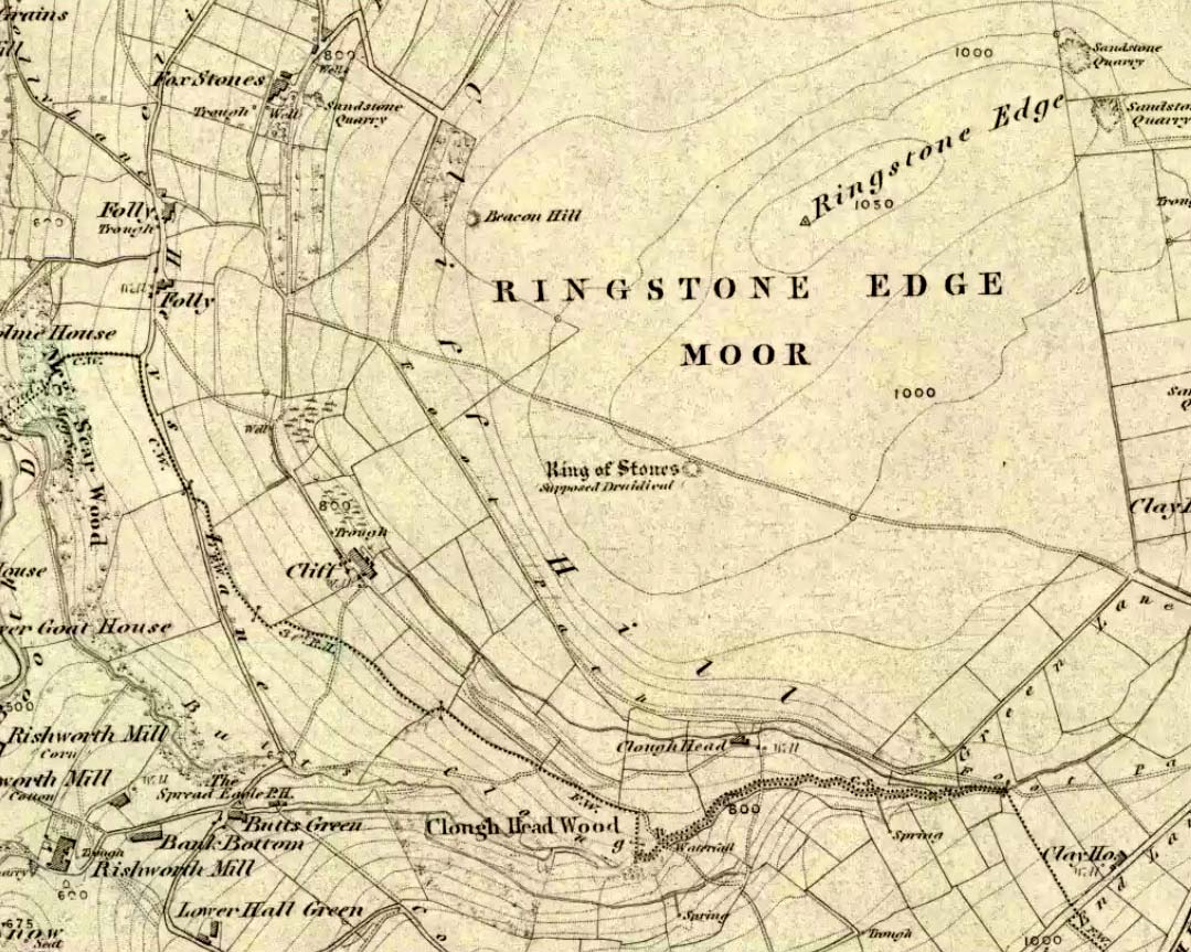
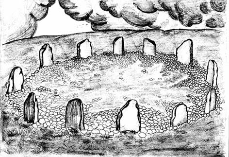
If we visit this site today, all we are left with is a scattered mass (or perhaps that should that be ‘mess’) of many hundreds of stones: the last remnants of what once would have been a proud circle of one form or another upon this small moorland plain. Its significance was such that the very moor on which its remains are scattered, was named after it: the Ringstone Edge Moor. But as with many sites from our megalithic period, this old place is but a shadow of its former self.
Gone are the upright monoliths which, tradition relates, once surrounded this low scattered circle of small loose stones (which would have made it look not unlike the wonderful stone circle of Temple Wood, Argyll). These standing stones were, so the folk record tells, removed near the end of the 18th century for use in some walling.
Described variously as a stone circle, ring cairn, cairn circle, an enclosure, and more, the site first seems to have been written about in 1775 by the great historian John Watson. When he was vicar of the local parish in Halifax (not far from here) this “ring of stones” as he called them, was “called the Wolf-fold.” Nearly one hundred years later, in F.A. Leyland’s superb commentary to Watson’s work, he wrote,
“The stones which constituted the circle at the time of their removal stood upwards of three feet…and the remain formed a striking object on the moor. The original number of stones of which the circle was formed is unknown, having long been in ruin and reduced in quantity before being finally removed. This was effected about twelve years since by the present tenant of the dam.” – that is, around 1859.
However, when Crabtree (1836) described the circle a decade or two earlier, he made no mention of such standing stones — although we must consider that Crabtree was very much like many modern academic archaeologists who tended to copy the works of others, much less than getting out in the field to see for himself.
At the beginning of the 20th century, the lore telling of the standing stones’ demise was repeated by local historian John Priestley (1903), when he said that: “all the large stones…were carted away about forty years ago” — that is, around 1863.
So it would seem that the very final destruction of the standing stones here, occurred sometime during the four year gap which Messrs. Leyland and Priestley describe.
More than fifty years later, Huddersfield historian James Petch (1924) came here to explore whatever remains he could find, and told:
“On top of a flat plateau on this moor, with an extensive view on all sides save on the north, where there is a gentle slope for some hundreds of yards up to the summit of the hill, there are distinct traces of a circular ring of small stones. Pygmie flints have been picked up within a yard or two, but the only other fact to be noted about this earthwork is that there is a tradition to the effect that much earth has been removed from this site. It is not altogether impossible that this is a scanty remnant of a round barrow.”
This latter remark of Mr Petch seems most probable. The excessive scatter of small stones typifies the remains of many of the Pennine giant cairns, from the Little Skirtful on Burley Moor and giant tombs of the Black Hills near Skipton, to the similar monuments of our Devil’s Apronful, Pendle, etc, etc.
Close to this cairn circle, wrote Sidney Jackson (1968), there used to be the remains of an Iron Age settlement, “marked by wall foundations (but) is now covered by the waters of Ringstone Reservoir.”
Folklore
There is very little folklore that I’ve found here. Watson (1775) throws the usual idea that the place was a site of druidical worship; but other than that we only have a local Ripponden writer’s account, which told that there was once the ghost of a white lady that was once said to walk along the path somewhere between here and the Beacon Hill tumulus, a short distance to the north.


")