On the east side of Warrengate Road, approached from Welham Green via Dixons Hill Road, or from Brookmans Park via Bradmore Lane.
Archaeology & History
1920 photo of the Public House. The Maypole is thought to have been in the grounds to the rear
The exact position of the pole is not marked on the 1896 25″ OS map, as it is probable that it had been removed by the middle of the nineteenth century (like the majority of the permanent Hertfordshire maypoles), but local belief in the 1950s and 60s was that it had been in the garden of the Old Maypole (originally known as ‘The Maypole’) public house, which adjoined the smithy in Warrengate Road, Water End. The public house is stated to have been built around 1520, with later additions, but is now a private house.
The population of Water End and nearby Welham Green was predominantly employed in agriculture, domestic service and straw plaiting, but the area’s proximity to London probably speeded the demise of the ancient traditions like maypole dancing .
The 1896 OS-map showing the grounds to the rear of the pub
Doris Jones-Baker writes: “The old Hertfordshire maypoles, on May Day decorated with ribbons and a bunch of spring flowers at the top, were described as being ‘as high as the mast of a vessel of a hundred tons, painted often in a diagonal or spiral pattern from bottom to top in yellow and black, or often in vertical stripes of red, white and blue’”
Interestingly, the rear of the public house garden adjoins the Swallow Holes, a geological feature where the intermittent flowing waters of the Mimmshall Brook disappear into the chalk in as many as 15 sink holes. Hertfordshire has an ancient tradition of ‘woe-waters’ related to the local geology, where the flowing or not of a stream or spring was seen to herald ‘sorrow to come’. From personal memory the Mimmshall Brook is normally a dry stream bed which can in winter suddenly turn into a raging torrent, flooding the land behind The Old Maypole. Any tradition of it having been a woe-water has though been lost. But it is just possible that long ago the coming of May Day was also seen to herald the end of flooding of the Mimmshall Brook and may explain the siting of the pole.
The last year that people danced is not recorded, but the local maypole tradition continued; this writer remembers ribbon dancing as a very small child to a fiddle accompaniment around a maypole erected at the nearby, but long demolished Waterend C.E. Primary School, which closed in 1960.
Folklore
As well as Maypole dancing, Hertfordshire had a rich tradition of May day ritual and song, which despite the county’s proximity to London, survived long enough for some of it to be recorded for posterity. While there does not seem to be any ritual recorded for North Mymms, the following was recorded at nearby Hatfield. “On may morning, dressed in white and holding bunches of Hawthorn or, in late seasons, blackthorn blossoms the children sang door to door a local version of the May song, which began:
‘A bunch of May I bring unto you
And at your door I stand,
Come pull out your purse,
You’ll be none the worse
And give the poor Mayers some money….’”
References:
North Mymms Local History Society, North MymmsPictures From The Past, Welham Green, 2002
Jones-Baker, Doris, The Folklore of Hertfordshire, B.T.Batsford, London, 1977
Kingsford, Peter, North Mymms People in Victorian Times, Brookmans Park, Hertfordshire, Privately Published, 1986
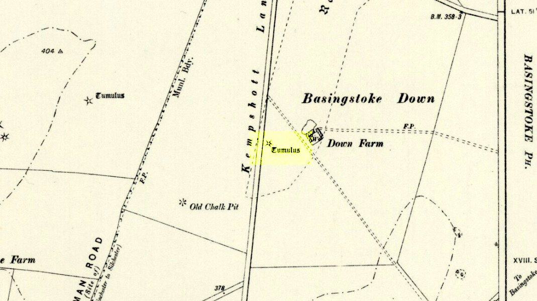
Barrow (destroyed): OS Grid Reference – SU 6018 5013
Archaeology & History
Downs Farm tumulus on 1897 map
On the western edges of Basingstoke, at Kempshott, could once be found this ancient site—destroyed many decades ago. It was one of number of similar prehistoric burial mounds in the area. First described in a listing of tumuli by Mr Andrews (1898) who told us that it was “oval” in shape, the monument was completely destroyed in 1939 and according to the Royal Commission (1979) lads,
“its site now lies beneath a house at the southwest corner of Kempshott Lane and Homesteads Lane.”
When the house where it once stood was being constructed, a collared urn was recovered from the tomb, which the Royal Commission thought indicated “that the monument (was) likely to have been of early Bronze Age date”—but obviously we cannot be sure. The site was listed in Leslie Grinsell’s (1979) extensive survey of prehistoric tombs in the area, in which he suggested it may have been a long barrow.
References:
Andrews, S., “A Short List of Some Tumuli in North Hampshire,” in Proceedings of the Hampshire Field Club & Archaeological Society, volume 4, 1898.
Grinsell, Leslie V., “Hampshire Barrows – part 3,” in Proceedings of the Hampshire Field Club & Archaeological Society, volume 14, 1940.
Royal Commission on Historic Monuments, England, Long Barrows in Hampshire and the Isle of Wight, HMSO: London 1979.
Willis, G.W., “Bronze Age Burials round Basingstoke,” in Proceedings of the Hampshire Field Club & Archaeological Society, volume 18, 1953.
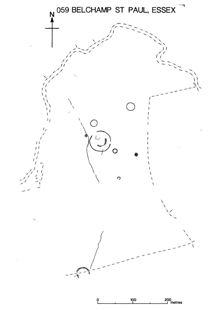
Several hundred yards northeast from Hickford Hill, a cluster of prehistoric sites could once be seen close to each other just south of the River Stour below line of the Essex-Suffolk county boundary. Several of these were tombs and are accounted for in Priddy’s (1981) essay on the prehistoric Barrows of Essex; but adjacent to them were also found faint traces of a large circular enclosure of some sort, which Harding & Lee (1987) included in their definitive survey of British henge monuments. Their account of it was brief and simple, saying:
“Enclosure defined by the cropmark of a sub-circular rather narrow ditch broken by two entrances. No trace of a bank. Internal traces of a concentric innner ditch in part of the circuit… Internal diameter range 56-57m…; width of outer ditch c.1.5-2.5m; width of entrances, c.7m (E) and 16m (NW); width of inner ditch c.2.5-5m.”
Although this large ringed enclosure was thought by the Haverhill & District Archaeology Group to “be a henge-type monument,” Harding & Lee (1987) thought it unlikely that these remains “belong to the henge class” of monuments. A brief archaeological dig into one of the trenches here in 1997 showed the site to be Bronze Age; but finds by the local archaeology team have also come across finds in the fields hereby dating from the Mesolithic and Neolithic periods.
References:
Harding, A.F. & Lee, G.E., Henge Monuments and Related Sites of Great Britain, BAR 175: Oxford 1987.
Priddy, D., “The Barrows of Essex,” in A.J. Lawson’s The Barrows of East Anglia, Norfolk Museums Service 1981.
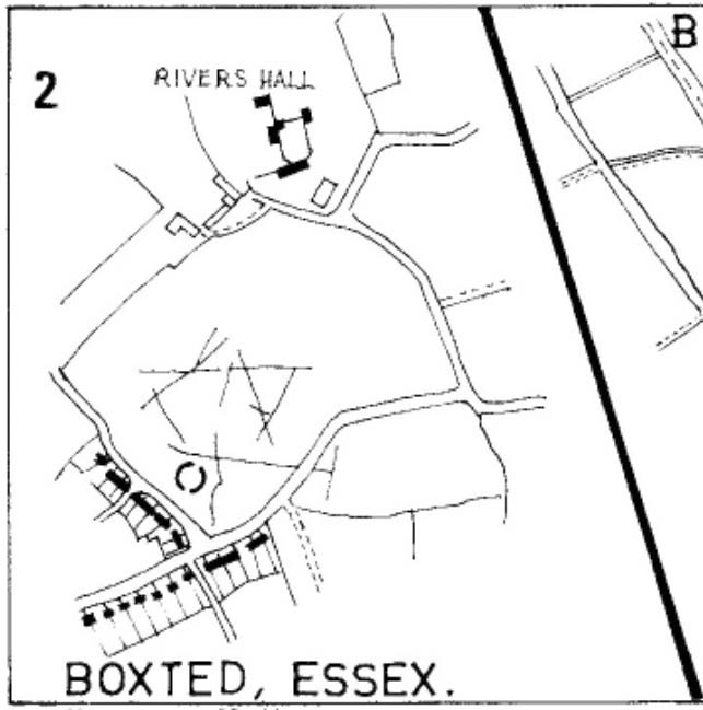
As with many sites in Southern England, intensive agriculture has taken its toll on the archaic monuments. The Boxted Cross henge is no exception and hardly any elements of it remains today. But it seems that it was an impressive fella in our more ancient heathen past.
The site was only rediscovered in the 1970s and was first described in Mrs Ida McMaster’s (1975) survey of crop-marks that had been revealed by aerial surveying in Essex and Suffolk counties. Her brief account of the monument told it to be,
“A Class II henge with a wide somewhat ploughed out ditch. Various linear ditches are near, together with prolific variegated ‘field outlines’ of glacial subsoil cracking which extends into the next field southwards. The ditch terminals of the southwest entrance to the henge appear to be wider than the general run of the ditch, say 4-5 metres.”
When Harding & Lee (1987) examined the site, they were a little more cautious in their interpretation of it being a definite henge, citing that there was “insufficient information, but cannot be ruled out as henge-related,” adding that it “could also be a mill.” This latter element seems unlikely, though a windmill may have been built onto the site at a later date.
More recently however the site has been categorized by Historic England as “a Late Neolithic henge.” The monument itself was defined by a broad circular ditch with two large opposing entrances to the north and south. The total diameter of the enclosure is 44 yards (40m) across; but with the surrounding ditch measuring 5½ yards (5m) across all around, the inner level of the henge was about 33 yards (30m) in diameter. Plenty of room for partying old-style!
References:
Harding, A.F. & Lee, G.E., Henge Monuments and Related Sites of Great Britain, BAR 175: Oxford 1987.
Take the Calverton Road out of Stoney Statford, then take the left hand road to Calverton and look for layby on the right near a copse.
Archaeology & History
Gorrick’s spring is an interesting site and perhaps the best of the county’s holy wells. The water flows from a rather worn lion’s head beneath a stone arch under the steps, and pours into a stone lined chamber repaired with concrete slabs. It is reached by a series of steps from the layby and beside the spring is a narrow and as Rattue (2003) states an uncomfortable seat.
Folklore
It is unclear where the name comes from but a local legend tells how a witch’s pupil gave the sight back to a Gypsy tinker. A rhyme states in Romance around Stoney Stratford quoted by Rattue (2003):
“When Gorrick’s Spring flows fast and clear,
Stoop down and drink, for health is here,
If Gorrick’s Spring shuld e’er run dry,
Beware, for pestilence is nigh.”
Interestingly it did run dry in 1996 as noted in the local Herald of 8th November 1996:
“It’s a mystery,” confessed Calverton resident Lucinda Lourie. She said she realised water levels were currently low, but older residents of the village remembered the spring running through the drought of 1976. She said one wag at Anglian Water had suggested the source of the spring may have been a burst pipe which the Anglian Water work had cured – unlikely since the spring is reputed to have been used by monks in the 13th century!”
An author named Bartley (1928) mentioned by Rattue (2003) in his Holy Wells of Buckinghamshire notes:
“the monks of old….deemed the delicious waters of this wayside spring as sacred, possessing healing properties for all humans. Daily the holy Friar would hie to the mossy bank and reach the water with his ancient pitcher, and bear it homeward to his suffering flock”
As Rattue (2003) notes it appears unlikely that a friar would have visited the site as there is no record of any religious institutions connected with the site.
Extracted and amended from the below post (which also discusses St Rumbold’s Well)
This much disturbed Iron Age ‘hillfort’ is effectively a large enclosure of Iron Age origin, much ruined by farming and subsequent landscape alterations through the centuries, with much of it re-fashioned as a medieval moat more than a thousand years after first being built. Even when the site was visited and described in Mr Wadmore’s (1920) fascinating work he told of the variants in its apparent construction phases:
“This large earthwork is situated on flat level ground, a few yards off the Bedford-Kimbolton Road, at the VIIth milestone out of Bedford. In shape it is very irregular and presents little to aid one in arriving at an estimate of its original form, except the construction of its defensive lines, which are of two totally different characters and suggest that a comparatively modern manor has been added to an older work.
“The portion which I take to be the older, lies to the south, and is contained on this and the western side, as far as and including the great sweep bending east, by a strong vallum with a parapet and external fosse.
“The modern portion appears to me to commence between the east and west faces where the lines run north, and are purely the remains of a fosse without any indication of a parapet. The extension of these lines, so far as can be traced, would tend to prove that the work occupied both sides of the road; but such a fact should not prejudice one’s view concerning the work as a whole….”
Section of the earthworks drawn by Wadmore
Adding with a good sense of humility that, “I am quite willing to admit that I may be mistaken, as the matter is entirely speculative.” But modern archaeological analysis tends to prove that much of Wadmore’s words were correct and the remaining northern section of these earthworks is where the medieval moated section was built. Roman remains and other period artifacts have also been unearthed in and around the site.
A few hundred yards southwest of the hillfort we find a place called Greenbury Farm. This place was known in the 14th century as ‘Grymesbury’, which has been taken by some students as relating to the Norse deity, Grim. However, Mawer & Stenton (1926) point out that in this instance,
“The Grym family had a holding in Bolnhurst in 1302 and bury is here used in the manorial sense. Hence ‘Grym’s Manor.’”
References:
Mawer, A. & Stenton, F.M., The Place-Names of Bedfordshire and Huntingdonshire, Cambridge University Press 1926.
Wadmore, Beauchamp, The Earthworks of Bedfordshire, Bedfordshire Standard: Bedford 1920.
Long Barrow (destroyed): OS Grid Reference – TL 086 268
Archaeology & History
Aligned east-west, a large neolithic long barrow could once be seen to the west of Galley Hill, on where now we find a golf course. It was sadly destroyed sometime around 1900 AD and its demolition was witnessed by a Mr A. Cumberland of the Dartford Antiquarian Society, who reported there being no archaeological finds of note in the tomb. Curious…
Equally curious was the view of archaeologist James Dyer (1964) in his assessment of the site, who wrote how
“Air photographs suggest that the barrow was 300 ft long, but this is much larger than normal in the Chilterns, and 150 ft is more reasonable.”
The neolithic and Bronze Age burial specialist Paul Ashbee (1984) maintained the “300 feet” measurement.
Other tumuli can still be seen on the slopes either side of Galley Hill a few hundred yards to the east; and a henge monument has also be found in the area.
References:
Ashbee, Paul, The Earthen Long Barrow in Britain, Geo: Norwich 1984.
Dyer, J.F., “A Secondary Neolithic Camp at Waulud’s Bank, Leagrave,” in Bedfordshire Archaeological Journal 2, 1964.
‘Standing Stones’: OS Grid Reference — TL 1395 9839
Also Known as:
St. Edmund’s Stones
Archaeology & History
1885 OS-map of the site
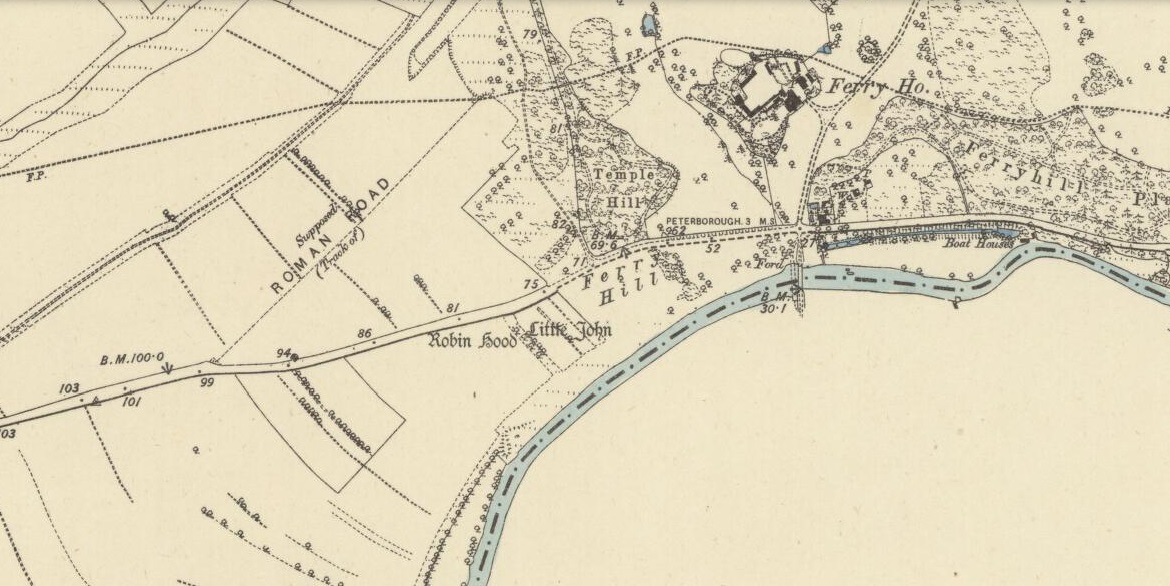
A curious and intriguing site with as many questions about its nature as there is its folklore. Moved around by the conniving fuckwit politicians from Huntingdonshire, to Northants to Cambridge nowadays, one wonders where those fools will place it next! Listed by a number of archaeologists as prehistoric standing stones, it seems pretty obvious from photos and the descriptions of many amateur students that—unless some original monoliths have been reworked a few centuries back—the narrative given by local historian W.H.B. Saunders (1888) outlines their more probable origin and history. That’s not to say that the stones aren’t old—just not that olde…. Mr Saunders reasoned that they were dug and transported from more than 5 miles northwest of their present spot, telling that:
“Nothing can rob the stones of their undoubted antiquity. The Barnack quarries have been exhausted for the last 600 years at least. It is evident therefore, that the stones were placed in their present position at a time when the Barnack quarries were being worked. That would be in the days of Robin Hood, and also when the Abbey of St. Edmund’s Bury, built of Barnack stone, was being erected.”
His words make sense when you look at the stature of the monoliths in question. They’re cut and squared to the edges, with Robin Hood being the taller of the two stones, about 30 feet southwest of the Little John stone. They have been written about quite extensively by historians down the centuries, from William Camden onwards. One early account of the stones was written by Symon Gunton (1686) who told:
“I find in the charter of King Edward the confessor…that the abbot of Ramsey should give to the abbot and convent of Peterburgh 4000 eeles in the time of Lent, and in consideration thereof the abbot of Peterburgh should give to the abbot of Ramsey as much freestone from his pitts in Bernack, and as much ragstone from his pitts in Peterburgh as he should need.
“Nor did the abbot of Peterburgh from these pits furnish only that but other abbies also, as that of St. Edmunds-Bury: in memory whereof there are two long stones yet standing upon a balk in Castor-field, near unto Gunwade ferry; which erroneous tradition hath given out to be draughts of arrows from Alwalton church-yard thither; the one of Robin Hood, and the other of Little John; but the truth is, they were set up for witnesses, that the carriages of stone from Bernack to Gunwade-ferry, to be conveyed to S. Edmunds-Bury, might pass that way without paying toll; and in some old terriars they are called St. Edmund’s stones. These stones are nicked in their tops after the manner of arrows, probably enough in memory of S. Edmund, who was shot to death with arrows by the Danes. The balk they stand upon is still call’d St Edmund’s Balk. They are supposed to be the petrify’d arrows of those two famous archers.”
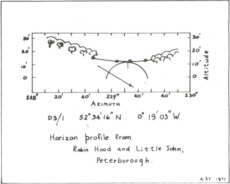
Thom’s sketch showing his midwinter alignment
These traditions have subsequently been copied by all local historians. So it is something of a curiosity to find our archaeologists—from Clarke (1960) and F.M. Pryor (1972) to Aubrey Burl (1993)—to cite these as prehistoric monoliths. My suspicions as to their reasons relates to the folklore of the stones which are echoed at many truly prehistoric places like the Devil’s Arrows, etc. The nature of the tale is an aboriginal creation myth, relating to the formation of sites as understood in animistic mythic structures. But this archaeological misunderstanding brought the more scientific mathematical mind of Alexander Thom (1990:1) here in the 1980s where coincidence showed a common astronomical alignment. Thom wrote:
“Clearly visible from the site, at an azimuth of 229°.22 is the lowest point of a low saddle on the horizon. The col, Fig.1 (above), subtends an arc of about 0°.67 of azimuth, observed minimum altitude 0°.21. For an estimated temperature of 44°F, correction for refraction at sunset is about 0°.54, and for solar and semi-diameter and parallax of respectively 0°.27 and 0°.002, the ‘observed’ declination is found to be -23°.92, which indicates a date of about 1860 BC.
“No presently obvious horizon marker was evident upon inspection of the open fields forming the horizon, but this does not mean that a foresight was never erected. Without the evidence of a foresight it cannot be claimed that the two stones were placed for accurate calendrical reasons, but undoubtedly they indicate by themselves the winter solstice.”
The folklore may indicate the possibility that these two medieval standing stones replaced earlier ones, but no remains of such relics exist today.
References:
Burl, Aubrey, From Carnac to Callanish, Yale University Press 1993.
Clarke, R. Rainbird, East Anglia: Ancient Peoples and Places, Thames & Hudson: London 1960.
Gover, J.E.B., Mawer, A. & Stenton, F.M., The Place-Names of Northamptonshire, Cambridge University Press 1975.
Grinsell, Leslie V., Folklore of Prehistoric Sites in Britain, David & Charles: London 1976.
Gunton, Symon, TheHistory of the Church of Peterburgh, Richard Chiswell: London 1686.
Mee, Arthur, Bedfordshire and Huntingdonshire, Hodder & Stoughton: London 1973.
Morton, John, The Natural History of Northampton-shire; with Some Account of the Antiquities – 2 volumes, R. Knaplock: London 1712.
Pryor, F.M., Prehistoric Man in the Nene Valley, Nene Valley Research: Peterborough 1972.
Saunders, W.H.B., Legends and Traditions of Huntingdonshire, Simpkin Marshall: London 1888.
Holy Well (destroyed): OS Grid Reference – TQ 3096 8106
Archaeology & History
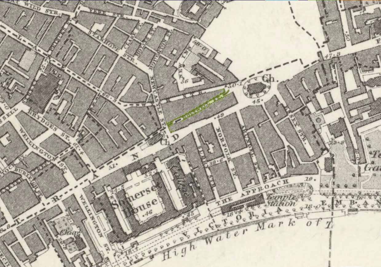
Close to the long-lost Strand Cross and long-lost Strand Maypole, in bygone centuries was also to be found a holy well of great repute, dedicated by early christians to the sea-faring St. Clement. Its presence was recorded in the ‘Holywell Street’ name at far the eastern end of The Strand but, like its compatriot monuments, it too is long-lost… Thankfully we have reasonably good accounts of its existence, although its precise whereabouts has been something of a matter of debate.
Holywell Street on 1868 mapSt Clements Well on 1914 map
The site is certainly of considerable antiquity, as evidenced in the early citations of the street-name ‘Holywell Street’. The earliest reference is found in legal records from 1373, where it was described as “viam regiam que vocatur Holeway“, or “the main road which is called the Holy way.” Several other references name the street as ‘Holwey’ and ‘Holewlane’, before it became shown as ‘Holliwell Street’ on the 1677 “Large and Accurate Map of the city of London” (I can find no copy of this on-line that allows for a reproduction of it on here, sadly). The following year, William Morgan cited it as being ‘Hollowell street’, but curiously the place-name writers Gover, Mawer & Stenton (1942) opted that the name derives from it being a ‘hollow way’ and not relate it to the holy well which we know was located at the far eastern end of the now-missing Holywell Street. I think they gorrit wrong on this occasion!
The best historical narrative of the site is undoubtedly that by Alfred Foord (1910), whose lengthy research waded through all the possible locations of the site, concluding in the Appendix of his work that, “in front of Clement’s Inn Hall…was the far-famed ‘holy well’ of St. Clement.” It’s best leaving Mr Foord to do all the talking on this one:
“The earliest mention of the well of St. Clement was made by the Anglo-Norman chronicler, FitzStephen, in his History of London, prefixed to his Life of Becket (written between the years 1180 and 1182), where in the oft-quoted passage, he describes the water as “sweete, wholesome, and cleere,” and the spot as being ”much frequented by scholars and youths of the Citie in summer evenings, when they walk forth to take the aire.”
“Turning to Stow (1598), a fairly correct idea of the position of the holy well may be formed from his remarks. Referring to Clement’s Inn, he defines it as “an Inne of Chancerie, so called because it standeth near St. Clement’s Church, but nearer to the faire fountain called Clement’s Well.” As to its condition at the time he wrote, he says: “It is yet faire and curbed square with hard stone, and is always kept clean for common use. It is always full and never wanteth water.” Seymour writes of it in his Survey of London (1734-35) as “St. Clement’s pump, or well, of note for its excellent spring water.” Maitland (1756) says of it: “The well is now covered, and a pump placed therein on the east side of Clement’s Inn and lower end of St. Clement’s Lane.” This appears to be the first specific reference to the change from a draw-well to a pump. Hughson (1806-09), and Allen (1827-29) both allude briefly to the well, but the following authors say nothing about it : Northouck, A New History of London (1773); Pennant, Some Account of London (1790 and 1793); Malcolm, Londinium Redivivum (1803-07); and Riley, Memorials of London and London Life in the Thirteenth, Fourteenth, and Fifteenth Centuries (1868).
“Among the more modern writers, John Sanders in his “Strand” article, published in Knight’s London (1842), says: “The well is now covered with a pump, but there still remains the spring, flowing as steadily and freshly as ever.”
“George Emerson (1862), in speaking of the Church, says: ”It stood near a celebrated well, which for centuries was a favourite resort for Londoners. The water was slightly medicinal, and having effected some cures, the name Holy Well was applied.”
“John Diprose, an old inhabitant of the parish of St. Clement Danes, in his account of the parish (published in two volumes in 1868 and 1876), has this passage on the subject: “It has been suggested that the Holy Well was situated on the side of the Churchyard (of St. Clement), facing Temple Bar, for here may be seen a stone-built house, looking like a burial vault above ground, which an inscription informs us was erected in 1839, to prevent people using a pump that the inhabitants had put up in 1807 over a remarkable well, which is 191 feet deep, with 150 feet of water in it. Perhaps this may be the ‘holy well’ of bygone days, that gave the name to a street adjoining.” Timbs says in his Curiosities of London (1853), “the holy well is stated to be that under the ‘Old Dog’ tavern, No. 24, Holywell Street.” Mr. Parry, an optician in that street, and an old inhabitant, held the same opinion. Mr. Diprose, on the other hand, finds “upon examination, no reason for supposing that the holy well was under the Old Dog tavern, there being much older wells near the spot.” Other inhabitants believe that the ancient well was adjacent to Lyon’s Inn, which faced Newcastle Street, between Wych Street and Holywell Street. In the Times of May 1, 1874, may be found the following paragraph, which reads like a requiem: “Another relic of Old London has lately passed away; the holy well of St. Clement, on the north of St. Clement Danes Church, has been filled in and covered over with earth and rubble, in order to form part of the foundation of the Law Courts of the future.” On the 3rd of September of the same year (1874) the Standard refers to this supposed choking up of the old well, and suggests that “there had been a mis-apprehension, for the well, instead of being choked up, was delivering into the main drainage of London something like 30,000 gallons of water daily of exquisite purity. This flow of water which wells up from the low-lying chalk through a fault in the London Clay, will be utilised for the new Law Courts.” A contributor to Notes and Queries (9th series, July 29, 1899) draws attention to the following particulars from a correspondent, a Mr. J. C. Asten, in the Morning Herald of July 5, 1899: “Having lived at No. 273, Strand, for thirty years from 1858, it may interest your readers to know that at the back of No. 274, between that house and Holy Well Street, there exists an old well, which most probably is the ‘Holy Well.’ It is now built over. I and others have frequently drunk the exceedingly cool, bright water. There was an abundance of it, for in the later years a steam-printer used it to fill his boilers.” An interesting account of another well, less likely, however, to be the true well, is given by the late Mr. G. A. Sala in Things I have Seen and People I have Met (1894), who describes the clearing of the well which was not under, but behind the ‘Old Dog,’ in Holy Well Street, where he resided for some months about 1840. One or two interesting things turned up, amongst them being a broken punch bowl, having a William and Mary guinea inserted at the bottom ; a scrap of paper with the words in faded ink, “Oliver Goldsmith, 13s. 10d.,” perhaps a tavern score, and a variety of other articles.
“The erection of the new Law Courts—1874-82—which, with the piece of garden ground on the western side, cover a space of nearly 8 acres, swept away numbers of squalid courts, alleys, and houses, including a portion of Clement’s Inn, where the well was. Further west another large area was denuded of houses, by which Holywell Street—demolished in 1901—and nearly the whole of Wych Street (a few houses on its northern side only being left), have been wiped off the map.
“In order, if possible, to obtain some corroboration of the Standard‘s statement that the spring existed in 1874, the writer applied for information on the point to the Clerk of Works 2 at the Royal Courts of Justice, who wrote that he could find no trace of St. Clement’s Well, so that the report in the Times (quoted above) is probably correct. The water-supply to the Courts of Justice, he adds in his letter of June 13, 1907, is from the Water Board’s mains, and an underground tank, used for the steam-engine boilers, situated between the principal and east blocks, is filled partly from the roofs and partly from shallow wells in the north (Carey Street) area of the building—the overflow running into the drains.
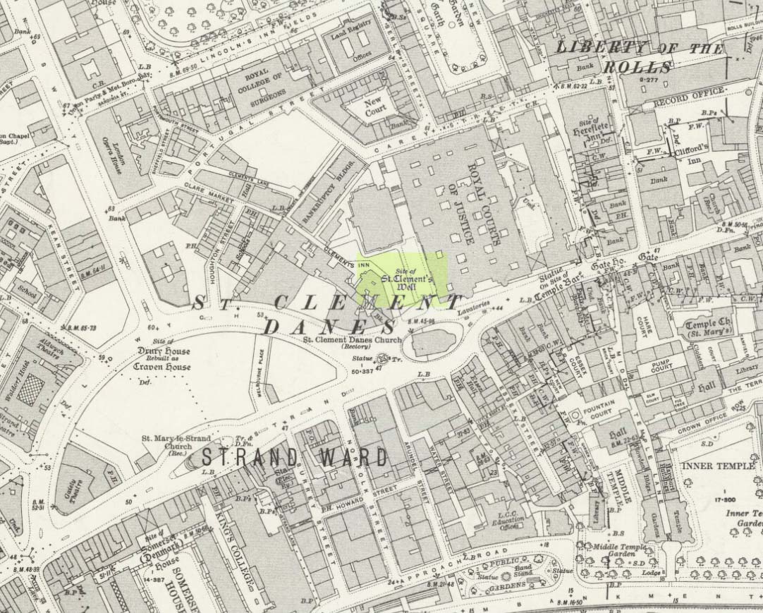
“On the Ordnance Survey Map, published in 1874, a spot is marked on the open space west of the Law Courts with the words “Site of St. Clement’s Well”: this spot is distant about 200 feet north from the Church of St. Clement Danes, and about 90 feet east of Clement’s Inn Hall, which was then standing. The Inn, with the ground attached to it, was disposed of not long after 1884, when the Society of Clement’s Inn had been disestablished.”
On the northeast side of the St. Clement’s church, a metal plaque was erected in 1807 (it’s still there!) which claims to be the position where the holy well existed. It reads:
“The well underneath, 191 feet deep, and containing 150 of water was sunk & this pump erected at the expense of the parish of St Clement Danes.”
In Mr Sunderland’s (1915) account of the Well, he told that it was located “200ft north” of the church, “covered by the Law Courts, built between 1874 and 1882”; and that although the waters here were clear and pure, they were “probably not medicinal”. Its waters, he said, fed the old Roman Spring Bath at No.5, The Strand.
In Edward Walford’s (1878) standard work, he told that,
“Round this holy well, in the early Christian era, newly-baptised converts clad in white robes were wont to assemble to commemorate Ascension Day and Whitsuntide; and in later times, after the murder of Thomas à Becket had made Canterbury the constant resort of pilgrims from all parts of England, the holy well of St. Clement was a favourite halting-place of the pious cavalcades for rest and refreshment.”
Folklore
Although I can find nothing specifically relating St. Clement’s Well with the old customs cited below, a connection seems highly likely, as the events started where Mr Foord (1910) said the holy well was located. The great english folklorist Christina Hole (1950) wrote:
“One of the most charming ceremonies in London is the Oranges and Lemons service at St. Clements Danes. It takes place every year on March 31st, or as near as possible to that date, and is a modified revival of an old custom which has only recently died out. In the lifetime of many elderly people now living, the attendants of Clements Inn used annually to visit all the residents of the Inn and present them with oranges and lemons, receiving some small gift in return. At the March service, the church is decorated with oranges and lemons, and all the children who attend are given fruit as they leave the building, while the bells play the old nursery rhyme. The oranges and lemons are supplied by the Danish colony in London, whose church this has been for many centuries, and are often distributed by Danish children wearing their national colours of red and white.”
The historian Laurence Gomme (1912) propounded that the ancient stone cross of The Strand nearby, and the Strand maypole, were elements relating to an unbroken line of heathen traditions dating back to the early Saxon period—and the customs here cited would seem to increasingly validate this. A more detailed multidisciplinary analysis of this cluster of sites along The Strand by competent occult historians is long overdue.
The Strand ley (courtesy Paul Devereux)
One final thing: if the position of the Well is indeed the one cited on the 1807 plaque, to the northeast of St. Clement’s church, then it lies bang on the ley-line that was first propounded by Alfred Watkins (1922; 1925; 1927), and subsequently enlarged upon by Devereux & Thompson! (1979)
References:
Devereux, Paul & Thomson, Ian, The Ley Hunter’s Companion, Thames & Hudson: London 1979.
Foord, Alfred Stanley, Springs, Streams and Spas of London: History and Association, T. Fisher Unwin: London 1910.
Gomme, Laurence, The Making of London, Clarendon: Oxford 1912.
Gover, J.E.B., Mawer, Allen & Stenton, F.M., The Place-Names of Middlesex, Cambridge University Press 1942.
Hole, Christina, English Custom and Usage, Batsford: London 1950.
Johnson, Walter, Byways in British Archaeology, Cambridge University Press 1912.
Street, Christopher E., London’s Ley Lines, Earthstars: London 2010.
Sunderland, Septimus, Old London Spas, Baths and Wells, John Bale: London 1915.
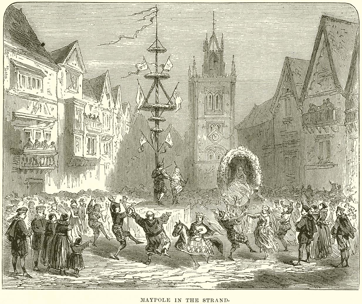
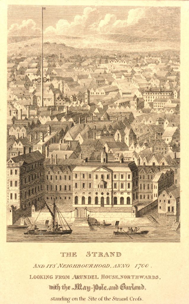
Maypole (destroyed): OS Grid Reference – TQ 3073 8092
Archaeology & History
This huge traditional monument was once a sight to behold! It stood close to where an ancient stone ‘cross’ once lived. But—alas!, with the intrusion of the incoming christians bringing a profane ‘religion’ that belongs to countries far from here, its destruction was imposed. They destroyed so many of our ancient monuments with their hatred and ignorance… But thankfully we have some good accounts of this long-forgotten relic of London’s real history.
In A.R. Wright’s (1938) account of it, he called this “the most famous maypole in England” and it stood taller than even the great maypole that’s still raised at Barwick-in-Elmet, in Yorkshire.
There seems to have been three maypoles on this same site – the first of which was standing before the destruction of Strand’s ancient cross, where local jurisdictions and early village meetings took place. We don’t know the date when the first maypole was erected, but it was shown on a local plan of the area “which Anthony van den Wyngaerde issued in 1543…in front of the old church of St. Mary le Strand, which was demolished in 1549.” According to Mr Hone (1826), it could be found a door or two westward beyond “where Catherine Street descends into the Strand.”
In Edward Walford’s (1878) massive tome, he gave us perhaps the best and most extensive account of the site, telling:
“The Maypole, to which we have already referred as formerly standing on the site of the church of St. Mary-le-Strand, was called by the Puritans one of the “last remnants of vile heathenism, round which people in holiday times used to dance, quite ignorant of its original intent and meaning.” Each May morning, as our readers are doubtless aware, it was customary to deck these poles with wreaths of flowers, round which the people danced pretty nearly the whole day. A severe blow was given to these merry-makings by the Puritans, and in 1644 a Parliamentary ordinance swept them all away, including this very famous one, which, according to old Stow, stood 100 feet high.
On the Restoration, however, a new and loftier one was set up amid much ceremony and rejoicing. From a tract printed at the time, entitled ‘The Citie’s Loyaltie Displayed,’ we learn that this Maypole was 134 feet high, and was erected upon the cost of the parishioners there adjacent, and the gracious consent of his sacred Majesty, with the illustrious Prince the Duke of York:
“This tree was a most choice and remarkable piece; ’twas made below bridge and brought in two parts up to Scotland Yard, near the king’s palace, and from thence it was conveyed, April 14, 1661, to the Strand, to be erected. It was brought with a streamer flourishing before it, drums beating all the way, and other sorts of musick. It was supposed to be so long that landsmen could not possibly raise it. Prince James, Duke of York, Lord High Admiral of England, commanded twelve seamen off aboard ship to come and officiate the business; whereupon they came, and brought their cables, pullies, and other tackling, and six great anchors. After these were brought three crowns, borne by three men bareheaded, and a streamer displaying all the way before them, drums beating and other musick playing, numerous multitudes of people thronging the streets, with great shouts and acclamations, all day long. The Maypole then being joined together and looped about with bands of iron, the crown and cane, with the king’s arms richly gilded, was placed on the head of it; a large hoop, like a balcony, was about the middle of it. Then, amid sounds of trumpets and drums, and loud cheerings, and the shouts of the people, the Maypole, ‘far more glorious, bigger, and higher than ever any one that stood before it,’ was raised upright, which highly did please the Merrie Monarch and the illustrious Prince, Duke of York; and the little children did much rejoice, and ancient people did clap their hands, saying golden days began to appear.”
A party of morris-dancers now came forward, “finely decked with purple scarfs, in their half-shirts, with a tabor and a pipe, the ancient music, and danced round about the Maypole.”
The setting up of this Maypole is said to have been the deed of a blacksmith, John Clarges, who lived hard by, and whose daughter Anne had been so fortunate in her matrimonial career as to secure for her husband no less a celebrated person than General Monk, Duke of Albemarle, in the reign of Charles II., when courtiers and princes did not always look to the highest rank for their wives.
…Newcastle Street, at the north-east corner of the church of St. Mary-le-Strand, was formerly called Maypole Alley, but early in the last century was changed to its present name, after John Holles, Duke of Newcastle, the then owner of the property, and the name has been transferred to another place not far off. At the junction of Drury Lane and Wych Street, on the north side, close to the Olympic Theatre, is a narrow court, which is now known as Maypole Alley, near which stood the forge of John Clarges, the blacksmith, alluded to above as having set up the Maypole at the time of the Restoration.
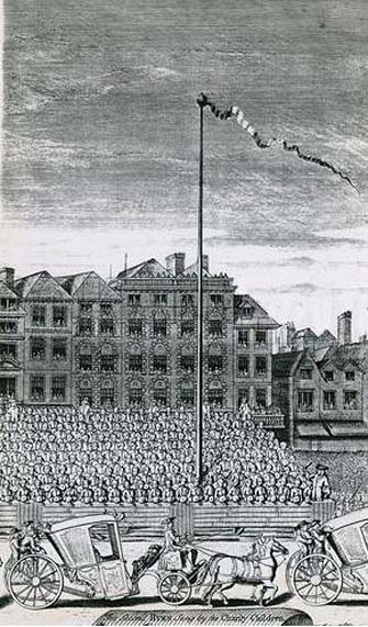
As all earthly glories are doomed in time to fade, so this gaily-bedecked Maypole, after standing for upwards of fifty years, had become so decayed in the ground, that it was deemed necessary to replace it by a new one. Accordingly, it was removed in 1713, and a new one erected in its place a little further to the west, nearly opposite to Somerset House, where now stands a drinking fountain. It was set up on the 4th of July in that year, with great joy and festivity, but it was destined to be short-lived. When this latter Maypole was taken down in its turn, Sir Isaac Newton, who lived near Leicester Fields, bought it from the parishioners, and sent it as a present to his friend, the Rev. Mr. Pound, at Wanstead in Essex, who obtained leave from his squire, Lord Castlemaine, to erect it in Wanstead Park, for the support of what then was the largest telescope in Europe, being 125 feet in length. It was constructed by Huygens, and presented by him to the Royal Society, of which he was a member. It had not long stood in the park, when one morning some amusing verses were found affixed to the Maypole, alluding to its change of position and employment. They are given by Pennant as follows:
“Once I adorned the Strand,
But now have found
My way to Pound
On Baron Newton’s land;
Where my aspiring head aloft is reared,
T’ observe the motions of th’ ethereal Lord.
Here sometimes raised a machine by my side,
Through which is seen the sparkling milky tide;
Here oft I’m scented with a balmy dew,
A pleasant blessing which the Strand ne’er knew.
There stood I only to receive abuse,
But here converted to a nobler use;
So that with me all passengers will say,
‘I’m better far than when the Pole of May.'”
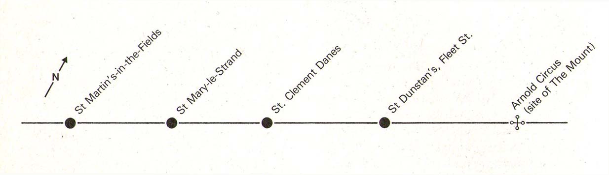
Along with the Strand Cross, this old maypole would have been on the ancient ley (not one of those ‘energy lines’ invented by New Age fantasists) that was first described first by Alfred Watkins (1925)—running from St. Martins-in-the-Field to St. Dunstan’s in Fleet Street. The alignment and maypole was subsequently described in greater detail in Devereux & Thomson’s (1979) work on the same subject, and again by Chris Street. (2010)
The nature of the maypole (and the nearby cross, it has to be said), may have been representative of an omphalos in early popular culture (before the christians of course)—which would put the original ritual function of the place far far earlier than is generally considered. This is something that Laurence Gomme (1912) propounded in one of his London works and cannot be discounted.