Ostensibly non-linear carved designs, generally assumed to be Bronze Age in date, but many originate in the neolithic period (some may indeed date back to 5000 BCE). Their central features are small rounded cup-markings, circles, semi-circles, curved lines (short, mid-length, and long), straight-ish lines, double- and multiple-rings, all in usually abstract design-forms. Their almost complete non-linear nature relate to non-egoic structuralisms, making them difficult to ‘intellectually’ grasp. Added to this is that no two carvings are the same. Although no direct ‘meaning’ can be ascribed to the carvings, many of them have a relationship with ancient notions of death and/or burial. In animistic terms, they relate to the spirit of rocks and other features of the natural landscape. They have very little relationship with alignment features (though exceptions in some megalithic rings have been found). Some modern writers allege positive relationships with water, but this ingredient (if tenable) cannot yet be said with any certainty: the idea should be forged onto animistic relationships with the land itself.
From Gelligaer, take the northernern road up Heol Adam for 2-300 yards, where you’ll see a footpath on your left taking you into the fields. Walk up the path and as it crosses the wall and bends due east, you’ll see the boulder in the middle of the field. That’s it!
Archaeology & History
Across the road from Tir-y-Rhen is this singular flat boulder, measuring about 10ft x 6ft, with at least 33 full cup-markings etched on it. Described briefly in Chris Houlder’s (1974) Welsh Archaeological guide, then more recently in John Sharkey’s (2004) Welsh rock-art book where he told there to be perhaps another seventeen cups on its surface, the Royal Commission (1976) lads gave us the surity of definition in their survey of neolithic sites in the region. A kilometre north of Gelligaer, some 260m above sea level, we find this well-preserved carved rock:
“An approximately rectangular block…much weathered at at the corners…2.6m long NE-SW, by 1.7m wide, and about 0.6m thick. The upper surface is covered with a haphazard series of 33 cup-marks varying from 40 to 115mm in diameter, and from 5 to 60mm deep… There are also 17 more cup-marks which are too weathered for precise measurement, but whose presence is certain. Other may have been completely worn away. Two more slabs of stone are just visible under the west corner of the main stone, suggesting the possibility that the cup-marks were made on the capstone of a cromlech, now collapsed.”
An earlier account by Wheeler (1925) described a number of lines or channels linking some cup-marks to each other, but these are now very difficult to see. I’ll hopefully get some decent images of this carving sometime soon!
References:
Houlder, Chris, Wales: An Archaeological Guide, Faber: London 1974.
Royal Commission on the Ancient & Historical Monuments, Wales, An Inventory of the Ancient Monuments in Glamorgan – Volume 1: Pre-Norman, Part 1: The Stone and Bronze Ages, HMSO: Cardiff 1976.
Sharkey, John, The Meeting of the Tracks, Gwas carreg gwalch: Llanwrst 2004.
Wheeler, R.E.M., Prehistoric and Roman Wales, Oxford University Press 1925.
Various ways to get here (being in the middle of the moor n’ all). I s’ppose the best way is to go from Langbar village, up hill to The Old Pike giant cairn, then follow the footpath on about 100 yards before dropping down the slope to your right, south (NOT the other way!). You’ll notice some walling and an old path near the bottom of the slope SE from you – head in that direction, but before you get there, a coupla hundred yards before, stop and look around. Good luck!
Archaeology & History
Found halfway up the southern slope beneath The Old Pike giant cairn, we find this large, flat earthfast stone, on which are the very faded remains of archetypal cup-and-ring motifs. At the top-end of the stone are slightly more pronounced cup-markings – seemingly more than is shown on the drawing, with the multiple-rings halfway along the stone. On the southeastern part of the stone, Richard Stroud found another previously unseen aspect of the carving, consisting of one large ring, with perhaps a line running out to the east. This can be seen in the water-highlighted photo.
Langbar Stone, with extra single ring not previously noted
If you visit this carving, try and get to the Middleton Moor CR-482 stone half-a-mile southwest – where I for one got the distinct impression that whoever carved that stone, also carved this one! Barmy p’raps — but if we don’t allow subjective interface here and there, we never learn a damn thing!
Listed as stone 459 in Boughey & Vickerman’s (2003) survey, they erroneously ascribe Eric Cowling to have found it in Rombald’s Way (1946), whereas the first mention of it appears to have been by Stuart Feather in 1966 (though Cowling does mention a ‘Langbar Stone’, but illustrates another one nearby).
References:
Boughey, Keith & Vickerman, E.A., Prehistoric Rock Art of the West Riding, WYAS 2003.
Cowling, Eric T., Rombald’s Way, William Walker: Otley 1946.
Feather, Stuart, ‘Mid-Wharfedale Cup-and-Ring Markings. No.41, Langbar Moor, Ilkley,’ in Bradford Cartwright Hall Archaeology Group Bulletin, 11, 1966.
From The Royalty hotel, walk along the footpath onto the Chevin itself, turning left then walk about 350 yards east, past the small copse of trees. Just north of the main path before the land slopes down you’ll find it. It’s carved on an earthfast rock about 6 feet long.
Archaeology & History
This is an excellent carving if you’re into cup-and-rings! Eric Cowling (1940) first described the stone* in an article for the Yorkshire Archaeology Society. Although it’s somewhat faded, when the stone’s wet and the sun’s low on the horizon, you can make out more rings than just the three which Boughey & Vickerman (2003) described in their survey.
Folklore
Knotties Stone (E.T. Cowling)
Although the Chevin itself has a tradition of ‘supposed’ heathen goings-on in bygone days, the carving has nothing specific said about it. Although one intriguing bit of info comes from the old Otley historian, Harold Walker (1974), who said that, “blocks of stone were sent from (the) Chevin to form the foundations of the Houses of Parliament”!
Those lying deviants probably smashed up a few bits of extra rock art when they did this — not that those sort of people give a shit about anything unless it’s about money.
References:
Boughey, Keith & Vickerman, E.A., Prehistoric Rock Art of the West Riding, WYAS 2003.
Cowling, E.T., ‘A Classification of West Yorkshire “Cup-and-Ring” Stones,’ in Archaeology Journal, 97, 1940.
Cowling, E.T., Rombald’s Way, William Walker: Otley 1946.
Hotham, John Paul, Halos and Horizons, Hotham Publishing: Leeds 2021.
Walker, Harold, This Little Town of Otley, Olicana: Otley 1974.
* Graeme Chappell tells me that this carving was named after Cowling’s nickname, Knotty!
Seemingly destroyed, this carved standing stone was first described in Shaw’s Tourist Guide to the Isle of Man (1877), where he says it stood by the wall of the chapel, telling how it was “one of several stones inscribed with various designs and inscriptions.”
Hope that I’m wrong, but it seems like we’ve lost some more good old cup-and-ring art…
Loadsa ways to get to this little outcrop, which the Boughey & Vickerman survey (2003) says comprises of five different carvings (CRs 33-37). I’m not so sure misself. When Stuart Feather first found these in the 1950s, he only thought three stones were carved, which I think is the more accurate.
Most folk would probably prefer to walk down the slope from Holden Gate down the footpath past Jaytail Farm, then dropping down to the very bottom of the fields (south) where you’ll see a small knoll with a cluster of rocks just in front of the tree-line. But I wandered up thru the ‘Private’ (ahem!) woodland, wet-thru in the pouring rain, and clambered over the wall right to the very spot (the old dowser’s ‘seek-and-find-rock-art’ nose worked again!).
Archaeology & History
High Carr Cup-Marked Stone – from Hedge’s Carved Rocks on Rombald’s Moor
Listed in John Hedge’s (1986) survey as carvings 1-5, I’d say there’s one “definite” carving here, but the others – comprising simply of cups – are a little dubious. The main carving has at least six definite cup-markings, found on the rock at the highest point of the knoll at the bottom of the field. The drawing in Hedge’s survey shows as many as 12 cups on this stone, but I’m not totally convinced. Another stone right next to the main one has, perhaps, a cup-marking or two on it – but again, these may be natural.
Of the other alleged carvings, it was difficult to work out as they were literally covered in tons of cow-shit. It seems this rock-outcrop is the local bovine toilet! A lovely secluded place though, with plenty of wildlife to see. Next stop from here: the great Holden waterfalls!
References:
Boughey, K. & Vickerman, E.A., Prehistoric Rock Art of the West Riding, WYMCC: Wakefield 2003.
Feather, S., ‘Three Bronze Age Rock Carvings near Keighley,’ in CHAGB 4:3, 1959.
Hedges, John D., The Carved Rocks on Rombald’s Moor, WYMCC: Wakefield 1986.
Cup-and-Ring Stone: OS Grid Reference – NT 499 403
Archaeology & History
The Scottish Royal Commission reported how,
“in 1936 a cup-marked boulder measuring 3ft 10in in length, 3ft 8in width and 1ft 8in in thickness, was found in a cultivated field half a mile southeast of Hawksnest and 75 yards north of the road from Hawksnest to Ladhopemoor.”
The carved stone had been scarred a little by the plough, but had “23 shallow cup-marks on its upper surface varying from 1in to 1.75in diameter.” This carving is curiously omitted from Ronald Morris’ Prehistoric Rock Art of Southern Scotland (1981), so perhaps the carving has been lost. Does anyone know owt more about it?
References:
Royal Commission on the Ancient & Historical Monuments of Scotland, Roxburghshire – volume 2, HMSO: Edinburgh 1956.
Take the road from Shipley to Guiseley, the A6038, past the turn-off to Esholt, until you get to the top of what’s locally known as Hollins Hill. There’s a small farm-track to your leftand in the woodland here you’ll find the rocky outcrop.
Archaeology & History
Nothing has been written about this spot, but in this large wind-and-water worn rock outcrop, with its small cave, on the top part of the rock are several faint cup-markings.
Folklore
Legend tells that a man on horseback jumped from the top of here and landed safely at Low Hall, Yeadon, 2500 yards away to the east. (probably some sort of solar lore)
References:
Gray, Johnnie, Through Airedale, from Goole to Malham, 1891.
In the vicinity of the denuded ring-cairn and old tumulus of Wortshorne Hill, the Calderdale historian Mr J.A. Heginbottom (1979) described finding this simple cup-marked rock, a hundred yards or so northwest of the old circle. In my ambles here I was unable to locate it. The stone may have been reburied or destroyed. Prehistoric cup-marked carvings are (officially at least) rare things in Lancashire – and usually where you find one, others lurk close by. Do any local folk out there know anything more about this site?
References:
Heginbottom, J.A., The Prehistoric Rock Art of Upper Calderdale and the Surrounding Area, YAS: Leeds 1979.
Although cited as being on Weston Moor, it is closer to Askwith village. From the village, take the north road and shortly before reaching the T-junction, park-up (somewhere!). There’s a small copse of trees on your right and fields above them – that’s where you’re heading. You might have to bimble about a bit before the rock catches your attention, but it’s worth the wandering. Look around!
Archaeology & History
Sketch of the design c.1985
This is an excellent, archetypal cup-and-ring stone that’ll be loved by any real rock art student! Cups-and-multiple rings are the main visual feature to this stone, along with another 20 single cups and another primary cup-and-ring, all on a medium-sized sloping rock face. The carving was first described by Cowling & Hartley (1937). Since their initial discovery, several other writers have mentioned it with little further comment. The smaller but impressive double cup-and-ring carving 543 can be seen at the bottom left of the woodland in front of you – well worth seeing if you’re visiting here!
References:
Boughey, Keith & Vickerman, E.A., Prehistoric Rock Art of the West Riding, West Yorkshire Archaeology Service 2003.
Cowling, Eric T., Rombald’s Way, William Walker: Otley 1946.
Cowling, E.T. & Hartley, ‘Cup-and-Ring Markings to the North of Otley,’ in Yorkshire Archaeological Journal, 33, 1937.
Hotham, John Paul, Halos and Horizons, Hotham Publishing: Leeds 2021.
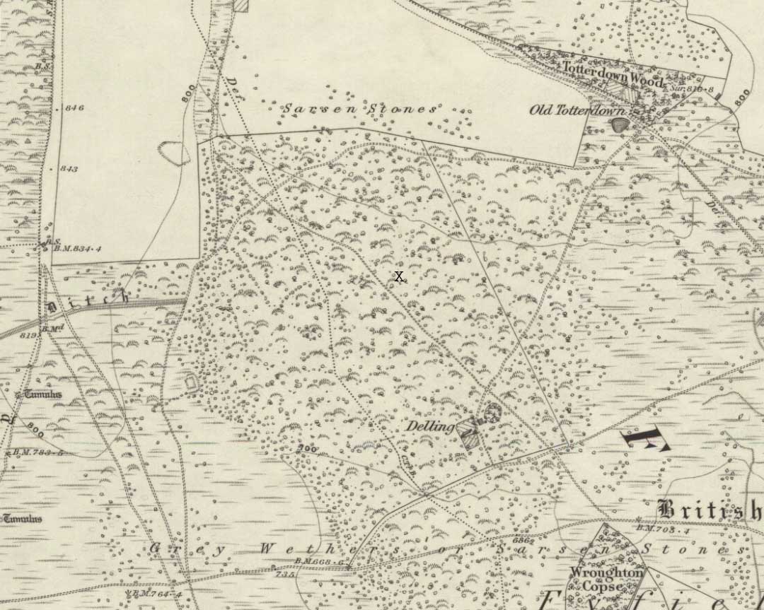
We were fortunate and taken here by the renowned local megalith authority, Pete Glastonbury – but without Pete’s help you might be ambling here and there for quite a while. It’s on the eastern side of The Ridgeway, down the slope past the stone known as The Polisher, across the flatland sea of many rocks until it begins rising again a few hundred yards east. Where a long straight embankment rises up a few feet (a boundary line), the rock’s just a few yards above it. Walk back and forth around here and you’ll eventually find it!
Archaeology & History
Lacaille’s 1962 sketch of the carving
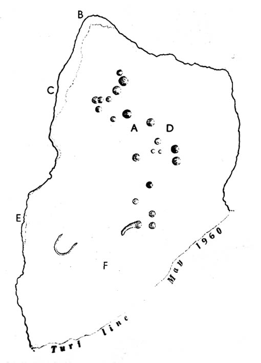
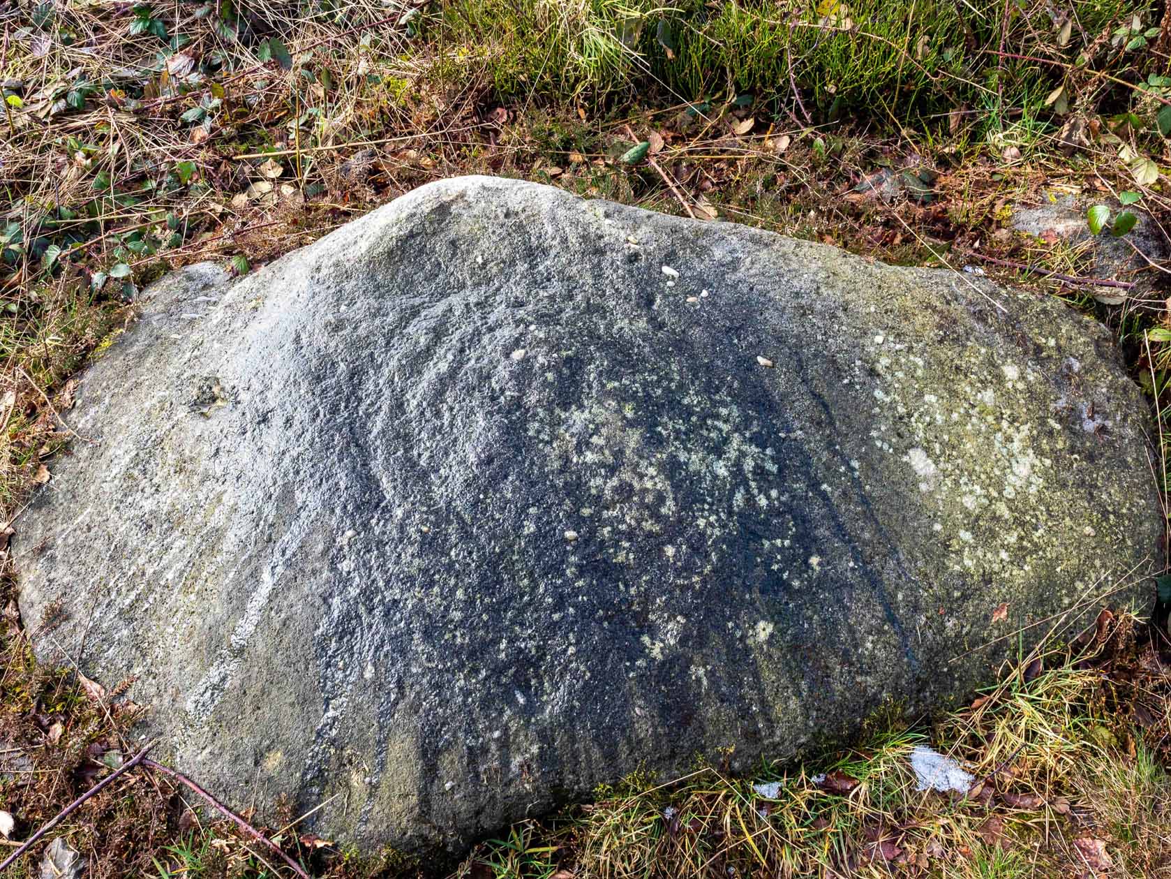
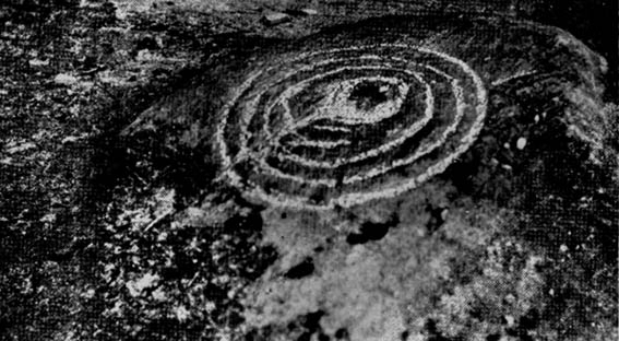
Archaeologist A.D. Lacaille (1962) appears to have been the first person to have written about this little-known site, describing it as being “between the south-western corner of Totterdown Wood and Delling Cottage.” Here is what he described as, “a cluster of unmistakably artificial and mostly well-preserved cup-markings on the smooth south-easterly sloping surface of a recumbent sarsen.”
And from the photos accompanying Lacaille’s article, it obviously looked a decent carving as well — and so it has transpired. Lacaille (1963) briefly mentioned the carving again a year later in his lengthier essay on the nearby Polisher Stone up the slope a few hundred yards away. But then Wiltshire’s only known cup-marked stone was all-but ignored by archaeologists and left in the literary wilderness until, years later when rock art became a fad in such circles, regional archaeologists Pete Fowler & Ian Blackwell (1998) described the carving as “a cluster of several round depressions…each about two inches across”; though incorrectly ascribed it as the “southernmost example” of cup-marked stones outside of Cornwall.¹ Another rock-art student known as Mr Hobson, following his excursion to the site with the regional authority Pete Glastonbury, wrote:
“The cups themselves are very smoothed out, and fit the bill from the drawing. The horseshoe is very evident, as is the ‘slug’ mark, possibly a half-finished groove from one of the cups near the horseshoe. There are also some angular, yet serpentine (?) grooves at turf level on the south side of the stone. These look like they might be enhanced natural marks in places.”
The rock itself isn’t in its original position, having been moved from another point very close by (probably only yards away). It is sited on the edge of an old boundary line — which made me wonder whether the ‘U’- or ‘C’-shaped ingredient in the carving was a later addition, perhaps of one of the old land-owners hereabouts. The cups however, seem typical of the thousands that we find in northern Britain.
The isolation of this carving is rather anomalous. Others should be in the area but archaeo-records are silent (though the majority of Wessex archaeologists are academically illiterate when it comes to identifying such carvings). The carving may simply be the product of nomadic northerners, showing what their tribes do ‘up North’, so to speak. However, considering the tough nature of southern sarsen stones, it’d have taken ages to etch just this one stone. You can visualise it quite easily: southern tribal folk looking on, somewhat perplexed, as a northern traveller tried to convey what they etch on their stones in the northern lands, only to struggle like hell with cup-marks they’d do with ease on the softer rocks of their homelands. Wessex tribes-folk may have watched, seen the trouble their traveller had over such inane and (perhaps) meaningless carvings, and didn’t see the mythic point s/he was trying to convey…
Curious ‘U’ or ‘C’-shaped feature
Or maybe not!
The lesson with rock-art tends to be simple: where there’s one carving, others are nearby. The rule aint 100% of course — but when we were here the other day I was wanting to dart here, there and everywhere to check the many thousands of outcrop rocks that scatter this entire area. Us rock-art nuts tend to do things like that. It’s a madness that afflicts…
There were one or two stones with ‘possible’ single cup-markings on them, but I wasn’t going to start adding them to any catalogues. They were far too questionable. I was wanting something a bit more decent than that. And then, when Mikki, June, Pete, Geoff and I got to the collapsed long barrow known as the Devil’s Den a few hundred yards further down this rock-strewn sea of a valley, there was something with a bit more potential that we came across…
Folklore
In recent years this cup-marked stone has already attracted imaginative notions, with little foundation. Archaeologists Fowler & Blackwell (1998), in their otherwise fine book, think this carving was related to goddess worship, describing how,
“On Dillion Down…the Great Mother’s help was permanently invoked by patiently indenting a special stone with symbols of her potency.”
Adding that this “was a new idea brought in from the North, and Fyfield was the only place to have such a stone.” Weird! I could’ve sworn there were plenty of other rocks between here and there!
References:
Fowler, Peter J., Landscape Plotted and Pieced: Landscape History and Local Archaeology in Fyfield and Overton, Society of Antiquaries London 2000.
Fowler, Peter & Blackwell, Ian, The Landscape of Lettice Sweetapple, Tempus: Stroud 1998.
Lacaille, A.D., ‘A Cup-Marked Sarsen near Marlborough, Wiltshire,’ in Archaeological Newsletter 7:6, 1962.
¹ Along with the cup-markings atop of Devil’s Den a few hundred yards to the south, across in Somerset we had the Pool Farm example; there are a number of examples in Dorset, including the Badbury Rings carving; plus others in Devon, etc.


")