To search for any sites in the northern counties of England (previously known as Brigantia), click on the list of relevant counties, below. Please note that not all these english counties were truly in Brigantia, but they came close to its southern edges; and as parts of them tickle the edges of the southern Pennines, I thought they should be included. Hope that’s OK with everyone!
Best way to find this is to get up to the Dobrudden caravan site on the edge of Baildon Hill, near the cinder-dump, then follow the same directions as for the Baildon Moor carving no.171. It’s on the same plain amidst the grasses – but you’re gonna have to zigzag about for a while before you find it!
Archaeology & History
A simple plain cup-marked stone which Boughey & Vickerman (2003) reckoned to have 14 of the little babies etched on its surface. Ninety years earlier, the reliable Mr W.P. Baildon (1913) — who seems to have been the first person to describe this carving — showed there to be 15 cups when he came here.
This was one of the many carved rocks that astronomer Gordon Holmes (1997) looked at in his attempt to give a celestial explanation for the designs. I’m not too sure misself…
References:
Boughey, Keith & Vickerman, E.A., Prehistoric Rock Art of the West Riding, WYAS 2003.
Hedges, John (ed.), The Carved Rocks on Rombalds Moor, WYMCC: Wakefield 1986.
Holmes, Gordon T., 2000 BC – A Neolithic Solstice Odyssey, SASRG Press 1997.
Go up through Baildon centre and head onto the moors. Crossing the cattle-grid, a coupla hundred yards further up, turn left. Past the small reservoirs on your left, another 100 yards or so and you reach the brow of the hill. As you begin going down the road, there’s a small car-park right by the roadside. The curious remains of the earthworks at the side of the old circle are discernible in the grassland right to its side.
Archaeology & History
Illustrated on the 6-inch OS-map of 1852 as “Site of a Barrow” (similar to how it appears in the image drawn here by Mr. C.N.M. Colls) a short distance below Pennythorn Hill top, there are still considerable traces of the earthworks surrounding the east and southern sides of what was once some form of ring cairn or tumulus that was once at this prominent place in the landscape.
Aerial view of siteThe site was first explored by Mr Colls in 1843 (his results were reported a few years later), who found a loose double-ring of stones, fifty feet across, surrounded by a shallow trench which was most notable on the south and east sides. Two urns were also uncovered near the centre of the ring, nearly two feet down, containing the cremated remains of people. A few years later, the Leeds historian James Wardell (1869) told a most fascinating note about what happened during their excavation, saying:
“This…examination was attended by a circumstance not soon to be forgotten by the persons engaged therein (on the excavation). They had almost reached the place where the broken urn and bones were deposited when, at once, such a fearful storm of thunder, lightning and rain came on, that they were not only considerably alarmed, but driven from the Common to seek shelter in the village.”
Colls’ 1846 sketch
We hear this sorta thing at many of our ancient places!
Colls 1846 plan
One anonymous writer in 1955 described the site as a ‘stone circle’, and a number of subsequent archaeologists copied this without question; but in all probability this site was more typical of an old cairn circle or ring-cairn, similar in size and design to the Roms Law circle two miles north of here. However, the earthworks at its side give the impression of some sort of exaggerated hengiform enclosure.
The place-name element howe strongly indicates a burial site and is a suffix found at many prehistoric tombs across northern England. The prefix ‘acre’ may relate to “a plot of arable or cultivated land, a measure of land (an acre) which a yoke of oxen could plough in a day” (Smith 1956), or may be a corrupted form of the Old English word, ‘acen’, relating to oak trees. Early literary examples of the place-name would enable a clearer understanding of the prefix element here.
References:
Anonymous, Colls’ Burial Mound Stone Circle, Baildon Moor, Museum Leaflets: Bradford 1955.
Baildon, W. Paley, Baildon and the Baildons (parts 1-15), St. Catherines: Adelphi 1913-26.
Barnes, Bernard, Man and the Changing Landscape, Eaton: Merseyside 1982.
Bennett, Paul, The Old Stones of Elmet, Capall Bann: Milverton 2001.
Colls, J.N.M., ‘Letter upon some Early Remains Discovered in Yorkshire,’ in Archaeologia, 31, 1846.
Collyer, Robert & Turner, J.H., Ilkley: Ancient and Modern, William Walker: Otley 1885.
Smith, A.H., English Place-Name Elements – volume 1, Cambridge University Press 1956.
Wardell, James, Historical Notes of Ilkley, Rombald’s Moor, Baildon Common, and other Matters of the British and Roman Periods, Joseph Dodgson: Leeds 1869. (2nd edition 1881)
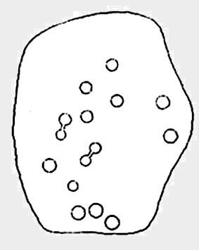
If you wanna find this carving, you’ll find it near several others on the Low Plain, 40 yards east of the footpath north of Dobrudden Farm. Look around in the tribbly grass!
Archaeology & History
This was first described and illustrated in a short article by William Glossop in the Bradford Antiquary in 1888, and reproduced by W. Paley Baildon (1913) – who drew his own impression of the carving. Tis one of my favourites from this moor. Dunno why – I just like it.
W.P. Baildon’s accurate 1913 drawingCowling’s 1946 drawing
Local astronomer and writer Gordon Holmes (1997) posited the theory that a part of this carving represented the constellation of Cassiopeia — hence its title! He told of finding the same pattern of cups at four other carvings on the moors and assigned astronomical meanings to them. He may be right, though I doubt it to be honest. Having looked and looked at the many carvings here, and many other places, the star-reflection hypothesis doesn’t tend to work (as the heavenly bodies have moved somewhat since the days when the cups were first carved). Along with this, when I was young I used to think cup-and-rings did have an astronomical basis — only to find, after constant analysis, that the theory didn’t work.
There are perhaps 20 cup-markings here, with various linking-lines and curves between and around the cups. Perhaps the most accurate of the early drawings was Mr Paley Baildon’s 1913 image, where he highlighted the faint surrounding ring enclosing the 4 or 5 cups near the bottom of the stone.
References:
Boughey, Keith & Vickerman, E.A., Prehistoric Rock Art of the West Riding, WYAS 2003.
Cowling, Eric T., Rombald’s Way, William Walker: Otley 1946.
Glossop, William, “Ancient British Remains on Baildon Moor,” in Bradford Antiquary, 1888.
Hedges, John (ed.), The Carved Rocks on Rombalds Moor, WYMCC: Wakefield 1986.
Holmes, Gordon T., 2000 BC – A Neolithic Odyssey, SASRG Press 1997.
From East Morton village, take the moorland road, east, and up the steep hill. Where the road levels out there’s a left turn where a trackway leads onto the moor. Go up here & keep walking till you hit a moorland ‘footpath’ signpost. Stop here and walk due west (your left) onto the gently sloping rise and into the mass of the Stanbury Hill enclosure system. Keep walking for 200 yards or so, where the land begins to slope down to the end of the spur; and just 50 yards before it drops down to the stream below you’ll find a cluster of carved rocks like the Lunar Stone, the Teaspoon Rock, Spotted Stone, etc, all scattered about. Near these, you’ll find this one!
Archaeology & History
Not to be confused with the carving of the same name on the northern side of these moors (near the Green Crag Slack enclosure), this carved rock gets its name specifically from looking like a lay-out plan of some settlement or enclosure. It’s unlikely that this title or description has anything to do with the carving, but its the impression it gave me when I first saw it! But then once you look at the carving from another angle it takes on a different impression.
Enclosure Carving from above
First thought to have been found by Stuart Feather in 1978, it is one of many carvings that occur in what seems to be an extensive prehistoric enclosure or settlement. There’s a complete cup-and-ring near the western end of the rock, with another distinct cup-marking by its side, and what looks to be a natural cup at the top-end of the stone. But it was the other section of the carving on the central and eastern side which intrigued me: a curious ‘enclosure’ of lines, with a cup-marking in each section. Cutting between the cup-and-ring and the enclosure lines is a natural long crack or fissure running roughly north-south through the rock. It seemed to me (though I could be wrong) that a line had been pecked running along this natural crack — although in Boughey & Vickerman’s (2003) drawing they don’t highlight this. It also seemed that the carved lines from ‘enclosure’ linked up to the pecked line that was carved along the natural fissure in the rock (as illustrated in my crap drawing!).
Shit drawing of CR99
As with the Lunar Stone nearby: it appears that either this stone was carved at different periods; or else for a long period of time much of the stone was exposed to the elements, whilst a section of it remained covered. For the distinct cup-and-ring on the western-end is more worn, with more eroded evidence of pecking, than the extended lines on the eastern end of the rock. I need to go back here and get some better images — and certainly do a much better drawing!
References:
Boughey, Keith & Vickerman, E.A., Prehistoric Rock Art of the West Riding, WYAS 2003.
Hedges, John (ed.), The Carved Rocks on Rombalds Moor, WYMCC: Wakefield 1986.
Dead easy! Avoiding Keighley (as common sense dictates), but going to its outskirts, get to the huge Cliffe Castle (tis free) on the northern outskirts of the town. Go inside and look around!
Archaeology & History
Carving in Cliffe Castle MuseumClose-up of cups & rings
Initially located in the ground a few yards south of Dobrudden caravan park amidst a large gathering of other carved rocks, this grand-looking cup-and-ring stone is no longer in situ. As with a several other carvings, this has been on a bittova wander in the last century! It was first uprooted from the Earth and archaeologically transferred to Bradford’s Cartwright Hall Museum sometime after World War 2, where it lived peacefully for a number of years, before being moved to Cliff Castle Museum, where it still lives, quietly (along with another prehistoric carved rock, the Comet Stone, that was nabbed from the uplands near the Roms Law circle).
Baildon’s 1913 drawing
As we can see from the photos (taken in poor lighting in the museum – sorry…) there are five cup-and-rings with one cup-and-2-rings standing out (plus about another 10-12 cups scattered here and there); though when W. Paley Baildon drew a picture of the stone around 1913, he could clearly see another cup-and-ring etched onto the stone, but this has faded somewhat in the last century. Messrs Boughey & Vickerman (2003) were unable to see it.
References:
Baildon, W. Paley, Baildon and the Baildons – parts 1-15, Adelphi: London 1913-1926.
Boughey, Keith & Vickerman, E.A., Prehistoric Rock Art of the West Riding, WYAS: Leeds 2003.
Hedges, John, The Carved Rocks on Rombald’s Moor, WYMCC: Wakefield 1986.
Jackson, Sidney, ‘Cup and Ring Boulders of Baildon Moor,’ in Bradford’s Cartwright Hall Archaeology Group Bulletin, 1, 1955.
This is a lovely-looking stone in the pictures and diagrams, and is quite easy to find close to the meeting of the footpaths along Foldshaw Ridge and the Parks Lane track, near the gate. It lays at an angle in the short grass just by the path…but to me, all is not what it seems…
Archaeology & History
This was a carving I saw pictures of in the 1970s, and always thought it would be something to behold – but my first impression here wasn’t just disappointment, but the most distinct thought that the carving’s modern! It’s a real oddity. For a start, the cups in this carving are very small – much smaller than the countless authentic carvings on the moors here and at Ilkley to the south. And after seeing thousands of these things, this one didn’t seem at all right.
The lack of erosion on the cups may be due to it once accompanying a prehistoric tomb some time in the past, though no such remains have been noted here. However, at carved stones Middleton Moor 001 and Middleton Moor 2 — less than 100 yards to the east — cairns are in evidence next to the petroglyphs, indicating that this relationship occurs at some cup-and-ring stones in this small geographical region and, perhaps, explaining the ideosyncratic nature of this design.
But such speculation aside – the brief literary history of this stone is: first described by Stuart Feather in 1965 and illustrated by Sidney Jackson the same year. The rock art students Boughey & Vickerman’s (2003) described around sixty ‘cups’ etched onto the stone here, but they made no comment about either the odd nature of the cups or the possibility of it being modern. Perhaps it’s just me…
References:
Boughey, Keith & Vickerman, E.A., Prehistoric Rock Art of the West Riding, West Yorkshire Archaeology Service 2003.
From Bakewell take the A6 Matlock road, follow this till just past the signs for Haddon Hall where you take a right (the first major junction) for Youlgreave the B5056. After about 1km take the first left over the bridge. You then take the first right turn: a steep lane with restriction signs (don’t worry there’s access for cars but no wide vehicles). Take the first left you come to by the barn and then just follow the road, up through the woodland where the lane narrows then shortly after you’ll see Robin Hood’s Stride to your left. Park a little way after the field gateway and look across the field to your left. The stones are visible from the road.
Archaeology & History
This is a fine-looking ring of stones — though perhaps the word ‘ring’ is slightly misleading here, as only four of (apparently) nine originals still remain and they are, by definition, more in a square-shape than a circle! But it’s a lovely site. When Geoff brought us here for the first time only last weekend, despite the dark clouds and cold grey day, along with the fact that we’d been sleeping rough the night before and got soaking wet through, there was a subtle feel to this place which my shivering senses still touched. Only just though…!
Two southernmost stones
Mebbe it was the rising crags of Robin Hood’s Stride to its immediate south? Or the quietly hidden companionship with other stones and sites in the locale? I don’t really think so. There was something a little more about its own genius loci that tingled very slightly on the rise in the field upon which the circle sits. Some people would, perhaps, acquaint my sense of a subtle genius loci here to the various leys or ley-lines that have been drawn through here by other writers— but it wasn’t that.
When earlier writers came here, they too had various inspirations of differing forms. John Barnatt’s (1978) early impressions of the place had him signing astronomical events in and around the remaining stones here, despite knowing that the site had been damaged. In later years he revised his early notions — as most of us do as our perspectives are enriched — but the astronomy is still assumed here. As Clive Ruggles (1999) told:
“Other rings are located where natural features coincide with astronomical events, such as Nine Stone Close in Derbyshire…from which the Moon at the southern major standstill limit, sets behind the gritstone crag of Robin Hood’s Stride to the SSW, between ‘two stubbly piles of boulders jutting up at either end of its flat top.'”
Major Rooke’s drawing of the Nine Stones Circle, c.1780
The stones that remain here are quite tall, between 6½ and 8 feet tall. One of them seems to have originally been taken from a stream or river-bed. They stand upon the small rise in the field and has diameters of 40 and 45 feet respectively. Aubrey Burl described there being seven uprights still here in 1847, and the early drawing of the site near the end of the 18th century by Major Hayman Rooke highlights 6 stones around the spot where the circle now stands. In J.P. Heathcote’s (1947) summary, he wrote that,
“Bateman, in his Vestiges, says an excavation in 1847 yielded some indications of interments in the form of ‘several fragments of imperfectly-baked pottery, accompanied by flint both in a natural and calcined state.’ In 1877, Llewellyn Jewitt and Canon Greenwell…turned their attention…to the Nine Stones. They dug at the foot of the second highest stone and the Canon directed a good deal of digging within the circle, but nothing special turned up. The area in the circle is now quite level, but it is probable that there was, as Bateman says, a tumulus in the centre.”
This latter remark is the impression I got of the place. Tis a really good little site. All around here are a number of other sites: cup-marked stones, enclosures or settlements, prehistoric trackways, and more.
Folklore
One of the old names of this site was The Grey Ladies. This came from the well known tale found at other sites across the world, that some ladies were dancing here at some late hour and were turned into stone. A variation on this theme told how Robin Hood stood on the nearby rock outcrop to the south and pissed over the landscape here, “where seven maidens upon seeing it turned to stone.” In this case, Robin Hood replaced an older, forgotten account of a giant, who forged the landscape and the sites around Harthill Moor.
Another tale — whose origins and nature are allied to that of the petrification of the Grey Ladies — narrated with considerable sincerity by local people, was that the circle was a place where the little people gathered and where, at certain times of the year, “fairy music and the sight of hundreds of dancing shapes around the stones” would happen.
Said by Rickman and Nown (1977) to be “Derbyshire’s most magical ancient site,” they thought the site was on a ley that linked up with Arbor Lowe, less than 5 miles west, crossing a couple of tumuli on its way.
References:
Barnatt, John, Stone Circles of the Peak, Turnstone: London 1978.
Burl, Aubrey, A Guide to the Stone Circles of Britain, Ireland and Brittany, Yale University Press 1995.
Clarke, David, Ghosts and Legends of the Peak, Jarrold: Norwich 1991.
Heathcote, J. Percy, Birchover – Its Prehistoric and Druidical Remains, Wilfrid Edwards: Chesterfield 1947.
Rickman, Philip & Nown, Graham, Mysterious Derbyshire, Dalesman: Clapham 1977.
Ruggles, Clive, Astronomy in Prehistoric Britain and Ireland, Yale University Press 1999.
Thom, A., Thom, A.S. & Burl, Aubrey, Megalithic Rings, BAR: Oxford 1980.
Taking the roughly north-south road betwixt the village of Elton and the town of Youlgrave, rising up to see the great rock outcrop of Robin Hood’s Stride, park-up by the roadside and walk down the path across the fields to the Nine Stone Close stone circle. Once at the circle, look at the wall immediately south of here (looking towards the great Robin Hood’s Stride rock towers) about 100 yards away and you’ll see a large, nicely-worn ‘standing stone’ in the walling, with another a few yards to its side.
Archaeology & History
Nine Stones monolith, with stone circle behind
It seems like there’s been quite a lot written of this particular stone — much of it deeming, or speculating, that it once had summat to do with the stone circle of Nine Stones Close (which you can see in the background on one of the photos). The local archaeologist and writer, J. Percy Heathcote (1947) told us that around 1819, a Mr Glover said that this stone and a companion stood next to each other, but Mr Heathcote thought that,
“Judging from its size alone, only one of these is large enough to be compared to the stones in the circle.”
Standing Stone and Robin Hood’s Stride in background
Heathcote continued:
“Dr Phillips apparently assumes this stone to be connected with the circle in the same way as the similarly placed King Stone was connected with the Nine Ladies (Stanton Moor). However, it seems more reasonable to suppose that the stone was brought by a farmer into the wall and not that he built the wall up to the standing stone.”
In more modern times however, John Barnatt (1978) thought that this stone was originally in the circle, but “has been moved across the field to the south to act as a gatepost.”
It’d be hugely improbable that it didn’t have summat to do with the stone circle, but exactly what, we can only speculate.
References:
Barnatt, John, Stone Circles of the Peak, Turnstone: London 1978.
Heathcote, J. Percy, Birchover – Its Prehistoric and Druidical Remains, Wilfrid Edwards: Chesterfield 1947.
Taking the roughly north-south road betwixt the village of Elton and the town of Youlgrave, rising up to see the great rock outcrop of Robin Hood’s Stride, park-up by the roadside and walk down the path across the fields to the Nine Stone Close stone circle. Once at the circle, the walling closest to the stones runs along a bit (north), then downhill. Follow it. About 25 yards before hitting more walling that crosses your path, there’s a break in the wall to a field immediately left. Just below this gate opening, in the same wall, a few yards down, look for the stone!
Archaeology & History
This small carved stone, typical of the size you get in drystone walls all over the country, was discovered for the first time on November 29, 2009, by Geoff Watson, during an ambling foray exploring the megalithic sites in and around the Birchover district. Not quite sure how his nose picked this little fella out, but once seen (and eyes adjusted!) it was obviously a portable cup-marked stone. Though what, we first wondered, was it doing in the walling here?
Similar in size and form to the Bent Head cup-marked stone found in drystone walling near Todmorden, West Yorkshire, the proximity of the Nine Stone Close megalithic ring further up the slope from this example illustrated that prehistoric man found this location of some importance; but as the cup-markings — two definites, perhaps a third — had been etched onto a small portable rock, typical of those found in prehistoric tombs, we wondered whether or not a prehistoric grave had once stood close by. Thankfully, a persual of Barry Marsden’s (1977) catalogue later proved fruitful. For in the adjacent field below where this carved stone sits in its wall, at SK 2255 6286, there’s a scattered mass of loose rocks and smaller stones (akin to the one here with its cup-markings), which Marsden listed as a prehistoric tomb. It seems probable that this cup-marked ‘portable’ originally came from this much denuded burial spot.
Likelihood is — there’ll be more of ’em hiding in walling and elsewhere hereby…
NB – Please note – the images we took of the stone aint too good as the sky was grey, cloudy and overcast all day. We await a better visit on a finer day, when conditions allow for better images. As we all know, gerrin’ decent photos of cup-markings and their ilk can be a pain in the arse even on the best of days!
References:
Heathcote, J. Percy, Birchover – Its Prehistoric and Druidical Remains, Wilfrid Edwards: Chesterfield 1947. (see MegaDread’s comment, below)
Marsden, Barry, The Burial Mounds of Derbyshire, privately printed: Bingley 1977.
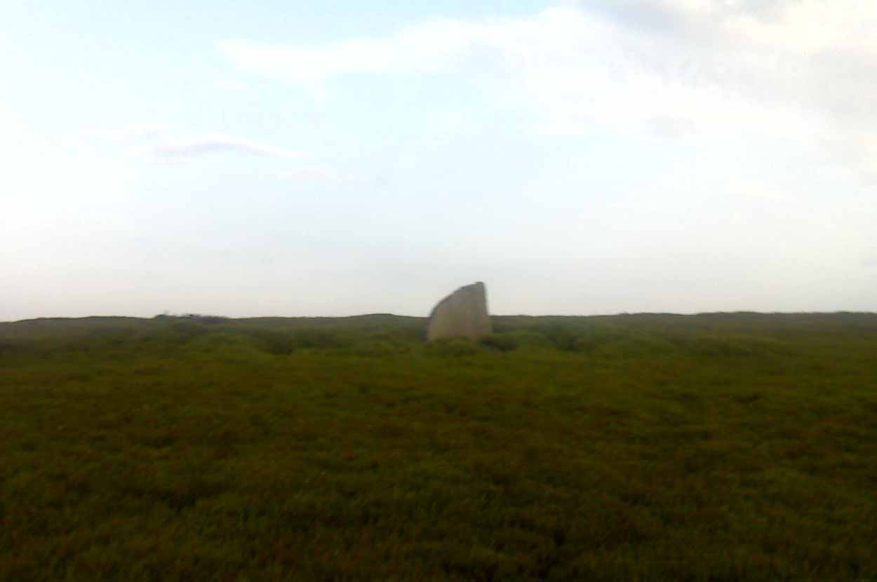
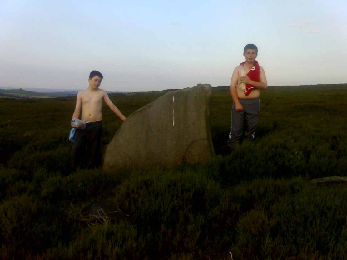
From Redmires Road, follow the path on the opposite side of the road from the reservoirs that follows the “conduit”: a man-made dyke marked on the map at SK 2601 8578. You’ll need to follow this for about 1km till you come to a junction with a path crossing a small bridge on your left, and a path to your right onto the moor. You need to take the latter for about 200 metres downhill. The standing stone is roughly 100 metres onto the moor in a NNE direction.
Archaeology and History
New Hagg, with kids for scale
None that I know of! I didn’t know of its existence until I found it whilst wandering the moor one day. Though I can find no record of it anywhere, the weathering on its top in comparison with other authentic standing stones suggest that it’s been stood for a very long time and probably since prehistory.
Four feet tall, the stone stands roughly half a kilometre SSE from the Headstone which can be seen from here – and roughly half a kilometre from the Reddicar Clough Long Cist, ESE of here.


")

")


")


")