To search for any sites in the northern counties of England (previously known as Brigantia), click on the list of relevant counties, below. Please note that not all these english counties were truly in Brigantia, but they came close to its southern edges; and as parts of them tickle the edges of the southern Pennines, I thought they should be included. Hope that’s OK with everyone!
Just below Black Hill in the Middleton Moor Enclosure, little more than 10 yards east of the footpath on the east side of Loftshaw Gill, the slope drops down and into a slight ‘bowl’ in the landscape. Here it is!
Archaeology & History
This is a previously undiscovered prehistoric settlement, enclosure, or something along those lines! We came across it in April 2005 and is found amidst the mixed heather and bracken and has a scattering of small stones, as if in the wake of a dried stream from bygone times. But whatever stream might once have been here, it’s long since fallen back to Earth — but at a point where a few rushes (Juncus conglomeratus) can be seen we find the aged remains of a large oval enclosure.
Similar in form to the other remains located up here by Eric Cowling (1946) in the 1930s and ’40s, when Richard Stroud and I first found this, structural remains of distinct lengths of walling were visible – but once the vegetation started growing back here again, it was almost impossible to discern.
Faint remains of enclosure walling
The main archaeological remains comprises of an oval-shaped structure, with what seemed liked a distinct Bronze Age note stamped on the walling — though it could be earlier, but without excavation it’s impossible to say. Most of the walling was just above ground-level, making it difficult to appreciate in the photo. It measures approximately 40 feet north-south and 33 feet east-west. The walling itself averages between 18-24 inches wide and was no more than one-foot tall at the highest. Near the middle of the enclosure there were further sections of walling indicating different ‘rooms’ in the overall structure of things here.
Like I say, we unfortunately couldn’t get a decent image of this site cos the vegetation was already covering it up. So if you wanna see it, gerrup there soon after the heather burning’s been done here — otherwise it’s gonna be at least another year before you getta chance to see anything. In Richard Stroud’s photo here, you’re looking at the bottom curve of the enclosure. You can just make out the line of walling near the centre of the picture, and two-thirds the way to the right you can see the enclosure wall curve closer to the bottom of the photo. (the site obviously requires a much better assessment from someone far more competent than me!)
References:
Cowling, E.T., Rombald’s Way, William Walker: Otley 1946.
From the little hamlet of Langbar, head up to the steep footpath to Beamsley Beacon and from there along the footpath get yourself between the giant cairn known as The Old Pike and Round Hill. About halfway between these two points the moor levels out (with brilliant views in all directions) and 200 yards southeast of the upright boundary stone, this well-defined carved rock is just a few yards north off the footpath. It seems to be just over the boundary line of Middleton Moor and onto the Beamsley Moor side (not that you give a shit when you’re up here ambling about – but the cartographers like to get things right I s’ppose!).
Archaeology & History
…and from another angleSketch of the design
Near the very top of the moor this one — this is a small carving that I rediscovered in March 2005, much of it covered in peat and heather. It’s very similar to some of the central designs found on the Baildon Moor cup-and-ring carvings, with four cup-markings (3 are deep) in a slight arc to the southern edge of this small, squared stone, very much like carvings 126 and 130 in the Boughey & Vickerman (2003) survey. However, unlike the Baildon Moor examples, no burials seem to accompany this carving—although the surrounding heather may be hiding other archaeological remains.
References:
Boughey, Keith & Vickerman, E.A., Prehistoric Rock Art of the West Riding, WYAS 2003.
Follow the same directions to reach the Middleton Moor carvings, numbers 436 and 437, up along the footpath. This is the easiest to find as it’s right beside the footpath – as Richard Stroud’s photograph clearly shows.
Archaeology & History
Drawing of CR-435Middleton Moor CR-435
Near a cluster of other cup-and-ring marked rocks, this decent example can be found besides what may be a prehistoric trackway running roughly east-west over the Long Ridge to Foldshaw Ridge. Amazingly, this stone was never previously catalogued until Boughey & Vickerman’s survey in 2003. Just goes to show what y’ can find if y’ gerrof yer arses and look for yerselves! Comprising at least thirty cups and several lines, one faint cup-and-ring is discernible on the western edge of the stone.
If you walk westwards, back up to the hilltop from here (only a couple of hundred yards), a single upright stone which some might consider megalithic, stands right before your eyes! An excellent spot!
References:
Boughey, Keith & Vickerman, E.A., Prehistoric Rock Art of the West Riding, WYAS 2003.
Follow the same directions to get to the Middleton Moor Carving 437, along the Ridge Way footpath, and this stone is just a few yards away.
Archaeology & History
This all-but insignificant carving was first described in Boughey & Vickerman’s (2003) survey, as a “small rough grit rock sloping into turf” with what may be two faint cup-markings etched on its surface. Unless you’re a bittova rock-art fanatic, this might not be of much interest to you! (thanks to Richard Stroud for use of his photo!)
References:
Boughey, Keith & Vickerman, E.A., Prehistoric Rock Art of the West Riding, WYAS 2003.
Head for the gorgeous little hamlet of Langbar, a few miles northwest of Ilkley. Less than ½-mile before the village, keep your eyes out for the footpath bearing east onto the moors at Moor End Farm (right-hand side of road if you’ve travelled from Ilkley). Walk along the Long Ridge footpath to where the fields on your left finish and the moorland proper opens up. Hereabouts, check the stones in the heather to your right! If you amble about looking, you’ll find it!
Archaeology & History
Crap drawing of CR-437
This is another one of those carvings for the purists amongst you. Less than ten yards off the footpath on Long Ridge is this medium-sized rock with several cup-marks, and lines, on both its top and vertical faces. Boughey & Vickerman (2003) think there to be at least five cups on the top, with perhaps nine on the vertical east face, though some of these are debatable. (the drawing I’ve done is from their book)
References:
Boughey, Keith & Vickerman, E.A., Prehistoric Rock Art of the West Riding, WYAS 2003.
Dead easy this. From Otley, take the north road over the River Wharfe and turn left following the signs to Askwith, where you’ll hit Weston village first. Once here, take the small left turn down to Weston Hall and the accompanying church. Go into the churchyard and check the graves!
Archaeology & History
This is a real curiosity. It’s found in the graveyard of All Saints church, Weston, where one of the graves has several small stones on it, with this small stone with the following cup-and-ring designs upon it. A plaque has been attached to it as a memorial to one ‘Susan Mary Dawson’. Strange…
Sid Jackson’s 1958 sketchCup-marked stone deliberately placed on a christian grave
It was first written about by Sidney Jackson (1957), but where it first came from and why it has been placed here in a christian setting is something of a mystery. It’s also odd inasmuch as although we know that there was some form of ritual or geomantic use of cup-and-rings in relation to neolithic and Bronze Age burials — that such a tradition has been performed by this particular family on this grave. It is obviously highly unlikely that this family had any knowledge whatsoever of burial traditions in relation to cup-and-ring art (please, shoot me down in flames if you know otherwise), so this re-use of this prehistoric stone is likely to be little other than fortuitous. But then, the occult history of some of the influential families in and around this region in relation to witchcraft, ancient kingship and esoteric practices, might indicate otherwise…
Does anyone know anything about the Dawson family history which might throw light on this modern use of a prehistoric tomb marker? It has all the hallmarks of once coming from a prehistoric cairn, but we know little of its history prior to 1957.
References:
Boughey, Keith & Vickerman, E.A., Prehistoric Rock Art of the West Riding, WYAS 2003.
Jackson, Sidney, ‘Cup-and-Ring Boulder, Weston Churchyard,’ in Cartwright Hall Archaeology Group Bulletin, 2:16, 1957.
Very troublesome to locate when the heather’s deep. To get here take the Askwith Moor Road heading north and park-up at the big gritted parking spot halfway along. Cross the road (west) and walk up a little and onto the moorland track. When you hit the triangulation pillar, walk down (left) onto the moor, heading for the small rise in the land a few hundred yards away. Once there, start walking down its sloping south-face, watching for any evidence after 100 yards. Be vigilant!
Archaeology & History
One of 4 hut circles in very good state of preservation
This small settlement was first found on 18 July, 2004, when a small group of us, in search of the troublesome Man Stone carving, were lucky to be on the moors shortly after the heather had been burnt back, amidst this archaeologically rich area of Askwith Moor, on the northern end of Hollin Tree Hill.
There were at least four hut circles found here (on the right of the track as you walk up the slope), with one in particular — the northernmost of the group — in a very good state of preservation. This particular circle measured approximately 20 feet in diameter, with an entrance to the south side. It is marked by a low earthfast boulder on the northeast side, visible even when the heather is deep.
Although we counted four such circles, it’s very likely that an intensive search would uncover more remains on this hillside. In revisiting this site in October 2016, the heather had grown back over the entire complex and the circles were very difficult to see; but we were able to discern the one on the very top of the hill (the one in the photo). The other hut circles, lower down the slopes, were notable only by zigzagging back and forth until we walked onto loose walling.
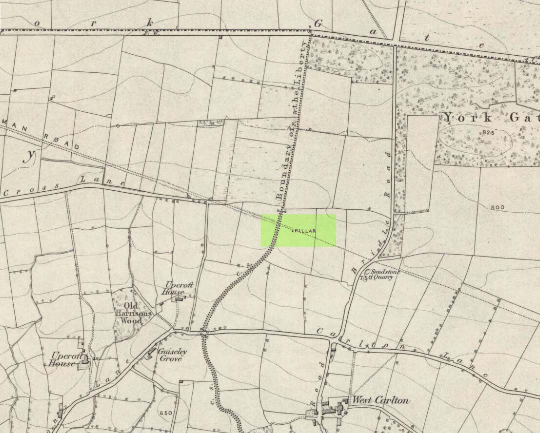
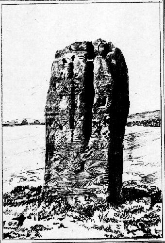
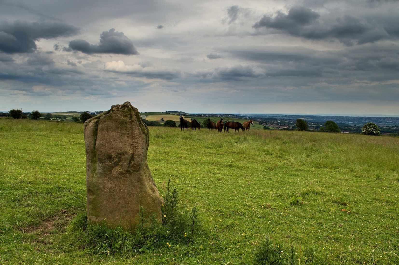
Worth checking this if you aint seen it before! Head up to the back (south-side) of Otley Chevin (where the cup-and-ring Knotties Stone lies sleeping), following the road there and park up near/at the Royalty pub. Take the footpath behind the pub which crosses the fields and once into the second field, head diagonally down to the far-left corner. From here, look over the wall — you can’t really miss it!
Archaeology & History
An intriguing site for various reasons. All we have left to see of any value nowadays is this nigh-on 6-foot tall thick monolith, standing alone in the field halfway between West Carlton and Otley Chevin. Completely missed in local archaeological surveys, the place was mentioned briefly by Slater (1880); though it appears to have been first described in detail by Eric Cowling (1946), who suspected the stone may have Roman origins (though didn’t seem too convinced!), saying that:
“near the ground the section is almost oblong, with sides three-feet six-inches by one-foot ten-inches; two feet from top, the section is almost circular.”
The fact that the stone stands very close to the line of an all-but forgotten Roman road that runs right past it added weight to this thought (the road runs towards a Roman settlement a mile east of here near Yeadon). But this standing stone is unlikely to be Roman. More recent evidence seems to indicate a relationship with a now-lost giant cairn about 100 yards to the south. The only remains we have of this place are scatterings of many small loose stones nearby. And it seems a very distinct possibility that the extra standing stones that were once hereby, stood in a line.
The very first reference I’ve found about this site also indicates that there was more than one stone here in the past! In 1720 this site was known as the ‘Boon Stones’; and the plural was still being used by the time the 1840 Tithe Awards called them the ‘Boul Stones.’ Initially it was thought that both words were plural for “bulls” — as A.H. Smith (1962) propounds in his otherwise superb survey — but this is questionable. (see Folklore)
Folklore
A piece of folklore that seems to have been described first by Philemon Slater (1880) relates to the pastime of bull-baiting here, that is –
“fastening bulls to it when they were baited by dogs, a custom…still known to the Carlton farmers” (North Yorkshire).
Cowling (1946) told that he heard the stone was said to be lucky as well as being a source of fertility. This ‘fertility’ motif may relate to the meaning of the stone’s early name, the Boon Stones. Both boon and boul are all-but obsolete northern dialect words. ‘Boul’ is interesting in its association with a prominent folklore character, as it was used as a contemptuous term “for an old man.” Now whether we can relate this boul to the notion of the ‘Old Man’ in British folklore, i.e., the devil, or satan — as with the lost standing stone of The Old Man of Snowden, north of Otley — is difficult to say.
More interestingly perhaps is the word ‘boon’, as it is an old dialect word for “a band of reapers, shearers, or turf-cutters.” This band of reapers ordinarily consisted of five or six people and would collect the harvest at old harvest times. And as the early description talks of Boon Stones, this plurality would make sense. One curious, though not unsurprising folklore relic relating to these boons was described at another megalithic site (now gone) by John Brand (1908), where in the parish of Mousewald in Dumfries,
“The inhabitants can now laugh at the superstition and credulity of their ancestors, who, it is said, could swallow down the absurd nonsense of ‘a boon of shearers,’ i.e., reapers being turned into large grey stones on account of their kemping, i.e., striving.”
Standing stones with the folklore of them being men or women turned to stone is common all over the world. If we accept the dialect word ‘boon’ as the first name of this old stone, there may once have been some harvest-time events occurred here long ago (and this is quite likely). Equally however, we must also take on the possibility that this Bull Stone has always been a loner and that its name came from the now obsolete Yorkshire word, a bull-steann, meaning a stone used for sharpening tools, or a whetstone.
Take your pick!
References:
Bennett, Paul, The Old Stones of Elmet, Capall Bann: Milverton 2001.
Brand, John, Observations on the Popular Antiquities of Great Britain – volume 2, George Bell: London 1908.
Cowling, Eric T., Rombald’s Way, William Walker: Otley 1946.
Jackson, Sidney, ‘The Bull Stone,’ in Cartwright Hall Archaeology Group Bulletin, 2:5, 1956.
Smith, A.H., English Place-Name Elements – 2 volumes, Cambridge University Press 1956.
Smith, A.H., The Place-Names of the West Riding of Yorkshire – volume 7, Cambridge University Press 1962.
Slater, Philemon, The History of the Ancient Parish of Guiseley, William Walker: Otley 1880.
As with many of the other Baildon Moor carvings, get up to Dobrudden caravan park and walk into the grasses immedietaly northeast onto the Dobrudden necropolis plain for 100 yards or so. It’s not far from the track and one of the many bell-pits is very close by. Look around!
Archaeology & History
A lovely little carving (sad aren’t I…?), first recorded and illustrated in Glossop’s (1888) famous essay on the ancient sites of Baildon Moor. He described there being 18 cups etched onto this rock — a fact echoed a few decades later in Mr Baildon’s (1913) magnum opus. The modern surveys thankfully still count 18 cups here.
Mr Baildon’s 1913 imageGlossop’s 1888 drawing
This is another one of the Baildon Moor carved stones included in Mr Holmes’ (1997) astronomical survey, where he thought the cup-markings here represented stellar maps and other prehistoric astronomical events. A damn good investigative notion, but it sadly aint true. However, those self-same ‘central design’ curves found at a large proportion of other carvings on and around Baildon Moor are plain here for all to see…
References:
Baildon, W. Paley, Baildon and the Baildons (parts 1-15), St. Catherines Press: Adelphi 1913-26.
Boughey, K.J.S. & Vickerman, E.A., Prehistoric Rock Art of the West Riding, WYAS: Leeds 2003.
Colls, J.N.M., ‘Letter upon some Early Remains Discovered in Yorkshire,’ in Archaeologia, 31, 1846.
Cowling, Eric T., Rombald’s Way, William Walker: Otley 1946.
Cudworth, William, ‘Baildon Moor & its Antiquities,’ in Bradford Antiquary 3, 1900.
Glossop, William, ‘Ancient British Remains on Baildon Moor,’ in Bradford Antiquary No.1, 1888.
Hedges, John (ed.), The Carved Rocks of Rombald’s Moor, WYMCC: Wakefield 1986.
Holmes, Gordon, 2000 BC – A Neolithic Solstice Odyssey, SASRG 1997.
Takes a bitta finding this one, mainly cos it’s only a small stone – but worth the walkabout. It’s on the Low Plain, north of Dobrudden, about 10 yards down the path from the caravan park.
Archaeology & History
W.P. Baildon’s 1913 drawing
As with other stones on this roughland plain, it was first recorded and drawn by the local historian W. Paley Baildon (1913), who counted at least 15 cups here, with one complete cup-and-ring. Some of the cups have very distinct half-rings upon them; whilst others are connected by faint lines (as his drawing clearly shows). The later surveys of Hedges (1986), and Boughey & Vickerman (2003) counted 17 cups on this stone. This was another of the carvings which local astronomer Gordon Holmes (1997) thought may have been based on the constellation of Cassiopeia (like the nearby Cassiopeia Stone, found on the same moorland plain).
References:
Baildon, W. Paley, Baildon and the Baildons (parts 1-15), St. Catherines: Adelphi 1913-26.
Boughey, Keith & Vickerman, E.A., Prehistoric Rock Art of the West Riding, WYAS 2003.
Glossop, William, ‘Ancient British Remains on Baildon Moor,’ in Bradford Antiquary, 1888.
Hedges, John (ed.), The Carved Rocks on Rombalds Moor, WYMCC: Wakefield 1986.
Holmes, Gordon T., 2000 BC – A Neolithic Solstice Odyssey, SASRG Press 1997.


")


")
