Windy Hill Circle, Baildon Moor, West Yorkshire

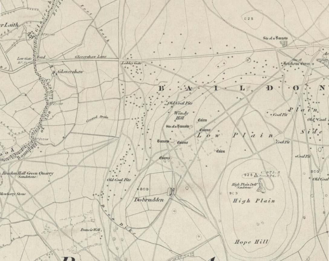
Stone Circle (destroyed):  OS Grid Reference – SE 138 403

Windy Hill on 1852 map

Archaeology & History

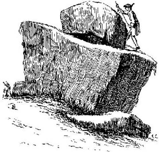
The early northern antiquarian, J.N.M. Colls (1846), described visiting a ‘druidical circle’ of stones due east of the Dobrudden prehistoric graveyard, but it seems to have been completely destroyed soon after he wrote his essay, with the stones taken away for use in road-building.  He told that here was,

“a double circle of stones, the outer ring numbering eighteen, with six stones making up the inner circle.”

…and his illustration shows just that!  It’s possible that this inner ring may have covered a burial.  Harry Speight — aka, ‘Johnnie Gray’ (1891) — is the only other writer I’ve found that refers to the megalithic remains up here, although he gave no additional details.

Windy Hill Circle (after Colls, 1846)

The site was to be found across the High Plain and Windy Hill, on the western edge of Baildon Hill, where there was once a greater profusion of seemingly neolithic and Bronze Age remains.  Another possible early reference to the site is in Collyer & Turner’s Ilkley (1885), where they talk of a circle “on the highest part of the eastern moor,” fifty-six feet across with a similar appearance to the Pennythorn Hill circle, although they describe it as overlooking the hamlet of Sconce, which is hardly possible from the Windy Hill side of Baildon Moor.

The site looked across the horizon from south, through west to north and if used astronomically would have been used to observe sun and moonset times.  Although we find a number of cup-and-ring stones in the vicinity, it really does seem that this site has bit the dust!

References:

  1. Bennett, Paul, The Old Stones of Elmet, Capall Bann: Chieveley 2001.
  2. Colls, J.N.M., ‘Letter upon some Early Remains Discovered in Yorkshire,’ in Archaeologia 31, 1846.
  3. Collyer, Robert & Turner, J. Horsfall, Ilkley, Ancient and Modern, William Walker: Otley 1885.
  4. Gray, Johnnie, Through Airedale, from Goole to Malham, Elliot Stock: London 1891.

© Paul Bennett, The Northern Antiquarian


Walton Head, Kirkby Overblow, North Yorkshire

Standing Stone:  OS Grid Reference – SE 30335 49907

Getting Here

Along the A61 Harrogate-to-Harewood road, just below the roundabout where the A658 links up, is a small country road that turns towards the lovely village of Kirkby Overblow.  If you’re in a car, park up wherever you can hereabouts (being careful of the locals!).  Cross over onto the western-side of the A61 and walk along the small tree-lined field-edge until you find a spot to get over, where this stone stands.

Archaeology & History

It’s hard to suss out how many monoliths first stood here, but when William Grainge (1871) and Harry Speight (1903) described them, it was believed they had been uprooted in the 17th or 18th century.  Although one of them has gone, thankfully the scarred remnant of one is still here.

Site number 168 in Old Stones of Elmet, one of the two standing stones that were described in parish boundary records of 1577 as “two stones standing in Walton Head Layne” can be found northeast of the village, along the ancient church way between Rigton and Kirkby.  However, it is not as it once was! The boundary perambulation was redefined in 1767, when it was thought that a new monolith had been erected to replace the site of the old ones; but it turns out that some masons simply smoothed off the old stone and carved ‘K.F. 1767’ onto one of the original two. If you look at the base of the stone (which is more than 4 feet tall, leaning slightly to one side), it’s obvious that it’s been in the ground for one helluva long time. Much much longer than any old 1767 – or 1577 for that matter!  What we appear to have here is simply a worked remnant of a true prehistoric standing stone.

References:

  1. Grainge, William, The History and Topography of Harrogate and the Forest of Knaresborough, John Russell Smith: London 1871.
  2. Speight, Harry, Kirkby Overblow and District, Elliott Stock: London 1903.

© Paul Bennett, The Northern Antiquarian


The Great Stone, Downham, Lancashire

Legendary Rock:  OS Grid Reference – SD 78212 44402

Also Known as:

  1. Downham Cross (Byrne 1974)

Getting Here

The best way to locate this is probably by starting from the pub opposite the old church of St. Leonard and heading west along the village road, past three large gate-entrances, until reaching the conspicuous milestone by the road junction.  On the other side of the road, just before the gate entrance to Downham Hall, edged into the base of the wall, we find this ‘ere The Great Stone.

Archaeology & History

The Great Stone, Downham

What a truly beautiful little village we find in Downham, nestled quietly and with age at the northern edge of Pendle hill.  It’s tucked away, off any main road so maintaining its sense of age and almost reclusive nature.  There is hidden history a-plenty scattering the landscape here, but tales of our Great Stone — thought by some as an old monolith; remains of a Roman milestone by others; whilst some just denote it as nowt but a small stone — is what brought me here.  It’s name betrayed my expectation (I always hope for too much it seems…), but the small pock-marked stone has been embedded in its present position for at least 150 years, as the growth of soil and tree behind it shows.  Archaeo-historians say little of it (reputations y’ know!) until something substantial is found; but thankfully we came upon the lovely couple who are Lord and Lady Clitheroe of Downham Hall, who told us more…

Folklore

“There are a couple of humourous legends told of the Great Stone,” Lord Downham began… But to a (sometimes) courteous megalithomaniac like myself, the tales rang the all-too-familiar bell.

Close-up of the Great Stone

The original position of the stone, though not known for certain, was some short distance away either across the road, or further along in a nearby field.  When it was moved – Lord Downham said around 1830 – the remains of a body were found beneath it; but another source told in fact that it marked “the final resting place of two legionaries who died on the nearby Roman road during trouble with the Brigantes.” (An old Roman road is nearby)  But apparently this old stone also moves. When the church bell strikes midnight the stone is said to turn itself around upside-down. Where have we heard that before!?

The site is described in Clifford Byrne’s (1974) unpublished manuscript on the crosses of Lancashire, where he cites it as being the remains of a cross pedestal, but adds that “if ever a cross stood by the village green, no memory of seems now to exist.”  But Mr Byrne also described the all-too-familiar heathen folk tales, saying:

“A local man told the writer that the object is called Downham Stone and that it turns over every night at midnight.  We read elsewhere that the boulder is called “the great stone of Downham” and that it turns at the stroke of midnight by the church clock.”

References:

  1. Byrne, Clifford H., “A Survey of the Ancient Wayside Crosses in North East Lancashire,” unpublished manuscript, 1974.
  2. Lofthouse, Jessica, Three Rivers, Robert Hale: London 1946.
  3. Lofthouse, North Country Folklore, Robert Hale: London 1976.
  4. Winterbottom, Vera, The Devil in Lancashire, Cloister: Stockport 1963.

© Paul Bennett, The Northern Antiquarian


Toscaig, Applecross, Ross & Cromarty

Standing Stones: OS Grid Reference – NG 715 384

Archaeology & History

The Cambridge biologist J. Havelock Fidler described finding three standing stones in the gorgeous little remote hamlet of Toscaig in his book Ley Lines (1983), which neither the Applecross Local History Society, myself, nor anyone else has been able to locate (the OS grid reference cited above is simply an approximation of their locality). In an updated version of his work, Mr Fidler seems to indicate they can be found a short distance south-east of the village, at the end of an alignment which is supposed to start at Fearnmore (NG 724 605), at the northern edge of the peninsula. If they exist, could anyone perhaps enlighten us as to their whereabouts…?

References:

  1. Fidler, J. Havelock, Ley Lines – Their Nature and Property, Aquarian: Wellingborough 1983.

© Paul Bennett, The Northern Antiquarian


Sowerby Lad, Mytholmroyd, West Yorkshire

Standing Stone (destroyed): OS Grid Reference – SE 024 244

Archaeology & History

Standing stone on 1894 map

Also known as the Field House Standing Stone, this monolith seems to have gone.  It was first described in local Minister’s Accounts of 1403, and then again in the Wakefield court-rolls of 1515.  By the time John Watson (1775) wrote about the place there had been several other references describing this old “standyngstone”. It was still upright in 1852, but Ordnance Survey showed it as “Site of – ” at the beginning of the 20th century, and the stone had been moved a short distance away, further down from its original position to a spot at the side of the old trackway — but all trace of it has since vanished.

Folklore

This is thought to have been the standing stone which Robin Hood threw here, from the appropriately called Robin Hood’s Penny Stone at Wainstalls. The tale tells how he dug it out of the ground with a spade and threw it three-and-half miles across the valley until it landed here. Ooh, what a strong boy!

References:

  1. Bennett, Paul, The Old Stones of Elmet, Capall Bann: Milverton 2001.
  2. Smith, A.H., The Place-Names of the West Riding of Yorkshire, volume 3, Cambridge University Press 1961.
  3. Watson, John, The History and Antiquities of the Parish of Halifax, T. Lowndes: London 1775.

© Paul Bennett, The Northern Antiquarian


Roms Hill, Wadsworth, Hebden Bridge, West Yorkshire

Standing Stone:  OS Grid Reference – SE 0080 3261

Getting Here

Roms Hill Stone

Whether coming from Hebden Bridge or Oxenhope: at the very top of the long uphill road, at the very top where a small radio station sits by the roadside (the views from here are effing superb!) – stop! On the opposite side of the road from the radio station, get over the fence (I think there’s a gate nearby) and walk roughly westwards down the gently inclining grassland slope.  Keep westward-ish for about 200 yards (if that) and you’re damn close!

Archaeology & History

Rediscovered in January 2002, this is a very curious stone, over a metre in height, isolated on the southern edge of Roms Hill, close to the folklore-sounding Halfpenny Hole Clough, near the very top of the hill between Hebden Bridge and Oxenhope. The base of the stone is almost wedged into a space between two rocks and its positioning here seems quite deliberate.  It stands upon a small geological ridge in the ground that stretches for some distance, east and west, either side of here.

Roms Hill Stone in good fog!

Despite this, it seems unlikely to have an authentic prehistoric pedigree, but as there’s little else been said of the stone (apart from Dave Shepherd’s (2003) article on local megalithic remains, many of which are highly dubious as archaeological remains), it deserves a mention here.  It’s not recorded in any of the old boundary records — unlike the upright boundary stone that can be found a few hundred yards northwest of here on the same moorland plain.

The land here has an etymological relationship with the Roms Law (or Grubstones) Circle on Rombald’s Moor, but as yet we can ascertain little more about this site.  Well worth a visit — if only for the superb views it affords!

References:

  1. Shepherd, David, “Prehistoric Activity in the Central Pennines,” in Transactions of the Halifax Antiquarian Society, volume 11 New Series, 2003.

© Paul Bennett, The Northern Antiquarian


Robin Hood’s Penny Stone, Wainstalls, West Yorkshire

Stone Circle (destroyed):  OS Grid Reference – SE 046 288

Archaeology & History

The Pennystone on 1852 map

All remains of this site, first mentioned as a stone circle in 1836, have gone. The place could be found by the appropriately named Stone Farm at the top end of Wainstalls and was first mentioned by John Watson (1775), who strangely said nothing about any circle here.  However, this changed when John Crabtree (1836) arrived and described a ring of stones surrounding a large boulder in the centre (illustrated here). The boulder itself was actually called the Robin Hood Penny Stone.

Folklore

Watson's 1775 drawing
Watson’s 1775 drawing

This was one of the many legendary sites from where our legendary outlaw practiced shooting his arrows.  He was also said to have picked up and thrown a large standing stone from this spot, until it landed three-and-a-half miles away on the hillside on the other side of the Calder Valley. (this was known as the Field House, or Sowerby Lad Standing Stone)

References:

  1. Bennett, Paul, The Old Stones of Elmet, Capall Bann 2001.
  2. Crabtree, John, Concise History of the Parish and Vicarage of Halifax, Hartley & Walker: Halifax 1836.
  3. Dobson, R.B. & Taylor, J., Rymes of Robyn Hood, Alan Sutton: Gloucester 1989.
  4. Faull, M.L. & Moorhouse, S.A., West Yorkshire: An Archaeological Guide (4 volumes), WYMCC: Wakefield 1981.
  5. Varley, Raymond, “A Stone-Axe Hammer, Robin Hood’s Penny Stone and Stone Circle at Wainstalls, Warley, near Halifax,” in Yorks. Arch. Journal 69, 1997.
  6. Watson, John, The History and Antiquities of the Parish of Halifax, T. Lowndes: London 1775.

© Paul Bennett, The Northern Antiquarian


Rocking Stone, Rishworth Moor, West Yorkshire

Legendary Rock:  OS Grid Reference – SD 990 150

Archaeology & History

Rishworth Moor Rocking Stone, 1775

The reverend John Watson (1775) first wrote about this place, describing it as, “a group of stones, laid, seemingly, one above another, to the height of several yards, and called the Rocking stone.”  Very little archaeological remains have been described hereabouts, save the odd flint scatters here and there.  Anything which might have been here in the past was likely destroyed when the M62 was built right next to the site.

Folklore

The rocking stone was long ascribed in local tradition to be a  site used by the druids.  It was said that in bygone days the great boulder would rock, but this must have been a long time ago as even when Mr Watson described it, he told how “that quality is lost.”

Close by is the sometimes dried-up spring known as the Booth Dean Spa, which Watson thought might have been related to whatever ancient rituals occurred here.

References:

  1. Watson, John, The History and Antiquities of the Parish of Halifax, T.Lowndes: London 1775.

© Paul Bennett, The Northern Antiquarian


Ringstones, Lowgill, Lancashire

Stone Circle (destroyed): OS Grid Reference – SD 664 655

Archaeology & History

I have found no archaeological references whatsoever to this site (though to be honest, the Lancashire archaeological fraternity are pretty poor when it comes to finding and recording sites).  The place has its existence preserved in the aptly-named Ringstones Lane and the farmhouse, Ringstones.

Michala Potts found several records of the place in the 17th century, and the site is shown on the 1844 OS-map with the same name, but we have been unable to ascertain when/if any standing stones were here.  The place may well have been a burial-site of some sort, as found at other Ringstone place-names in Lancashire.  But we can clearly see on aerial imagery that there is a large, distinct, circular outline in the heavily ploughed fields about 100 yards north of the farm.  There is what may be the remains of a second circle above this, but the outline is faint; but it appears that an enclosure of some sort, ovoid in shape and a couple of hundred feet across, was also evident in the same field where the more distinct circular outline is seen.

My favourite outline however, is a large linear mark on the ground stretching for several hundred yards running roughly north-south, starting in the field between Aikengill and Ringstones and going dead straight, bypassing the circle and crossing Ringstones Lane, where it seems to disappear and is no longer visible.  The curious ‘ground line’ is roughly 100 feet across.  Cursus anyone!?

© Paul Bennett, The Northern Antiquarian

Wart Stone, Bradford, West Yorkshire

Standing Stone (destroyed):  OS Grid Reference – SE 15940 34211

Also known as:

  1. Ash Stone
  2. Pin Stone

Archaeology & History

Wart Stone on 1852 OS-map

At Bradford City’s football ground there used to be the holy well known as the Holy Ash Well, adjacent to which was this old stone (as shown on the 1852 OS map).  For some reason it was uprooted and moved further up the hill around the end of the 19th century and was resurrected beside the old Belle Vue Hotel on Manningham Lane.  From thereon however, I’ve not been able to trace what happened to it, and presume it’s been destroyed.  It was known by local people to have had a ritual relationship with the adjacent healing well, to which people were said to visit from far and wide.

It seems to have been described first by Abraham Holroyd (1873), who told us that:

“In Manningham Lane there is a fine well, in old deeds called Hellywell, i.e., holy well, in a field now called Halliwell Ash, now a stone quarry… Near this is the ancient Pin Stone.”

The Bradford historian William Preston also made mention of the stone in one of his early surveys, where he told how local people also knew the stone as the Ash Stone, due to its proximity and ritual relationship to a great old tree.

Folklore

Also known as the Wart Stone, thanks to its ability to cure them and other skin afflictions.  Intriguingly, the building which now stands on the site is said to be haunted.

As my old school-mate, Dave Pendleton (1997), said of the place and its associated well:

“Prior to 1886 the only feature of any real note in the Valley Parade environs was a holy well that emerged near the corner of the football grounds Midland Road and Bradford End stands; hence the road Holywell Ash Lane. Today the site of the well is covered by the football pitch.

Only the road name survives as a reminder of what was apparently one of the district’s foremost attractions. On Sundays and holidays people would gather to take the waters and leave pins, coins, rags and food as offerings to the spirit that resided in the waters.

Accounts suggest that the well was covered and had a great ash tree standing over it (hence ‘holy ash’). There was also a standing stone called the wart stone of unknown antiquity. The stone had a carved depression that collected water. It was believed that the water was a miraculous cure for warts. Indeed, as early as 1638 the Holy Well had been credited with healing powers.

The well suffered a decline in popularity during the late nineteenth century and its keepers resorted to importing sulphur water from Harrogate, which they sold for a half penny per cup. The well disappeared under the Valley Parade pitch during the summer of 1886 and the wart stone was moved to the top of Holywell Ash Lane – which then ran straight up to Manningham Lane. The stone was still there as late as 1911 but thereafter it seems to have disappeared into the mists of time.”

Unfortunately we have no old photos or drawings of this lost standing stone – though I imagine that some local, somewhere must be able to help us out with this one.  Surely there’s summat hiding away…

References:

  1. Bennett, Paul, The Old Stones of Elmet, Capall Bann: Milverton 2001.
  2. Holroyd, Abraham, Collecteana Bradfordiana, Saltaire 1873.
  3. Pendleton, David & Dewhirst, John, Along the Midland Road, Bradford City AFC 1997.

© Paul Bennett, The Northern Antiquarian