Jinny Well, Newchurch-in-Pendle, Lancashire

Sacred Well:  OS Grid Reference – SD 82377 39458

Getting Here

Easy to locate: it’s just by the roadside on the left-hand side of the road, Jinny Lane, coming out of the village, just after the last house where the field begins.

Archaeology & History

Nowt to write home about, as they say.  The waters here trickle from the earth into an old stone trough — but they don’t look too appetizing (even I didn’t have a drink, which is something of a rarity!).  Its the folktale accompanying this little site, giving a distinct hint of some heathen past, that I found intriguing.

Folklore

Here was once the spirit of a woman called Jinny – who gave her name to the road it’s on – that wandered betwixt the well and an old stone, once found further up the hillside (after a bitta digging, we found the remains of the old stone, previously an authentic monolith). It was said that if you wandered along the road on certain moonlit nights, her spirit would chase you. To make matters worse, the ghost was a headless one!

Jinny’s spirit originally resided, peacefully, in the broken old stone atop of the hill. At a certain time of the year, the spirit of the stone would venture downhill to drink from the waters here (much as we find at Rollright and other places). But one day a xtian priest came along and, because of its heathen association, broke the old stone in half and cursed the spirit which roamed between the sites. Thereafter, Jinny’s ghost wandered in torment, with her head hacked off, scaring people half to death when they saw her. And so, another priest was eventually called who, to the satisfaction of local people, eventually put Jinny’s ghost to rest, as they say. It seems to have been a successful ritual, as no-one has reporting seeing the headless ghost for many a long year.

References:

  1. Byrne, Clifford H., Newchurch-in-Pendle: Folklore, Fact and Fiction, Marsden Antiquarians: Nelson 1982.

© Paul Bennett, The Northern Antiquarian


Ring Hill, Littlebury, Essex

Hillfort:  OS Grid Reference – TL 515 382

Also Known as:

Getting Here

You can’t really miss this.  Roughly halfway along the B1383 London Road between Littlebury and Wendens Ambo, just above Chestnut Avenue, a dirttrack on the west-side of the road takes you up and onto the wooded hillside. Where the track splits in two, head straightforward up and into the trees until it opens into the clearing. You’re there!

Archaeology & History

This great monument had already been described several times before the Domesday Book had even been thought about!  Indeed, it seems that the town itself gets its name from the hillfort! (Reaney 1935)  Nowadays the place is just about overgrown and covered in woodland.  You cna make out various undulations where parts of the ditches are apparent, but it could do with a clean-out.  Thought to be Iron Age, Nick Thomas (1977) described the site as,

“Oval in plan, this fort follows the contour of the hill it encloses, protecting about 16½ acres… the defences consist of a bank, ditch and counterscarp bank, of which only the ditch is well-preserved.”

References:

  1. Reaney, Paul, The Place-Names of Essex, Cambridge University Press 1935.
  2. Thomas, Nicholas, Guide to Prehistoric England, Batsford: London 1977.

Links:

  1. Ring Hill, Littlebury

© Paul Bennett, The Northern Antiquarian

North Ring, Mucking, Stanford-le-Hope, Essex

Enclosure (destroyed):  OS Grid Reference – TQ 675 811

Archaeology & History

North Ring, Mucking (after Brown, 2001)

This large circular enclosure, measuring about 120 feet across, seemed to be a small settlement with several internal structures (fences, pits, cremations and a sunken-floored structure) that was first excavated in 1978 and described as a Bronze Age enclosure.  Akin to a henge monument in some ways, this small settlement site had two entrances: one on the east and the other opposite on its west side.  However, the main ‘entrance’ was on the eastern (sunrise) side, where post-holes laid a pathway over the ditch and into the structure itself.

The excavation on the eastern side of site revealed two periods of construction with associated structures, including three circular buildings.  Some excavations to the east produced evidence for a range of contemporary activities.  The assemblage of Late Bronze Age material included pottery, metalwork, cremation remains, sickle moulds and equipment for salt production.  For further info and imagery, see the Link below.

References:

  1. Bond, Dermot, Excavation at the North Ring, Mucking, Essex, East Anglian Archaeology 1988.
  2. Brown, N., “The Late Bronze Age Enclosure at Springfield Lyons in its Landscape Context,” in Essex Archaeology & History, volume 32, 2001.

Links

  1. North Ring, Mucking

© Paul Bennett, The Northern Antiquarian

Springfield Lyons, Chelmsford, Essex

Enclosure:  OS Grid Reference – TL 7357 0818

Archaeology & History

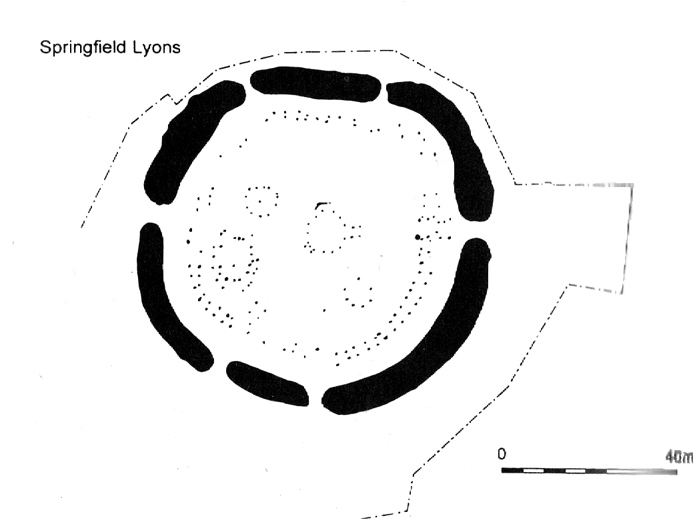
Springfield Lyons enclosure (after Brown, 2001)

We’ve known that there was an excessive number of prehistoric archaeological sites in and around the Chelmsford region for quite a long time now, but defining precisely the age and nature of the finds takes some doing! (as you’d expect)  It hasn’t helped, of course, with the housing estates and other ecologically destructive building operations in and around the area, screwing up a more accurate and patient assessment of the material there.  And this predicament was exemplified with the Springfield Lyons neolithic causewayed enclosure just as much as at the Springfield Cursus and other sites nearby.

Although excavations here found a large, deep ditch with impressive ramparts and entrance, in Oswald, Dyer & Barber’s (2001) survey of these giant monuments, they defined the remains here as “probable,” pending further investigations.  But the site was primarily defined by the large deep ditch, broken in several places round its edges with the ’causeways’ built leading onto the site.  The enclosure gave good views over the small valley from here and had streams running either side of it.

Adjacent to the site were the remains of a “small circular enclosure with multiple entrances,” saying that excavation here,

“has proved that it is of late Bronze Age date and might be interepreted variously as a defended settlement, or a ritual monument.”

This external small enclosure site was then conjectured, quite spuriously it’s gotta be said, to be a mini-version of the great causewayed enclosure monument, saying:

“Its siting and form both hint that it could have been a conscious imitation of, or re-invention of, the perceived form of the earthworks of the neolithic enclosure.”

I like the idea, it’s gotta be said — but without direct evidence we’ve gotta take this idea with a large pinch of salt!

…to be continued…

References:

  1. Brown, N., ‘The Archaeology of Essex 1500 – 500 BC,’ in Bedwin, O. (ed.), The Archaeology of Essex, ECC: Chelmsford 1996.
  2. Brown, N., “The Late Bronze Age Enclosure at Springfield Lyons in its Landscape Context,” in Essex Archaeology & History, volume 32, 2001.
  3. Oswald, Alastair, Dyer, Caroline & Barber, Martyn, The Creation of Monuments: Neolithic Causewayed Enclosures in the British Isles, EH: Swindon 2001.
  4. Priddy, D., ‘Excavations in Essex, 1987,’ in Essex Archaeology & History, 19, 1988.

© Paul Bennett, The Northern Antiquarian


St. Helen’s Well, Colne, Lancashire

Holy Well:  OS Grid Reference – SD 890 397

Getting Here

This site can be reached with relative ease from Colne’s train station by crossing the road and going up Bridge Street, turning immediately left along Shaw Street for several hundred yards until you reach Waterside Road on your left-hand side.  From here, as Mr Tom Sharples told, “St. Helen’s Well is presently within the area of overgrown and unmanaged scrub woodland adjacent to Waterside Road.”  Look around!

Archaeology & History

First described on the Megalithic Portal by the pseudonymous Brionnfhionn, this recently rediscovered holy well can be found on the southern side of Colne, at Waterside.  A few months after the MegPortal announcement, a more detailed overview of the site was published on GoogleDocs, from where Mr Tom Sharples has kindly allowed us to repeat the information that both he and Susan Bryant-Lauder compiled there.

The site was relocated after reference had been found in Geoff Crambie’s (1978) A Colne Festival, where he wrote:

“1935 saw the end of St. Helen’s Mill in Waterside.  Built by Nicholas England in 1835, it was named after the St. Helen’s Well nearby, which was reputed to have been named by the Romans.”

The local writer Dorothy Harrison (1988) also mentioned the site, though only in passing, when she told,

“Along with St. Helen’s Well, Buck Spout provided the main source of drinking water in Waterside.”

There has to be some more information about this little-known site hidden in some old Lancastrian history or folklore work, somewhere – surely!?

References:

  1. Crambie, Geoff, A Colne Festival, Turner & Earnshaw: 1978.
  2. Harrison, Dorothy (ed.), The History of Colne, Pendle Heritage Centre 1988.

© Paul Bennett, The Northern Antiquarian

Split Rock, Rivock, Keighley, West Yorkshire

Cup-and-Ring Stone:  OS Grid Reference – SE 07989 44208

Also Known as:

  1. Carving no.39 (Hedges)
  2. Carving no.80 (Boughey & Vickerman)

Getting Here

Split Rock, Rivock
Split Rock, Rivock

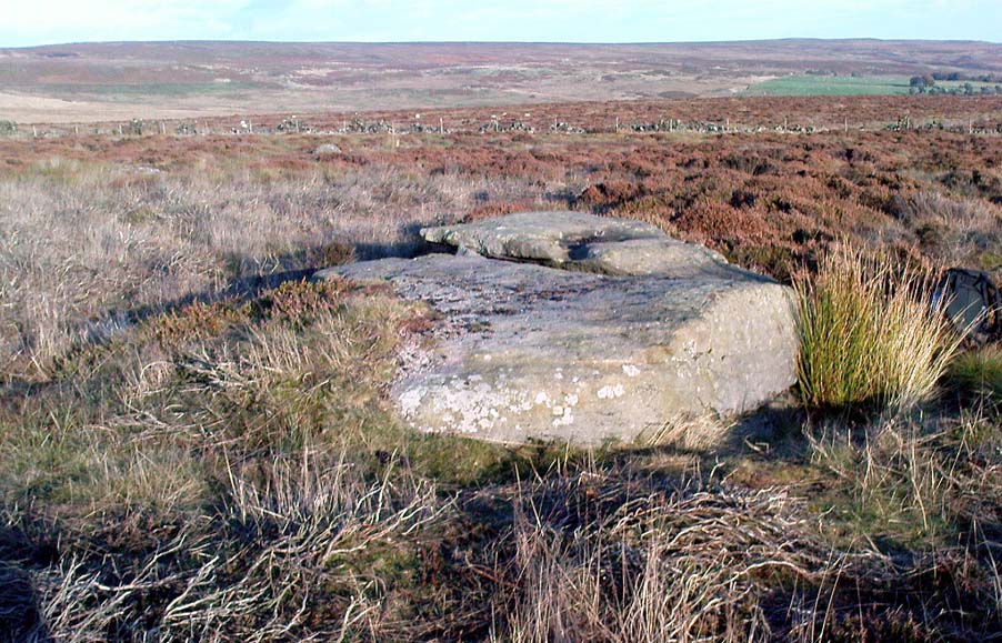
Head up to Rivock’s Wondjina Stone carving, then keep going east to the Long Rock.  Wander 100 or more further east till you see the fence, and about 50 yards before this check out the large rocks which you’ll notice near to each other.  One of them is this Split Rock!

Archaeology & History

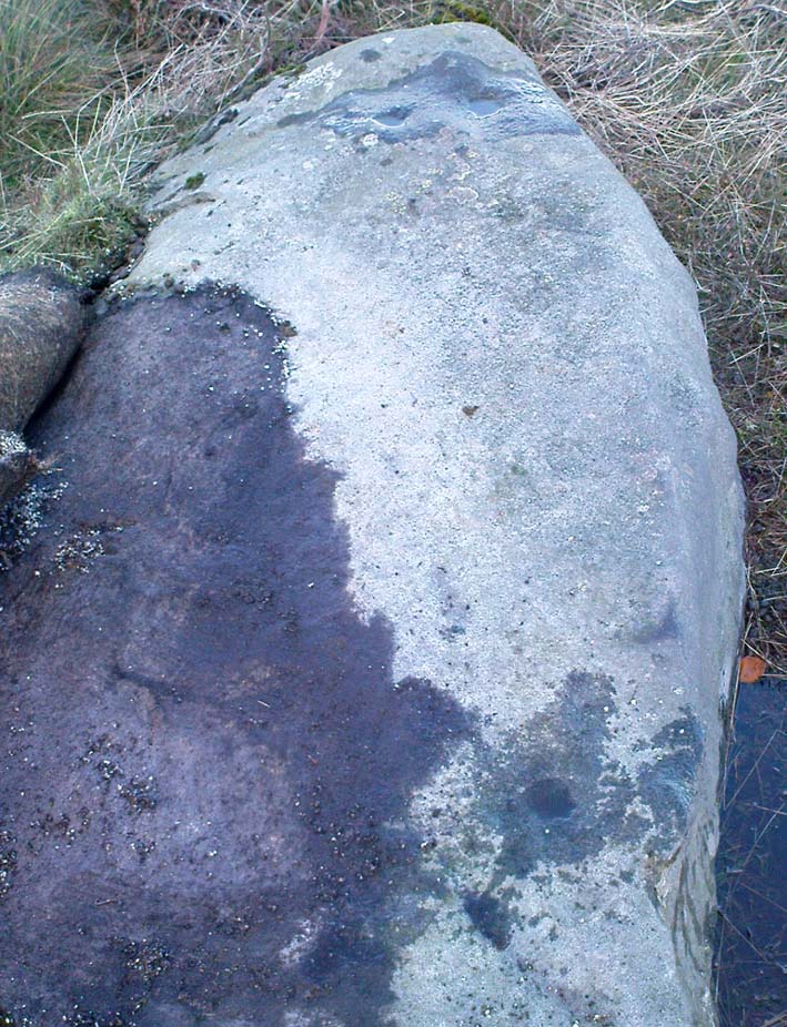
First described in Hedges’ (1986) survey, this is a large flattish boulder, split across one side, with two distinct cup-marks on its eastern side and a number of other ‘possibles’ scattering the surface.  The most intriguing bit to this rock is on its lower eastern side.  Here’s what Boughey & Vickerman (2003) described as,

CR80-2
Deep cup-and-half-ring

“one clear cup (doubtful) discovered under turf…at extreme lower SE corner, with possible attempt at pecked partial ring.”

This cup they describe as “doubtful” is quite deep, but the half-ring on its northern side has definite artificial peck-marks.  I’m more of the opinion that this cup-and-half-ring is man-made — though whether it was done in more recent years is the more debatable aspect here.  I’ll try getting some better images (and a drawing) of this stone when we’re next up here.

References:

  1. Boughey, Keith & Vickerman, E.A., Prehistoric Rock Art of the West Riding, West Yorkshire Archaeology Service 2003.
  2. Hedges, John, The Carved Rocks on Rombalds Moor, WYMCC: Wakefield 1986.

© Paul Bennett, The Northern Antiquarian

Long Stone, Rivock, Keighley, West Yorkshire

Cup-Marked Stone:  OS Grid Reference – SE 07833 44313

Also Known as:

  1. Carving no.78 (Boughey & Vickerman)

Getting Here

Head up to the lovely Wondjina Stone carving, then walk east towards the triangulation pillar. Keep going, over the wall – and keep going straight on, over the next wall (no footpaths up here at all).  You’re now into rough heathland, but if you’re a real cup-and-ring freak, keep heading another 150 yards east, zigzagging slightly.  You’ll eventually find it!

Archaeology & History

CR78
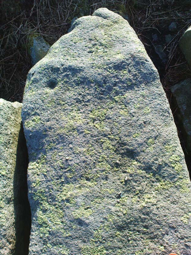
Long Rock carving, Rivock

A quite large, smooth earthfast rock, but nowt much to look at unless you’re one of the crazy bunch!  This is just another one of our basic cup-marked rocks with very little modern archaeo-history attached.  There are perhaps as many as four cup-markings etched onto the stone: two at the northern end, one a little further down (not mentioned in Boughey & Vickerman’s survey) and another one cited towards the south end of the stone.  Gotta be honest though: a couple of them are slightly dubious and may be natural — but hopefully not! (soz about the crap photo of this poor carving; but the light was shit & our camera packed-up!)

References:

  1. Boughey, Keith & Vickerman, E.A., Prehistoric Rock Art of the West Riding, West Yorkshire Archaeology Service 2003.

© Paul Bennett, The Northern Antiquarian


Long Stone, Ilkley Moor, West Yorkshire

Cup-Marked Stone:  OS Grid Reference – SE 13282 46222

Also Known as:

  1. Carving no.161 (Hedges)
  2. Carving no.326 (Boughey & Vickerman)

Getting Here

CR326
Large single cup-marked rock

Follow the same directions to reach the Pancake Stone, but about 100 yards west, following the footpath that runs along the edge of the ridge (towards the large Haystack Rock a few hundred yards west), watch out for these large seemingly split rocks, with one elongated length of stone by the pathside.  You can’t really miss it!

Archaeology & History

Very little’s been said of this carving as it’s just one more of the many rocks with just a solitary cup-marking etched on top — as we can see in the photo.  The cup-mark is near the bottom, southeast-ish portion of the rock and is plain to see.

(Note: I’m not 100% sure that I’ve got Boughey & Vickerman’s (2003) numbered carving correct here.  They describe a carved rock very close by here as an “upstanding rock, part of a large split rock,” as their ‘number 326’ carving — which is roughly similar; though I’m not totally sure!  No other single cup-marked stone is listed in their survey close by, so assume it’s the same one as in their work.)

References:

  1. Boughey, Keith & Vickerman, E.A., Prehistoric Rock Art of the West Riding, West Yorkshire Archaeology Service 2003.
  2. Hedges, John, The Carved Rocks on Rombalds Moor, WYMCC: Wakefield 1986.

© Paul Bennett, The Northern Antiquarian


Fairy Well, Barrow Gurney, Somerset

Sacred Well:  OS Grid Reference – ST 53243 68625

Getting Here

Fairy Spring on 1921 OS-map

Go up the nicely-named Wildcountry Lane at the staggered crossroads on the edge of Barrow Gurney for about a half-mile, watching out for the dip in the road where it crosses the stream.  Walk up the stream here for a coupla hundred yards, keeping your eyes peeled for the small spring on your left just past where a footpath crosses the stream.

Archaeology & History

Little of historical nature is known of this site, found in the dip near the stream, though it was much frequented in bygone centuries as a curative place for sore eyes.

Folklore

Although named after the little people, Phil Quinn (1999) wrote that,

“even the oldest villager cannot remember how the fairies became connected with this well.  All that is told is that the people would go to the well to bathe their eyes, for the water was believed to be good in the treatment of all eye complaints. A local woman remembers that her father, who worked the land in this neighbourhood, would always drink from the well using a cup which was never taken away or used for any other purpose.”

It is likely that the fairy association here derived from the proximity of a nearby prehistoric tomb, cairn or similar archaeological remain.  The aptly-named Barrow Wood immediately east and other ‘barrow’ place-names nearby would add weight to this notion. (faerie-lore has widespread associations with prehistoric tombs and similar relics)

References:

  1. Quinn, Phil, The Holy Wells of Bath and Bristol Region, Logaston: Almeley 1999.

© Paul Bennett, The Northern Antiquarian


Frensham Common necropolis, Frensham, Surrey

Tumuli:  OS Grid Reference – SU 853 406

Archaeology & History

There are several tumuli near the top of the hill here, but only one of them really stands out.  Nick Thomas (1976) told it to be one “of the best preserved bowl barrows in Surrey.”  A brief description of the relevant tombs, running north to south:

“the first is 75ft across and 6ft high; the second, which has a surrounding ditch 9ft wide, is also 75ft across, but is 8ft high.  The third has a diameter of 42ft and a height of 4ft.  The last is 54ft wide and 5½ft high.  It has a surrounding ditch 8ft wide. ” (Thomas 1976)

None of the tombs had been excavated up to the early 1980s, but I’m not sure if anything has been found since then.  There was also a potential “great stone” up here that was mentioned by John Aubrey in the late 17th century, but nothing has been seen of it since.  In all probability this was a standing stone or the remains of some prehistoric tomb.

Folklore

Several hundred years ago the King’s antiquary, John Aubrey, told the curious tale of the great cauldron that was said to have been found here:

“In the vestry (of Frensham church, in Surrey), on the north side of the chancel, is an extraordinary great kettle or caldron, which the inhabitants say, by tradition, was brought hither by the fairies, time out of mind, from Borough-Hill, about a mile hence. To this place, if anyone went to borrow a yoke of oxen, money, etc., he might have it for a year or longer, so he kept his word to return it. There is a cave where some have fancied to hear music.  On this Borough hill…is a great stone lying along, of the length of about six feet. They went to this stone and knocked at it, and declared what they could borrow, and when they would repay, and a voice would answer when they should come, and that they should find what they desired to borrow at that stone. This caldron, with the trivet, was borrowed here after the manner aforesaid, and not return’d according to promise; and though the caldron was afterwards carried to the stone, it could not be received, and ever since that time no borrowing there.”

In relation to the folklore that is generally attached to the tumulus on top of the hill here from which modern lore ascribes the cauldron to have originated, when A.G. Wade (1928) came to investigate the nature of the site and the folktale he found that,

“there are several folk-tales other than those given by Aubrey.  One relates that it was dug up on Kettlebury Hill, south of Hankley Common, by the monks of Waverley Abbey, and that it was taken by them to Frensham for brewing ale.  Another tale says that it was a loan from the fairies of Thursley — there are tumuli in this parish, south of Ockley Common — and that Mother Ludlam, a medieval witch who lived, according to tradition, in Ludlam’s Cave in Moor Park, was the owner and lender.  The cave was dug by a monk of Waverley Abbey who, when the water supply of the Abbey failed, found that three springs joined here, and by enlarging their outlets and bringing them together he obtained a good supply of fresh drinking water…”

Mr Wade was also unable to satisfactorily show that the Borough Hill named in Aubrey’s survey and Frensham Common hilltop were one and the same.

References:

  1. Aubrey, John, The Natural History and Antiquities of Surrey, E. Curll: London 1719.
  2. Thomas, Nicholas, Guide to Prehistoric England, Batsford: London 1976.
  3. Wade, A.G., “The Great Cauldron of Frensham,” in Antiquity, 2:6, June 1928.

© Paul Bennett, The Northern Antiquarian