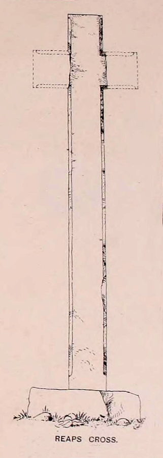
‘Standing Stones’: OS Grid Reference — TL 1395 9839
Also Known as:
- St. Edmund’s Stones
Archaeology & History
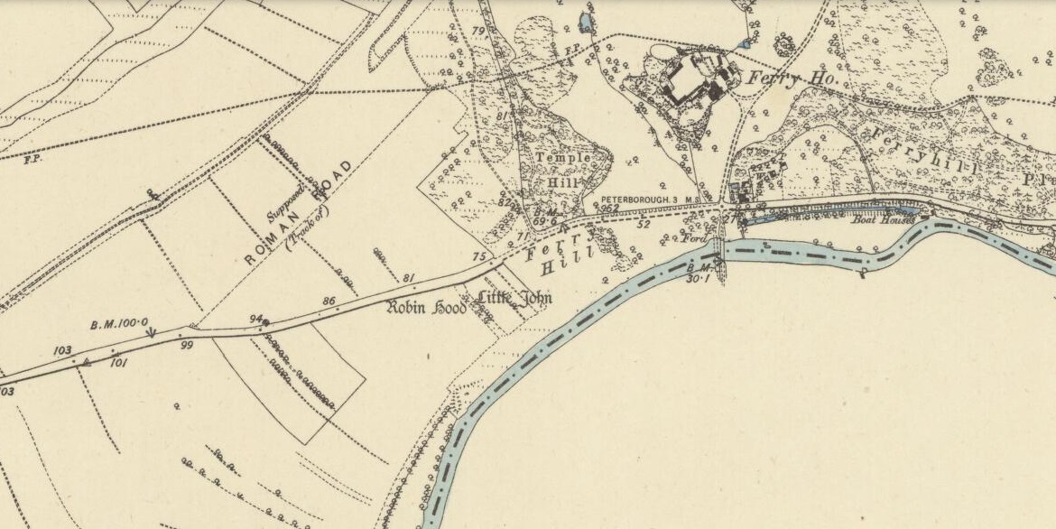
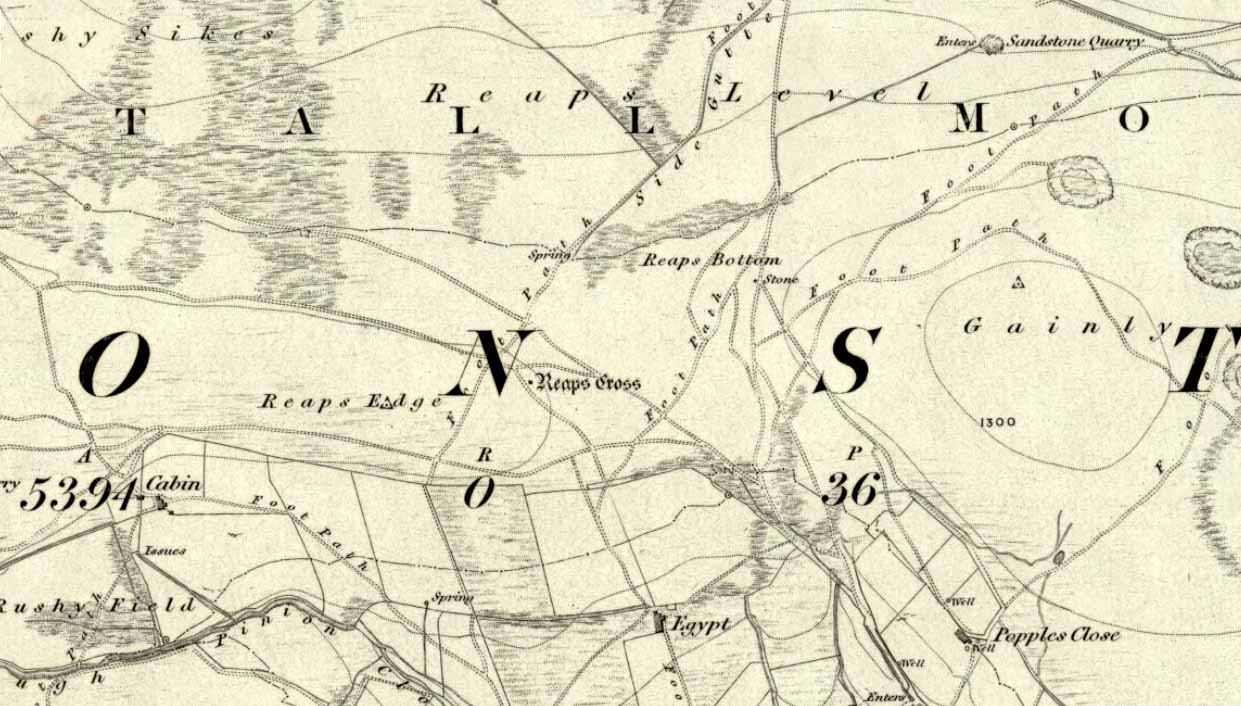
1885 OS-map of the site
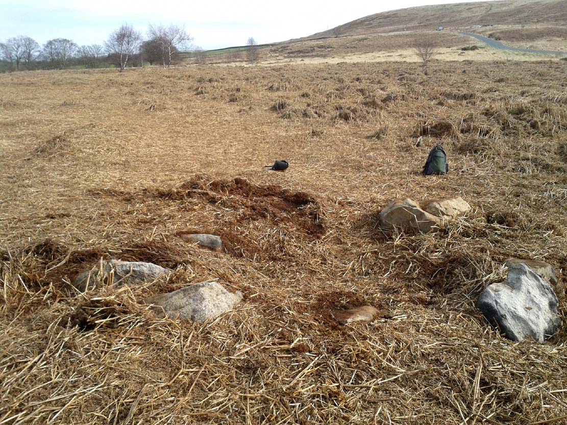
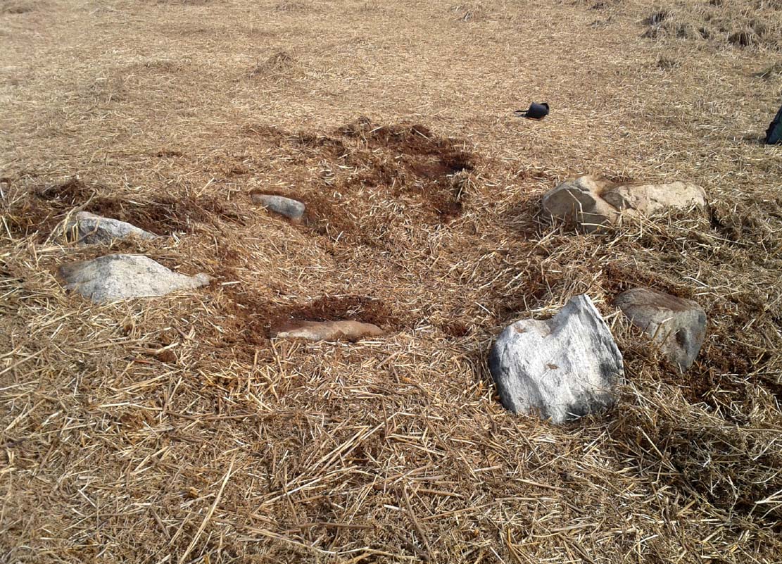
A curious and intriguing site with as many questions about its nature as there is its folklore. Moved around by the conniving fuckwit politicians from Huntingdonshire, to Northants to Cambridge nowadays, one wonders where those fools will place it next! Listed by a number of archaeologists as prehistoric standing stones, it seems pretty obvious from photos and the descriptions of many amateur students that—unless some original monoliths have been reworked a few centuries back—the narrative given by local historian W.H.B. Saunders (1888) outlines their more probable origin and history. That’s not to say that the stones aren’t old—just not that olde…. Mr Saunders reasoned that they were dug and transported from more than 5 miles northwest of their present spot, telling that:
“Nothing can rob the stones of their undoubted antiquity. The Barnack quarries have been exhausted for the last 600 years at least. It is evident therefore, that the stones were placed in their present position at a time when the Barnack quarries were being worked. That would be in the days of Robin Hood, and also when the Abbey of St. Edmund’s Bury, built of Barnack stone, was being erected.”
His words make sense when you look at the stature of the monoliths in question. They’re cut and squared to the edges, with Robin Hood being the taller of the two stones, about 30 feet southwest of the Little John stone. They have been written about quite extensively by historians down the centuries, from William Camden onwards. One early account of the stones was written by Symon Gunton (1686) who told:
“I find in the charter of King Edward the confessor…that the abbot of Ramsey should give to the abbot and convent of Peterburgh 4000 eeles in the time of Lent, and in consideration thereof the abbot of Peterburgh should give to the abbot of Ramsey as much freestone from his pitts in Bernack, and as much ragstone from his pitts in Peterburgh as he should need.
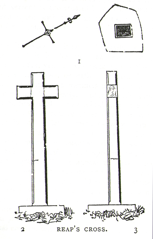
“Nor did the abbot of Peterburgh from these pits furnish only that but other abbies also, as that of St. Edmunds-Bury: in memory whereof there are two long stones yet standing upon a balk in Castor-field, near unto Gunwade ferry; which erroneous tradition hath given out to be draughts of arrows from Alwalton church-yard thither; the one of Robin Hood, and the other of Little John; but the truth is, they were set up for witnesses, that the carriages of stone from Bernack to Gunwade-ferry, to be conveyed to S. Edmunds-Bury, might pass that way without paying toll; and in some old terriars they are called St. Edmund’s stones. These stones are nicked in their tops after the manner of arrows, probably enough in memory of S. Edmund, who was shot to death with arrows by the Danes. The balk they stand upon is still call’d St Edmund’s Balk. They are supposed to be the petrify’d arrows of those two famous archers.”
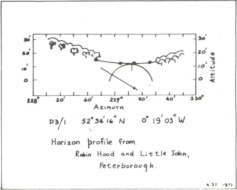
Thom’s sketch showing his midwinter alignment
These traditions have subsequently been copied by all local historians. So it is something of a curiosity to find our archaeologists—from Clarke (1960) and F.M. Pryor (1972) to Aubrey Burl (1993)—to cite these as prehistoric monoliths. My suspicions as to their reasons relates to the folklore of the stones which are echoed at many truly prehistoric places like the Devil’s Arrows, etc. The nature of the tale is an aboriginal creation myth, relating to the formation of sites as understood in animistic mythic structures. But this archaeological misunderstanding brought the more scientific mathematical mind of Alexander Thom (1990:1) here in the 1980s where coincidence showed a common astronomical alignment. Thom wrote:
“Clearly visible from the site, at an azimuth of 229°.22 is the lowest point of a low saddle on the horizon. The col, Fig.1 (above), subtends an arc of about 0°.67 of azimuth, observed minimum altitude 0°.21. For an estimated temperature of 44°F, correction for refraction at sunset is about 0°.54, and for solar and semi-diameter and parallax of respectively 0°.27 and 0°.002, the ‘observed’ declination is found to be -23°.92, which indicates a date of about 1860 BC.
“No presently obvious horizon marker was evident upon inspection of the open fields forming the horizon, but this does not mean that a foresight was never erected. Without the evidence of a foresight it cannot be claimed that the two stones were placed for accurate calendrical reasons, but undoubtedly they indicate by themselves the winter solstice.”
The folklore may indicate the possibility that these two medieval standing stones replaced earlier ones, but no remains of such relics exist today.
References:
- Burl, Aubrey, From Carnac to Callanish, Yale University Press 1993.
- Clarke, R. Rainbird, East Anglia: Ancient Peoples and Places, Thames & Hudson: London 1960.
- Gover, J.E.B., Mawer, A. & Stenton, F.M., The Place-Names of Northamptonshire, Cambridge University Press 1975.
- Grinsell, Leslie V., Folklore of Prehistoric Sites in Britain, David & Charles: London 1976.
- Gunton, Symon, The History of the Church of Peterburgh, Richard Chiswell: London 1686.
- Mee, Arthur, Bedfordshire and Huntingdonshire, Hodder & Stoughton: London 1973.
- Morton, John, The Natural History of Northampton-shire; with Some Account of the Antiquities – 2 volumes, R. Knaplock: London 1712.
- Pryor, F.M., Prehistoric Man in the Nene Valley, Nene Valley Research: Peterborough 1972.
- Saunders, W.H.B., Legends and Traditions of Huntingdonshire, Simpkin Marshall: London 1888.
- Serjeantson, R.M. (ed.), The Victoria County History of Northamptonshire – volume 2, London 1906.
- Thom, Alexander, Thom, A.S. & Burl, Aubrey, Stone Rows and Standing Stones – volume 1, BAR: Oxford 1990.
- Thom, A.S., “A Solstitial Site near Peterborough,” in Journal of the History of Astronomy, 11, 1980.
© Paul Bennett, The Northern Antiquarian