Go up the A93 road from Blairgowrie, after 5 miles turn right at the Bridge of Cally and up Glen Shee. After another 3½ miles, keep your eyes peeled for the iny road on the right signposted to the Drumturk Cheese farmshop. Go up this long tiny winding road, a mile up past the cheese place (which are gorgeous btw!) and onto the open moors. Keep on this road for another 2¼ miles where you can park up near the entrance to the huge wind-farm. Walk up the track to the windmills, bearing right at the first junction, then right again at the next one. From here, walk to the second windmill and from its base walk down, east, into the heather for about 80 yards. You’re damn close!
Archaeology & History
Drumderg (3) carving
On this T-square-shaped earthfast stone, a hundred-and-twenty yards north of the impressive Drumberg (2) petroglyph and just 10 yards below the remains of an impressive hut circle, we find this somewhat plain cup-marked design. It was covered pretty deeply beneath the heather when we came here and it took some time before we could see what we were looking at. The grey skies and poor daylight didn’t help matters either, as the cups were difficult to make out at first, but, thankfully, you can just about see them in the photos.
There are between five and seven shallow but distinct cup-markings on the flat surface, one of which may have a faint ring around it. In truth, this carving’s only gonna be for the real geeks amongst you.
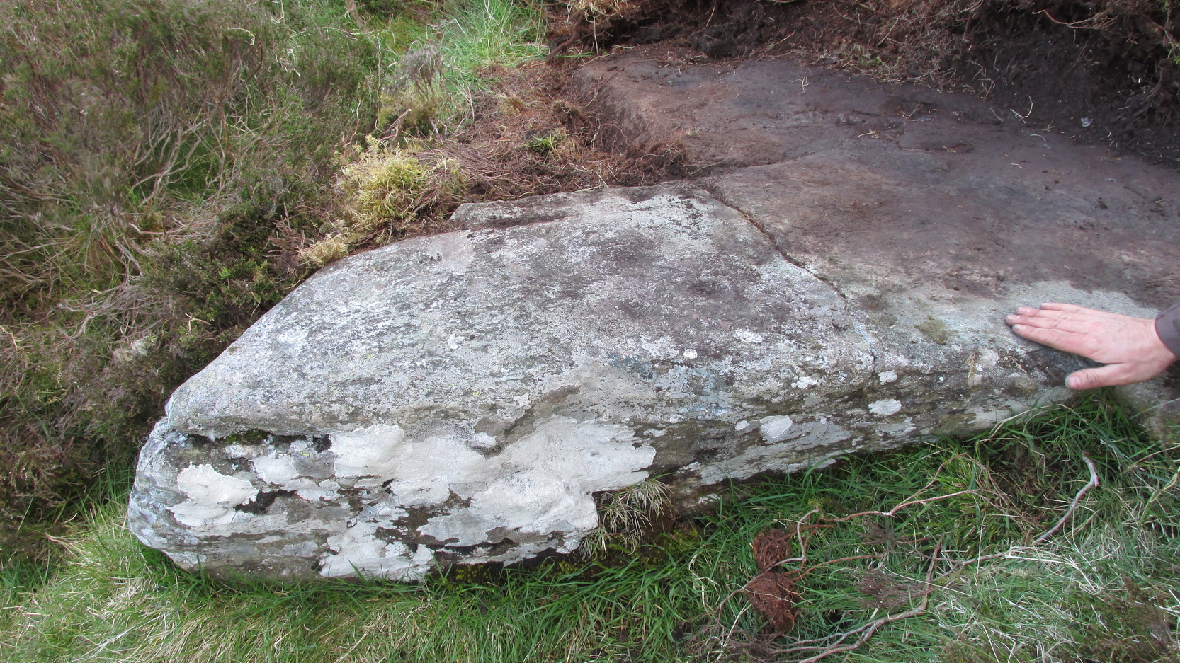
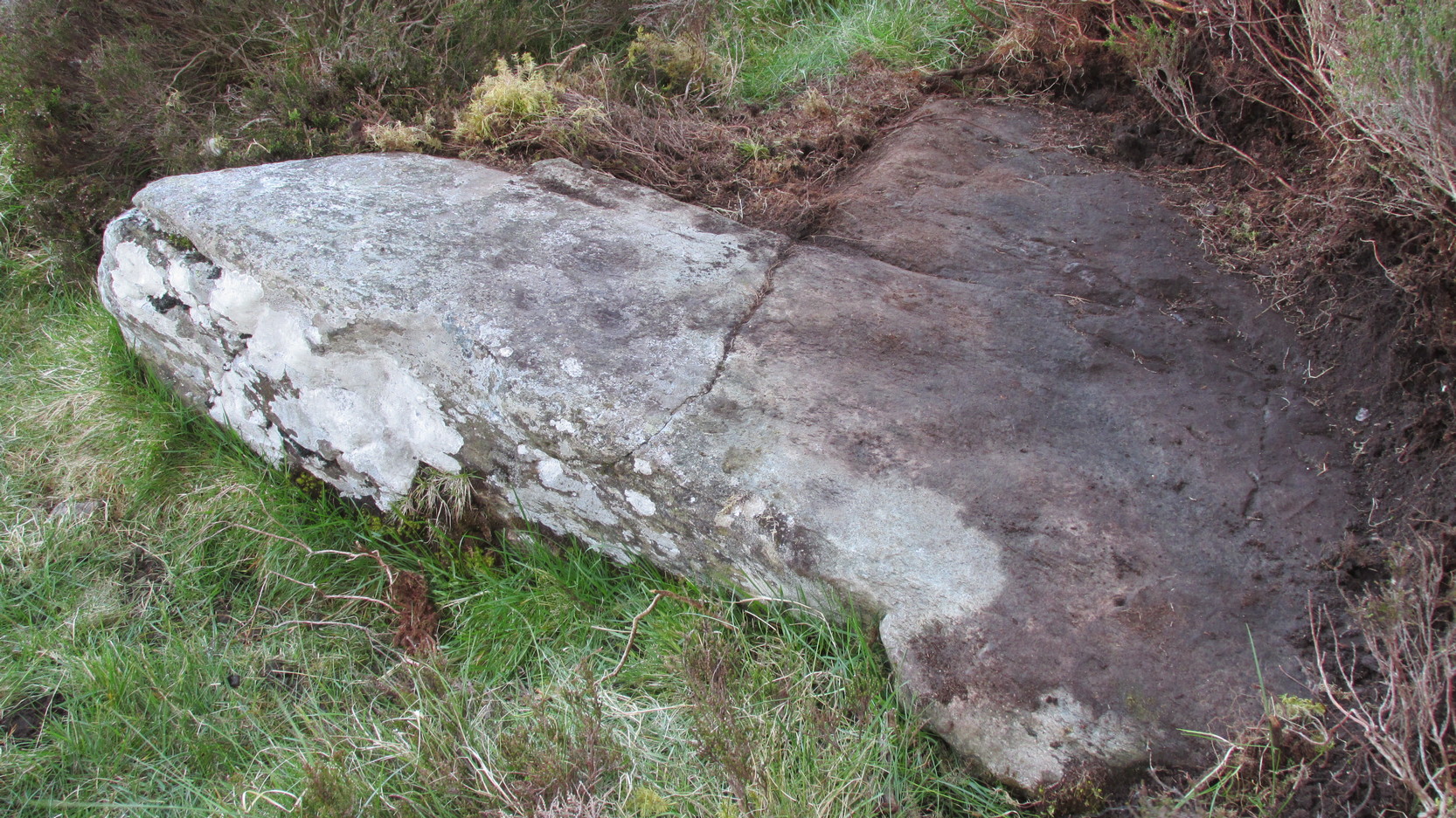
Takes a bitta finding and aint too accessible for those of you who need footpaths! Below the eastern slopes of Addlebrough Hill, by the present source of the Gill Beck right beneath the Dove Stones (the water tastes gorgeous), are the ruinous remains of an old sheepfold. In the field immediately behind (south) of here are a number of small rocks. Look around and you’ll find the stone in question!
Archaeology & History
Unless you’re a real rock-art-freak, I can’t imagine too many of you checking this one out! When Richard Stroud and I visited this spot a few years back (2006), it was a mixture of love and madness that brought us here!
Dove Stones Carving
Amidst the many stones scattered hereabouts, one of them possesses two clear cup-marks on a stone measuring roughly 3ft by 2ft, along the line of a much ruined ancient wall. This might be the one that Beckensall and Laurie (1998) described in their Prehistoric Rock Art of County Durham, Swaledale and Wensleydale, as “a rock with several cups (which) has recently been noticed on Thornton Rust Moor, near the Dovestones” — though it seemed blatantly apparent to us that there were only two cups here, not “several”. However, Brown (2008) appears to list the site, citing it as having “two cups”, just like the one we found, and being “found in prehistoric low field settlement wall,” which fits the picture perfectly — although Brown gives a slight difference in grid-reference to the one Richard Stroud took. It looks a good area to scout around and, I reckon, find previously unrecorded sites.
References:
Beckensall, Stan & Laurie, T., The Prehistoric Rock Art of County Durham, Swaledale and Wensleydale, County Durham Books 1998.
Brown, Paul & Barbara, Prehistoric Rock Art in the Northern Dales, Tempus: Stroud 2008.
Get to Widdop reservoir in the hills west of Hebden Bridge and park up. The great rock faces to your right (north) is where you’re going. Clamber to the top until the moor levels out, making sure you head NNW for less than a mile. The moors you’re now on are supposed to be private – but folk like me pay no attention! There are no footpaths to this great outcrop, only the heathlands and scattered stones – but keep walking for a half-mile north and you’ll get to them!
Archaeology & History
Erroneously ascribed by the place-name masters Eilert Ekwall and A.H. Smith (1961) as being ‘a place where doves gathered,’ this gigantic rock outcrop on the Yorkshire-Lancashire border — as shown on early maps — is actually the Dew or Black Stones (from the Gaelic, dubh). It’s an awesome place! Takes a bitta getting to, but it’s well worth the venture.
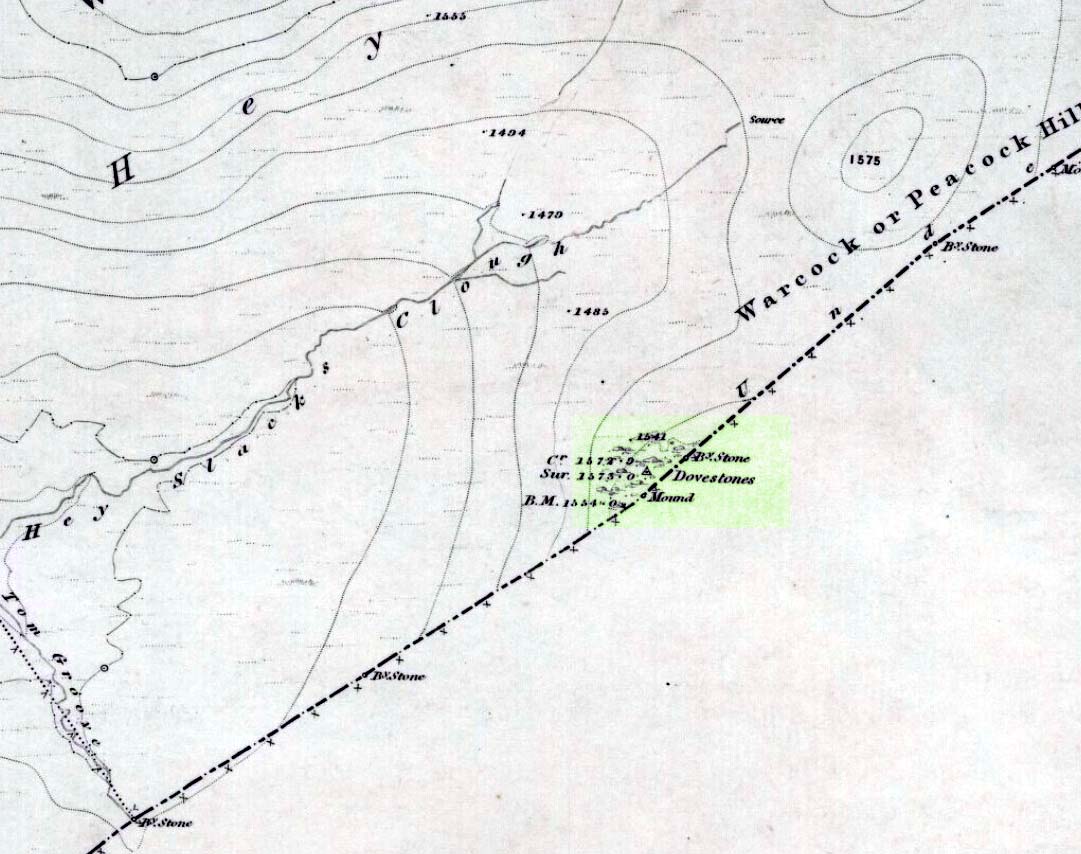
Dove Stones on 1848 map
This long geological ridge, rising higher as you walk along it to the north, has the occasional cup-mark on it, with the giant Dove Stone at the very end having a cup-and-half-ring on its crown (be careful not to fall off). From here, you look across a huge, desolate, U-shaped valley, the far side of which we rise to 1700 feet and the grand setting of the Lad Law.
Folklore
The folklorists Harland and Wilkinson (1882) included this in their survey of druidical sites, mentioning the several cup-markings, or druid basins as they called them. (though most of ’em on here are Nature’s handiwork)
For me, this is an incredible place – full of raw power and magick. It has a curious geomantic relationship with the Whinberry Stones, a couple of miles to the south, around which should be a ring of stones…though none can be found.
This is a stupendous site! It looks like some of this may have been quarried, a long time ago, but it also seems that nothing at all has been written about it – even in the simple travelogues beloved by our Victorian historians. To come across it quite by accident, as I did (only yesterday), was excellent! When I first got here, by following the wooded ridge betwixt Hollins Lane and the main Keighley-to-Steeton road (A629), the place seemed brilliant; but as time went on and my amblings through the sometimes dense and also very old woodland were overcome by the dream of the place, I couldn’t believe how this place had become forgotten. Adrenalin rushed through me for a while, but then it was the dream of the place again. The memories here were ancient – and you could feel them. In places there was the solace of darkness, beloved of those who know old trees and dangerous places. For here, walk the wrong place too quickly and Death comes. Broken limbs await in the curious gorges which just appear in the woods, only a yard wide, but 50-60 foot deep, only to vanish again away from sight a few yards later. Caves and dark recesses, seemingly unknown, reach out to climb down. And all round is the aged covering of lichens and mosses that know centuries.
Shown as ‘Garlic Kirk’ on 1853 map
The Kirk itself – meaning simply, ‘place of worship’, in the old sense – is like something out of Lord of the Rings! If you walk along its top, as I did, the great cliffs below come late to the senses. A curious ridge of cup-markings, seemingly natural ones, stretch along the very edges of the drop – which stretches on for some distance. And then as you walk along its edge, you find this great drop which looks north, is now on both sides of your feet! It’s quite breathtaking!
Cup-markings on the edge (probably natural)
Trying to get down into the gorge below can be done, but it’s a bit dodgy! If you aint agile and crazy, stick to doing it by walking round – a long way round… Someone a few centuries back either cut into the rock, or laid steps, reaching into the mossy gorge, which runs to nowhere.
You can appreciate how this place would have been a sacred site: it’s big, it’s old, it takes your breath away, and it looks across to the great Rivock Edge where many fine cup-and-ring stones were cut. I’ll try and get some images of the place when I call here again in the very near future, but they’ll never capture the experience of being here.
Folklore
The only thing I have come across which seemingly relates to this great edifice, tells of a great cave in the woodland, which legend tells stretches many miles to the north and emerges at Bolton Abbey. (Clough 1886) I wondered about the potential visibility factor in this legend and found it obviously didn’t work. However, if you stand on a certain part of The Kirk and look north, a dip in the horizon enables us to see, far away, hills which rise up directly above the swastika-clad Bolton Abbey. Twouldst be good to work out exactly which hill above the Abbey we can see from here.
On another issue, John Clough (1886) told that “on top of the rock there is a footprint and the initials of one of the Waites, who is said to have leaped over the chasm.”
References:
Clough, John, History of Steeton, S. Billows: Keighley 1886.
Gray, Johnnie, Through Airedale from Goole to Malham, Walker & Laycock: Leeds 1891.
Described by Tam Ward and Douglas Graham (1989) as “the only surviving standing stone in Clydesdale” (which isn’t quite true), this lovely looking monolith, leaning to one side, appears to have several cup-markings on its surface, but they’re actually Nature’s handiwork. The stone aligns to the hill a short distance north, Bodsbury Hill, upon which a fortress was later built sometime in the Iron Age.
I must have a wander round this region sometime: there’s some very attractive place-names nearby crying out for archaeo-attention to rub myself up and down upon!
References:
Royal Commission on the Ancient & Historic Monuments of Scotland, Lanarkshire: An Inventory of the Prehistoric and Roman Monuments, HMSO: Edinburgh 1978.
Ward, Tam & Graham, Douglas, Ancient Monuments of Clydesdale, CDC: Lanark 1989.
From Ilkley town, head up the road as if you’re going to White Wells but keep following the moorland road up towards Whetstone Gate and the TV masts on the very tops (you’ll have to walk the last half-mile). Shortly before you get them, you can’t miss this relic by the track-side on your right-hand side.
Archaeology & History
Possibly a christianised monolith, erected here in an attempt to divert local people away from the impressive Badger Stone where they may have held springtime gatherings. There used to be an old monolith laid on the ground a few yards away from the cross, which may have stood upright before the cross was erected. Also on the south-facing side of the cross were four cup-markings, indicating great age. These may also have been added when the cross was erected. (We know this occurred at other sites in the region, e.g., Churn Milk Joan, Midgley Moor, where such cup-marks were added sometime in the 15th or 16th century.) However, thanks to some idiotic halfwits in more recent years going up here and vandalizing Cowper’s Cross, the prehistoric cup-markings that were on this relic have been destroyed. The upright shaft of the cross that’s here now is a re-worked gatepost that replaced the old shaft with its authentic ‘pagan’ carvings.
1920s postcard of the Cross
But it’s had other bits of bad luck through the years. The site was struck by lightning many years back, splitting the stone in half, but has since been rebuilt and stands adjacent to its original position, right next to the old Roman road that crosses Ilkley Moor. Historian Allan Butterfield suggested this site to have originally been an old boundary markstone, christianised many centuries ago. The name ‘Cowper’ derives from the local Ilkley family of Cawper.
Those of you interested in the early christian history of these moors should also have a look at the little-known Black Knoll Cross, less than a mile south of here in the middle of Morton Moor.
Folklore
Folklore relates that markets were held at this old stone cross many years ago. This gives added weight to the idea that the nearby cup-and-ring marked Badger Stone, where markets were probably held around the time of the equinoxes, was the original site for such gatherings. Note that another site, the Reva Hill Cross, on the eastern side of this moor, has much the same history.
References:
Bennett, Paul, The Old Stones of Elmet, Capall Bann: Chieveley 2001.
Cowling, E.T., Rombald’s Way, William Walker: Otley 1946.
Go through Laycock village and take the left turn along the lovely, hidden country lane towards Slippery Ford (called Todley Hall Road) until you get near the end of this beautiful wooded valley (called Newsholme Dean). Just by Grey Stones Hill, on your left, is a track heading down to a large farm building with numerous rocks and boulders in the fields either side of you. Stop! – and look in the field on the right.
Archaeology & History
Cluster of cup-marks
This particular stone is in the field to the right of the track, over the wall, right near the top of the field. Described for the first time in Boughey & Vickerman’s (2003) survey where they describe “at least eight cups” on the rock; and it’s listed on the MAGIC Map survey as having 6 cups — which are the ones you can plainly see on the very top edge of the stone. What may be three other faint ones can be discerned on the sloping sides of the rock.
Cob Stone Field carving
Another ‘possible’ cup-marked stone can be seen lower down the field, past the large Cob Stone. There is also another cup-marked stone in the adjacent field at SE 00610 40841 (listed as stone no.2 in Boughey & Vickerman, 2003) with apparently 17 cups on the large rock there, but this can be difficult to see unless lighting conditions are just right.
References:
Boughey, Keith & Vickerman, E.A., Prehistoric Rock Art of the West Riding, West Yorkshire Archaeology Service 2003.
One of the best known supernatural creatures in the Scottish Highlands and Islands was one called the Glaistig: an elemental described variously as, “a thin, grey woman with yellow hair reaching to her heels and attired in green raiment”; or a deity both beneficial and dangerous, “often described as half-woman, half-goat.” Katherine Briggs (1979) wrote that sometimes this creature
“sometimes has the attributes and habits of the Cailleach Bheur, sometimes assumes animal form, often that of a goat, but more often she is described as half-woman, half-goat.”
Something decidely shaman-like!
In many of the places where she was found, she would tend for the cattle and in order to appease her, local people would pour milk into the hollowed stones by which she lived (at some places these were cup-and-ring stones). The Iona Glaistig was no exception. The great Scottish writer A.A. MacGregor (1947) mentioned this creature and its stone in one of his classic books, saying:
“In the shieling days of Iona when, during the summer months, the inhabitants of the east end and of the west end of that island were wont to pasture their cows alternately for fourteen days on the common grazing at a spot known as Staonnaig, a Glaistig dwelt in a hollow rock near at hand. For this Glaistig, the Iona women at milking-time each evening poured a little milk on what is still pointed out at the Glaistig’s Stone.”
This “pouring of milk” onto hollows in stones is a custom found in cultures from Europe eastwards into India and, no doubt, even further afield. The precise whereabouts of this sacred stone remains hidden.
References:
Briggs, Katherine, A Dictionary of Fairies, Penguin: Harmondsworth 1979.
MacGregor, Alasdair Alpin, The Peat Fire Flame, Ettrick Press: Edinburgh 1947.
Troublesome really, as it’s got lost somewhere amidst the undergrowth. From the valley bottom at Apperley Bridge, take the road-then-track which goes up thru the Calverley Cutting (as locals call it), turning left along the dirt-track just as the track begins to slope uphill. Go past the detached house in the edge of the trees and shortly past there is a small footpath taking you into the trees on your left, Walk down and along here, near the bottom of the tree-line above the walling. If you find it, let us know!
Archaeology & History
Included in Boughey & Vickerman’s (2003) survey as ‘stone 12’ – it was first described by Sidney Jackson in 1954, who later gave us a map and drawing of the stone. I looked for it several times x-number of years back, but never found it (though was led astray a little by the profusion of Amanitas in the locale!). Comprising at least 18 cup-markings on a generally flat rock surface, to this day the carving remains unfound, though is probably under the herbage hereabouts. The same fate seems to have befallen the West Woods 1 and West Woods 2 carvings in another part of the same woods. Does anyone know what’s become of them?
References:
Bennett, Paul, “The Undiscovered Old Stones of Calverley Woods,” in Earth no.2, 1986.
Boughey, Keith & Vickerman, E.A., Prehistoric Rock Art of the West Riding, West Yorkshire Archaeology Service 2003.
Jackson, Sidney (ed.), ‘Calverley Wood Cup-Marked Rock,’ in Bradford Cartwright Hall Archaeology Group Bulletin, 1:1, 1954.
Jackson, Sidney (ed.), ‘Cup-Marked Boulder in Calverley Wood,’ in Bradford Cartwright Hall Archaeology Group Bulletin, 1:7, 1955.
Jackson, Sidney (ed.), ‘Cup-and-Ring Boulders near Calverley,’ in Bradford Cartwright Hall Archaeology Group Bulletin, 1:16, 1956.
From Todmorden go east on the A646 for less than a mile and take the Cross Stone road on your left. Keep going all the way up till you hit the moorland edge road, where you’ll see the Great Rock (a massive boulder right by the roadside). Then go down Eastwood Lane, past the house where the lane swings right and here you’ll see a stile in the wall on the right (just after the next lane on your left). Walk along this path, over the stiles in the walling until you reach a wooden stile. The carving is hereby!
Archaeology & History
This carving was described just once by Mr J.A. Heginbottom (1979) as, “a small cup-marked boulder in a stile 100 metres east of Bent Head, Todmorden.” A small, innocuous stone used in the drystone walling, it gives the distinct impression of being one of the many ‘portable’ cup-marked stones typical of those found in prehistoric cairns and other tombs — but the record-books speak of no such remains here; and various ambles about in search of such a potential tomb have drawn a blank. Nevertheless, the cup-markings here are pretty obvious once you see ’em (assuming the daylight aint overcast, which can hide the carvings sometimes). About 2 feet long, about a foot wide and a foot high, this cup-marked portable is similar in size and form to the Nine Stones cup-marking, Derbyshire, recently found in walling very close to where an old tomb was recorded (though the Derbyshire one has only 2-3 cups). Certainly worth a look if you’re in the area.
References:
Heginbottom, J.A., The Prehistoric Rock Art of Upper Calderdale and the Surrounding Area, YAS: Leeds 1979.