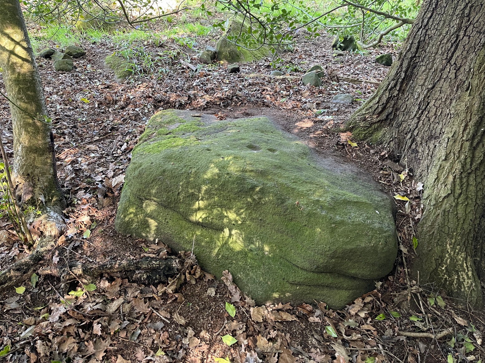
Once you’ve located the carvings of Hawksworth Spring (1) and (2), walk up the slope towards the topmost section of the walling where the land begins to level out. Hereby you’ll see the Hawksworth Spring (4) carving (if it’s not covered in leaves) several yards below the wall. Turn around and look diagonally to your left, into the trees, where you need to walk into and beneath the overhanging holly branches. Here you’ll reach the large earthfast rock whose edge rests up against the trunk of a larger tree. You can’t miss it!
Archaeology & History
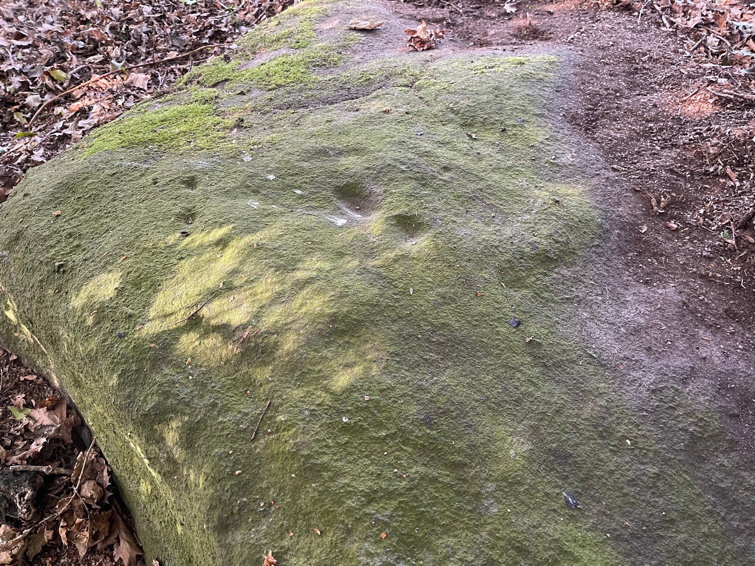
Notable curious “cups”
I’m not 100% convinced that this a prehistoric design, despite it being listed as such in Boughey & Vickerman’s (2003) survey—although, to be fair, they do suggest it as being “doubtful.” The two most notable so-called “cups” have more of a recent hallmark to them and the other elements are troublesome to see with any certainty, but they may be geophysical in nature. Their description of it told us this was a “fairly large fine-grained rock with some included pebbles. Two pairs of cups, one pair connected by groove”. Make of it what you will….
References:
Boughey, Keith & Vickerman, E.A., Prehistoric Rock Art of the West Riding, WYAS: Wakefield 2003.
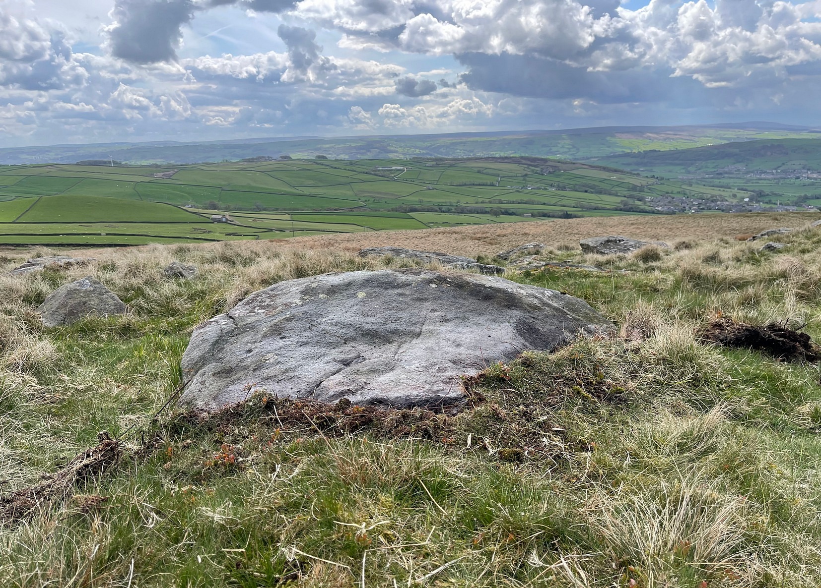
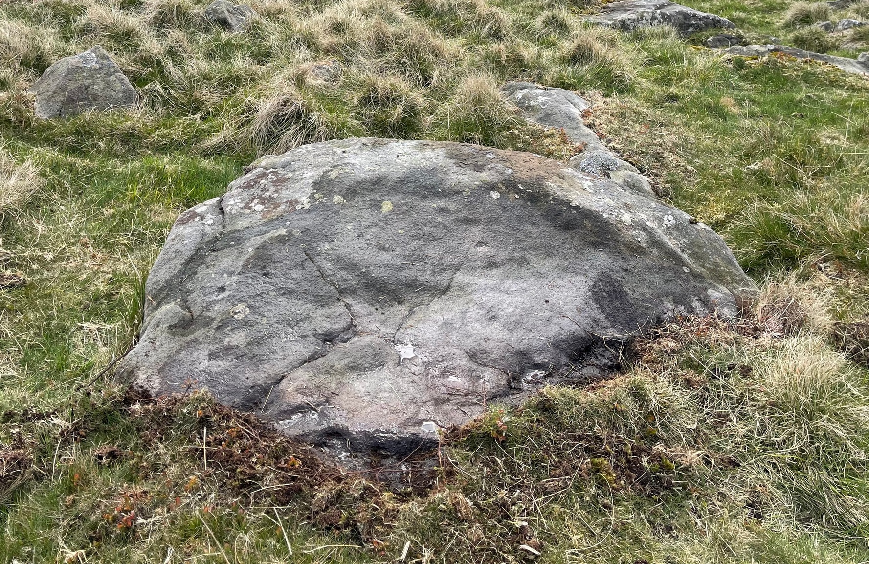
In High Bradley village, you need to go up Mill Lane for 140 yards and then bear left up High Bradley Lane for just over a half-mile, past the last row of houses on your left where it becomes a dirt-track and park-up a short distance up here. 400 yards up, in the field past the new house on your left, walk up the hill over the field, past the wall at the top and head for the large protruding boulder a few hundred yards further up on the near skyline. Once here, walk to the right of it and there’s a scatter of rocks and stones. Look around!
Archaeology & History
In an area that was extensively cut up by the Industrialists in the 18th and 19th century, Thomas Cleland came across this scarce example of a cup-marked, possibly cup-and-ring marked stone in March 2025 high up on Millstone Hill, where extensive views reach out to the south, east and west, gazing with particular attention to the mightily impressive King and Queen’s cairns, more than 1½ (2.6km) south of here—and which would have stood out much more back then than they do today.
Close-up of faint arc
An arc of cups is faintly visible on the more western-side of the stone—five, perhaps six of them. Several others are in a typically chaotic scatter across the rock, with one or two looking as if they may have been affected by the heavy industrial actions that occurred up here. When Tom first found the carving, he could see a faint ring around one of the cups near the middle of the stone, but on our visit here the sun was near its apogee and due to the slope of the rock to the north where the cups are carved, this was nigh on impossible to make out. Near the bottom edge however (as shown in the photos), a cup-and-incomplete ring seems evident; although we didn’t notice this on our visit here and it may just be a fortuitous play of the light (but I hope I’m wrong!). This is a design that mainly comes to life, so to speak, is more easily visible, when the sun is either rising or setting. (typical of many petroglyphs on flat rocks)
Acknowledgements:Huge thanks to Thomas Cleland for use of his photos in this site profile.
Cup-Marked Stone (lost): OS Grid Reference – SE 2556 4687
Also Known as:
Carving no.556 (Boughey & Vickerman)
Archaeology & History
We know very little about this carving, which was first highlighted on Eric Cowling’s (1940) map of Wharfedale petroglyphs. Described simply as one of the “cup-marked rocks”, he mentioned it briefly in Rombald’s Way (1946) as being “the most easterly carving” in mid-Wharfedale—which it was at the time (a very recent find by Benn Potts of a cup-marked stone at Weeton has pushed the boundary further eastwards). Oddly for Cowling, he left no further notes nor sketch of the carving and when Stuart Feather (1961) came to write of it, he merely copied Cowling’s earlier words. It’s not been seen since. In Boughey & Vickerman’s (2003) survey, they could find no cup-marked stone in the wood but thought instead that,
“this may be due more to confusion than to loss of the carving. Riffa Wood does contain a carving: of a Native American on a conspicuous rock alongside one of the many woodland paths. Furthermore, one or two local residents recall a German prisoner carving something on a rock in Riffa Wood during the Second World War. Presumably, this is the origin of the Native American carving. Could it be that this man added something of his own to what was already a carved rock, in which case the Native American as he now appears is the site noted by Cowling before the War?”
No cup-marks exist on this Native American carving, and it’s highly unlikely that Cowling would have made such an elementary mistake. The carving no doubt lies covered in woodland vegetation waiting, once more, for the day that someone comes along and exposes its visage to the world again. Let us know if you manage to find it…
References:
Boughey, Keith & Vickerman, E.A., Prehistoric Rock Art of the West Riding, WYAS: Wakefield 2003.
Cowling, E.T., ‘A Classification of West Yorkshire Cup and Ring Stones,’ in Archaeological Journal, volume 97, 1940.
Cowling, E.T., Rombald’s Way: A Prehistory of Mid-Wharfedale, William Walker: Otley 1946.
Feather, Stuart, “Mid-Wharfedale Cup-and-Ring Markings,” in Cartwright Hall Archaeology Group Bulletin, volume 6, no.3, March 1961.
Acknowledgements:Huge thanks for use of the Ordnance Survey map in this site profile, reproduced with the kind permission of the National Library of Scotland.
When the Grey Cairn above Balnabroich, Kirkmichael, was explored in the second-half of the 19th century by John Stuart (1865) and a number of local labourers, they found the floor of the tomb had been paved with a number of large boulders. Near its centre, along with finding remains of charred wood, they moved some of the rocks and,
“On turning over the stones a circular disc of stone with a hole in the centre was found, and also a small boulder with a cup on its flat face.”
Grey Cairn at sunfall
He made no further remarks about the carving and no intimation that it was removed, so we must presume it is still there, at the botton of the cairn. Any visitors to the site might want to have a look at the massive scatter of surface stones that make up the cairn to see if any further cup-marks exist on them. It’s not uncommon to find them on such giant tombs.
Folklore
A very curious folktale was known of the cairn in the 19th century, whose theme is recognized at numerous other prehistoric sites, but the mythic creature involved here is very much different from the ones we’re used to. Mr Stuart told that,
“The popular belief is that a mermaid is buried beneath it. This mermaid used to throw stones at people who were coming from church at Kirkmichael, and she could only be seen through a hole in the knot of the pine tree. At last she was chased to the hill at Balnabroch on her flight to the waters of Loch Marech, on the other side of the hill, and there killed, when the Grey Cairn was raised over her.”
References:
Royal Commission on the Ancient & Historical Monuments of Scotland, North-East Perth: An Archaeological Landscape, HMSO: Edinburgh 1990.
Stuart, John, “Account of Excavations in Groups of Cairns, Stone Circles and Hut Circles on Balnabroch, Parish of Kirkmichael, Perthshire,” in Proceedings Society Antiquaries, Scotland, volume 6, 1865.
Acknowledgements:Huge thanks for use of the Ordnance Survey map in this site profile, reproduced with the kind permission of the National Library of Scotland.
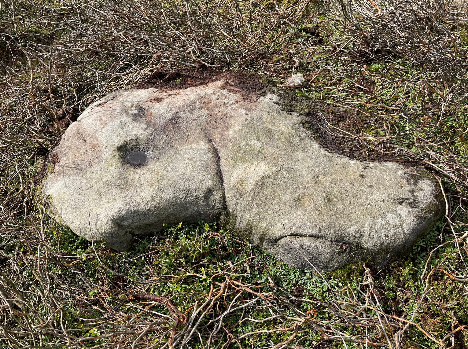
From near Skipton town centre, at the Cross Keys Inn along Otley Road, go up Short Bank Road all the way to the very top and then into the trees onto the Dales High Way footpath. Walk up for literally ¼-mile (0.4km) and where the path bends and heads ENE, notice here a footpath that takes you over the wall. Once on the other side, the path splits with one heading SE and the other roughly alongside the walling to the SW, which is where you need to go. About 200 yard on, go through the gate into the field and then another 375 yards on you’re into another field (copse of trees in front of you). Just as you’ve gone into this field, walk immediately left, uphill, by the walling for about 100 yards, over the marshy dip, then head into the field where, about 75 yards in, you’ll see some rocks scattered about…
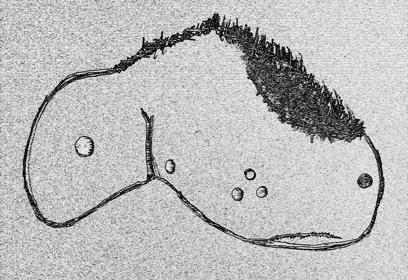
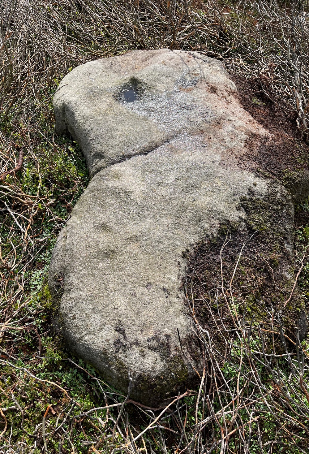
Archaeology & History
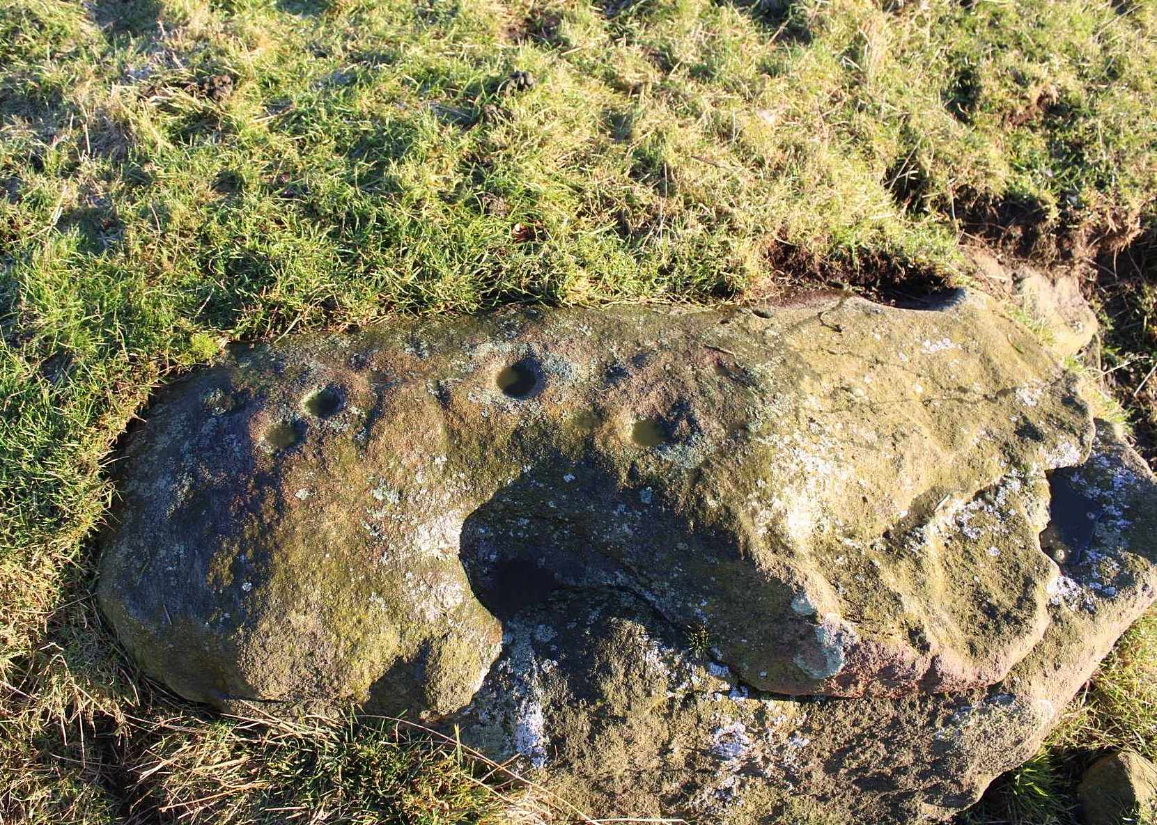
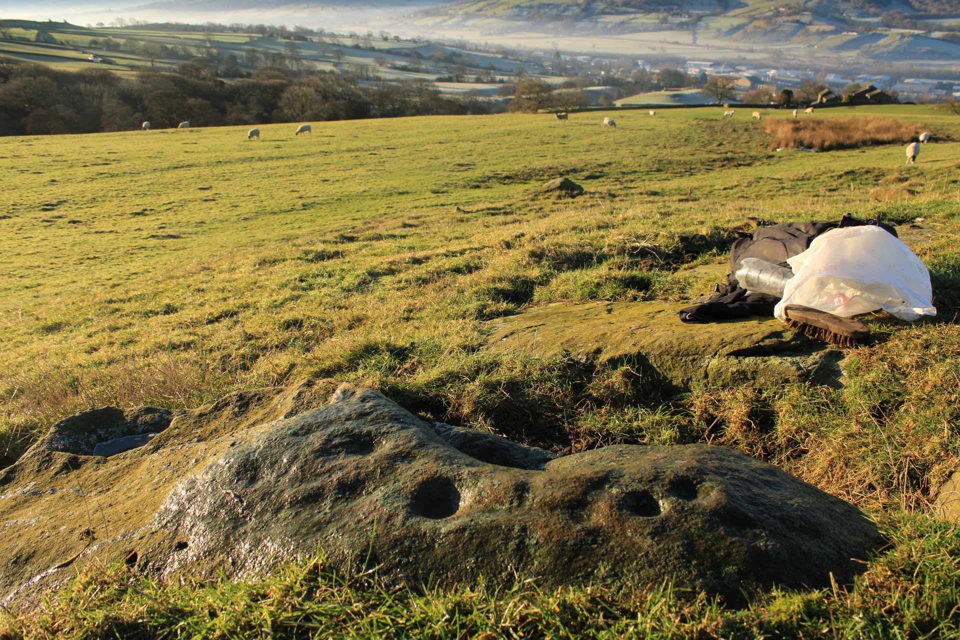
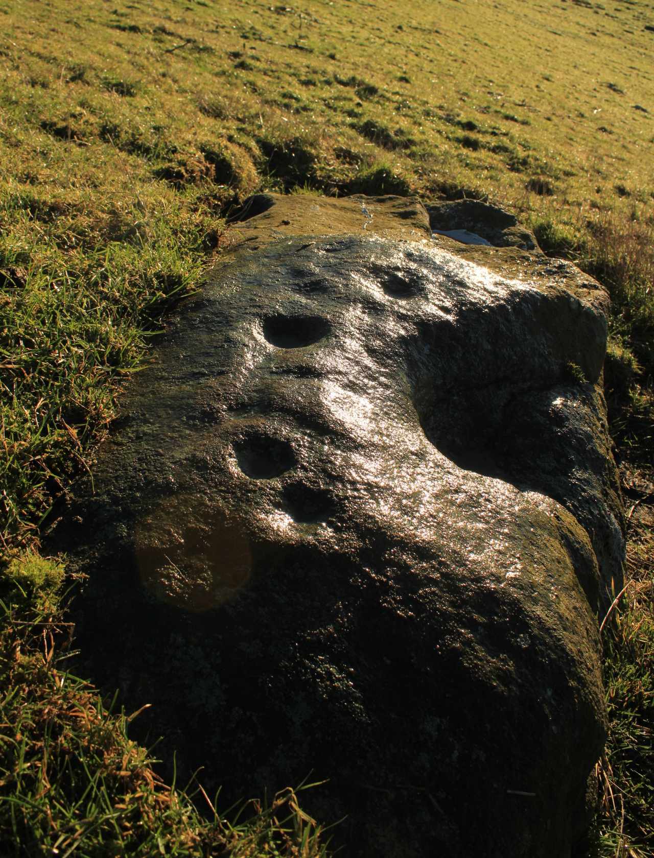
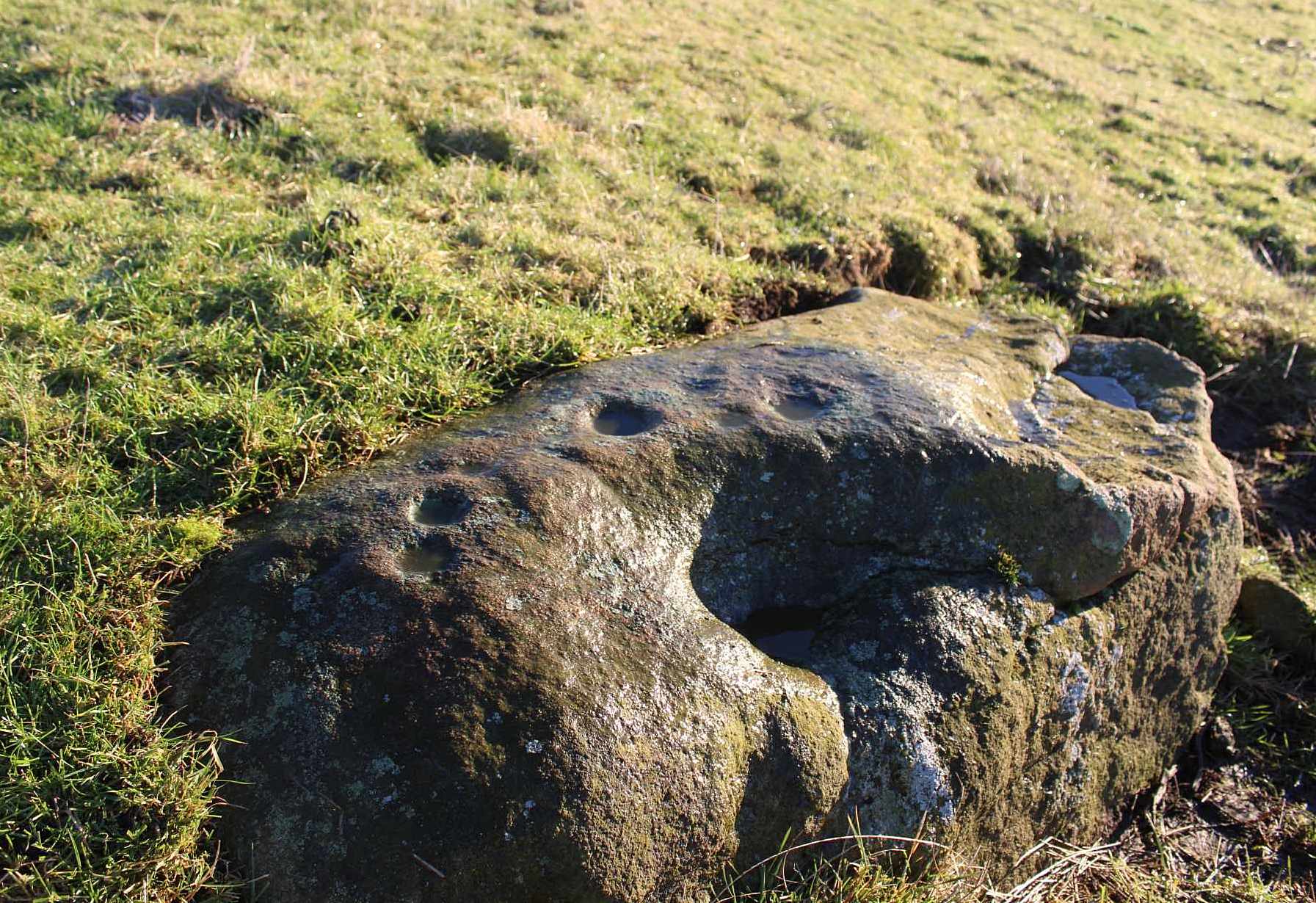
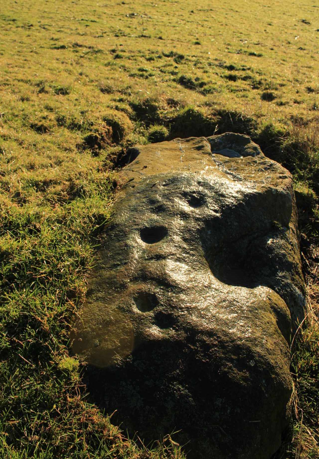
Cleland Stone, looking S
In an area that’s had some considerable quarrying done to it, we’re lucky to find that this carving still exists. It was rediscovered by Thomas Cleland (hence its name!) in the summer of 2024. It consists of four distinct cups, with a possible fifth (and maybe more?) on its smooth elongated surface. The cups, as we can see, are quite deep and unmistakable. An incomplete ring seems to be around at least one of the cups; and there seems to be a carved straight line running between another two of them. A simple but distinct design and in a lovely setting gazing cross the Airedale valley from here.
There are very few other carvings in this neck o’ the woods (the Great Laithe Wood carving aint too far away), but the fact that this has been found would suggest that others are probably hiding away in the undergrowth. Check out the Iron Age Horse Close Hill enclosure while you’re up here too.
Acknowledgements: A huge thanks to Thomas Cleland, not only for finding the carving, but also for allowing use of his photos in this site profile.
Cup-and-Ring Stone: OS Grid Reference – NT 200 522
Also Known as:
La Mancha
Archaeology & History
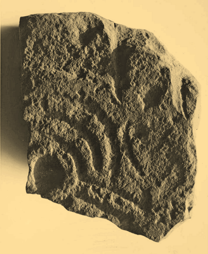
Simpson’s 1867 drawing
This is what I’ve come to term dyslexic cup-and-rings, due simply to the fact that it’s a cup-and-ring stone carving, but the cup in the centre hasn’t been carved out or pecked away. They’re rare – but for some odd reason, a small cluster of them occurs in this part of lowland Scotland. The Drumelzier carving 13 miles SSW is one; the Carnwath carving 14 miles west is another; 14 miles to the south, the multiple-ringed carving in the Woodend cairn had no defined pivotal cup; and in Childe & Taylor’s (1938) short piece on the Hawthornden petroglyphs near Roslyn (less than 10 miles northeast), they noted—like Simpson & Thawley (1972) years later—the peculiarity of “the complete absence of cups”, akin to Lamancha’s carved rings. (although we should be cautious about the archiac nature of the Hawthornden carvings)
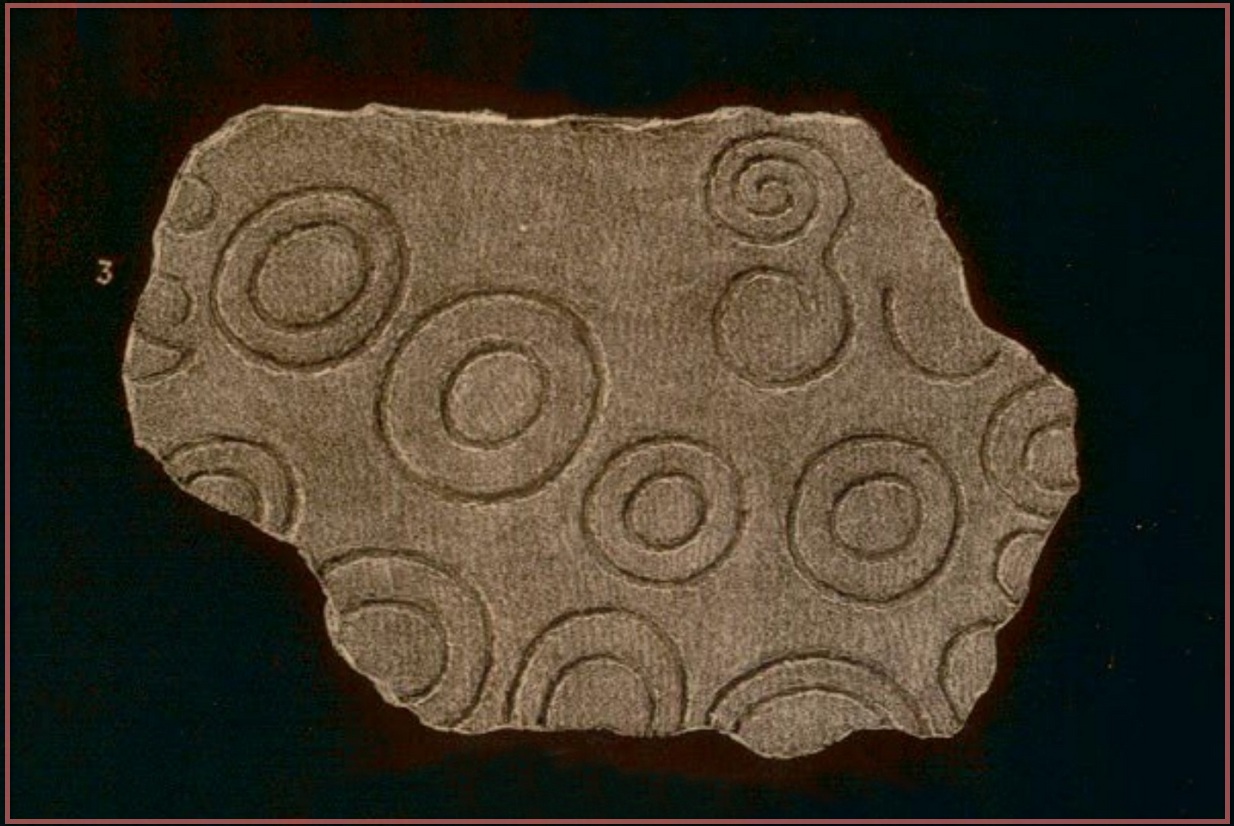
The carving here was first mentioned by one of the great petroglyphic pioneers James Simpson (1866; 1867):
“A broken slab, about two feet square, covered with very rude double rings and a spiral circle, was found by Mr Mackintosh, at La Mancha, in Peeblesshire, in digging in a bank of gravel. There were some other large stones near it; none of them marked. Possibly this stone, therefore, is sepulchral in its character.”
Lamancha carving (G. & A. Ritchie, 1972 )
Eoin MacWhite (1946) was somewhat sceptical of Simpson’s “sepulchral” association, simply due to there being no account of a burial here. But in Simpson & Thawley’s (1972) survey of passage grave art, they thought the Lamancha carving was from “a possible cist slab.” We might never know for sure one way or the other.
The carving ended up living in Edinburgh’s National Museum where it should, hopefully, still be on display. As a result of this, it received the attention of the Royal Commission doods who gave a good description of the design in their Peeblesshire Inventory (1967). They state that it
“is irregular in shape and has maximum dimensions of 2ft 6in by 1ft 10in; it averages 4in in thickness. The markings, which have all been formed by the pecking technique, occur mainly on one face, the most common symbol being single or double rings. There are four complete double-ring symbols, in which the outer rings measure from 5in to 7in in diameter, and the inner rings from 2in to 4in. Round the margin of the face there are the broken arcs of five more double-ring symbols and of five single rings and one small V -shaped figure. As well as the ring markings there is a double-spiral, each lobe of which measures about 4in in diameter. In one lobe the spiral has two and a half turns and in the other only one turn. In addition, in a space which is otherwise free of markings, there is an area, about 4in square, heavily pitted with punch-marks measuring one-eighth of an inch across and one-sixteenth of an inch in depth. A remarkable feature of the stone is that three incomplete single ring symbols have been made on one edge. They have been formed by the same technique and measure 3in across; as in all the other symbols, the grooves themselves measure about half an inch in width and about one-eighth of an inch in depth.”
McWhite, Eoin, 1946 “A New View on Irish Bronze Age Rock-Scriblings”, in Journal Royal Society Antiquaries, Ireland, vol. 76, 1946.
Morris, Ronald W.B., “The Cup-and-Ring Marks and Similar Sculptures of South-West Scotland,” in Transactions of the Ancient Monuments Society, volume 14, 1967.
Morris, Ronald W.B., “The Cup-and-Ring and Similar Early Sculptures of Scotland; Part 2 – The Rest of Scotland except Kintyre,” in Transactions of the Ancient Monuments Society, volume 16, 1969.
Morris, Ronald W.B., The Prehistoric Rock Art of Southern Scotland, BAR: Oxford 1981.
Ritchie, Graham & Anna, Edinburgh and South-East Scotland, Heinnemann: London 1972.
Royal Commission on the Ancient & Historical Monuments, Scotland, Peeblesshire – volume 1, Aberdeen University Press 1967.
Simpson, D.D.A. & Thawley, J.E., “Single Grave Art in Britain,” in Scottish Archaeological Forum, no.4, 1972.
Simpson, J.Y., “On Ancient Sculpturings of Cups and Concentric Rings,” in Proceedings of the Society of Antiquaries, Scotland, volume 6, 1866.
Simpson, James, Archaic Sculpturings of Cups, Circles, etc., Upon Stones and Rocks in Scotland, England and other Countries, Edmonston & Douglas: Edinburgh 1867.
Cup-and-Ring Stone (removed): OS Grid Reference – NT 1872 4072
Archaeology & History
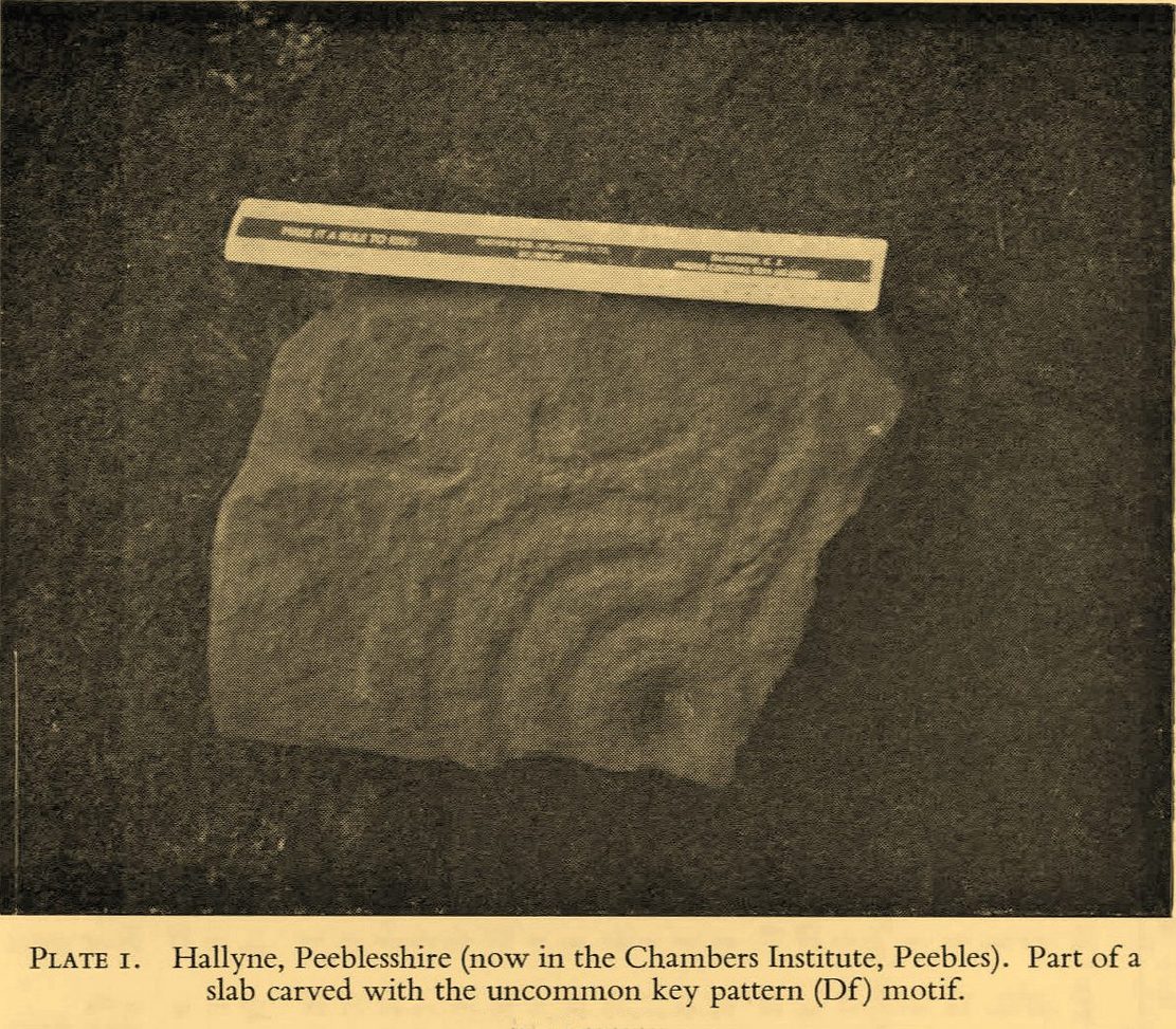
Included in the standard catalogues by Ronald Morris (1967; 1969), this carving was brought to light fortuitously by the local farmer who, thankfully, recognized its archaeological importance. Etched into a small flat broken block of stone, he noticed a cup-marking and the remains of a triple-ring around it, with grooves running out from the central cup. It was described in detail by the Royal Commission (1967) lads in their county survey where they told:
R.W.B. Morris’ 1967 photo
Hallyne carving in Peebles Museum
“During the excavations at the Roman fort at Lyne…in June 1959, a stone bearing cup-and-ring markings was found lying beside the fence that crosses the North Annexe. According to local information it was found while ploughing in the field on the NE side of the fence. It is a sandstone block, measuring 1ft 5in by one foot, and with an average thickness of 8in. It is clearly a mere fragment of what must have been a larger slab, but it is impossible to estimate its original dimensions. The markings consist of a single well-formed cup, 2in in diameter and three-quarters of an inch in depth, now partly surrounded by the broken arcs of three rings, which, if complete, would measures about 4in, 7in and 10in in diameter respectively. The rings are all half an inch in width and one eighth of an inch in depth. From the innermost ring two radial grooves, set one inch apart, extend outwards for a maximum distance of 4in. They interrupt the two outer rings, which stop short on either side of them, leaving a gap of about half an inch. The grooves are slightly narrower and shallower than the rings. The whole symbol has been formed by the pecking technique and punchmarks are still remarkably fresh. Outside the outermost ring there is a very shallow depression, one inch in diameter, which may be another cup-mark; in addition there are several recent scars caused by the plough.”
It was moved to the museum in Peebles shortly after being found and remains there to this day, apparently. I’ve not seen it.
References:
Morris, Ronald W.B., “The Cup-and-Ring Marks and Similar Sculptures of South-West Scotland,” in Transactions of the Ancient Monuments Society, volume 14, 1967.
Morris, Ronald W.B., “The Cup-and-Ring and Similar Early Sculptures of Scotland; Part 2 – The Rest of Scotland except Kintyre,” in Transactions of the Ancient Monuments Society, volume 16, 1969.
Morris, Ronald W.B., The Prehistoric Rock Art of Southern Scotland, BAR: Oxford 1981.
Royal Commission on the Ancient & Historical Monuments of Scotland, Peeblesshire – volume 1, HMSO: Edinburgh 1967.
Cup-Marked Stone (destroyed): OS Grid Reference – SE 152 393
Also Known as:
Carving no.195
Archaeology & History
A basic cup-marked stone could once be seen up near the top of the slope behind the Bay Horse pub as you’re heading up to Baildon village. The site would seem to have been destroyed following the demolition of buildings thereby. A photograph of the carving was taken and it was described, albeit briefly, by Sidney Jackson (1961), who told:
“A small boulder with two cups in it was found at the junction of a narrow bye road leading to 30 Lane Ends, Baildon, with the road which runs behind the Bay Horse Inn, on 12 April (1961), by Mr Alan E. Rowe, 10 Beaufort Grove, Bolton, Bradford and a photograph of it was taken for the Museum Reference Collection.”
Years back I contacted the Bradford Museum about this photo and they were about as helpful as a zionist in Palestine! – i.e., I never got to see it. It would be good if someone could locate the image.
References:
Boughey, Keith & Vickerman, E.A., Prehistoric Rock Art of the West Riding, WYAS: Wakefield 2003.
Jackson, Sidney, “Cup-marked Boulders, Baildon Finds,” in Cartwright Hall Archaeology Group Bulletin, volume 6, no. 6, 1961.
From the Askwith Moor car-park (SE 1757 5067), walk along the road north for a few hundred yards until you reach the gate on your right and head through the heather to the Death’s Head carving. From here walk in a northwesterly direction up the gentle slope for 50-60 yards and, before reaching its crown, keep your eyes peeled for a low flat stone with a curvaceous crack running roughly halfway across it. If the heather’s deep, you might not have a cat in hell’s chance of finding it!
Archaeology & History
This carving isn’t much to look at on two levels: i) it’s a pretty simplistic design with no rings, and (ii) it’s very faint and almost impossible to see until the light is just right—except for one of the cups, which itself might be natural (there are a few like that amidst the Askwith complex). It’s very much a carving for the purists among you, as I always say. Nonetheless, for the record:
Crap sketch of design
Faint cups visible
The most notable element is the single “cup mark” on the more easterly section of the stone, on one side of the natural crack. It catches your eye and is what makes you give the stone a little more attention, although I couldn’t make up my mind whether this was Nature’s handiwork or humans. It may be a bit of both. On the other side the crack we can see a small group of very faint eroded cup-marks — just! What seems to be three of them cluster in a small triangle formation, but one of these may be natural (tis hard to say for sure), with another isolated cup closer to the crack, and a final one further to the outer edge of the stone. All are very faint but stood out when the sun was low on our recent visit here. Give it your attention when you’re next having a look at the settlement and cairnfield close by.
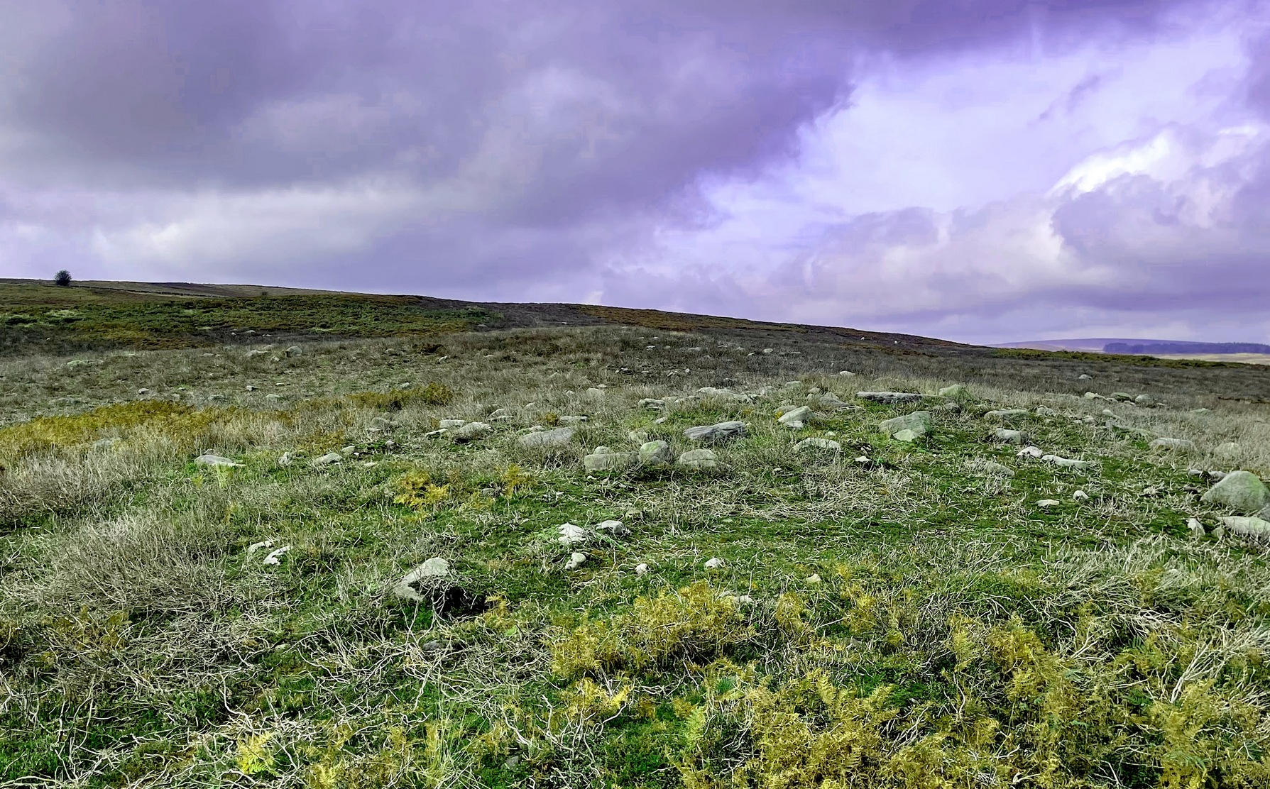
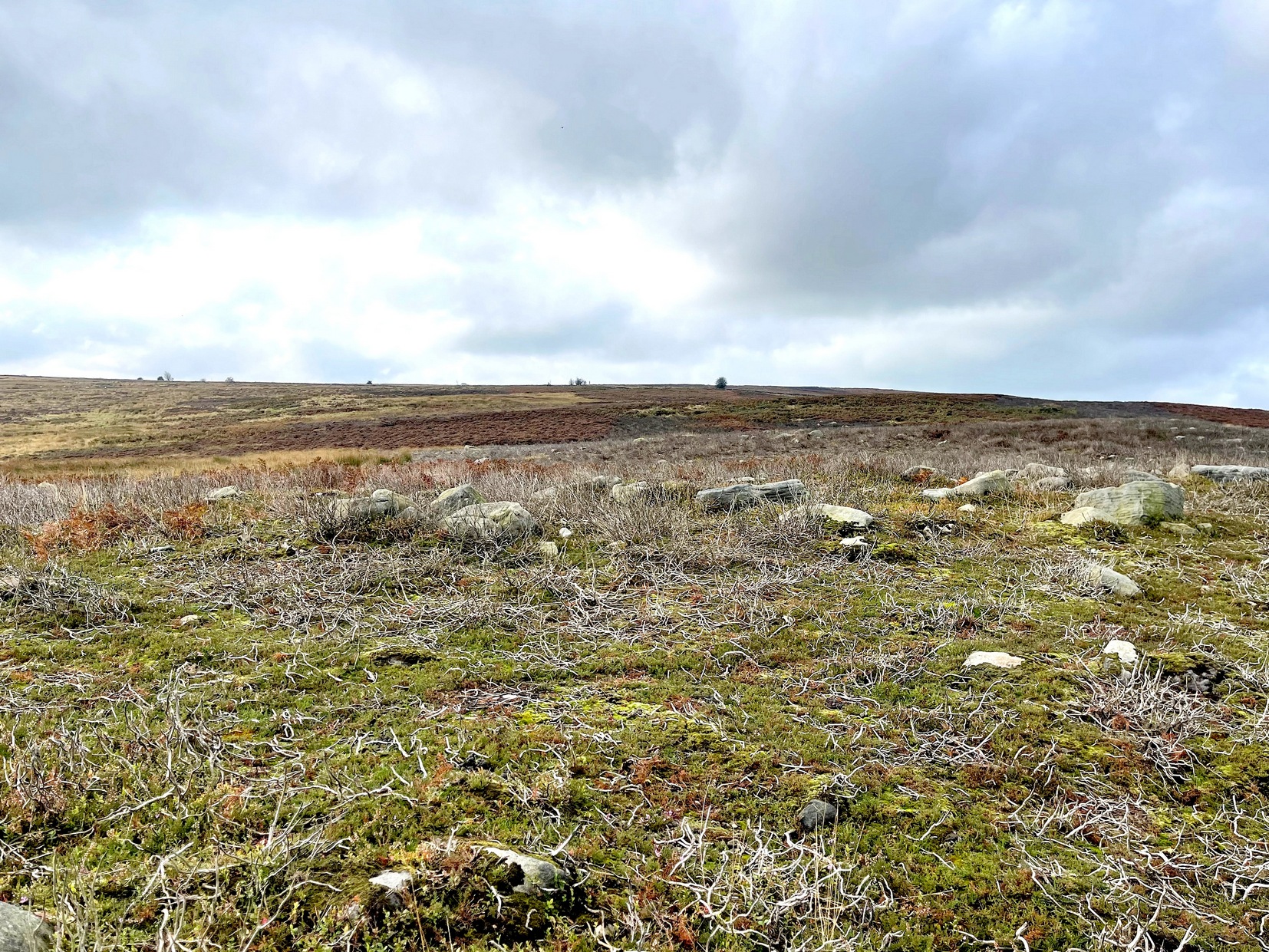
From the Askwith Moor car-park (SE 1757 5067), walk along the road north for several hundred yards and go through the gate on your right. Head northeast through the heather to the Death’s Head carving and keep along the same direction for barely another hundred yards onto the ever-so-slight crown of a small hillock. This is a hut circle you’re standing in/on. A few yards away just to the southeast of where you’re standing is the very denuded remains of this ring cairn.
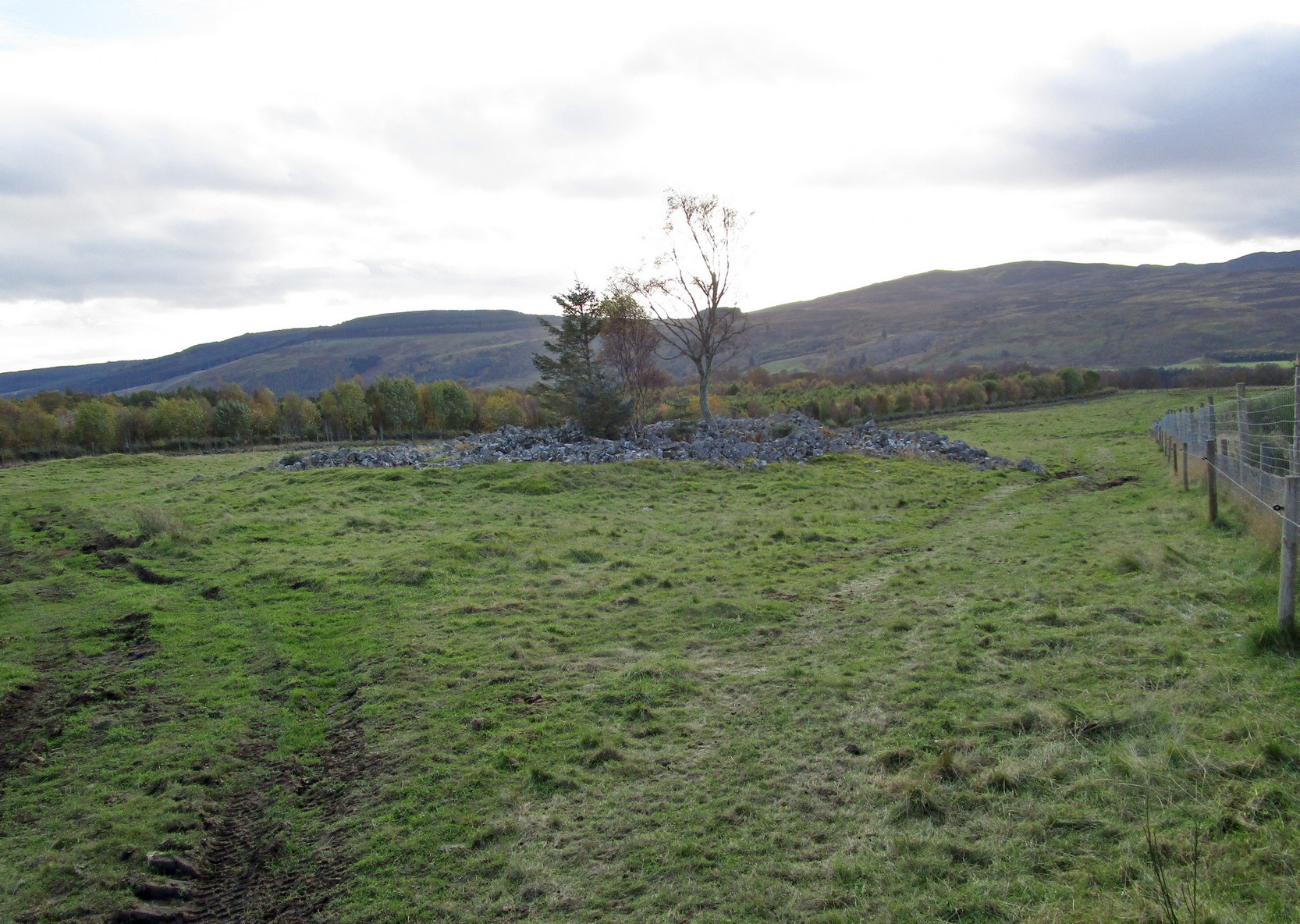
Archaeology & History
Low remains of rubble wall
Not visible when the heather’s in full growth, it’s nonetheless worth visiting if you’re trying to get a picture of the prehistoric landscape hereby. Less than 10 yards southeast of the notable hut circle on the small crown of a hill, it was first noticed by Sarah Walker on a group visit here recently. Roughly 12 yards across, the most notable section of the circle is the remains of the rubble bank on its east and southeastern sides, raised a few feet above ground level. The majority of the monument comprises of a scatter of various rocks and small stones within and round the edges of the circle. There’s a lot of scattering from other adjacent remains, such as the hut circle and nearby walling, that give the initial impression of it being little more than a spurious mess of stone; but the more you walk around and inside it, the more you come to recognize its structure.
It has that Bronze Age hallmark look about it, but without an excavation this is just educated guesswork. It might actually be older. The widespread mass of prehistoric remains all round here shows that it was once a mass of activity in prehistoric times. It’s a brilliant area, even if you can’t find this particular site!